
B TEAM WANTS TO SEND THE GRAND PARKWAY WHERE THEY WEREN’T ALLOWED TO GO 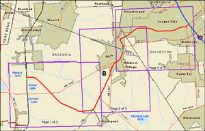 July 11th is the last day to make on-the-record comments about the route the Grand Parkway planners want to take from 288 to I-45 (known as Segment B of the 170-mile outer-outer loop). The finalized study documents published last week mention that proposed right-of-way runs across about 55 acres of wetlands — though that number isn’t precise: the document also mentions that the study authors couldn’t get permission to enter properties along 70 percent of the route, so the group had to use aerial photos to estimate. TxDOT’s desired route appears to hook in with SH288 at the intersection of CR 60 and follow the Brunner Ditch and South Texas Water Company canals southwest most of the way to SH35; from there it would swing back northeast just past Alvin, then eastward to hit I-45 where FM 646 does. [Previously on Swamplot]

Does anybody know why the segment between SH 288 & SH 35 takes such an indirect alignment out toward Liverpool?
.
Also, does anybody know whether the SH 35 project, the Alvin Freeway, is anybody’s priority? (It should be, even if it isn’t.)
Whoa. Why does this segment zig-zag so much? You’d think that BW8 planners could not see the beauty of Loop 610’s graceful circle from a map then copy it.
.
What’s the point of heading east or west but have to go north or south to do it? Do it right or don’t do it at all.
Regarding GP in Brazoria County, I’ve been told the unusual route is due to land and home owner opposition. Ultimately highway projects tend to follow the past of least resistance.
RE: Niche and Planner
.
This alignment used to really bother me until I realized they were basically using Segment B as an excuse to construct a whole chunk of the SH 35 freeway. Your first thought is probably “this is useless for people trying to move between Galveston County and Fort Bend County.” Except the alignment south of Sugar Land is already so circuitous you’re better off sticking to Highway 6, which keeps getting upgraded with new overpasses.
.
Segments A, B, and C make more sense if you think of them as a bunch of different spurs that have been linked together for marketing purposes. There’s a spur onto 59 for Fort Bend traffic, two spurs onto 288 for Brazoria traffic, and a crosstown connector between 35 and 45 that’s just there to knit the network together.
I don’t understand why the GP has to exist in the first place, but if they have to build it in Brazoria County, then why not just plop it on top of FM 1462, the east-west route that is the most direct? There’s already a road there.
Makes perfect sense to me considering I don’t even know why they plan on building that portion of the GP at this time.
.
Brazoria doesn’t need a grand parkway and obviously many don’t want it. It should just end at 69 until further development in that region.
There seems to be a lot of zig-zagging around private property, but when it comes to Brazos Bend State Park on the other segment (west of 288), they come waaaayyyy too close IMHO. I’d rather they keep the nature preserve intact and remote. It is increasingly precious as we lose open spaces in the metro area.
To Googlemaster and the others: The purpose of this roadway is to encourage development in these areas. More strip malls, gas stations and “convenience stores” to support all the folks that will be buying new homes even farther away from Houston. No transit infrastructure – just taxes subsidizing far out housing for developers. No one asked for this road except those who would profit by it.
@ Purple City: Yeah, I was trying to look at it from that vantage point, that it gets a lot of SH 35 work done faster, but I just can’t bring myself to rationalize it — unless there’s some sort of plan to tie it into a second Galveston causeway. If that’s the case then at least it would be efficient for evacuation purposes. Otherwise, the amount of land area within Brazoria County that would have to be developed to have a spur to Liverpool make the slightest bit of sense is totally unreasonable.
.
Once upon a time I was a kid that would make a drive to Galveston County from south Texas, up US 59. One could take SH 35, SH 6, or Beltway 8, and in each case, regardless of whether it was a direct or meandering route, it’d take about the same amount of time. It wasn’t fast by any means. There’s still a need IMO for more direct connections between suburbs of Houston, both for intraregional commuters and for extraregional trips. Neither Segment C or B seem to be designed with this in mind. I don’t get it.
.
Now maybe that’s all that was left over after better options had been eliminated from public input. Maybe. All the same, from a policy perspective, if that’s the case, then I have a very difficult time justifying the sections of Grand Parkway between Rosenberg and Alvin as they’re laid out. Very difficult. The money would be better spent on SH 6 & SH 35.
One other thing I’ve heard recently (from reasonably well-connected sources in Brazoria County) is that the 288-Alvin segment of the GP is a much lower priority than the Alvin – Gulf Freeway segment, which should happen in the next 5-7 years.
Wetlands and pastureland that absorb river floods and hurricanes, be damned…as will anyone who buys into GP-induced suburban development in Brazoria County.
RE: RE: Niche
.
In truth, Segment C is messy because Segment D was. Jogging east of Pecan Grove, as opposed to straight down to Richmond, made it much less useful as a bypass for Victoria/Corpus long distance traffic. And the decision to hook the southern end into Crabb River Road pretty much guaranteed that Segment C would start out headed the wrong direction.
.
One wonders if the Liverpool segment will get built as a two-lane with an oversize ROW and then just never advance beyond that point. Red Bluff was a dotted line on a map for so long that they ended up selling off the right-of-way where the high-speed turns would have been at Fairmont (now FBC of Pasadena) and BW8 (now a Target-anchored power center).
@ Planner: That’s wonderful news. The Alvin Freeway (tollway?) should have been prioritized a long long time ago, in anticipation of the Gulf Freeway being under construction — forever.
@ Miz Brooke Smith: Brazoria has heavy clay soils, which aren’t very pervious to intense rainfall anyway; modern development standards (which apply both to new greenfield projects as well as to highways) feature plenty of stormwater detention. I wouldn’t even be surprised if new development on former pasture were to result in a net benefit for existing communities that are located downstream.
Why even connect to 35? I say with that swing down south, just keep going to Galveston as a hw6 alternate. Connecting the west side of town to the island could help boost the island tourism and region economy. It can also provide a good evacuation route for hurricanes.
@TheNiche are there any plans for a west Galveston Island causeway? A bridge from the Jamaica Beach area could be huge for hurricane evacuation efforts, and serve as an effective relief route for island-bound Gulf Freeway traffic.
@ Niche: Just to make sure you’re not misunderstanding me, I was talking about the Alvin-45 segment of the Grand Parkway, not the Spur 5 – Alvin highway.
@ Zach: I had a similar thought, that Liverpool would be a great spot for a connection to a second causeway if there ever were one. Its not impossible, although it does seem very unlikely.
I have no response from previous suggestions and wonder if this will generate any reply? I can’t understand why TXDoT and the Grand Parkway venture isn’t taking advantage of existing ROW and construction in place from the Alvin portion (35 south) of Segment B to I-45 and travel along the FM1764 corridor that would then connect with the Emmett Lowry expressway that already connects east of I-45 to 146. The environmental impact from Hwy 6 (north of FM517 to I-45) is eliminated, much of the roadway is in place and new construction from 35 to 6 across vacant/less developed land would be minimal and promote economic expansion as well as core evacuation routing.