
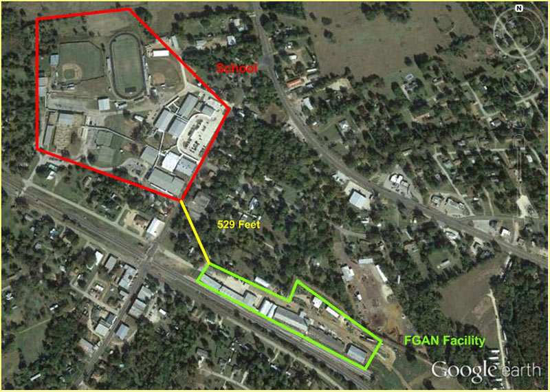
The image above, showing a fertilizer-grade ammonium nitrate (FGAN) facility loitering as close as 529 ft. from the edge of an unidentified school campus, appeared on slide 13 of a US Chemical Safety Board presentation in Waco last week. But where is this place? And where are the other Texas locations where similar facilities storing large quantities of ammonium nitrate are sited within half a mile of a school? The Board warns that there are 18 such cozy-ups in Texas, but doesn’t identify their locations — even the image shown above, grabbed from Google Earth and outlined, omits any street labels.
The Waco presentation talked through the safety agency’s recently released findings on the 2013 explosion in West, Texas (located in Central Texas). A school and a nursing home were among the nearby buildings that received serious damage from the fertilizer blast, which killed 15 people and injured hundreds; the safety board report indicates that holes in that city’s zoning laws allowed the storage facility to be slowly grandfathered into a residential area.
Finding out where chemical storage facilities are located, and what they store, is now more of a fun guessing game than it was before the West explosion: In 2014, then-attorney-general-now-governor Greg Abbott’s office ruled that state Tier II data, which documents hazardous chemical storage at private facilities, would no longer be accessible to the public. But those open records weren’t really necessary, not if you’re really trying to find the facilities: “You know where they are, if you drive around,” Abbott told reporters.
***
Abbott tried to clarify the ruling in the wake of a backlash over the perceived breach of community right-to-know laws, saying that not releasing the data was a matter of Homeland Protection. But citizens can still personally “go to any chemical facility in the entire state of Texas and say, ‘Identify for me all chemicals you have on your facility,’ and [they] are entitled to get that information within 10 days,” he said.
The Houston Chronicle, along with a number of other media outlets, decided to give that a go: the Chronicle contacted 20 companies in June of 2014, requesting their chemical storage data. Most of the companies sent their Tier II reports, while 5 sent a simpler chemical inventory list; 2 (including the ChemQuest facility in Pasadena) did not respond, and 1 waited 11 days to ask for the inquiry to be resubmitted.
Here’s a dramatically-soundtracked video summary of the safety board’s report:
- Public Meeting Presentation (January 28, 2016) [USCSB]
- West Fertilizer Explosion and Fire [USCSB]
- Abbott says companies must release chemical info but state does not [Houston Chronicle]
- Abbott: Ask Chemical Plants What’s Inside [Texas Tribune]
Photo of unidentified Texas school near an FGAN storage facility: USCSB
I toured the West, TX site few months after the explosion (was there for unrelated business reasons) and it was one helluva explosion, but it was very localized, the railroad track birm redirected a lot of the blast. As far as the cause, all the locals will tell you it was an intentional fire set by a local well known nutjob who has a history of seeking attention and wanted to be an honorary fireman. He set the fire to call it in and “save the town”. Luckily he died in the blast as well.
Why the focus on schools and nursing homes only? Any development inside a blast radius will be leveled and the people there harmed or killed. This includes homes, businesses, busy intersections, etc. Towns grew up around these ag facilities long before the West explosion. Now that we know it can happen, we should seriously consider moving them out to the middle of nowhere. That’s where most of the farms they service are located anyway. The Texas City explosion that happened in the 1940’s was similarly huge and lethal, and was caused by the same chemicals. The real tragedy is when we don’t learn from past mistakes, and then make them again.
As with most government efforts, Tier II reporting is kind of a joke. I file the reports for my company, and a lot of chemicals are exempted, and there is virtually no oversight of the reports nor enforcement for anything other than failure to file. The reports themselves do not show the exact location of chemicals, nor does it give much info on how they are stored or used. However, I would guess that Abbot’s closure of the data could be struck down by the Supreme Court since the whole point of Congress’s right-to-know legislation that triggered this law was to make the info available to the public.
The town on page 11 of the report is Fairfield, Texas. Capps True Value Hardware and Ag Center.
Slide 13 is Elkhart, TX in Anderson County. Don’t ask me how I was able to find that out (hint: Google Earth Pro ROCKS!).
Most of these facilities are probably Feed Stores with fertilizer and seed trucks that go out to the neighboring farms/ranches. They were built along the RR tracks to get their deliveries by rail. And the town also grew up around the RR tracks. Other towns that might be on that slide deck – Buffalo, Jewett, Normangee.