
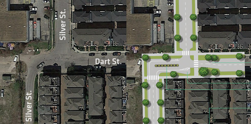
In the small but growing city tradition of redoing street plans in your spare time, urban planner and general Houston improvement brainstormer Jesse Thornsen has recently launched a website to showcase weekly ideas for making bits the local streetscape easier to navigate (by bike, foot, car, or other means). This morning’s addition: how to smooth out the westward jog in Silver St. as it crosses Dart St. The spot (shown in the above left-to-right conceptual before and after) is southeast of Annex Houston automobile storage and the Silver Street Studios complex; not quite due west lies the Shops at Sawyer Yards warehouse retail redevelopment.
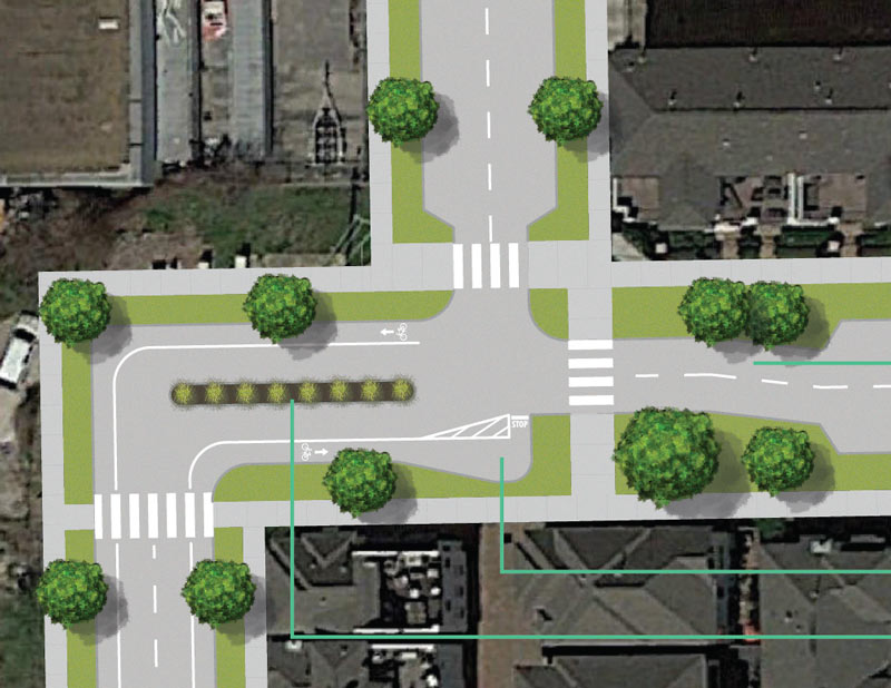
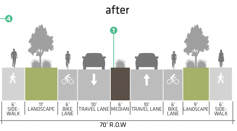
Thornsen’s plan adds sidewalks and a landscaped median (to discourage vehicles from taking the most direct route straight through the jagged intersection). Thornsen points out that the section is designated for both bikes and cars by the Houston Bike Plan; his redo includes bike lanes, including a queuing spot big enough for multiple cyclists to cozy up together as they wait to turn north. Here’s a close up and a cross section:
***
- Silver Street Offset [Thornsen StreetLab]
- Previously on Swamplot: What Happens When You Decide To Redo That Downtown Freeway Plan in Your Spare Time
Images: Thornsen StreetLab
Curious choice of a spot to focus attention on. Not exactly a heavily trafficked intersection and the jog currently acts as a means to calm traffic.
Is that to scale? A 70-ft right of way is YOOOGE for a low-traffic 2-way street. If you want a 6-ft bike lane why not just put a small median between the car lane and have it handle both North/South traffic.
.
Over 20-ft of landscaping? Plus a median? I suppose his intent is to provide the most ideal solution, but this sounds incredibly expensive with a very low return on value.
.
Just throw up a bunch of stop signs to discourage automobile use through the corner and spend the money on a major thoroughfare nearby like Houston Ave. for handling traffic from the studios.
So stopped being lazy and looked at the street on google maps. Those are indeed some massive streets they have over there. Kramer would be jealous.
.
Was all that originally spec’d out for lots of commercial trucks & traffics for the warehouses?
Silver St would be a great corridor to connect the Buffalo Bayou Park to the Heights Bike Trail
First Ward is number 1!
This is on my bike commute between the Heights and downtown. Please leave it alone, it’s a good route because there is not much traffic and it connects to the pedestrian bridge across Memorial.
Bicyclists don’t need fancy lanes to pin us into complicated intersections, we need routes with less cars or cars doing predictable things. Silver Street works well.
If you want to see how adding a dedicated bike trail can make things more dangerous for cyclists, try riding across the part of the trail that crosses the Sawyer Target parking lot during daylight hours.
I’d hate to see what that median would look like after a semi comes through. Ouch.
@Frank the MKT trail by Target is nothing like this, not sure what kind of comparison you are trying to draw? Also, not sure what is so predictable about the traffic at this intersection as it currently is? Cars are always cutting through opposing lanes here. It sounds like you believe this route is your hidden gem that you want to squander to yourself.
.
@Freddy your right, the offset does currently calm traffic, which is nice. It seems like this design would calm it further. At least it wasn’t the typical “lets throw an S-curve to make traffic flow smoother” solution because that would enable cars to speed up.
Silver Street is one of only three places you can cross both railroads in the First Ward (the others at Sawyer and Houston Ave) so this intersection sees a decent amount of car traffic. But the big need is for some type of sidewalk that runs along Silver from Dart to Washington and some improvements to Silver Street that would make it easier to bike on. Right now you have to wander through some dirt parking areas that are usually strewn with broken glass or become swamp land after the rain. I agree that Houston Avenue would be the more logical place to upgrade the street to handle car traffic but Houston Ave is a nightmare to bike and walk on (unless you enjoy going through the hobo bathroom that the pedestrian tunnel has become) so Silver could be a great place to put in bike/walking amenities and Houston Ave could remain the primary car route.
If these are neighborhood streets, I’m ok with it. If not then you need to make a left turn lane.
@Frank
Yes, that Target parking lot/bike crossing is a mess. The property mgmt company needs to make the intersection near the AT&T store a four way stop plus add stop signs for the trail riders (if there already aren’t any).
@Limestone: stop signs on the bike trail will just move bike traffic into the street. I already bike in the street there because cars don’t stop at the stop signs, but instead stop blocking the trail.