
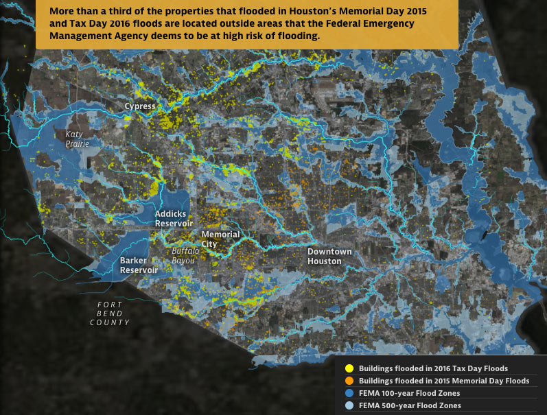
From some of the same folks who brought you those fun-with-worst-case-scenarios hurricane flood maps earlier this year —  Neena Satija and Kiah Collier of the Texas Tribune, and Al Shaw of ProPublica — comes a fresh set of animated maps of a few of Harris County’s most flooded and floodable places, along with a bit of investigation into how they got that way (and whether that might change any time soon). The new illustrated presentation shows off the spread of properties that took a dip during some of Harris County’s last few citywide submersion events (flooded properties from Tax Day 2016 are shown in yellow above, along with the Memorial Day 2015 flooded properties in orange).
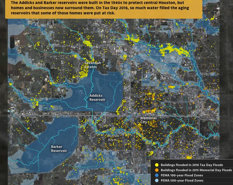
Texas A&M Galveston researcher Sam Brody tells the authors that “more people die here than anywhere else from floods. More property per capita is lost here. And the problem’s getting worse.â€Â In sorting through some of the whos, whats, and hows of Harris County’s flood infrastructure and chronically soggy residents, the article juxtaposes the recent flood damage data with the likes of FEMA-mapped 100- and 500-year flood zones (shown above), a visual tally of the land area developed last decade, and a view of what’s left of Houston’s coastal prairie (as of 2010):
***
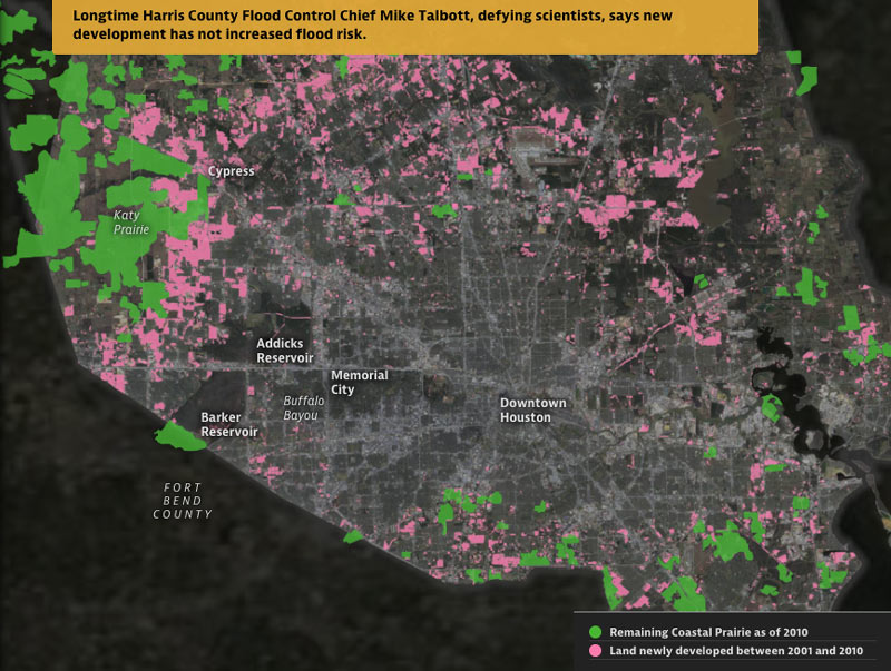
Satija and Collier write that “scientists, other experts and federal officials say Houston’s explosive growth is largely to blame: As millions have flocked to the metropolitan area in recent decades, local officials have largely snubbed stricter building regulations, allowing developers to pave over crucial acres of prairie land that once absorbed huge amounts of rainwater.”
The authors also catalogue some of the more night-and-day disagreements between some of Harris County’s flood-minded officials, the area’s natural hazard scientists, and the county’s dampest residents, on topics such as: whether or not there’s any connection between steadily expanding suburban fringe and the recent flooding increases; whether or not the region’s decades-old rules on drainage and development work or are meaningfully enforced; whether or not the recent major storms are potentially climate-change-related or just flukes; and what kinds of solutions (if any) are possible to some of the county’s flooding problem —engineering-wise, or politically.
- Boomtown, Flood Town [ProPublica and the Texas Tribune; text-only version here]
- Previously on Swamplot: Â A Quick Tour of Spots Where FEMA Will Expand Its Flood Hazard Zone In January;Â Cross-County Accounting for the Houston Flooding Puzzle;Â Repeated 100-Year Flooding Adds Up to Houston’s Wettest Year and a Half on Record;Â Finally, the Interactive Houston Hurricane Freakout Maps You’ve Been Waiting For
- Flooding coverage [Swamplot]
Maps: ProPublica/Texas Tribune


Considering the storms that hit Houston were in excess of the 500 year in the areas where flooding exceeding mapped floodplains, we did very well.
Many of the watersheds flooded as predicted such as Cypress, Addicks, Greens, Brays, Spring, and Willow. The live monitoring mirrored very closely the models used to map the floodplains.
Talbot has standing to make his statement that new development didn’t cause the flooding. It was the extreme rainfall amounts in a short period of time. As I watched the gauges on Harris County’s emergency management site, I knew the areas that were going to get hit with bad flooding. Green, Cypress, and Willow were a no brainer for the heavy flooding.
I guess I could have ginned up a report, got paid, and made some press rounds too without providing context and know the media wouldn’t know any better.
Sounds like our elected officials have no clue. That they are causing the “urban flooding” was a big point of the article. Our do nothing mayor will refer you to speak to that clown Costello if you contact him about flooding. But the article clearly indicated that Costello is not in any way up to the task and doesn’t even have a staff. These guys are losers without a plan. Listen to the experts!
Flooding? What flooding? The sheeple of Houston approved a tax increase several years ago via a “drainage fee” to eradicate the issue forever. We were saved!
I like how they still pedal the WRONG premise that the prairie absorbs “huge amounts of rainwater”.
‘Satija and C0lliers write that “scientists, other experts and federal officials say Houston’s explosive growth is largely to blame: As millions have flocked to the metropolitan area in recent decades, local officials have largely snubbed stricter building regulations, allowing developers to pave over crucial acres of prairie land that once absorbed huge amounts of rainwater.‒
The developing prairie in west Harris and north Fort Bend Counties have a relatively thin layer of top soil and really thick layer of clay. The only region in the metro that can truly absorb water is the piney woods in north Harris and Montgomery Counties. Design criteria for development across the region take this into account.
I guess when you say “scientists, and other experts” the media and public just agree with the statement.
Whatever, Maybe I will be happy once the coastal prairie is gone. Houston doesn’t really value its unique ecosystem anyway. We can then just be nostalgic about a time when there was a chance to save it. Now we just live in a state of anxiety about its future destruction.
Every home is susceptible to flooding. There are NOT ANY NON-FLOOD AREAS. There are only homes that are more likely to flood and homes that are less likely to flood.
The likelihood is expressed, on flood maps, by the single year probability of being flooded(with some other factors). This does not properly describe the likelihood of being flooded during the course of a longer time period, of say a thirty year mortgage.
Homes eligible for NFIP preferred flood rates can have up to just less than a one percent chance of flooding annually. These preferred areas are what the public thinks of, euphemistically, as non-flood areas. Assuming a point 009 probability(just less than one percent) a home has a twenty percent chance of flooding, at least once, over the course of a thirty year mortgage(look up binomial probability). An alternative way to think about it is that one in five homes, in preferred flood zones, will flood over the course of a thirty year mortgage.
You are actually more likely to experience a flood than a house fire in a preferred flood area.
https://pdfs.semanticscholar.org/481f/a6d721130ae7dbed72a2a278e7868128b0d2.pdf
https://journals.uair.arizona.edu/index.php/jrm/article/viewFile/8549/8161
The science on the water storage capacity of prairies is well established and frankly very old. Prairie grasses have root systems that are 10-14 feet deep. They break up the surrounding clay soil with biological material. That makes the prairies a giant sponge. This is well documented and not up for debate. Also, prairies are home to wetlands and prairie pothole topography that also aids in stormwater detention and storage.
The problem in Harris County is very clear. The County has given developers a free pass to develop as much as they want and wherever they want in order to try to compete with Fort Bend and Montgomery County for growth. Saying that the flooding was “expected” in certain neighborhoods is like saying that learning disabilities are expected when using lead paint in schools. What government would permit development in an area when flooding is basically inevitable? It is basically like permitting a new subdivision next to a military target range and then saying “so what?” when an errant mortar round kills a family sitting at the dinner table.
One billion in damage and sixteen deaths is a huge price to pay for never saying “no” to developers. If these rain events are the new normal and Harris County and the City do nothing more than build a few detention basins and widen a few storm sewers, we are going to see a big problem as growth will only compound existing problems.
I had a lot that I wanted to build a small resturant / coffee bar for people that lived near by. Rather than parking out front, I was going to have green space (think ‘park’ like slides vs. ‘park’ like cars). Water collection (+ gray water) would have kept everything green and growning.
.
City wouldn’t let me. “Sorry, gotta have 10000 spots”
.
So I gave up the idea.
.
Guess what’s there now? A shop with a giant asphalt parking lot. Yeah, I have no idea why we have so much flooding.
Well put, Old School!
The elected officials are idiotic special interest tools. Talbott of HCFCD is one too. I wonder if his house flooded.
Remember, almost all of the FEMA flood zones are riverine or coastal models. Localized flooding and ‘ponding’ is not mapped in many cases. With Houston’s areas of massive impervious surfaces mixed with record rainfalls, you will get lots of this type flooding. On the other note, you cannot completely discount the loss of pervious surfaces upstream.