
WOODLAND HEIGHTS BUS MAPPERS TO METRO: YOUR NEW ROUTE PLAN MISSES THE TARGET 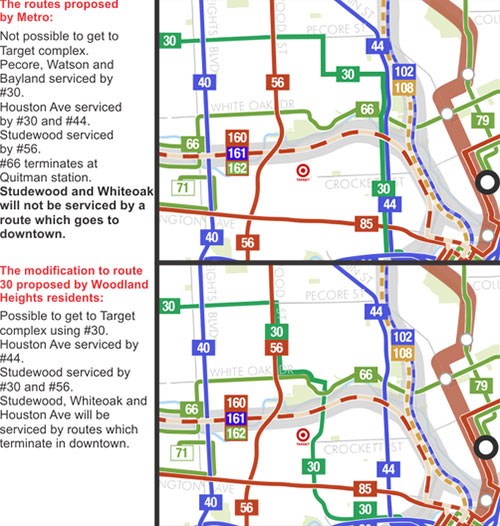 Metro says it’ll be ready to go with its new bus network on August 16, but that hasn’t prevented various groups from petitioning the transit agency to make late adjustments to its route map. One group of Woodland Heights residents is trying to get the new 30 route, which late in the process was shifted east to parallel the new 44 route down Houston Ave into Downtown, shifted west to Watson, Taylor, and Sawyer streets between Pecore and Memorial Dr. before entering Downtown from the west. The current proposed alignment leaves the Sawyer Heights shopping center and its Target without a bus stop. [Not of It] Diagram: Philip Teague

Just as a note, I did not create that diagram. I found it online. I have credited it to Philip Teague of Woodland Heights.
The “no bus goes downtown” argument is a non-starter. The #66 has a stop at the Red Line, so people can ride the #66 and transfer to the rail to go downtown.
.
I can kinda see their point about the Target though, and it’s difficult to see why Metro has the #30 overlapping the #44, unless there’s a problem with the existing bridge over I-10.
Have to agree about target, there is no way to walk to it besides the heights bike path, every other route is not really made for walking, how would you even get to/from the bus routes there.
This is actually an anti-transit petition masquerading as a pro-transit petition. The February “approved” plan had the #30 running east on 11th to Watson, then south on Watson and Sawyer. That got shifted east because certain interests didn’t want the bus on Sawyer. Now certain Woodland Heights residents want METRO to “abandon any route which utilizes Watson or Bayland”, despite the fact that Watson has hosted transit since the streetcar era. They’re calling attention to the need to service “commercial areas” as a gloss on their real goal of declaring certain streets verboten to buses.
.
And why don’t the good folk of Woodland Heights want the #30 on their streets? Follow that line to its northern terminus. Acres Homes Transit Center. Hell, it’s right there in the petition: “reclaim our neighborhood and our streets.” Reclaim from whom? Y’all know who.
It looks like METRO is actually soliciting “late adjustments” to the new route map. I was surprised to get an email last week (5/27) from METRO announcing “public hearings to receive comment regarding plans to adjust METRO’s New Bus Network service.”
I got another email today with links to several DRAFT maps:
METRO Public Hearing on METRO’s New Bus Network Wednesday, June 3, 6 – 7 p.m. & Friday, June 5, 12 – 1 p.m. 2nd Floor, METRO Board Room 1900 Main Street Houston, TX 77002
METRO will be soliciting comments regarding these proposed service changes.
METRO New Bus Network Bus Operator Maps – 051515 (http://goo.gl/6VSrF4)
Proposed August 2015 – Draft Saturday Schedules – 051515 (http://goo.gl/D79HA5)
Proposed August 2015 – Draft Sunday Schedules – 051515 (http://goo.gl/mS0IJr)
Proposed August 2015 – Draft Weekday Schedules – 051515 (http://goo.gl/v5mWvl)
If you wish to provide a comment, call 713-658-0180 or click Comments and select “Upcoming Service Change” for your comment category to submit a comment online.
I agree with Purple Cuty 100%. I do however also agree with the woodland heights idea. Only because it does makevthe most sense. I just disagree with their reasoning. You can no longer say noisy buses lower property values cause they do not. Buses are quieter than cars now andvthe frequency of the new 30 (30 min peak, 1 hour off peak) is much less than the current 40 (15 min peak, 30 min off Peak). Plus the span is shorter so they don’t need to worry about buses running all night like the 40 does. And both maps are wrong the 56 will terminate at Northline TC and the 34 will be extended to northline and have increased frequency and the 44 will be similar so the area will bevwell served even with the 30s reduced service.
The diagrams simply show how the Woodland’s Heights residents are trying to navigate routes outside of the Woodland Heights. Their argument is they want to provide access to the Target and downtown, but what’s the point? Clearly they don’t want to use the buses – if they wanted to use the buses, they would have routed them through the Woodland Heights. A good proposal would have 30 run along Pecore into Watson/Taylor and then into Target. The proposed 30 has a lot of redundancy with 56 and 66 and essentially steers clear of the bulk of Woodland Heights residents.
Some /quite a lot of the residents along Woodland Heights are mighty uppity /bigoted/prejudiced/racist down right plain a-hole s for trying to veto ANY buses transiting their hood. You’d think they’re in River Oaks /Memorial. I think they’re snooty,uptight,mostly white supposedly “educated” white property owners. What a load of BS. Maybe METRO will run buses ALL through the Heights and really make these up tight people REALLY get tense.
Purple City is fundamentally incorrect. The main reasons why Woodland Heights residents don’t want the bus running on Bayland (and to a lesser extent Watson) is one of neighborhood traffic safety. The entire neighborhood has undergone a traffic calming study over the last 6 years, hoping to install speed bumps, stop signs, and other calming devices. Where a Metro bus runs, they won’t allow speed bumps, stop signs, or new traffic lights. And these bus routes bring with them other speeding cars, etc.
This is an increasingly family-centered neighborhood. Our kids play in the streets, and many of them attend Travis Elementary. But the Bayland bus route bisects the neighborhood, creating a situation in which many kids have to cross Bayland (with few stop signs and no speed bumps) on their way to school. Bayland is a residential street, not a commercial street. Yet cars treat it like a major thoroughfare and speedway.
What the petitioners are asking for is that the bus routes be moved to commercial streets at the edges of the residential neighborhood. This would increase a person’s walk to the bus by at most a few blocks.
This has nothing to do with where the bus lines end or begin, nor with the ridership on the buses. Most of the petitioners are strong supporters of public transit.
If this is as stated above, it is a bit shady to go about it in this manner; however, to say someone who doesn’t want it in their hood is “bigoted/prejudiced/racist” is a bit much. I once lived close to a major bus stop in Houston and the trash/vandalism/crime was worse than any other place I have lived. I wouldnt want it because I am anti-crime, anti-littering, and anti-vandalism. Nor would I want a trendy Washington Bar… Does that somehow make me anti-bro?
It’s always traffic, isn’t it?
.
MW, that Woodland Heights traffic study is public. Measured 85th percentile speeds on Bayland were 29.1, 29.7, 30.2, and 26.6mph. 85ths on Watson were 29.7, 29.8, and 32.0. The posted speed is 30. NO portion of Bayland or Watson meets COH warrants for speed humps, regardless of the bus situation. Travis posts crossing guards on Bayland @ Beauchamp & Florence. You are hand-waving.
^^[incoming neighborhood propaganda]
As more new residents by homes in all of the heights neighborhoods including independence heights,garden oaks and other hoods nearby,many will try to get rid of the metro bus lanes since these hoods are going through gentrification.acres homes will also have no more metro bus lanes,northside village too.all these hoods that i mentioned are going through gentrification so people buying these homes will not want these bus lanes around so they can decrease the chances of poor people coming in theses hoods.many people from the suburbs are tired of the long commutes since houston is growing and traffic will get even worse in the suburbs as houston continues to grow.so people from the burbs are moving to these hoods in droves,but dont want the bus lanes because they dont feel comfortable being around people that they consider lower status in American society,even though you will see hipsters and some yuppies ride metro.why do you think they moved to the burbs in the first place to get away from those spooky lower status people in American society.but since these hoods are being gentrified they feel comfortable moving in.because they know those people will soon be gone.
I thought heights residents hated big box stores. So, they are arguing that they want publicly subsidized transport to a big box?
How many bus riders are there at peak hours on these bus line ? Not against bus service, would like to give it another try. Which route would get the most riders and get them to their destination or transfer centers efficiently. Reading some of the comments it’s amazing that some Heights residents decided its a gated community, or that the streets are private for their use.
The Traffic study data Putple City is referencing is from 8 years ago. A lot has changed in the area since then. The current Woodland Heights traffic study hasn’t been completed yet. Any resident can tell you that cut-through traffic has increased dramatically over the last few years, thus the drive to move Metro so that traffic abatement measures can be implemented. The current #40 stops on Bayland have among the lowest onboardings of any Metro stops in the city.
No matter what Metro does people will bitch, moan and complain. You simply can’t please everyone (riders or residents along routes) nor can they create an infinite way to connect everyone with every retail store/site. Metro proposes, they adjust and then August 16th go-live.
Here is a link to METRO’s most recent ridership report.
http://www.ridemetro.org/MetroPDFs/AboutMETRO/RidershipReports/2015/0315_Ridership_Report_FY15.pdf
The Pecore portion gets about 2100 boardings per day. I can’t find data for specific stops. The updated route information from CJ that was posted was helpful, in seeing that the 30 is again proposed to head down Watson from Pecore, then proceed to the east along Bayland, effectively preserving the current 40 route.
Frankly, as a rider of the 40 route on occasion, I’ve not noticed speeding cars or issues with the buses. The proposed 30 route would also operate at a lower frequency. I do think it’d be great to increase access to a large shopping center, as well as the new Elan Heights apartments, but the proposed 66 would connect with the 30 on Houston Ave. It’d just leave a large shopping complex without any transit options, which is unfortunate.
No dog in this hunt as I don’t live in The Heights but , for god sakes, all these people want is to move one small leg of Route 30. Much of this segment that is not already served by Route 44 is strictly residential. How it affects anyone down the line is beyond me. If no one boards the bus in that segment of Woodland Heights, then what exactly is the issue? Running the bus up Studemont which is home to business and restaurants and is a concrete street that has less chance of being destroyed by bus traffic makes sense. Plus it opens up an entire retail quadrant (Sawyer Heights) to service. Some of you drama queens need to get a grip with your anti elitist agenda.
Metro is changing all of the routes around the city. All of the routes around the neighborhood will be changed. The #66 will now run along White Oak and terminate at Quitman station. The #34 which runs down Studewood will disappear and be replaced by the #56 which will bypass downtown completely. However, a new route #44 will run down Houston Ave all the way to downtown.
Metro’s current proposal of continuing the #30 along 11th, Pecore, Watson, Bayland and Houston Ave (basically the same as the current #40) affects many neighborhoods and would result in:
1) The residents of Studewood, White Oak, Taylor, Sawyer and the Memorial high-rises being cut off from a direct route into downtown;
2) The residents of Woodland Heights, Studewood, and White Oak being completely cut off from a route which services the large Target-complex for shopping;
3) The inability of the WHCA to implement a traffic abatement scheme in the neighborhood, as devices such as speed-humps, one-way streets and islands cannot be placed on routes carrying bus services, and;
4) The bus route continuing down Watson which is devoid of sidewalks for pedestrians, has always been too narrow for the bus and results in cars needing to reverse or “go to curb” to make space for the swing radius of the bus as it turns at the intersections of Pecore-Watson, Bayland-Watson and Bayland-Houston;
5) The #30 and #44 will overlap for the whole section of Houston Ave between Bayland and downtown which provides little utility.
The proposal to move the #30 such that it takes an alternative route to downtown by taking 11th to Studewood, White Oak, Usener, Taylor, Sawyer, Washington and Memorial basically solves all of the above problems.
Houston Ave will continue to be serviced by the new #44 route directly into downtown, so this change will mean that many sides of the neighborhood will be serviced by a route which runs directly to downtown. This may, however, mean that a few residents will have to walk a couple of extra blocks to access a bus service.
There is no hyperbole here, only facts – and this is not just about our neighborhood, but about many. You’ll have seen from the TV news coverage yesterday morning that the elderly residents of the high-rises south of Taylor are up in arms about losing their bus service and are petitioning Metro vehemently to have the route re-established, this petition also supports their needs.
We are not proposing to eradicate any bus service, only to move it so that it better serves the whole neighborhood including the people who live to the west of Studewood who would otherwise end up without any downtown-bound service whatsoever.
If you’re in support of this proposal, please sign the petition at:
http://petitions.moveon.org/sign/petition-to-reroute-any?source=c.em.cp&r_by=13137077
Thank you to those who have shown support so far!
@ Chris Andrews
That would be 2,141 boardings PER YEAR. Which is 5.8 boardings a day for all buses running the Pecore section – when considering how many buses there are throughout the day, it’s a soberingly low figure!
@ Chris,
I stand corrected. The figures are “per month”
Phil.. that’d be 71 per day for the whole route.
@Phil Teague, as I already posted above, if you need to go downtown, take the #66 and get off at the stop that doubles as a light rail station. I believe it’s the Quitman/Near Northside station. The transfer from the bus to the rail is free if you’re using your Q card, as you should be if you’re such a regular that these changes really affect you.
.
Which brings up the question, do you or your other NIMBYs even *ride* the public transportation in this city? Or are you just complaining because it will transport people “not like us” through your neighborhood?
The best possible route for the revised #30 is 11th-Watson/Taylor/Sawyer-Memorial, which provides coverage to all of Woodland Heights. National studies have shown that non-transit-dependent individuals won’t walk more than 1/4 mile to a basic local bus route (ref. TCQSM). Routing buses to the edges leaves a large area outside of the 1/4 mile walkshed, roughly bounded by Highland, Helen, Teetshorn, and Michaux.
.
If the Woodland Heights folks are truly pro-transit, but concerned about cut-through traffic, they can close a block of Watson to be buses only. This is a common treatment in our Canadian oiltown/cowtown counterpart; Google “Calgary Bus Trap” to see what it looks like.
Thanks, Philip!
Phil, I still think those are daily numbers and you are underestimating the count. Sure, the count does not specifically include the Bayland stops, but the numbers that METRO provides in its ridership report for the 40 route are split between the north end of the 40 route (Pecore) and the southern end (Telephone). Even 2,100 boardings per month would be a lousy reason to have a bus route. Those have to be daily numbers taking into consideration the entire route, not just stops along Bayland. The reports on the other hand, only come out once a month.
So, the real information you’d want to find is how many people are boarding from a specific stop along the current 40 route along Bayland or Watson. A 6:45 AM bus through there normally picks up at least a half dozen people, including whoever was on the bus coming down Shepherd. There’s probably more people who ride that route than you are alluding to.
http://www.ridemetro.org/MetroPDFs/AboutMETRO/RidershipReports/2015/0315_Ridership_Report_FY15.pdf
Now, most of those people are just riding that route from the outskirts trying to get downtown, so it probably won’t be much consequence to them whether they take a ride through the Woodland Heights, or perhaps along Washington Avenue, as long as they make it downtown, or to a transfer point.
Purple City, those bus traps are interesting. Houston drivers would have a fit. http://www.howderfamily.com/blog/bus-traps/
@Chris,
I stand corrected. I reread the whole thing, the 2141 number is the daily average for the past 6 months for the #40Pecore (North/Westbound direction). There are 55 buses throughout the day, so they average 39pickups for the whole route. It’s a shame we cannot get detailed per-stop data.
@googlemaster (Paul?)
Yes, they have those all over Northern Europe too. I particularly like the ones you find in London and Cambridge etc in the UK – the bollards which sink into the ground to let the bus pass and then spring up again immediately afterward.
In fact, if such things were feasible the majority of the neighborhood would want to keep the bus if we could get rid of the non-local cars. The idea of the “bus only” control methods was posited to the Traffic Abatement Management group two WHCA meeting ago (when they were there to present). They stated that they couldn’t implement such devices as emergency vehicles would need to pass too, and not all of them have axel width to do this. So such idea were abandoned as CoH wouldn’t permit it, or so we were informed.
The top of the table clearly reads “MARCH 2015 (FY2015) – Average Weekday – By Bus Route.”
Man, a lot of y’all know a lot about buses.
It’s a shame you can’t debate what would be the best bus route for those looking to use such a service, without being called a ‘racist’.
I believe Metro’s thinking was that more reliable service could happen on Houston Avenue instead of Taylor/Sawyer Streets since there is the underpass on Houston Ave. Busses will only have to stop for one train on Houston Ave. instead of two on Taylor/Sawyer. Taylor/Sawyer crosses two major railroad tracks. I do agree that major activity centers (even if they are not major employment centers) should be considered when choosing route alignments. Major shopping areas not only attract shoppers, but also employees. Many might choose to ride transit to these jobs if transit availability was better considered by transit planners.
@Cody: Agreed. It is also a shame that racists try to interfere with mass transit to keep the races they hate out of their neighborhoods. One of those is a bigger shame than the other.
@Phil T,
“get rid of the non-local cars”…….what a despicable thing to say!
.
I would hope that not everyone in your Heights neighborhood shares your feelings.
Phil, I think you should push back on the “emergency vehicle” argument. Chapter 42 requires new plats to have a street layout which “discourages through traffic.” Building local streets which extend 90% of the way through a plat before ending one block from the next thoroughfare over has been the standard design for 50 years now. Closing Watson to cars between Pecore and Redan simply brings Woodland Heights into compliance with City spec.
@Purplecity. Thanks for the information – it’s something that needs to be looked at and brought up at the next meeting.
@ Karma, the cars I’m referring to are the ones which run from I-10 to I-45 (or opposite) at rush hour to avoid the queues in the freeway, there are many many cars which do just this – it has become especially bad since TxDOT shut down the I-10/45 interchange for a weekend to do maintenance and diverted the traffic through woodland heights, many people have now learned the route and take it instead of the freeway.
When I was stood at the corner of Bayland and Watson a few days ago, taking photographs of the bus being unable to turn at the intersection without cars needing to reverse (as it’s too small) I was shocked by the shear volume of traffic at 7:30am. Most of it, as I could see a straight line to Houston Ave, was turning onto Bayland from Houston Ave, driving down to Watson and then turning south on Watson to get back to I-10… if the Mayor had announced a 10minute mandatory evacuation order for Woodland Heights, the roads wouldn’t have been that busy. Neither Bayland or Watson are Studewood which is a three laned concrete road wide enough to take the traffic.
god help me if i ever get to a point in my life where im standing on a street corner taking pictures of a bus turning.
Wow lots of interesting comments. I wonder how many on here actually ride the 40 soon to be 30? I wonder if they prefer to divert and pass by Target or just simply want the fastest route into downtown. As for residents who live along the bus routes, property values seem to be minimally affected according to HAR recent sales. Besides, in the city you have “city things” like buses, street parking by those visiting local businesses/neighbors and non-local traffic. It seems those who dislike city things should live where there are no city things.