

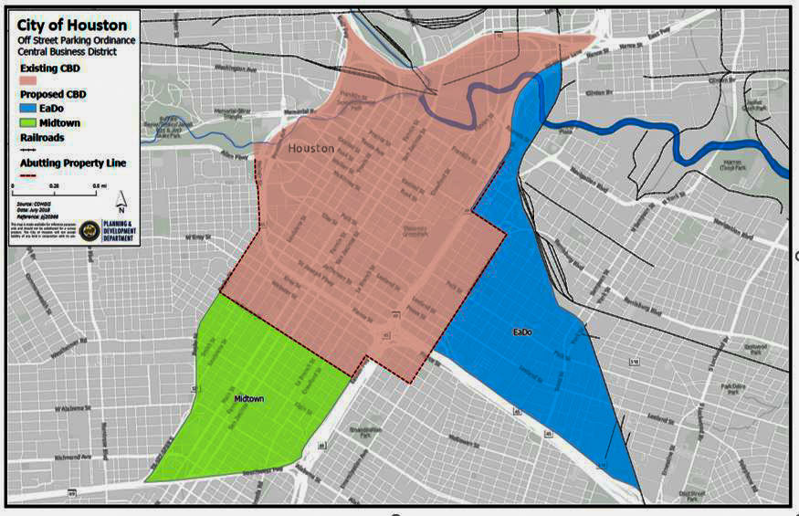
Of all the changes the Planning Dept. has in mind for Chapter 42 — the ordinance that governs development in the city — perhaps the most dramatic is the one that moves the city’s “urban” boundary. Chapter 42 currently labels the area inside the 610 Loop as “urban,” and the area outside of it “suburban.” The latest proposed draft would expand the “urban” zone all the way to Beltway 8. You’ll have to get past that to reach the burbs.
What do the urban and suburban designations mean? A lot of little things. And, perhaps, a lot of little lots: In certain circumstances, the proposed amendments would allow developers to subdivide “urban area” land into lots of less than 1400 sq. ft. and as narrow as 15 ft. wide.
Oh, but there’s a whole lot more to it than that.
***
Here’s the department’s summary:
Expanding the Urban Area – this amendment geographically expands the “urban area†to include all areas in the City Limits and within Beltway 8. The urban area designation allows for reduced building line requirements for certain developments along major thoroughfares with a designated width of less than 80 feet, certain single family residential developments and garage setback lines. It also allows for the use of lot size performance standards, reduced compensating open space requirements and the creation of shared driveways. The amendment expands the area eligible to seek Special Minimum Lot Size and Special Minimum Building Line status.
Guest Parking – New higher density single-family development provides only enough parking for the units. With the densification of the city, demand for curb parking is being increased due to multiple units on what used to be one single family lot, creating a lack of guest parking for the redeveloping areas.
The proposed amendment requires one guest space for developments that contain more than six dwelling units and an additional guest parking space for every six dwelling units in excess of the first six. Existing on-street parking in front of the development counts toward fulfilling the total parking requirement. It also identifies standards for a reserve restricted to parking.
Existing Conditions Survey – This amendment identifies the information required in a site survey for each subdivision plat with single-family residential uses.
Building Line Encroachments – This amendment specifies the type of encroachments allowed into a platted building line of 10 feet or greater.
Key Points to the amendment are as follows:
- An encroachment of up to 30 inches is allowed for eaves, bay windows, balconies, fireplace chimneys or decorative features that are cantilevered into the setback line.
- An encroachment of up to 5 feet is allowed for open stairways or wheelchair ramps into the building setback line.
Name Requirements for Partial Replats – Neighborhoods are concerned that a new replat name will remove the property from their deed restrictions. To insure name continuity, new applications for partial replats of single family residential subdivisions contain separately filed deed restrictions must be sequentially numbered referring back to the original plat name. For example, the first partial replat of “Sunny Land Subdivision†would be named “Sunny Land Subdivision partial replat no. 1.â€
Notification Requirements – This amendment expands the notification area for replats requiring notification under State Law, as well as applications requesting a variance or special exception to the standards of Chapter 42.
Key Points to the amendment are as follows:
- All property owners will receive a notification letter by U.S. Mail that are:
- within a 200-foot radius of the plat boundary; and
- abutting any street or private roadway extending 500 feet from the plat boundary
- Notification Signs posted on the property will be required to update the date, time and place of the next meeting where the Planning Commission will consider the application should the Commission’s action on the item be postponed for any reason.
- Notification Signs posted on the property will be required to identify the proposed land uses of the property, if known.
Average Lot Size/Average Lot Width – The current provisions of the code are based upon a 1970 style townhouse product. The purpose of these amendments is to allow greater flexibility for a mix of housing prices within a subdivision in the urban area while maintaining the compensating open space requirements.
Key Points to the amendment are as follows:
- Allowing for lots less than 1400 square feet if the average area in the block face is a minimum of 1400 square feet.
- Allowing for a minimum lot width of 15 feet if the average width in the block face is a minimum of 18 feet.
- Allowing for the averaging of building coverage performance standards for lots within the blockface.
There is a provision that limits the maximum lot width to 30 feet for averaging both lot width and area. This was added to prevent skewing the lot sizes to the minimums by using an oversized lot for averaging purposes.
These amendments are not applicable in established minimum lot size areas.
Sign Posting Requirements for New Single Family Residential Subdivisions which contain Certain Reserves – This amendment requires the posting of signs on reserves advising the homebuyers of the proposed future use of those tracts. Each sign must be posted before any single-family lot may be sold and must remain until the reserve is developed or the last lot is sold and developed.
The provisions of this amendment do not apply to landscape reserves, park or open space reserves, compensating open space reserves, drainage or detentions reserves, or recreational reserves.
Shared Driveways – Concerns about fire protection, access and turning movements and the adequacy of the width, length, geometrics and minimum setbacks adjacent to shared driveways for fire fighting purposes led to amendments related to the shared driveway provision for residential development inside the Urban Area.
Key Points to the amendment are as follows:
- Establishing a minimum shared driveway width of 18-feet with a 3-foot building setback line for most situations.
- Allowing for minimum shared driveway width of 16-feet with a 4-foot garage setback line in certain situations.
Lift Station Reserve Requirements – this amendment eliminates the conflict on the size of lift station reserves between Chapter 42 and the Public Works & Engineering Design Manual.
Key Points to the amendment are as follows:
- A lift station with one pump may have a minimum reserve size of 2,500 s.f.
- A lift station with two pumps may have a minimum reserve size of 3,750 s.f.
- A lift station with more than two pumps may have a minimum reserve size of 5,000 s.f.
If you want even more detail, see the latest version of the actual draft (PDF). A public hearing on the amendments is being crammed into the planning commission’s regular meeting Thursday afternoon.
- Notice of Public Hearing and Summary of Amendments to Chapter 42 (PDF) [Planning & Development]
- Chapter 42 Amendments Internal Draft 06/02/2009 (PDF) [Planning & Development, via GHPA]
- Code of Ordinances [Municode]
Urban border photo: Flickr user fishjam
It can take months for blocks to go through the process of petitioning and applying for minimum lot size and minimum building line provisions, not to mention the time it takes to move the applications through the Planning Commission and approved by City Council.
Neighborhoods outside the Loop who are eligible for these protections and want to preserve their lot size and building line character better start working on them now! The info is on the Planning Department website, http://www.houstonplanning.org.
The good thing is the guest parking requirement. Rice Military and Cottage Grove are experiencing the problems of lack of parking currently.
Legally a single lane of a street can be used to park on narrow streets. The problems arises when people along the length of the street utilize both sides. Then drivers need to zig-zag down the street. Not mention how metro buses have to deal with it.
The guest parking rule is one that doesn’t sit well with town home developers, but it is desperately needed.
The guest parking is fine. I could care less about parking because then maybe it will force people to use the metro and force the city to serious expand their rail line to go everywhere so that we don’t have to use a car. But for expanding our inner city to beltway 8 i don’t like it. Areas from 610 to the beltway are generally ugly and sketchy. I prefer the snobby feel people have living inside the loop. there won’t be that living inside the beltway. To us inside the loop it will still be the burbs.
Oh yeah, the TWELVE LANE intersection of Westheimer and Gessner surrounded by huge shopping centers, gasoline stations, parking lagoons,and fry pits feels so urban that I often think I’m in midtown Manhattan.
Yose,
The rail line will never go everywhere and will always serve a very minuscule portion of the population.
Never say that Houston is not “developer-friendly” although of course it always has been with or without ordinances that have never been enforced and never will be.
With a little money here and there, here and there at City Hall, a developer has always been able to do what he wants.
The exception of course being Buckhead Investment which found itself confronting a mayor who put the future political support of a law firm ahead of ethics with regard to enforcement of ordinances. Although with regard to 1717 Bissonnet, it was more a matter of attempting to create an ordinance to enforce.
_________________________________________
Neighborhoods outside the Loop who are eligible for these protections and want to preserve their lot size and building line character better start working on them now!
__________________________________________
They should. Unfortunately most probably won’t.
Chapter 42 and the proposed Urban Corridors ordinance should work as complimentary and parallel, because the first also requires the support infrastructure and amenities that the second is intended to create.
Some of the Urban “subdivisions” built inside the 610 Loop in accordance with Chapter 42’s residential parameters over past 10+ years are very successful because infrastructure was either already in place or was improved to support the increase in density.
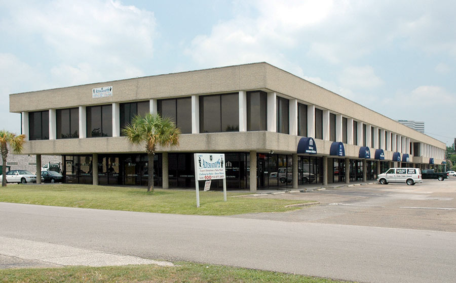
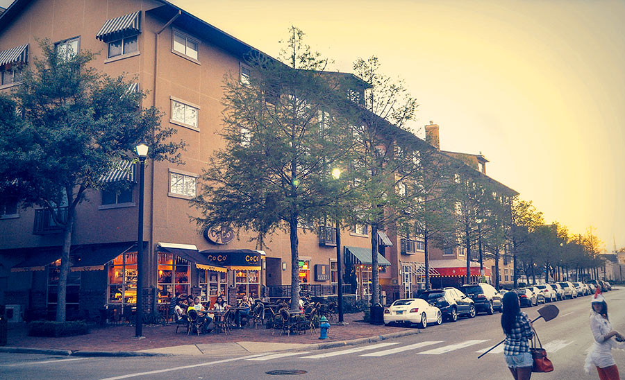
New residential density added in Midtown fronts wide streets with reasonable pedestrian realm, sufficient parking, preserved and newly created green spaces, and even mature shade trees. But, some are less successful in terms of adequate infrastructure and public amenities. In Superneighborhood 22’s west end – Rice Military and Cottage Grove – most urban “subdivisions” tend to be infill developments that have subdivided one or more 50 X 100 foot lots to each accommodate two or three single-family residential units with a minimum lot width of 20 feet.
Typically these subdivisions are on narrow streets that may have open swales for stormwater management and have very little space for the many functions public rights-of-way must serve – parking, trash bin staging, utility lines, poles and transformers, space for street trees and pedestrians.
Here, where infrastructure and amenities are inadequate to support the urban density that has been imposed, no Urban Corridors ordinance is proposed to provide improvement.
Allowing reduction of the minimum lot width to 15 feet, if an average lot width of 18 feet is maintained within the subdivision may be reasonable and desirable in terms of providing a diversity of residential style and price in large-scale developments, where an aesthetic mix can be achieved, and where infrastructure and amenities are incorporated into the plan for the benefit of the residents.
But, think about how this reduced lot size might work and what the cumulative impact would be of applying this one-size-fits-all regulation with 15 and 18 foot wide lots to multiple, small, infill “subdivisions†in neighborhoods where infrastructure and amenities are already less than adequate.
If this thought causes concern – inside the Loop or inside the Beltway. If your neighborhood has no deed restrictions, and your block has not petitioned for and received minimum lot size and set-back protection, this would be the time to put that process in motion.
There are two remaining opportunities, before these amendments are voted into law, for citizens to comment at public hearings.
Next up is the Regulation, Development and Neighborhood Protection Committee, Chaired by Council Member Toni Lawrence on Monday, June 22 at 3PM (verify the meeting time, previously this committee has met at 10AM) in the City Hall 2nd floor Council Chamber.
Council Members serving on this committee are:
Sullivan, Adams, Brown, Clutterbuck, Holm, Johnson, Jones, Lovell, Noriega and Rodriguez
The City Council hearing and vote will be early in July.
Any time developer friendly City Planners under a developer friendly Mayor, give the public less than 2 weeks notice before receiving public comments (6/2/09-6/11/09), I get very suspicious.
One glaring problem that I see with this change is that we already flood with the slightest rainfall, so a permeable area requirement was added. Guess what! Now each plat must have 150 sq. ft. per lot and cannot cover more than 75% of a lot less than 3500 sq. ft. OK, that’s good, but what happens on a 6000. 8000, or 10000 sq.ft. lot? Still only 150 sq.ft. of permeable surface? The rewrite is full of holes that can be exploited, but worse is that there’s intentionally no time for neighborhoods to realize the impacts, read the new documents (lots more changed than just Chapter 42), understand how they interact, and make constructive comments. City Council will vote on this July 1st or July 8th. Is this the Mayor making good on promises?
Turning Houston into a heat island of concrete is not creating a sustainable community. What it has a high probability of doing is increasing impermeable surfaces that will cause increased flooding, erases the green canopy, and creates very dense areas that lack the supporting infrastructure. Done right, increased urban density can be a good thing. Done wrong, it will be disastrous. Slow down, let the public really review the changes, see if there are requirements for improvements in infrastructure — drainage, water supply, etc. — then make the needed changes to do this correctly. Please!
Flood Victim; you have my vote, should you run for mayor.
Flood Victim, mine too. I put in my street’s combined MLS MBL petition the first week of May. A planner called today to let me know they have begun processing it. Yeah, the minimum lotsize is 3000sf, and by itself that would not give us a whole lot of protection, but coupled with the minimum building line, it becomes much more unattractive to developers.