
GOOGLE’S MAP OF HOUSTON’S INTERESTING PLACES 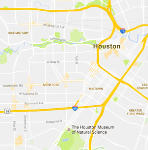 The light smudges of orange seen here are some of Google Maps’ latest updates to its slow digital document-everything push: highlighted areas of interest, based on density of retail and dining options. A glance around the new map, which rolled out late last month, reveals a fair amount of orange shading in strips and spots from Downtown west toward the Galleria and out along the Westheimer corridor, with bits of color appearing around Heights hotspots and the Rice Village area, among others. The areas east and north of the city’s center, however, are notably barren by Google’s accounting; Kyle Shelton writes that “This doesn’t, of course, mean that no activity occurs. It means the algorithm Google used did not register the form of activity that predominates there: more isolated shops and businesses spread among homes, along roadways or next to larger industrial tracts. What are the consequences of Google Maps, a visible, popular product showing that no areas of interest exist in these areas? How might that designation affect the bottom lines of businesses not within a hub?” [Urban Edge via Houston Chronicle] Map of Houston Areas of Interest: Google Maps


Google Maps is a good example of what happens when you can’t leave well enough alone. Lower contrast = harder to read; Special highlighting = unnecessary clutter; auto zoom in = missing the point of putting a location in context of its surroundings….and so on and so forth.
Places like Moon Tower, Neils Bahr, Voodoo Queen, and (The New) The New Potato have the right amount of people. I’m sure the owners want more but i like the neighborhood feel to these places.