From the website of New York graphic-design office Thumb:
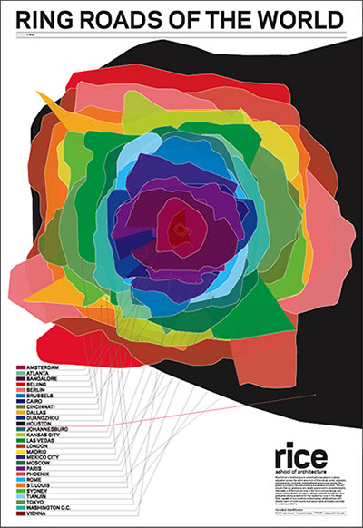
This poster is designed as a sort of calling card for Rice School of Architecture, located in Houston. We collected ring roads from 27 international cities and layered them all at the same scale. As it turned out, Houston has the largest system of those we surveyed. (Beijing was second)
- Ring Roads of the World [Thumb]
Poster: Thumb


I want one! Are they available for purchase?
which ring road does the outline represent? It certainly doesn’t represent the beltway and to call either highway 6 or grand parkway a ring road at this stage would be a bit of a stretch wouldn’t it?
I would like to purchase one too! Where are they selling them?
Looks like they used Highway 6 / FM 1960 as our ring road.
Gee.. that’s a nice fuzzy picture.. who would really want to be able to read it.?
Perfect example of utilizing visual representation to show a false message. Showing big ring road equates to big sprawl. Not a good correlation at all.
This picture would dramatically change if urban development extent is utilized instead. People thinking that Houston represents sprawl going nuts have no true knowledge of exactly how much sprawl other cities of the world have.
Paris and London make Houston’s suburban sprawl look like a compact city. Single family residential, strip malls, regular malls, and big box stores extend way further out in London. Paris has a massive suburban extent that would place Texas City and Lake Jackson as part of Houston’s suburbs. This also explains why they need lots of mass transit compared to Houston.
kjb434, you are reading a lot into this poster that isn’t there.
The message I get is that Houston (although smaller than several of these cities in population is better in size. From the source group, they view this as bad. My post earlier was to demonstrate the fallibility of their (potential) point.
kjb434: What is the deifintion of “better in size”? It sounds like you’re making a lot of assumptions about this poster that aren’t there. Many people would think smaller is “better in size”, others might think otherwise.
OOPS! I meant bigger in size. I’m trying to point out that the ring road doesn’t detail anything about the size of these cities. Several of these cities are much larger than the ring road.
What this poster does: overlays several ring roads to make a neat graphic, while startling viewers with the factoid that Houston has the largest one (is that Highway 6/1960? The Grand Parkway? Because if its the latter, it’s kind of a cheat since it hasn’t been built yet).
What the poster does not do: make any comment or claim at all on the size of the respective cities, whether measured in terms of population, square miles, city limits, metropolitan area, population density, etc., or make any comment or claim on where the ring roads are relative to the “edge” or the respective cities.
It’s SH 6 and FM 1960. The far northeast portion of the Houston shading is near Dayton, TX and the for southeast part of the shading is near Santa Fe or maybe as far at Texas City, TX.
Personally I would suggest that anything with traffic lights isn’t really a ring road, at that point it’s just a collection of roads that happen to ring an urban area. Of course, using that definition even beltway 8 isn’t a ring road.
That’s the thing Jimbo: Is there a definition of Ring Road? I think it’s kind of understood what a Beltway mean. and Loop.
Now it doesn’t apply much anymore, but Dallas does have a Beltline Road (which never really is a freeway) that was the ring around much of the urbanized city.
According to Wikipedia (always kind of a risk), Hwy 6/1960 sort of qualifies as a “ring road”:
“Ring road may sometimes refer to a beltway-style road, but more commonly indicates a road or series of roads within a city or town that have been joined together by town planners to form an orbital distributor style road, but where the standard of road could be anything from an ordinary city street up to an expressway level.” (http://en.wikipedia.org/wiki/Beltway)
Obviously Hwy 6/FM1960 is not within a single town or city, but the intent seems to fit the definition above–except for the “orbital” part, as the “orbit” gets truncated in the East.
It’s sort of a fudge, but it works for the poster. It makes Houston look pretty badass!
Hey,
Throw in SH 146 on the east side from Dayton to Texas City and you have the eastern Boundary.
It’ll fit that definition actually nicely.
That definition does explain the Beltline Road around Dallas. It’s a mix of different types and doesn’t form a defined loop, but a series or roads that make their way around the city.
Granted it isn’t a single highway, but a glance at a State map reveals that San Antonio does have a ring of State Highways around it comprised of 46, 173, and 97. They’re definitely laid out as a ring, with no apparent intent of directly connecting medium-sized towns or county seats in the same orderly way as is the case throughout the rest of Texas. And this one is about 70 miles across, twice the diameter of the Hwy. 6/1960 “ring” around Houston.
I’ve always thought of SH 1604 as the ring road or San Antonio’s Grand Parkway, your ring road TheNiche makes just as much sense and does pretty much encompass the entire urban area.
I would hesitate as well to call the grand parkway our ring without counting similar roads elsewhere. Vienna, Austria has two ring streets: the Ringstrasse (rings the inner historic district) — you can ride the streetcar around it in less than an hour– and the Guertel (German for belt) that is further out. The subway went beyond the Guertel, which would have made it a better measurement. I think the Ringstrasse is the one shown here. There may have even been a third ring that I knew nothing of since I had no car while living there.
We are calling the Grand Parkway our ring road, YET!
In about 5-10 years it’ll be close to becoming the next ring around the Houston region.
The graphic, together with some common knowledge about other cities (Houston’s population is much smaller than Mexico City or Beijing) does imply a few things: a low urban density, an arrangement of distant communities that are linked not only radially to the city center but also circuitously to others, and an enormous challenge of making mass transit financially viable. It also implies flat terrain, and a lot of open space to build upon.
I wonder if instead of a radial or spaghetti bowl mass transit system if we should have separate nodes (the size of Vienna) with their own radii, so we avoid the Chicago problem of “can’t get there from here”.
This graphic is very pretty – a rose! Ring-rose.
Yet it puts Roger Miller in my head:
“Trailer for sale or rent… I’m a Man-of-Means by no means! a Ring of the Road…”
I contacted the Rice School of Architecture, and they are out of the Ring Road poster. However, the person who contacted me hinted that they may reprint them.
Great job!
Sugest: Plot the names in the same order of the rings: Viena first, Houston at last.
Plot a scale bar (miles and km, please).
Coment: Maybe the definition of Ring Roads exclude Houstom arc, or We could find another “winner”
TKS
Its a nice piece of academic lure. It is intriguing and made all of us think about these things- which is its true point.
Would it be more “honest” if it showed that one awesome student model from a crappy studio, like the schools that begin with C and P in NYC do on a regular basis?
My first reaction was: My Texas city of 200,000 has a ring road that is bigger than some of these! Why not make it circumference of ring road over population! Then we’d beat those Houston ding dongs who are always trumpeting that they are soooo special down there in that unbearable swamp city.
Then I realized…”Ha Ha! Made you think!”
That’s what Rice is good at doing. Good luck new Dean Sarah Whiting. Those are provocative shoes you will fill- and you’ll do it well.
It would be great to see which ring roads you are comparing for the cities. It appears that you are comparing the ring road around the central business district of some cities to the outer ring roads of other cities.
Houston has 3 established ring roads and 1 partial ring road and 1 emerging ring road. It appears that the emerging ring road was used for Houston and that the ring roads for many of the older cities.
Poor scholarship at best and outright fraud at worst.
oops should have said, “…and that the inner ring roads were used from many of the older cities.”