02/25/19 3:00pm

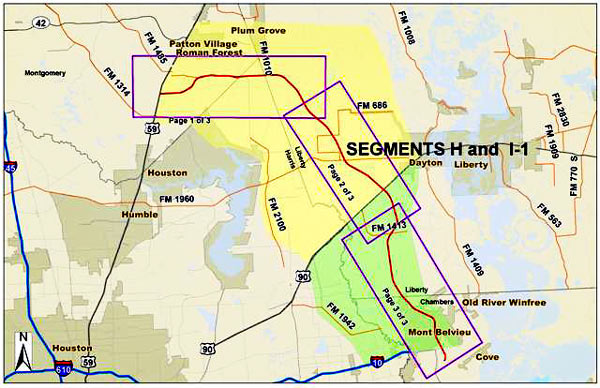
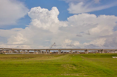
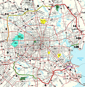
Here’s the latest roadmap of where the Grand Pkwy. currently exists (in green) and where it plans to go (yellow) as it assumes its full, 184-mile circumference. Construction on segments H and I-1 — which serve Liberty and Chambers counties — has been in progress since last year, although it wasn’t until last week that the federal government decided to chip in for it with a $605 million loan to the public nonprofit that’s behind the highway’s construction (a companion to the $840.6 million loan the feds arranged to fund the first 5 segments of the road). That’ll cover about a third of total $1.9 billion pricetag for the 2 northeastern segments, reports News 88.7’s Gail Delaughter. Construction on them is scheduled to wrap up in 2022.

Down south, work on segments C and B remains in the planning stage — and in the case of segment A, the indefinitely stalled stage. If TxDOT were to consider building that all-but-dead portion of the parkway between State Hwy. 146 to I-45 however, it could begin as far north as Kemah or as far south as Texas City.

Map: TxDOT

Rounding Out the Job
05/29/18 12:00pm

Within 3 miles of the Grand Pkwy.’s completed sections, more than 50,000 acres of development have sprung up in the past 5 years; they’re indicated by the pink patchwork in the map above, put out by Houston’s planning department. In following the highway, construction activity passes through 5 watersheds — Spring Creek, Cypress Creek, Addicks, Barker, and Brays Bayou — that aren’t seeing nearly as much concentrated development in non-roadside areas.

In order to plot out development across all of Harris County between 2013 and 2018, the map takes into account activity concerning “platting and general plans” over those years. That means the highlighted sections include parcels on which developers requested changes (for example, to merge adjacent properties or gain permission to build new types of structures), that often precede building.

Map: Houston Planning Department

Development Birdseye
06/09/16 5:15pm

B TEAM WANTS TO SEND THE GRAND PARKWAY WHERE THEY WEREN’T ALLOWED TO GO Proposed Grand Parkway Segment B
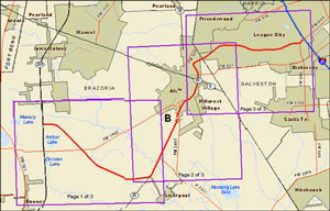
July 11th is the last day to make on-the-record comments about the route the Grand Parkway planners want to take from 288 to I-45 (known as Segment B of the 170-mile outer-outer loop). The finalized study documents published last week mention that proposed right-of-way runs across about 55 acres of wetlands — though that number isn’t precise: the document also mentions that the study authors couldn’t get permission to enter properties along 70 percent of the route, so the group had to use aerial photos to estimate. TxDOT’s desired route appears to hook in with SH288 at the intersection of CR 60 and follow the Brunner Ditch and South Texas Water Company canals southwest most of the way to SH35; from there it would swing back northeast just past Alvin, then eastward to hit I-45 where FM 646 does. [Previously on Swamplot]

05/18/16 11:15am

Plans for University of Houston Katy Campus, I-10 at Grand Pkwy., Katy, TX , 77449

On the agenda for tomorrow’s meeting of the University of Houston’s board of regents: a who-can-sign-for-it approval for the purchase of a 46-acre property in Katy, about a 10-minute drive from the 10-acre Cinco Ranch property the school is hoping to sell later this year.  The land occupies half of the big round tract at the northeast corner of I-10 and the Grand Pkwy. once slated to become Simon Property’s The Grand. That land was sold in 2014 to Moody-controlled Parkside Capital, which had been marketing it as a mixed-use office development called Verde Parc; if all goes according to the terms laid out in a late-April letter of intent describing the sale terms, the area will be rebranded as University Park (currently the name of the street the Cinco Ranch property sits on, at the intersection with S. Mason Dr.).

The Gensler site plan above appears in the notes that go along with tomorrow’s board vote; another aerial map clarifies that the University is buying the top half of the circle, not the bottom parcels:

CONTINUE READING THIS STORY

Campus Parking
01/05/16 12:45pm

Grand Parkway Segments H and I-1

The Army wants you to send the Corps of Engineers your thoughts on Segments H and I-1 of the Grand Parkway — if you can get them in order by February 1st. A public comment period, following some slight route revisions to the 37-miles-plus-a-bit-extra stretch of the in-progress outer-outer loop shown above in red, opened on December 30th. This next addition to Houston’s increasingly elaborate Saturn cosplay will run from 59 between Porter and New Caney through Montgomery, Liberty, and Chambers counties, skirting southeast of Dayton to link up with I-10 near Mont Belvieu.

Want to read up before having your say? The Final Environmental Impact Statement and associated documentation for the two segments, which collectively total 2,829 pages in pdf, have been helpfully split into 2 volumes for your perusing pleasure.

CONTINUE READING THIS STORY

Eastex Connections
12/22/15 9:45am

Spring Town Center, Kuykendahl Rd, Spring, TX 77389

38 miles of Grand Parkway are expected to open early next year — NewQuest Properties is prepping Spring Town Center for the anticipated additional traffic by adding five new pad sites to the retail complex, located off of Kuykendahl Rd. south of FM 2920. Grand Parkway Segments F-1, F-2, and G — running between US 290 and the Eastex Freeway — are kind-of-sort-of nearing completion following a flood-heavy 2015, and are expected open in the first quarter of 2016.

The new additions to the shopping center are highlighted in yellow in the map above, and the zoomed-in section below along Kuykendahl:

CONTINUE READING THIS STORY

Coming This Fall to Spring
03/03/14 3:30pm

Grand Parkway Segment D, Fort Bend County, Houston

The portion of the newly tolled Grand Parkway between U.S. 59 and US 90A (and a little further north, to FM 1464) quietly opened to traffic last Thursday. Segment D of the third or fourth ring road around Houston (depending whether you count the Hwy. 6 and FM 1960 combo), which extends about 18 miles from the Southwest Fwy. to I-10, has been open since 1994 — but mostly as a sleepy divided double-lane highway with a super-wide grassy median. The new tollway redo is being opened in spurts. The Fort Bend County Toll Road Authority, which controls this portion of Segment D, expects to have the complete stretch of tollway open between the Southwest Fwy. and the Westpark Tollway open by the end of April. When it opens, 7 automated toll booths will line that stretch.

Photo: Fort Bend County Toll Road Authority

59 to 90A and Growing
02/03/14 10:30am

From the self-described “guy with a quadcopter” behind Skyhawk Videos, here’s new aerial footage from high above the brand-spanking-new intersection of I-10 and Houston’s latest orbiting ringroad, the Grand Parkway. The view is primarily to the southeast, with a few tilts and glances in either direction; the new section of State Hwy. 99, aka the Grand Pkwy.’s Segment E, begins in the upper right of the initial image and extends to the lower left, across the Katy Prairie to the outlet mall in Cypress, running over an ancient burial ground in the process. The highway is carrying the last of its free traffic; tolls kicked in on Friday, about a month and a half after the segment opened and just a few days after Skyhawk’s drone shot.

In the lower right of the image is the new 151,600-sq.-ft. Katy Costco and gas station, scheduled to open to the public this Thursday. Its 14-acre site is the focus of its own separate video as well, filmed on January 25th:

CONTINUE READING THIS STORY

Grand Parkway, Costco, Cars!
12/16/13 12:00pm

WHERE THE ACTION IS, IN AND AROUND HOUSTON Map of Grand Pkwy. SegmentsFrom Dug Begley’s report on next weekend’s dual openings of the North Line light-rail extension and the Hempstead-to-Katy Segment E of the Grand Parkway: “[Judge] Emmett frequently notes that about 500,000 people live within Loop 610, about 1.5 million live between Loop 610 and the Sam Houston Tollway and about 2 million live outside the tollway within Harris County. ‘We’re seeing a lot of people moving inside the Loop,’ Emmett said. ‘That growth is going on. But for every person moving in, about four people are locating outside the beltway. Nothing is going to change that growth pattern.” [Houston Chronicle ($); previously on Swamplot] Map: Grand Parkway Association

07/18/13 12:00pm

FEEDING NEW APARTMENTS TO THE GRAND PKWY. FEEDER Austin developers Oden Hughes say that they have been eager to build in Houston, but the company’s first project here has come only as far east as Katy: A 354-unit apartment complex is going up a few miles east of Katy Mills Mall on 14 acres at the southwest corner of Kingsland Blvd. and the southbound Grand Pkwy. feeder. The Rancher reports that rent here at the so-called Parkside Grand Parkway will range between $850 and $1,655 a month for the complex planned to include 2 pools, a fitness center, and “an air-conditioned dog washing station.” [The Rancher] Rendering: Oden Hughes

04/11/13 12:30pm

Next month, reports Real Estate Bisnow’s Catie Dixon, construction’s supposed to start on 3 more segments of the Grand Parkway: That’s why F1, F2, and G on the map here are colored in that cautionary yellow. And where G ends? Not coincidentally, adds Dixon, at that future intersection with U.S. 59, planned to be completed by 2015, the 1400-acre master-planned Valley Ranch is getting ready to sprawl out.

CONTINUE READING THIS STORY

01/04/13 10:28am

Last month, Cite magazine editor Raj Mankad hiked 8 miles through the Katy Prairie to see the prehistoric human remains found during the construction of Grand Parkway’s Segment E for himself. He brought back a few photos and an essayist’s-eye-view of the archaeological saga:

It appeared as if TxDOT had aimed the 15-mile-long highway segment directly at the burial ground. The highway was suspended, figuratively and physically, like an unintentional monument honoring the burial grounds, like Texas was trying to tell anyone in an airplane or spaceship to LOOK HERE. . . . What I saw were several pieces of plywood, propped up on five-gallon paint buckets, covering what I presume to be the human remains and the tools, buffalo teeth, and other objects found with them. The plywood was weighted down with rocks. . . . To my amateur eyes, the excavation looked makeshift and tenuous, not systematic or professional.

Photos: Brett Sillers

12/05/12 1:44pm

COMMENT OF THE DAY: ALSO, PAVING OVER THEIR ANCESTORS “Yes we do know what people were doing 10,000 years ago. Basically it’s the same thing we are doing today. Making and raising children, trying to feed our family, and working to have safety, shelter, and clothing.” [Bill, commenting on Grand Parkway Will Pile on the Dead]

12/04/12 2:02pm

GRAND PARKWAY WILL PILE ON THE DEAD An agreement between TxDOT, the Harris County Historical Commission, and 5 Native American tribes over what to do with the prehistoric human remains unearthed in the prairie highway’s path will allow construction of the Grand Parkway Segment E to continue — with only a bump in the road: “Under the agreement, TxDOT will fill the excavated areas and cover them with rip rap, creating a permanent burial site near where the road would cross Cypress Creek, about three miles south of U.S. 290.” The reburial might confuse future anthropologists, though: “[UH professor of anthropology Kenneth] Brown expressed frustration over TxDOT’s handling of the site, saying crews saved some artifacts but ruined the area for richer study. The agency’s crews scraped and sifted mechanically instead of digging by hand. ‘When you scrape, you will find things, but you won’t be able to see how they were associated,’ Brown said. ‘That is a shame because we do not know what people were doing 10,000 to 14,000 years ago, and we won’t know now.'” [Houston Chronicle; previously on Swamplot] Photo of gravesite: abc13