A LAWSUIT OVER RIVERSTONE’S VANISHED LEVEE  More than 400 residents of Fort Bend County’s Riverstone development — between Hwy. 6 and the Brazos River — are suing the engineering firm that designed their stormwater systems, alleging that the design left one portion of the community flooded by the runoff from the other during Harvey. The roughly 3,700-acre area is divided into 2 Levee Improvement Districts — LID 19 (shaded blue on the map) and 15. “It became very clear when we passed into LID 15 that something was not right,” one LID 19 homeowner said in a press conference. “We were inundated with water in our neighborhood, and just on the other side of the street everything seemed to be perfectly fine.” Both LIDs were designed by Costello, Inc. the company founded by Houston’s flood czar Steve Costello. (He’s said he divested from it in 2015.) That firm’s failure to consider what would happen when a levee that ran between the 2 districts — along Hagerson Rd. — was removed is what downstreamers say is to blame for much of their soggy state. In total, reports the Chronicle’s Rebecca Elliott, about a third of the 1,760 homes in LID 19 flooded. [Houston Chronicle] Map of Riverstone LIDs 15 and 19: Riverstone LIDs
Sign up for the Newsletter
Fort Bend County

IN THE MISSOURI CITY AIR  Wild West Well Control is expected to finish capping an oil well this evening on McHard Rd. just west of the Fort Bend Tollway that blew out last night, sending foul-smelling fumes southeast into Fort Bend County. Nearby residents got a nose-ful: “Winds carried the smell across a large portion of the area; it is believed that the smell was from hydrogen sulfide. Total Fire has been conducting air monitoring in the area and has been unable to detect significant amounts of the chemical in the air.” [Fort Bend County OEM]
Photo: Fort Bend County OEM
Wild West Well Control is expected to finish capping an oil well this evening on McHard Rd. just west of the Fort Bend Tollway that blew out last night, sending foul-smelling fumes southeast into Fort Bend County. Nearby residents got a nose-ful: “Winds carried the smell across a large portion of the area; it is believed that the smell was from hydrogen sulfide. Total Fire has been conducting air monitoring in the area and has been unable to detect significant amounts of the chemical in the air.” [Fort Bend County OEM]
Photo: Fort Bend County OEM

HOW IT CAME TO PASS THAT HUNDREDS OF FAMILIES PURCHASED HOMES INSIDE HOUSTON’S RESERVOIRS  Many of the flooding victims upstream of Addicks and Barker dams learned for the first time that their homes were inside government-designated reservoirs only after rains from Harvey flooded their neighborhoods, reports Naomi Martin. How had they come to live there? “The corps didn’t feel the need to acquire all the land at the time the reservoirs were built, [the Army Corps of Engineers’ Richard] Long said, because that land was nothing but rice farms and fields where cattle grazed. It didn’t stay that way. In 1997, developers came before Fort Bend County government for approval to put subdivisions on the pastures. Aware of the flood risk to the area, the county was in a bind. It didn’t have the authority to prohibit development or establish zoning rules, said County Judge Robert Hebert, who has been in office since 2003. So the county insisted, ‘over great objection’ by developers, on including a warning on the plat, Hebert said. The county, he said, ‘felt it was a defect on the land that should be pointed out.'” The warning appeared as a small note on the plat document establishing some later Fort Bend County subdivisions, but equivalent declarations were absent on documents establishing nearby Harris County subdivisions. [Dallas Morning News] Aerial view of flooding in Canyon Gate, Cinco Ranch: Michael Fry

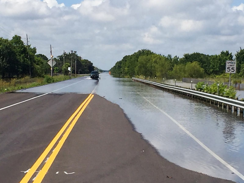
7 DAYS OF HARVEY BEFORE THE BRAZOS RIVER REACHES ITS SUGAR LAND PEAK  It wasn’t until early this morning that the Brazos River in Sugar Land and Richmond reached its highest level since area flooding triggered by Hurricane Harvey began. And it was a new record, reached at 5:15 am: 55.19 ft., according to the National Weather Service. The previous record, 54.7 ft. — surpassed Thursday at 1:30 am — was set by a flood last year on
 Tax Day June 2nd. The photo here shows the river during a rare moment of sunshine a day earlier than that — from Hwy. 59 where Greatwood, Riverpark, Telfair, and Sugar Land Memorial Park meet. [Houston Chronicle] Photo: Grace Carlson

YOUR BEST SOURCE FOR WILLOWRIDGE HIGH MOLD INFESTATION UPDATES  Curious about the extent of the mold found throughout Fort Bend ISD’s Willowridge High School this summer? Wondering if all the penicillium discovered on the campus at the tail end of Chimney Rock Rd. can be cleared out in time for the first day of school? As of today, there’s a new website for that: Check out this page for updates on remediation efforts; an accounting of band, JROTC, and athletic uniforms locked inside (they’ll be professionally cleaned); as well as a bit of backstory noting how investigators think the whole fungus fest began — after power was shut down in late June in advance of a planned construction project: “It is believed that the conditions outside (with increased humidity) combined with the fact that there was no A/C in the building factored into the rapid growth of the mold spores.” [Fort Bend ISD] Photo: Fort Bend ISD

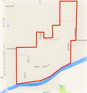 Residents of the Rio Brazos area near Cumings Rd. north of Rosharon are being advised as of this afternoon to boil their tap water until further notice, while the Fort Bend County Fresh Water Supply District 2 sorts out possible problems stemming from a flood-related loss of water pressure in the network. (The map included here has been added to the Fort Bend County emergency office’s Facebook page following a brief online outpouring of confusion as to what neighborhoods the warning was actually targeting.)
Meanwhile, TXDOT is still listing dozens of miles of roadways as covered by to high water as of this morning, with more closures expected as Brazos floodwaters drain southwest toward Angleton and Freeport. Here’s Brazoria County’s latest worst case scenario potential floodmap, with the county’s mandatory evacuation zones now stretching across more than 15 miles from roughly Brazos Bend State Park to the outskirts of Angleton:
Water, Water Everywhere


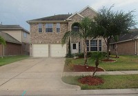
- 2010 Weatherby Ln. [HAR]


Is the sky really the limit when the neighborhood has its own landing strip, or is that what it takes for commutes from Richmond? That’s where a Covey Trails property,  located out FM 1093 near FM 1463, took off at $1.2 million in its listing over the weekend. Hangar (top) and hangouts (middle) are harbingers of the adventurous array — and many, many murals — found within the unassuming house, which previously kept its active inner life to itself. But now lookie here:
Over the Top

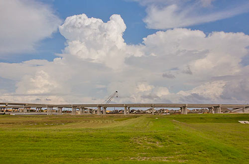
The portion of the newly tolled Grand Parkway between U.S. 59 and US 90A (and a little further north, to FM 1464) quietly opened to traffic last Thursday. Segment D of the third or fourth ring road around Houston (depending whether you count the Hwy. 6 and FM 1960 combo), which extends about 18 miles from the Southwest Fwy. to I-10, has been open since 1994 — but mostly as a sleepy divided double-lane highway with a super-wide grassy median. The new tollway redo is being opened in spurts. The Fort Bend County Toll Road Authority, which controls this portion of Segment D, expects to have the complete stretch of tollway open between the Southwest Fwy. and the Westpark Tollway open by the end of April. When it opens, 7 automated toll booths will line that stretch.
- Current Projects [FBCTRA]
- Remaining sections of Grand Parkway Segment D set to open by end of year [Impact News]
- Grand Parkway coverage [Swamplot]
Photo: Fort Bend County Toll Road Authority
59 to 90A and Growing


- 1118 League Trace [HAR]

")
It would seem that tilt-wall technology is not just for office buildings in the suburbs — but war memorials in the suburbs too! Yesterday, the Sugar Land Parks Dept. and local members of the Tilt-Up Concrete Association (whose national conference is in Houston this year) dedicated this site in Sugar Land’s Memorial Park for the Veterans’ Memorial, designed by the same firm, Powers Brown, that’s engineering the 6-story Sierra Pines II in The Woodlands, thought to be the tallest tilt-wall building in Texas. If you’re into this sort of thing, you can see how the memorial was propped up into place, thanks to plenty of pics the Parks Dept. posted to Facebook:


What’s that glow on the horizon? Could it be flashing reflections of the sparkly and shiny finishes inside this 2003 home in Mission Bend? The highly polished property in the Keegan’s Ridge neighborhood appeared on the market last week; it has an asking price that’s just a dollar short of $200,000.

THE COVERED-UP HISTORY IN THE FORT BEND COUNTY COURTHOUSE BASEMENT  Renovations to restore as much as possible of the 1908 Fort Bend County courthouse, standing at 500 Jackson St. in Richmond, have revealed a couple of surprises from the building’s past, reports the Sugar Land Sun: “Beneath the building’s carpeting was finely-made Italian Terrazzo flooring, dating back to the courthouse’s original construction. . . . While installing the building’s electrical system and sump pump in its basement, a walled-up room with glazed tile was uncovered. [Director of Facilities Management Don] Brady said the hidden room is likely a segregation-era restroom for African-Americans.” [Sugar Land Sun] Photo: Terry Jeanson


That slow-to-develop retail district on the old prison farm in Sugar Land, rehabilitated into The Crossing at Telfair, appears to be locking up a new occupant. This sign, says the reader who snapped the photo, recently popped up behind the Whataburger and the H-E-B on Hwy. 6, just to the north along University Blvd. of the site where that new 6,500-seat performance hall is planned to be built. No opening date for the Austin Tex-Mex chain has been announced, though the Sugar Land Sun reports that the place should be good to go by the end of the year.
- The Crossing at Telfair [Rubicon Realty]
- Houston Area Locations [Chuy’s]
- Chuy’s to open Sugar Land Telfair location by end of 2013 [Sugar Land Sun]
- Previously on Swamplot: What Sugar Land’s New Performance Hall Might Look Like, Sugar Land Officially Released from Prison
Photo: Swamplot inbox

")
Here’s a look at the recently approved designs of the new arts and concert venue that could start being built as soon as 2014 in Sugar Land. Drawn up by Washington, D.C., firm Martinez & Johnson, the 200,000-sq.-ft., 6,500-seat theater will eventually sit on 39 undeveloped acres in Telfair, just off the Southwest Fwy. and University Blvd.
