A LAWSUIT OVER RIVERSTONE’S VANISHED LEVEE  More than 400 residents of Fort Bend County’s Riverstone development — between Hwy. 6 and the Brazos River — are suing the engineering firm that designed their stormwater systems, alleging that the design left one portion of the community flooded by the runoff from the other during Harvey. The roughly 3,700-acre area is divided into 2 Levee Improvement Districts — LID 19 (shaded blue on the map) and 15. “It became very clear when we passed into LID 15 that something was not right,” one LID 19 homeowner said in a press conference. “We were inundated with water in our neighborhood, and just on the other side of the street everything seemed to be perfectly fine.” Both LIDs were designed by Costello, Inc. the company founded by Houston’s flood czar Steve Costello. (He’s said he divested from it in 2015.) That firm’s failure to consider what would happen when a levee that ran between the 2 districts — along Hagerson Rd. — was removed is what downstreamers say is to blame for much of their soggy state. In total, reports the Chronicle’s Rebecca Elliott, about a third of the 1,760 homes in LID 19 flooded. [Houston Chronicle] Map of Riverstone LIDs 15 and 19: Riverstone LIDs
Sign up for the Newsletter
Tag: Fort Bend County

HOW IT CAME TO PASS THAT HUNDREDS OF FAMILIES PURCHASED HOMES INSIDE HOUSTON’S RESERVOIRS  Many of the flooding victims upstream of Addicks and Barker dams learned for the first time that their homes were inside government-designated reservoirs only after rains from Harvey flooded their neighborhoods, reports Naomi Martin. How had they come to live there? “The corps didn’t feel the need to acquire all the land at the time the reservoirs were built, [the Army Corps of Engineers’ Richard] Long said, because that land was nothing but rice farms and fields where cattle grazed. It didn’t stay that way. In 1997, developers came before Fort Bend County government for approval to put subdivisions on the pastures. Aware of the flood risk to the area, the county was in a bind. It didn’t have the authority to prohibit development or establish zoning rules, said County Judge Robert Hebert, who has been in office since 2003. So the county insisted, ‘over great objection’ by developers, on including a warning on the plat, Hebert said. The county, he said, ‘felt it was a defect on the land that should be pointed out.'” The warning appeared as a small note on the plat document establishing some later Fort Bend County subdivisions, but equivalent declarations were absent on documents establishing nearby Harris County subdivisions. [Dallas Morning News] Aerial view of flooding in Canyon Gate, Cinco Ranch: Michael Fry

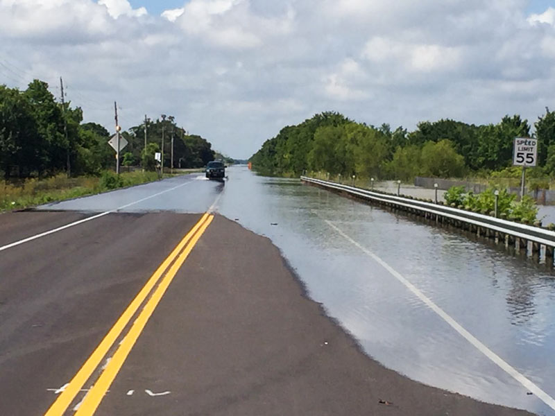
7 DAYS OF HARVEY BEFORE THE BRAZOS RIVER REACHES ITS SUGAR LAND PEAK  It wasn’t until early this morning that the Brazos River in Sugar Land and Richmond reached its highest level since area flooding triggered by Hurricane Harvey began. And it was a new record, reached at 5:15 am: 55.19 ft., according to the National Weather Service. The previous record, 54.7 ft. — surpassed Thursday at 1:30 am — was set by a flood last year on
 Tax Day June 2nd. The photo here shows the river during a rare moment of sunshine a day earlier than that — from Hwy. 59 where Greatwood, Riverpark, Telfair, and Sugar Land Memorial Park meet. [Houston Chronicle] Photo: Grace Carlson

YOUR BEST SOURCE FOR WILLOWRIDGE HIGH MOLD INFESTATION UPDATES  Curious about the extent of the mold found throughout Fort Bend ISD’s Willowridge High School this summer? Wondering if all the penicillium discovered on the campus at the tail end of Chimney Rock Rd. can be cleared out in time for the first day of school? As of today, there’s a new website for that: Check out this page for updates on remediation efforts; an accounting of band, JROTC, and athletic uniforms locked inside (they’ll be professionally cleaned); as well as a bit of backstory noting how investigators think the whole fungus fest began — after power was shut down in late June in advance of a planned construction project: “It is believed that the conditions outside (with increased humidity) combined with the fact that there was no A/C in the building factored into the rapid growth of the mold spores.” [Fort Bend ISD] Photo: Fort Bend ISD

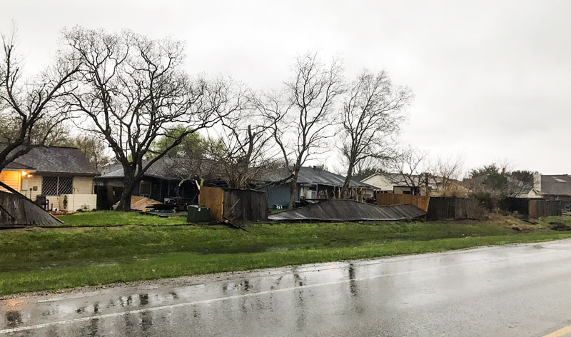
HISD and some of the southern swath of the Houston region have so far spent Valentine’s Day under a patchwork of school district shelter-in-place orders, this time in response to the tornado warnings that rolled through the upper Texas coast this morning (all since downgraded back to mere watch levels). A funnel did touch down near Needville around 8:30 and move roughly northeast toward First Colony, causing a number of structural rearrangements like the ones above (captured along Crabb River Rd. by the documentarians at the Fort Bend County sheriff’s office). The agency took a few more shots of the area’s roughing up:
Fort Bend Unfenced

GROUP PETITIONS FOR 13-COUNTY FLOOD PLANNING 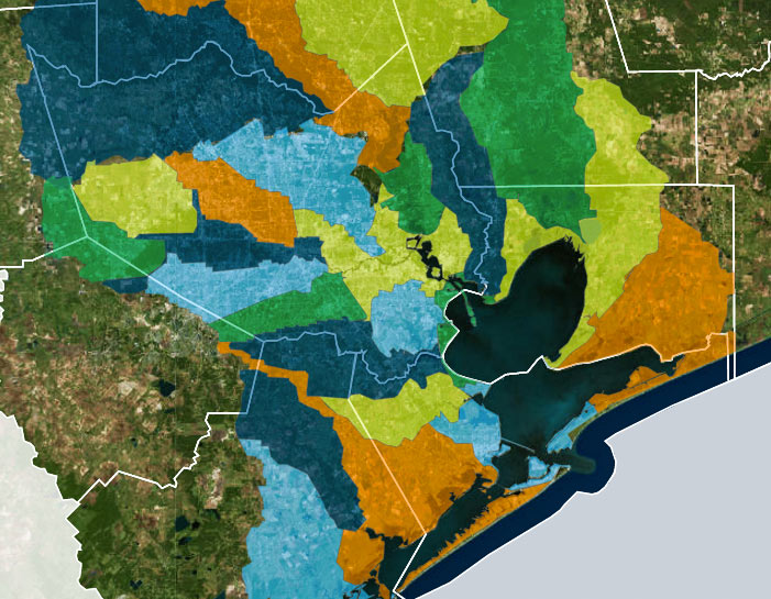 A group called Citizen Solutions to Flooding — not to be confused with the Residents Against Flooding group currently suing the city and TIRZ 17, though containing some of the same members — is circulating a petition calling for a region-wide plan to address man-made flooding issues, and an agency to oversee it. The petition lists out some of the specific technical concerns that signers want incorporated into future flood planning, including a shift from floodplain-level thinking to whole-watershed rules. The petition also calls for coordination across all 13 counties in the Houston-Galveston Area Council region; Citizen and Residents member Ed Browne tells Ed Mayberry that “flooding doesn’t know any boundaries. I mean, water doesn’t care whether you’re in Harris County or Montgomery County or Fort Bend. Unless we address the whole watershed, one area or another is going to suffer.† [Houston Public Media; previously on Swamplot] Watershed boundaries superimposed across Houston-area county boundaries: Galveston Bay Foundation and Houston Area Research Council’s Find Your Watershed map

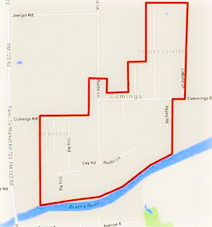 Residents of the Rio Brazos area near Cumings Rd. north of Rosharon are being advised as of this afternoon to boil their tap water until further notice, while the Fort Bend County Fresh Water Supply District 2 sorts out possible problems stemming from a flood-related loss of water pressure in the network. (The map included here has been added to the Fort Bend County emergency office’s Facebook page following a brief online outpouring of confusion as to what neighborhoods the warning was actually targeting.)
Meanwhile, TXDOT is still listing dozens of miles of roadways as covered by to high water as of this morning, with more closures expected as Brazos floodwaters drain southwest toward Angleton and Freeport. Here’s Brazoria County’s latest worst case scenario potential floodmap, with the county’s mandatory evacuation zones now stretching across more than 15 miles from roughly Brazos Bend State Park to the outskirts of Angleton:
Water, Water Everywhere

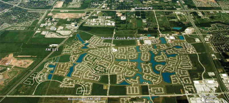
What could be causing the mysterious unpleasant odor Pearland residents have been reporting through TCEQ complaint channels since August of last year — primarily from the Shadow Creek Ranch subdivision (shown above) between 288 and FM 521 south of Clear Creek? TCEQ’s Andrew Keese spoke with the Houston Chronicle recently about the 26 previous and ongoing investigations, which are triggered whenever a finger is pointed at a new possible emitter of the smell. So far, Keese says, no odors have been officially detected that qualify as a ‘nuisance condition’, but he encourages residents to use the TCEQ’s odor log form to help the search effort by describing “the precise character of the odor, [relevant] weather conditions, and times” when the smell is noted.
Before you ask, yes: TCEQ knows about the 60-ft tall mounds of garbage right across FM 521 from the subdivision, at Republic Waste Service’s Blue Ridge Landfill (visible in the bottom left corner of the above photo as a pinkish blob).  Pearland residents previously sought to keep the landfill from more than doubling in acreage and nearly tripling in height (and blocking the operation of several Doppler Radar stations in the process). The landfill (which started accepting garbage several years before Shadow Creek Ranch’s developers broke ground nearby) will eventually get to pile as high as the 170 ft. allowed by its expanded TCEQ permit — but per a 2009 settlement agreement with the city of Pearland it will have to wait until 2021 before rising to only 130 ft., and wait another 8 years after that to reach for its full vertical potential.
Sniffing Out the Culprits in Pearland


- 2010 Weatherby Ln. [HAR]


Is the sky really the limit when the neighborhood has its own landing strip, or is that what it takes for commutes from Richmond? That’s where a Covey Trails property,  located out FM 1093 near FM 1463, took off at $1.2 million in its listing over the weekend. Hangar (top) and hangouts (middle) are harbingers of the adventurous array — and many, many murals — found within the unassuming house, which previously kept its active inner life to itself. But now lookie here:
Over the Top

Construction work has begun on the exciting new Sam’s Club #6867, which will face onto the Grand Pkwy. just north of Bellaire Blvd. in Richmond, as this reader photo taken from Parkway Lakes Ln. attests. The 136,454-sq.-ft. store will be surrounded by a sea of 529 parking spaces and 13 cart corrals on a 15-acre site just south of the Westpark Tollway:
@ Westpark Toll Rd.

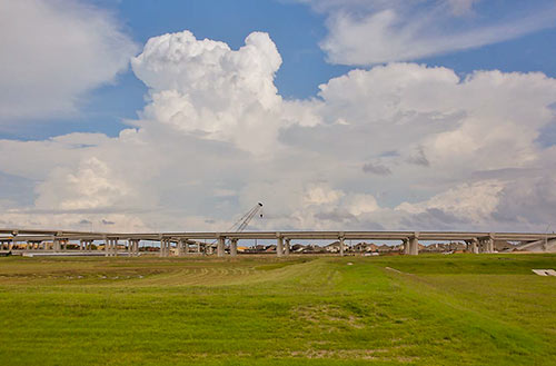
The portion of the newly tolled Grand Parkway between U.S. 59 and US 90A (and a little further north, to FM 1464) quietly opened to traffic last Thursday. Segment D of the third or fourth ring road around Houston (depending whether you count the Hwy. 6 and FM 1960 combo), which extends about 18 miles from the Southwest Fwy. to I-10, has been open since 1994 — but mostly as a sleepy divided double-lane highway with a super-wide grassy median. The new tollway redo is being opened in spurts. The Fort Bend County Toll Road Authority, which controls this portion of Segment D, expects to have the complete stretch of tollway open between the Southwest Fwy. and the Westpark Tollway open by the end of April. When it opens, 7 automated toll booths will line that stretch.
- Current Projects [FBCTRA]
- Remaining sections of Grand Parkway Segment D set to open by end of year [Impact News]
- Grand Parkway coverage [Swamplot]
Photo: Fort Bend County Toll Road Authority
59 to 90A and Growing


- 1118 League Trace [HAR]

")
It would seem that tilt-wall technology is not just for office buildings in the suburbs — but war memorials in the suburbs too! Yesterday, the Sugar Land Parks Dept. and local members of the Tilt-Up Concrete Association (whose national conference is in Houston this year) dedicated this site in Sugar Land’s Memorial Park for the Veterans’ Memorial, designed by the same firm, Powers Brown, that’s engineering the 6-story Sierra Pines II in The Woodlands, thought to be the tallest tilt-wall building in Texas. If you’re into this sort of thing, you can see how the memorial was propped up into place, thanks to plenty of pics the Parks Dept. posted to Facebook:


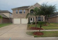
What’s that glow on the horizon? Could it be flashing reflections of the sparkly and shiny finishes inside this 2003 home in Mission Bend? The highly polished property in the Keegan’s Ridge neighborhood appeared on the market last week; it has an asking price that’s just a dollar short of $200,000.
