
GROUP PETITIONS FOR 13-COUNTY FLOOD PLANNING 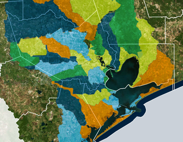 A group called Citizen Solutions to Flooding — not to be confused with the Residents Against Flooding group currently suing the city and TIRZ 17, though containing some of the same members — is circulating a petition calling for a region-wide plan to address man-made flooding issues, and an agency to oversee it. The petition lists out some of the specific technical concerns that signers want incorporated into future flood planning, including a shift from floodplain-level thinking to whole-watershed rules. The petition also calls for coordination across all 13 counties in the Houston-Galveston Area Council region; Citizen and Residents member Ed Browne tells Ed Mayberry that “flooding doesn’t know any boundaries. I mean, water doesn’t care whether you’re in Harris County or Montgomery County or Fort Bend. Unless we address the whole watershed, one area or another is going to suffer.† [Houston Public Media; previously on Swamplot] Watershed boundaries superimposed across Houston-area county boundaries: Galveston Bay Foundation and Houston Area Research Council’s Find Your Watershed map


Good for them! Our County Commissioners won’t address even simpler flood problem and this is a good effort to look toward a real solution – not an ego or dollars based solution. As gov’t does less and less and won’t respond to the citizens, we need to take collective action – this is a good step in that direction. Increasingly the counties do as little as possible – and only when under duress from the citizens. Thinking big, like this, is a step forward. It also recognizes that the State has failed in it’s duties to help cross-jurisdictional solutions.
Oh god no,
That’ll just create more flooding problems with a layer of bureaucracy.
“Citizens for Flood Planning” yet are likely deniers of climate change. Oh, the agony!
Abolishing arbitrarily-bounded entities (with taxing powers) like the HCFCD and instead creating entities that are specific to individual watershed seems like it might make some sense. I do worry that certain areas, especially less affluent ones, would suffer from poor or corrupt leadership; and you can’t simply merge watersheds as the TEA would merge school districts. However, that’d certainly be more democratic and accountable. That’s a trade-off which might be worth making.
TR-17 site (http://www.houstontirz17.org/) proudly announces 55 acres of water detension in the last 24 months. The problem is just the Memorial City complex is 236 acres according to Google Earth. That does not include the surrounding commercial and multi-family.
Remove all parking lots and replace with permeable grade (https://www.truegridpaver.com/) over a water collection network with water detention on the site. A few miles down the highway does not help the neighbors. Use the existing paving as granular fill.