
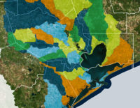
Within 3 miles of the Grand Pkwy.’s completed sections, more than 50,000 acres of development have sprung up in the past 5 years; they’re indicated by the pink patchwork in the map above, put out by Houston’s planning department. In following the highway, construction activity passes through 5 watersheds — Spring Creek, Cypress Creek, Addicks, Barker, and Brays Bayou — that aren’t seeing nearly as much concentrated development in non-roadside areas.
In order to plot out development across all of Harris County between 2013 and 2018, the map takes into account activity concerning “platting and general plans” over those years. That means the highlighted sections include parcels on which developers requested changes (for example, to merge adjacent properties or gain permission to build new types of structures), that often precede building.
- Development Activity in Houston and Watersheds [Houston Planning Department (PDF)]
Map: Houston Planning Department

 “. . . I think that if we are going to be realistic about the way that we finance flood control, that the core of such a plan needs to take a page from how flood insurance gets underwritten. Everybody pays a property tax to a watershed-specific flood control entity, but that tax is adjusted based on the elevation of their first-floor living area relative to the Base Flood Elevation. If you’re more than a few feet above it, your tax is very low. If you live more than a few feet below it . . . you’re probably going to pay so much in taxes that it’ll become immediately economic to raise your structure or demolish it. Right away, the inventory and value of property subject to flood risk is reduced; and what’s left that is tolerably at-risk pays for its own reduced need for risk mitigation. And . . . if we’re too gun shy to pull the trigger on a plan like this, which would totally wipe out a lot of people’s equity in vast swaths of real estate, okay well that’s where people not at very much risk should be expected to pay more taxes even without receiving very much in the way of benefits. Yeah, I’m basically proposing Obamacare for flood control in Houston, but only as a humane alternative which reveals a startling truth: that the big money for this sort of thing is unlikely to come from up on high, from the feds or the state government (and it shouldn’t IMO). Financing this stuff locally is going to hurt. One thing is very very clear: whatever kinds of administrative bodies are created or re-jiggered to deal with this issue have got to address legacy development first and foremost. We need a plan to cope with what is already on the ground. This is not something that we can just build ourselves out of, going forward, with stricter rules for new development, feel the catharsis, hold hands and sing Kumbaya, and call it a day.” [
 “Abolishing arbitrarily-bounded entities with taxing powers like the HCFCD and instead creating entities that are specific to individual watersheds seems like it might make some sense. I do worry that certain areas, especially less affluent ones, would suffer from poor or corrupt leadership; and you can’t simply merge watersheds as the T.E.A. would merge school districts. However, that’d certainly be more democratic and accountable. That’s a trade-off which might be worth making.” [
 A group called Citizen Solutions to Flooding — not to be confused with the Residents Against Flooding group currently