01/11/19 4:30pm

Budding internet etymologist and Albany High School senior Adam Aleksic is out with his latest annotated map (bigger version here), which points out the origins behind some of the Houston area’s most well-known neighborhood names. As you can see in the legend at the top right corner, the author makes a distinction between developers and people — both of which have left their marks in the region’s spacial vernacular. And of course, no map of Houston would be complete without its fair share of wet spots, too, which appear in the meanings behind 6 locations shown above: Lazybrook, Timbergrove, Spring Branch, River Oaks, Clear Lakes, and Denver Harbor.

Image: The Etymology Nerd

Words for Places
01/07/19 3:00pm

COMMENT OF THE DAY: THERE’S A BIG ORANGE ARROW OF DEMOLITIONS POINTING TOWARD DOWNTOWN “Play around with the zoom level on the map while centered roughly on the Galleria. What you find will shock you (or probably not if you’re a regular here).” [TimP, commenting on Every Houston Demolition of 2018, Mapped; previously on Swamplot]

01/03/19 3:00pm

It’s the most wonderful time of the year to take stock of everything that’s been ripped to shreds around town recently, so we built this tool to help you do so. The map above shows the location of every demolition permit filed with the City of Houston in 2018. Here’s a full-size version. In total 2,312 properties were tagged for demo, some of which — like, say, apartment or industrial complexes — saw multiple structures go down on their premises. Zoom in and you’ll see the clusters start to break down into individual address markers that tell you more about what went down. (Multi-building demos are indicated by the bullseye icons with multiple rings.)

Recognize any of last year’s high-profile disappearances? The Shelor Motor Company Building at 1621 Milam St., for instance? KHOU’s flooded newsroom at 1945 Allen Pkwy.? The Depression-era Harris County District Attorney’s Building at 201 Fannin, Clark Gable’s former house at 411 Hyde Park Blvd., the northeast portion of the River Oaks Shopping Center at 1958 W. Gray St., La Colombe d’Or’s ballroom at 3410 Montrose Blvd., architecture firm Caudill Rowlett Scott’s former HQ at 1177 West Loop South, Exxon Chemical’s old conference building at 13501 Katy Fwy., the mysterious Heights corner compound at 620 W. 9th St., Shake Shack’s Burger King predecessor at 1002 Westheimer, the last traces of KBR’s Fifth Ward complex at 2720 Clinton Dr., the bungalow at 610 Allston St. where Mary Cerruti — the homeowner who refused to make room for Trammell Crow’s adjacent Yale at 6th apartments — was found dead inside one of the walls?

They’re all there. This time, however, they’re sharing the spotlight with all their fellow, but significantly less fussed-over knockdowns, the kinds that form the bulk of Houston real estate turnover. For a look at where across-the-board demo activity was the most concentrated last year, take a look at our 2018 demolition heatmap:

CONTINUE READING THIS STORY

Annual Demolition Report
12/19/18 12:45pm

THE WOODLANDS EXPRESS HAS ARRIVED ITS REAL-TIME BUS MAPPING FUTURE Note: This story has been updated to indicate that METRO also has a real-time bus mapping app. Now you can know exactly how far your The Woodlands Express bus is from picking you up thanks to the township’s recently-released transit tracking service. The tool, powered by transportation mapping company Ride Systems, is accessible right now through The Woodlands’ mobile ticketing app (launched in August) and at this webpage — which indicates all Woodlands Express vehicles at as they proceed along their designated routes. (Things are a bit slow at midday compared to commuter hours.) METRO — which has nothing to do with The Woodlands’ in-house transit agency — released its own mobile ticketing app in 2016, as well as a companion app called METRO Trip that features live location data for its fleet of buses. [Community Impact] Photo of The Woodlands Express bus: The Woodlands Township

10/30/18 3:15pm

Add 6 more locations to the list of Mattress Firm stores the company has decided to close as part of its recent Chapter 11 filing. They are: across Hwy. 6 from the Missouri City H-E-B off Sienna Pkwy., at Baybrook Square across from Baybrook Mall (already home to Mattress Firm Final Markdown that’s sticking around for now), in the Oak Ridge North Shopping Center across I-45 from The Woodlands Mall, off 290 north of Spring-Cypress Rd., and in the Portofino Shopping Center off I-45 in Shenandoah. There’s also one closing within Houston proper: the 5409 S. Rice Ave. store, which fronts  the Walmart off 59. The map above shows all the closures — including standard locations (red), Final Markdowns (orange), and Clearance centers (yellow) — the chain has announced so far.

King-Sized Retreat
10/08/18 12:15pm

Twelve standard Mattress Firm locations (red) are going out of business, as well as 4 Final Markdowns (orange) and one Clearance-branded location (yellow). That’s 17 closures altogether, 2 shy of the number Mattress Firm announced would shutter across the rest of Texas when it filed for bankruptcy last week.

They are . . . on Westheimer near Hillcroft Ave., on I-10 in the Village Plaza at Bunker Hill shopping center, in Westgate Marketplace retail center off I-10 along N. Fry Rd., next-door to the other Mattress Firm in the Westmont Shopping Center at Westheimer and Montrose Blvd., on the W. Loop S. feeder road between Westheimer and Richmond, across Tomball Pkwy. from Willowbrook Mall, on Hwy. 6 north of Bissonnet, across from Baybrook Mall in Webster, in the Riverstone Shopping Center on Hwy. 6 in Missouri City, on 59 in Richmond near the beginning of the Grand Pkwy., in Sugar Land’s Market at Town Center shopping center next to First Colony Mall, at Pearland Town Center, across from the Mason Village shopping center in Katy, further south down S. Mason Rd. near Highland Knolls Dr. in Katy, on I-45 south of Robinson Rd. in Spring, at The Woodlands Mall, and on I-45 north of W. Davis St. in Conroe.

The Big Sleep
06/22/18 12:30pm

Here’s a nugget from the latest draft of Sugar Land’s 2018 land use plan: the map above, showing the 7% of acreage that still hasn’t been developed within the 32.2-sq.-mi. town and its roughly 20 sq.-mi. of extraterritorial jurisdiction. The thickest road running diagonally through the gray matter is the Southwest Fwy.; it’s intersected and then paralleled by Hwy. 90 to the north. Conspicuously blackened: the area on the top left edge indicating a tract west of Sugar Land Regional Airport and adjacent to the Chelsea Harbour subdivision off 90. There’s another vacancy along the Brazos River, way far south near FM 2759. And a few gaps show up between the hodgepodge of industrial buildings in the northeast corner of town.

A more detailed map below color codes what all that land — built and unbuilt — was used for as of 2016:

CONTINUE READING THIS STORY

Black Holes
06/20/18 10:45am

Now that a second, $51 million round of FEMA funding for home buyouts has come through, here’s the map of where the latest government snatch-ups are planned, 294 total. As indicated by the red dots above, they’re all outside the Loop — with a good portion grouped in 3 distinct clusters along Cypress Creek (which drowned out previous flooding records along nearly its entire length during Harvey). Other hotspots include several along White Oak Bayou, as well as a Greens-Bayou-adjacent bunch off Beltway 8 just north of Aldine and a San Jacinto River-side group south of Hwy. 90, near Highlands.

The money Harris County Flood Control District expects to receive for these purchases supplements an earlier $25.6 million FEMA committed to it on June 4. That previous check (along with an $8.6 million match the Harris County Commissioners okayed in order to get it) will be spent on about 169 buyouts, mapped out below:

CONTINUE READING THIS STORY

Along the Bayous
06/15/18 5:00pm

The results are in from the Kinder Institute’s recent survey of Gulfton sidewalks: where they exist, they’re in bad shape. The map above uses a stoplight-style color scheme to rank the condition of each segment: red means no sidewalks, yellow means they exist but with gaps, hazards, and other obstructions — and green means they’re good to go. (Black areas weren’t assessed by the 16 participant-observers who set out on foot to compile the study last month.)

Out of all charted segments, the worst is a 9-block corridor along Atwell St. that starts a block west of Burnett Bayland Park; it’s completely sidewalk-less between Elm St. and Bissonnet. In total, nearly 43 percent of the examined street segments lacked any kind of pedestrian walkway. Other side-ways where you might want to tread lightly include those along Chimney Rock — which is laced with trip hazards all the way from 59 down to Evergreen St. at the southern end of the neighborhood. Nearly three-quarters of the sidewalks in study fell into this category of disrepair.

Even the areas with smooth pavement were beset with other problems: 70 percent had almost no shade, and 98 percent had no pedestrian-level lighting. The consequences: between 2010 and 2017, 149 people were either killed or injured while walking through Gulfton, according to TxDOT data.

Map: Kinder Institute

Concrete Findings
06/07/18 9:45am

The final page of the Harris County Flood Control District’s final report on Hurricane Harvey includes the map above, with orange indicating where bayous, rivers, creeks, and gullies set new high water marks between August 25 and 29. Aside from Sims Bayou and a handful of smaller waterways, every other liquid landmark in the county outdid itself along some portion during the storm. Several — such as Cypress Creek and Carpenters Bayou (shown in detail above) — set new flood records along their entire lengths.

Less distinguished are White Oak and Little White Oak bayous, which broke records along only tiny stretches near Buffalo Bayou:

CONTINUE READING THIS STORY

Watery Award Tour
06/04/18 4:30pm

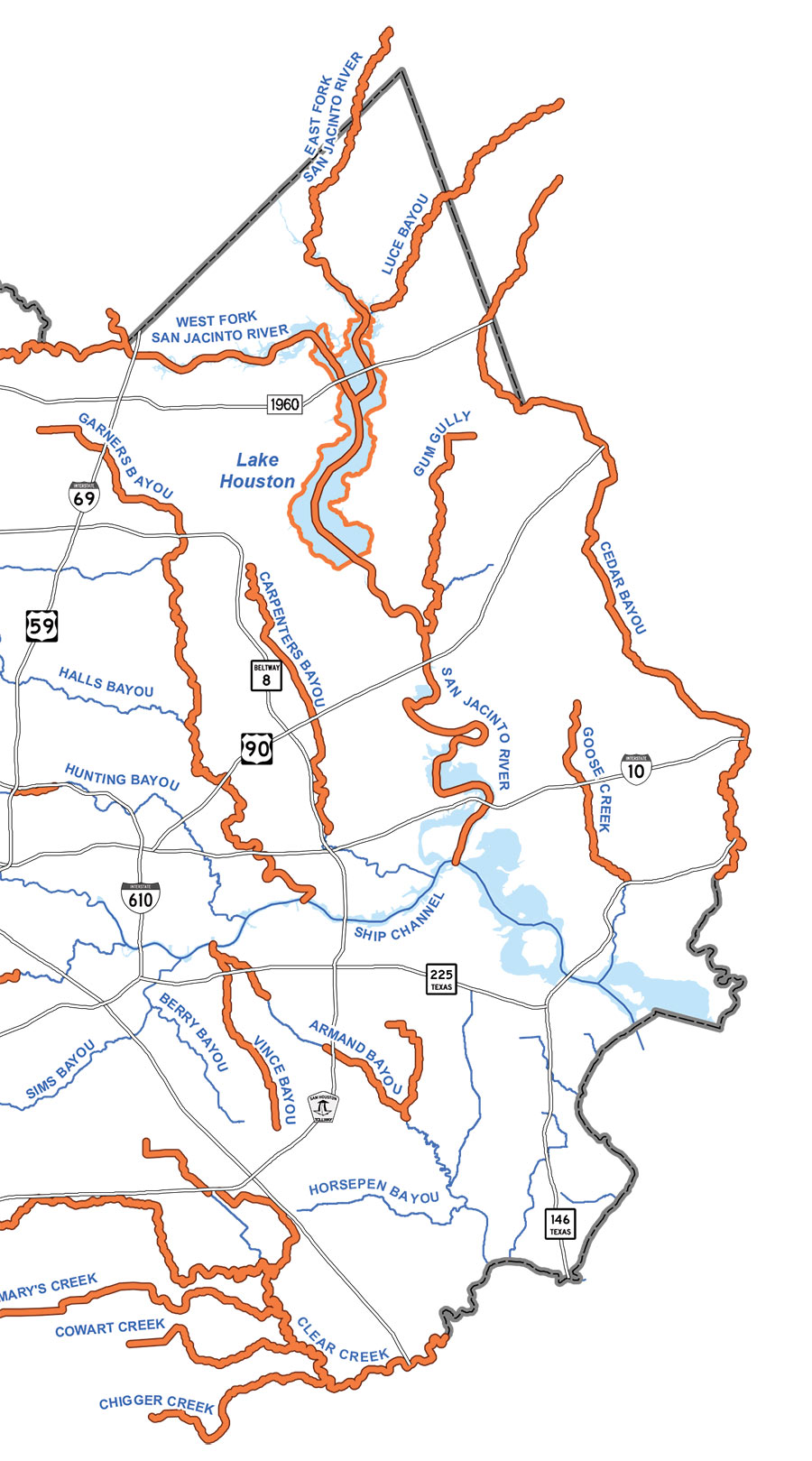
The map above — taken from this week’s city planning agenda — provides a candy-colored indication of how Midway plans to divvy up the 136-acre former KBR site along Buffalo Bayou, east of downtown, that it’s redeveloping into an office, retail, and residential neighborhood dubbed East River. Among the more colorful land uses revealed for the site: a park-fronting hotel slated for the semi-circular red parcel to the east, as well as a nameless museum — shown in grape — that’s planned along Buffalo Bayou near the neighborhood’s western edge.

Sprinkled along the water is an extension of the existing trail that runs along Buffalo Bayou’s north bank. It would traverse the entire development, from its western edge to the boat dock planned at its eastern boundary. Along the way, “Pedestrian bridges are being discussed with Buffalo Bayou Partnership to connect the two sides of the bayou,” according to the plans Midway submitted to the city.

Those 7 consecutive yellow blocks at the north end of the site along Clinton St. represent the citadel of townhomes that’ll look out onto the surrounding Fifth Ward. It’s bookended by 3 blocks of retail to the east along Hirsch Rd. and one to the west on Jensen Dr.

As heralded by the sign — pictured below — now hanging the site’s construction fencing, Houston’s city planning commission will take up the special exemption request that Midway submitted for the development later this week:

CONTINUE READING THIS STORY

Sweet Deal
05/29/18 12:00pm

Within 3 miles of the Grand Pkwy.’s completed sections, more than 50,000 acres of development have sprung up in the past 5 years; they’re indicated by the pink patchwork in the map above, put out by Houston’s planning department. In following the highway, construction activity passes through 5 watersheds — Spring Creek, Cypress Creek, Addicks, Barker, and Brays Bayou — that aren’t seeing nearly as much concentrated development in non-roadside areas.

In order to plot out development across all of Harris County between 2013 and 2018, the map takes into account activity concerning “platting and general plans” over those years. That means the highlighted sections include parcels on which developers requested changes (for example, to merge adjacent properties or gain permission to build new types of structures), that often precede building.

Map: Houston Planning Department

Development Birdseye
05/24/18 11:00am

Here’s the rundown of all the locations where vehicles injured (purple) or killed (black) cyclists and pedestrians in 2016 and 2017. Transit-focused organization LINK Houston used TxDOT reports to create the map, which plots out 85 percent of all the 641 major walk-and-bike crashes that occurred within city limits during those 2 years. (Locations for 15 percent couldn’t be nailed down.) Of all those collisions, just under a fifth involved bikers; the rest impacted pedestrians. Click on a dot to reveal more about the specific accident that happened at that location.

Even more data shows up here on the full-screen map, which tallies up demographics like the ages, races, and genders of those hit as you move around different neighborhoods. Citywide, one of the brightest constellations is an elbow-shaped one that stretches from Montrose through Midtown and into  Downtown — where 22 crashes occurred over the last 2 years. But despite its dimmer glow, Sharpstown had the highest hit rate of any Houston neighborhood: 29. Throughout the entire city, 158 people were killed and 389 were injured.

Map: LINK Houston

Hit Count
02/09/18 4:30pm

THE RIGHT DOORS TO KNOCK ON WHEN PETITIONING FOR LOT SIZE RESTRICTIONS This new map put out by civic-minded data miner Jeff Reichman shows only one thing: which Houston properties are owner-occupied according to HCAD data — they’re indicated in green. But Reichman is pitching it as a tool residents can use to figure out something more: how likely their neighborhoods would be to qualify for a minimum lot size restriction. Minimum lot size refers to the smallest square footage developers can chop lots into in order to cram more structures onto them — like, say, townhomes — than they could have previously. The Planning Commission requires neighborhood consensus in order to consider applications for size restrictions — in the form of a vote, but first in signatures from the owners of the lots in question. And to gather that ink, it’s helpful to know who’s home. The map at top (taken from a set of bigger ones showing entire neighborhoods) takes a look at several Third Ward blocks south of Blodgett St. that appear well-suited to the Planning Commission’s requirements because they have high rates of home ownership, and because their lots are already of similar size (70 percent of lots in a given area must be the same size for the Planning Commission to consider restrictions, which wouldn’t do much good if the properties’ dimensions were already inconsistent.) And look — the purple rectangle shows 2 block faces where restrictions are already in place, on Southmore Blvd. and on Palm between Sauer and Burkett. [January Advisors; more info] Map: January Advisors

01/30/18 4:15pm

“On almost any map that plots some form of wealth,” writes the Kinder Institute’s Leah Binkovitz, “a familiar arrow takes shape over the Energy Corridor, Memorial and River Oaks, pointing east toward downtown.” Nowhere is that arrow clearer than on this map from fitness brand Strava, which visualizes running and biking activity in Houston from 2009 through last October. Strava updated its map — which includes 200,000 years worth of global exercise time — in November (although it’s been in the news more recently than that). Beginning just east of Hwy. 6, the arm of the indicator travels straight into Downtown, forming a point right around the Elysian St. bridge across Buffalo Bayou.

A little more zoom shows where the arrow’s edges run to the northwest and southwest of the city center:

CONTINUE READING THIS STORY

Citywide Fitness Tracking