COMMENT OF THE DAY: THE GREAT MONTROSE PUBLIC TRANSPORTATION ROUTE THINNING  “The Fairview bus route replaced the streetcar line and operated for decades. Thirty years ago a significant number of people in Montrose relied on public transportation. As demographics changed, METRO decided that ridership didn’t justify some routes through Montrose. In addition to Fairview, they also eliminated the University (Hawthorne) and Alabama (actually W. Alabama) routes. It’s surprising how much of a difference there is between walking one or two blocks vs. five or more to the closest bus stop. I agree that a revived Fairview line would be convenient, and a trolley would be great. The question is, will residents of $500k townhomes willingly commit to giving up their cars? I wish they would, and think they won’t.” [Big Tex, commenting on Houston’s Vanished and Current Middle-of-the-Road Rail Networks, Close Up and Personal] Illustration: Lulu
Sign up for the Newsletter
Public Transportation


Here’s one way to make a graphic comparison of the tight-knit electric streetcar routes that crisscrossed tiny 1895 Houston (pop. 44,643) to today’s more spindly 22.7-mile light-rail network: Zoom way in, so that Buffalo and White Oak Bayous, not the more familiar target-like succession of looping freeways, appear as the major urban landscape feature — and stops in the Museum District and at UH line up at the edge of the frame like far-flung commuter suburbs. That’s the approach New York-based serial transit-system cartographer Jake Berman has taken in his latest in a series of now-and-then rail comparisons, also suitable for framing.
- Maps by Jake Berman [Fiftythree Studio] via Reddit
Maps: Jake Berman

WHERE TO GLIMPSE METRO’S FIRST DRIVERLESS SHUTTLE IN ACTION NEXT YEAR  “The surge of students biking and walking” along the closed stretch of Wheeler Ave. shown above that forms TSU’s “Tiger Walk” will soon “be joined by a slow-moving, minivan-sized driverless shuttle,” reports the Dug Begley in the Chronicle‘s last Sunday edition. “Though it will run a small, circuitous route at first,” he writes, METRO’s long-term goal is to nudge the shuttle out onto Scott St., where it would stop at the Purple Line light rail station between the TSU campus and UH’s TDECU Stadium. “Transit and university officials are working on an opening day,” according to Begley, “likely in mid-to late January.” [Houston Chronicle] Photo: Campuspride.org

THE WOODLANDS EXPRESS HAS ARRIVED ITS REAL-TIME BUS MAPPING FUTURE  Note: This story has been updated to indicate that METRO also has a real-time bus mapping app.
Now you can know exactly how far your The Woodlands Express bus is from picking you up thanks to the township’s recently-released transit tracking service. The tool, powered by transportation mapping company Ride Systems, is accessible right now through The Woodlands’ mobile ticketing app (launched in August) and at this webpage — which indicates all Woodlands Express vehicles at as they proceed along their designated routes. (Things are a bit slow at midday compared to commuter hours.) METRO — which has nothing to do with The Woodlands’ in-house transit agency — released its own mobile ticketing app in 2016, as well as a companion app called METRO Trip that features live location data for its fleet of buses. [Community Impact] Photo of The Woodlands Express bus: The Woodlands Township
Note: This story has been updated to indicate that METRO also has a real-time bus mapping app.
Now you can know exactly how far your The Woodlands Express bus is from picking you up thanks to the township’s recently-released transit tracking service. The tool, powered by transportation mapping company Ride Systems, is accessible right now through The Woodlands’ mobile ticketing app (launched in August) and at this webpage — which indicates all Woodlands Express vehicles at as they proceed along their designated routes. (Things are a bit slow at midday compared to commuter hours.) METRO — which has nothing to do with The Woodlands’ in-house transit agency — released its own mobile ticketing app in 2016, as well as a companion app called METRO Trip that features live location data for its fleet of buses. [Community Impact] Photo of The Woodlands Express bus: The Woodlands Township

ONCOMING TEXAS BULLET TRAIN MODEL NOW KILLING TIME IN JAPAN AHEAD OF ITS STATESIDE DEBUT 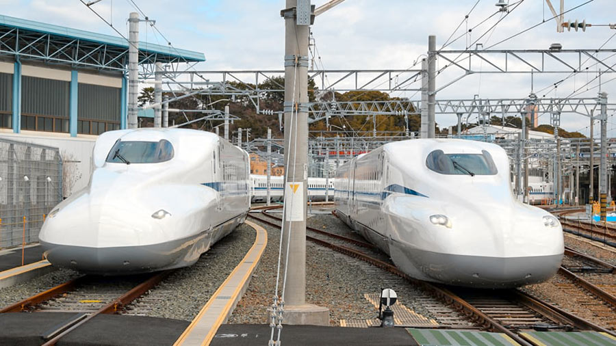 The general manager of Central Japan Railway Company, the Japanese firm designing the would-be Houston-Dallas bullet train, tells WFAA’s Jason Whitely it’ll be a spin-off of the company’s recently-revealed N700S model, 2 prototypes of which appear above. That new design — test runs of which began in July — is a half-size version of the N700 stock the company currently operates along Japanese rail lines: 8 cars instead of 16. They’re planned to start
 hurdling hurtling down the country’s Shinkansen rail network at 177 miles-per-hour in 2020, by which time Texas Central — our state’s own high-speed rail hopeful — expects to have broken ground already on its 240-mile right-of-way. It says its version of the trains — to be named the N700I (“I” for “international”) will start off running at 186 miles-per-hour but could later accelerate up to 205, “subject to regulatory approval and market demands.” [WFAA; previously on Swamplot] Photo of 2 N700S Shinkansen prototype trains: Texas Central


Both Red- and Purple-Line connections to Hobby Airport made METRO’s latest shortlist of proposed projects around town. They’re indicated above by the blue segment which runs east from the Red Line’s current terminus at Fannin South and past a proposed spur that’d reach up to the Purple Line’s last stop at Palm Center Transit Center. Together with all the proposed bus route upgrades colored orange, they’d cost the agency about $3 billion to build.
That price tag is on the high end of what METRO expects to have in its budget for projects over the next 2 decades: somewhere between $1 billion and $2.8 billion, according to the Chronicle‘s Dug Begley. Planning for the worst case, the agency also released a plan B — which eschews all airport rail connections in the name of frugality:
Transit Wishlist

NEW BIRD-SHAPED BOATS PUT FORMER WOODLANDS CRUISER PASSENGERS IN THE DRIVER’S SEAT  A flock of 10 swan-shaped boats has now picked up where The Woodlands’ 6 Waterway Cruisers left off when they were destroyed by Harvey last year — reports the Villager’s Marialuisa Rincon — rendering the township’s shipping channels unnavigable by public transit. (One Cruiser survived, but town officials decommissioned it anyway when they terminated their contract with the boat service’s operator in February.) Now, their “long-necked replacements” have former passengers taking water travel into their own hands through the use of a rudder — and their feet, by pedaling — to get where they want to go. Lake Robbins and anything past the Anadarko Bridge along the north edge of Lake Woodlands are off-limits — but aside from that, it’s pretty much free swim in the rest of the lake, as well as the upper and lower waterways. After hours, all bird boats rest in the Riva Row Boat House opposite The Pavilion. [Houston Chronicle; more info] Photo: The Woodlands Township

BOBCAT TEDDY’S NEW BCYCLE STATION IS READY TO ROLL  The recent docking of a new BCycle station outside the former Jimmy’s turned Bobcat Teddy’s Ice House on the corner of White Oak Dr. and Threlkeld St. brings the total number of bike hubs in the system to around 60. Its installation was supported in part by a fundraiser held at the bar last month during which representatives from Texas Gold Sprint’em — an operator that hosts stationary bike races complete with emcees and accompanying AV equipment — were on hand to organize competition. Now that road-ready vehicles are on-site at the venue, they fill in a gap along White Oak Dr., where no other BCycle station currently exists. [Houston City Planning Department; previously on Swamplot] Photo: Houston City Planning Department

WHAT TXDOT’S TINY 2-YEAR PUBLIC TRANSIT ALLOWANCE ADDS UP TO  Transit-focused fact-finder Allyn West pulls out this nugget from the Texas Tribune’s report on regional transit development: “While the Texas Department of Transportation has a budget of more than $26 billion for the 2018 and 2019 fiscal years, less than 1 percent of that is earmarked for public transit.” That puts the burden squarely on county and local agencies — including metropolitan planning groups like the Houston-Galveston Area Council — to dig up funding for non-car-catering projects. [Texas Tribune via Allyn West] Photo of Preston St. METRO stop: telwink via Swamplot Flickr Pool


The first stretch of concrete is down along a northern portion of the dedicated bus route that’s set to run up the middle of Post Oak Blvd. between Westpark Dr. and the West Loop. The photo at top looks north to show the freshly-paved southbound lane lying in the middle of the existing roadway, where it’s now making a stop at San Felipe St.
Its next drop-off point: Ambassador Wy., as indicated in the map below:
Trailblazing


The 2 new METRO bus lanes — linking a proposed Bellaire transit center to the new middle-of-the-road path up Post Oak Blvd. — won’t run over the actual building at Chick-fil-A’s Richmond Ave location, but they will cut through the property. Last month, the fast-food company agreed to vacate its spot at 5005 Richmond after the State of Texas initiated an eminent domain proceeding against it — and the location subsequently closed. (The 4 strip tenants in Weingarten Realty’s surrounding Richmond Square Shopping Center — BestBuy, Mattress1One, Cost Plus World Market, and Luggage & Leather — are also targeted in the proceeding.)
Adding the new transit route (shown in the map below as a vertical orange line partly covered-over with yellowish-gray) is part of a whole tangle of changes TxDOT has planned for the 610-59 interchange:
Eminent Domain

METRO NOW TESTING OUT SELF-DRIVING BUSES FOR HOUSTON  Preliminary tests of the new autonomous buses METRO is studying for potential use in Houston have gone well so far, agency board member Sanhjay Ramabhadran said at a luncheon in Cy-Fair on Tuesday — “although,” he added, “they tend to overheat in the Texas weather.” The next test phase, METRO spokesperson Jerome Gray tells abc13, “will be on the campus of Texas Southern University with a small bus at slow speeds.” If it goes well, a prototype could then graduate to real traffic. Last January, the U.S. Department of Transportation named Houston one of 10 official proving grounds for driverless buses “in part for its miles of HOV lanes that could easily work as testing lanes.” [abc13] Photo: METRO

TEXAS CENTRAL HAS NEARLY A THIRD OF PROPERTIES NEEDED FOR BULLET TRAIN, IT SAYS  Would-be bullet train builder Texas Central tells the Chronicle’s Dug Begley it has secured nearly a third of the properties it needs for the planned rail line between Houston and Dallas. But Begley notes that company “officials have not specified where those tracts are located or how much of the 8,000 [required] acres they include.” The train developer is currently negotiating with landowners to buy up parcels along the route. As for plan B: “Though state lawmakers essentially have barred the company from using state authorities to condemn property, Texas Central maintains it has some options via federal authorities as a railroad, under Texas law.” [Houston Chronicle ($); previously on Swamplot] Photo of Texas Central public hearing at Woodard Elementary School, Cypress: Marc Longoria via Swamplot Flickr Pool

COMMENT OF THE DAY: TEXAS CENTRAL’S PARKING GARAGE ISN’T JUST A SIDE GIG  “Site plans of both stations (Houston and Dallas) make it clear that the revenue model for this project isn’t selling train tickets — it’s selling parking. This site is ideal for that purpose: there’s no where nearby (walking distance) to compete for parking revenue, and it has a much cheaper land cost than Downtown. If you’re going to make the station 80 percent parking garage, why bother spending the extra money running it all the way to Downtown?” [Angostura, commenting on What Texas Central’s Proposed Houston Bullet Train Station Looks Like in Place of the Northwest Mall] Conceptual rendering of Houston bullet train station from W. 18th St.: Texas Central


The video at top put out by Texas Central pans around the what’s now the Northwest Mall and its parking lot to show a new double-arched bullet train station and parking garage replacing them in the crotch where W. 18th St. and Hempstead Rd. meet the West Loop. Texas Central chose the 45-acre site over 2 others it was considering just south of the mall for the Houston terminus of the planned Houston—Dallas rail line. The terminal building — coded orange in the site plan above — sits between Hempstead and a new road that’s proposed just north of it. The parking garage would be located inside the gray zone indicated between W. 18th and the new street.
Elevated train tracks enter the station after crossing over a new extended segment of Post Oak Rd. Looking southeast from W. 18th St., one of Texas Central’s conceptual renderings of the site shows the tracks tracks heading into the terminal, next to the parking garage:
Park and Ride
