05/21/18 4:30pm

Remember that North Canal that showed up in Plan Downtown’s maps and drawing last year and included a island in Buffalo Bayou? Well, TxDOT’s latest schematics for its planned I-45 reroute include a bypass and island as well — but in an entirely different location. The highway agency’s map above — with west facing up — indicates a new waterway draining into Buffalo Bayou right underneath the section of I-45 it plans to build in place of a portion of the Houston Housing Authority’s Clayton Homes neighborhood. How the canal gets there is obscured, but a straight course northwest appears to shoot the gap between 2 planned detention ponds and cross under the existing section of 59 (shaded gray), before linking up with the bayou again east of Elysian St. Marooned on TxDOT’s version of the make-believe, bayou-banked island the canal would create: a few of the houses in Clayton Homes.

As TxDOT’s caption makes clear, it’d be up to someone else to actually build the waterway. Doing so wouldn’t preclude the previously proposed North Canal from being dug further upstream. Plan Downtown’s less technical map at top shows that waterway beginning at White Oak Bayou and emptying into a bend of Buffalo Bayou just west of Elysian. In doing so, its course creates an exclusive new landmass home to the Harris County jail.

Road map: TxDOT. Downtown map: Plan Downtown

Offshored
05/04/18 4:15pm

The 2 new METRO bus lanes — linking a proposed Bellaire transit center to the new middle-of-the-road path up Post Oak Blvd. — won’t run over the actual building at Chick-fil-A’s Richmond Ave location, but they will cut through the property. Last month, the fast-food company agreed to vacate its spot at 5005 Richmond after the State of Texas initiated an eminent domain proceeding against it — and the location subsequently closed. (The 4 strip tenants in Weingarten Realty’s surrounding Richmond Square Shopping CenterBestBuy, Mattress1One, Cost Plus World Market, and Luggage & Leather — are also targeted in the proceeding.)

Adding the new transit route (shown in the map below as a vertical orange line partly covered-over with yellowish-gray) is part of a whole tangle of changes TxDOT has planned for the 610-59 interchange:

CONTINUE READING THIS STORY

Eminent Domain
04/23/18 1:45pm

The Southmore bridge — known to get real cozy with floodwaters as they course down 288 — made its last stand this weekend as crews cleared the way for a new, presumably higher roadway that’ll be built in its place. Lanes of 288 — pictured above from the northbound side — shut down to accommodate the demolition. The bridge itself had been closed since earlier this month closed on Friday. Now, thru-traffic is being detoured to the Blodgett and Binz St. bridges across the highway via its north- and southbound feeder roads. The estimated opening date for the new structure: mid-to-late next year.

Photos: Swamplox inbox (from Southmore); Drive288 (from 288)

High-Speed Demolition
03/08/18 11:00am

Make no mistake about the signage now up along Hwy. 6 across Schiller Dr. from the Aldi near Westpark: the travel stop it’s announcing is Nebraska-born Bucky’s — not the Texan Buc-ee’s. Construction vehicles are now pushing dirt around west of the Highway 6 RV Resort where the new complex plans to go.

Last year, Buc-ee’s filed a lawsuit against Bucky’s to stop the transplant from moving ahead with plans to build at least 6 new Houston-area locations. One Bucky’s is now open on NASA Pkwy. in Nassau Bay, but besides that, all other operational Bucky’ses are currently out of state: in Omaha, St. Louis, and the Chicago area.

Across the street, Twistee Treat Westpark is flanked by Golden Corral and a Take 5 Oil Change, and backed up by a Palace Inn:

CONTINUE READING THIS STORY

The Buc Stops Here
02/09/18 4:00pm

COMMENT OF THE DAY: IDENTIFYING THE WILDLIFE ON THE VALENTINE CORNER LAW OFFICE IN SEABROOK “So those are dolphins along the sidewalk, made many years ago by Mr. Miller across the street. And there were sharks on the side of the building up high. I took them down a few years ago to have the sharks polished, and the guy I hired disappeared with my 2 sharks.” [Michael Valentine, commenting on TxDOT Wins Custody of Head-Turning Tiny Law Office in Seabrook Ahead of Planned Hwy. 146 Widening] Photo of Valentine Law Office, 1210 Bayport Blvd.: BFS Man [license]

02/07/18 4:30pm

The 660-sq.-ft. law office marooned on a traffic island in Seabrook for 86 years might finally get ousted from its spot in local what-is-that-thing lore when TxDOT’s planned road widening project gets underway along a 3-mile stretch of Hwy. 146. Attorney Michael Valentine bought the building on the corner of Bayport Blvd. and 2nd St. in 1989 and did it up with the leafy haircut and  shark dolphin-themed metal edging. (Bayport Blvd. is the segment of 146 that runs through Seabrook — shown to the left of building in the photo at top.) In its past lives, the 2-story wedge at 1210 Bayport had been at various points an ice house and a bait shop.

Documents filed with Harris County Clerk show that TxDOT agreed to snatch the building from Valentine for a sum of $114,356 last October after filing an eminent domain proceeding against the entity he uses to administer the property. At least 9 other businesses along Bayport, including Ryan’s Cleaners, Tookie’s Burgers, and Laredo’s Tex-Mex Cafe have already closed or relocated ahead of the roadwork that plans to turn 146 between Red Bluff Rd. and Clear Creek — currently 4 lanes — into 12.

CONTINUE READING THIS STORY

Eminent Domain
04/21/17 12:30pm

WHERE HIGHWAY 87 CRUMBLED BEFORE THE TIDE mcfaddin-erosion
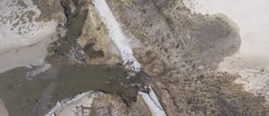
The part of Texas “[where] storms are what you talk about” is the subject of John Nova Lomax’s dispatch this week in Texas Monthly — more specifically, the 16-mile stretch of coast where the state gave up on rebuilding SH 87 after the last of a series of hurricane washouts in the 1980s. Amid nude beach signage, dolphin carcasses, and the rusting remains of pipelines and 4-wheelers, Lomax meditates on the idea that the battered stretch of coast, where Texas’s beaches and barrier islands begin dissolve away into a Louisiana-style tangle of eroding wetlands, “once functioned as a seawall: there was a natural ridgeline made of shells and sand that was used as a trail by Native Americans, then Spaniards, then Texans. Then the ridge was bulldozed and repurposed to grade Highway 87, the road that no longer exists — and the one bulwark against the sea was gone.” [Texas Monthly] Photo of eroding highway in McFaddin National Wildlife Refuge: US Fish and Wildlife Service

04/21/16 4:45pm

Potential Flood Map, Bear Creek, Houston, 77084

The Army Corps of Engineers will begin releasing water from the Addicks and Barker dams later this evening; nonetheless, water levels in the reservoirs are still expected to rise high enough to cause street flooding in the Bear Creek subdivision north of Clay Rd. The Corps also notes that nearby residential areas should anticipate that wildlife inhabiting approximately 26,000 acres of forested land in the 2 reservoirs may flee the rising water and enter nearby neighborhoods. That wildlife may include the feral pigs previously targeted by Harris County Precinct 3’s trapping-and-foodbanking program; sightings of animals such as deer, coyotes, and bobcats have also been reported in the reservoirs.

Harris County Flood Control District has published a list of streets that could be impassible for days or weeks due to flooding, as well as a few maps (one of which is shown above). Here’s the other map below, highlighting in pink the streets south of Addicks Satsuma Rd. and Langham Creek expected to get water when the level in Addicks reaches 103 feet:

CONTINUE READING THIS STORY

Creeping Into the Neighborhood
04/21/16 10:30am

road-closures-4-21

Replacement work on the Yale St. bridge over White Oak Bayou now won’t start until the 25th, according to an update from TxDOT. The original planned construction start drifted past in the middle of Monday’s deluge; no changes have been mentioned yet for expected 2018 reopening date.

Meanwhile, TxDOT’s Yoakum office says it’s keeping an eye on US 59 in Wharton County to the southwest of town, though that highway is not closed at the moment according to the agency’s interactive mapping system (pictured above). The map shows areas of road closures, flooding, and construction, with written descriptions for each site clarifying which lanes are affected, by what, and how badly. Zooming in further gives a clearer picture of the extent of some of the closures — below is a view of west Houston, showing the stretch of Hwy. 6 near the Addicks reservoir that could be closed for the next 4 to 6 weeks: 

CONTINUE READING THIS STORY

What’s Under Water