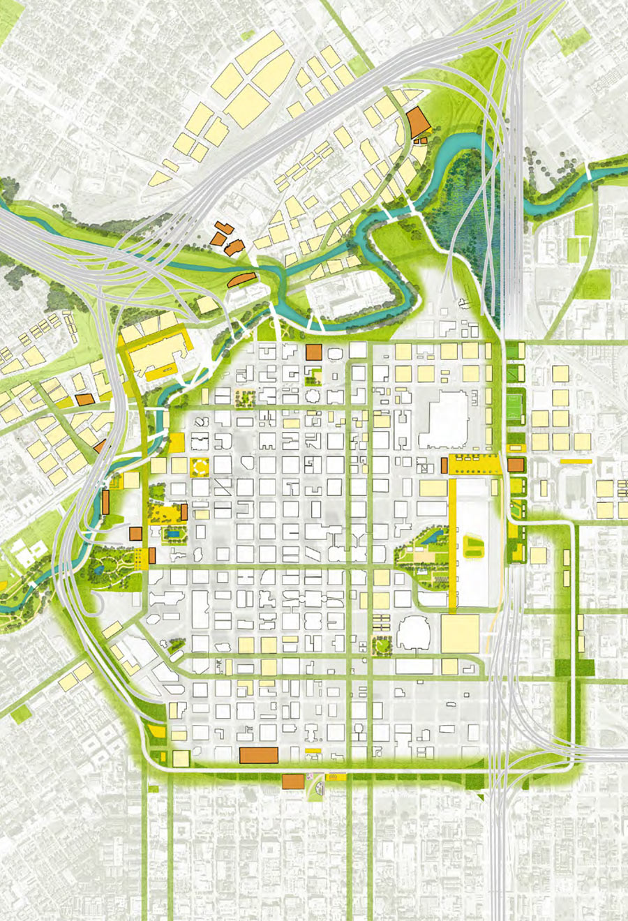
More new features are imagined for the center of Houston than just the new Green Loop highlighted in the just-released Plan Downtown proposal. There’s also a mysterious new Downtown island. Where did it come from?
It’s the result of digging the long-whispered North Canal Channel Bypass, a re-linking of White Oak and Buffalo Bayous north of Downtown. Existing bends and narrow banks along the 2 bayous just east of Main St. restrict the flow of stormwater during flooding events. According to reports, engineering studies have estimated that cutting a straighter diversion channel to bypass the oxbow could reduce flooding Downtown by 3.5 ft.
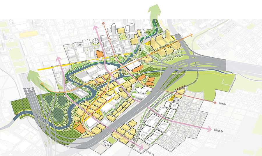
But digging a new canal while maintaining the existing path of the bayou would create an island out of the area just north of Commerce St. An imagined map of the area in Plan Downtown’s report (rotated so North is aimed down and to the right) shows what car and pedestrian bridges might link it to the mainland:
***

Drivers looking to travel north across Buffalo Bayou and out of Downtown could do so via the same 2 bridges they have access to now: on Fannin St. and San Jacinto. After crossing the bayou, those 2 roads would merge into an extended San Jacinto St. in the Plan Downtown plan, forming the only car route across the North Canal — before connecting to Fulton St. to the north.
METRO’s bus facility east of San Jacinto would have to be relocated;Â 2 pedestrian paths (one along the water shown in yellow, the other shown in orange in the map above) would cross the canal in its place. Both appear also to be part of the network of trails comprising the proposed Green Loop:

- Plan Downtown Final Report (PDF) [Plan Downtown]
- North Canal Bypass Channel [HCFCD]
- Cover: Flood relief project holds promise [Houston Chronicle]
- Master Plan for Buffalo Bayou and Beyond (PDF) [Plan Houston]
- Previously on Swamplot:Â A Roundabout First Look at the Green Loop, the Newest Idea for a Houston Ring Road Around Downtown
Images: Plan Downtown


This plan shows we’ve got some highly creative minds working to make this city an outstanding place to live and work. Streets designed for driverless transit and cars, San Jacinto connecting to Fulton, Commerce becoming a produce row…plus more mixing of rec and flood control…all good.
Considering the real possibilities of an economic crash, social and political revolution in this country and worldwide before 2036, I’d be happy to see half of it completed by then.
Dream big, and settle for a swamp lot.
So the only thing on the island would be the jails?
Didn’t Downtown Houston get enough water with Harvey?
Onward into the future !!
Can we name it Allencatraz?
This reminds me of a big buffalo bayou redevelopment plan presentation that was around in the early 2000s. The idea was to make the bayou like the Seine and have islands with entertainment districts. What we actually ended up with pales in comparison to the original plans, but is still very nice.
So, planners of this Green loop thing should have kept this plan under wraps and submitted a completely over the top plan to make the Green Loop into the worlds largest botanical garden, whitewater river exhibition course, exotic bird aviary, 30,000 seat amphitheater, border collie agility course, and craft cidery. Then, through the usual process in Houston of “no, that’s too difficult/expensive, but maybe we can do something far less ambitious” will yield the current plan for the Green Loop. You have to think big to get something that doesn’t suck in Houston.
funny OldSchool
It’s only the Couny Jail… what could possibly go wrong?
I’m pretty sure the idea for this island has been around for even longer than the 2000 plan. I recall seeing it in some redevelopment plans for University of Houston-Downtown from back in the early 80’s.
You might be able to talk someone at the UHD Library into showing you those plans if you’re curious.
That plan in the late 90’s – early 00’s had a rowing area so that the Rice Crew team would not have to travel to Clear Lake. The problem with all of these is that the Bayou STINKS. There is no getting around that. The “treated” sewage of 2-3 million folks flows into that every day. And it is untreated during flooding events.
So good by to the old UHD steam plant? I thought that was a historic building? Not that it means anything in Houston.
@ Old Codger
If Buffalo Bayou stunk so much, then no one would have built a bunch of expensive homes all along it (west of downtown). Most of the Houston area’s waste water effluent flows into the Bayou east of downtown anyways. The Clinton/69th plant (the largest in the city) is just east of downtown, and the Sims and Braes plants don’t enter until well past downtown. With that said, I don’t think the treatment plants are the big contributors to the overall unpleasantness of the buffalo bayou water (flood events not withstanding). Most of the effluent (when the plants are properly operating) is nearly clear and usually only has an “earthy” odor to it if any at all. I think the big issue with the bayou’s water quality is the regular runoff and trash that flows into it and eventually lines the shores of it all along downtown.
The island concept isn’t new. You can see it in the 2002 Buffalo Bayou Master plan.
I’ve never known Buffalo Bayou to stink, although I have to admit that its been years since I hiked along or thru it. I still live close by, though. OTOH, lack of stink does not necessarily mean that contact with its water is safe. I suspect that it has high levels of E. Coli and other unpleasant stuff. Despite that (if true), it does support wildlife.
I support the idea of the bayou bypass channel, even tho’ I am disappointed that the resulting “island” will just be our own little version of Alcatraz.
As commented below, the North Canal was a major recommendation from Buffalo Bayou Partnership’s 2002 Master Plan, Buffalo Bayou and Beyond. Studies have shown that it could significantly reduce flooding in downtown as well as along upper White Oak Bayou. Our organization is promoting the project post Harvey. The Canal also was a visionary idea first recommended by the late architect Charles Tapley in the 1970s.
Here’s the 2002 Buffalo Bayou Master Plan if anyone is interested, http://planhouston.org/sites/default/files/plans/MasterPlanforBuffaloBayouandBeyondJW.pdf. Lots of great ideas still on here.
we live near the bayou/allen parkway near midtown and use/go there 5-7 times a week (run, bike, dog walks, hike, etc.). can access many parts of city via biking allen parkway, even magnolia. living in mdtown, saw how it worked to keep midtown dry during harvey. always used bayou trails for biking for many years. one of nicest aspects of the city right now. we, who get of the house and it use it daily. in some ways, main complaint is that people like some on here have not begun to use it.
I hope Bre is referring to Magnolia Park in the East End. That’s certainly reachable by following the bayou. Magnolia, however, is out past Tomball.
So, an island of jails. Fancy!
Re stink: The jail stinks more than the bayou.