CITY WISHLIST FOR DAIRY ASHFORD: WIDER ROADWAY, HIGHER BAYOU BRIDGE  On city council’s agenda for tomorrow: a vote of support for widening Dairy Ashford Rd. from 2 to 3 lanes on each side between Westheimer and I-10. As part of the roadwork, the existing bridge across Buffalo Bayou would be rebuilt — potentially above 500-year floodplain level, though the city hasn’t decided yet. New, wider sidewalks are on the table, too. With the council’s blessing, Houston’s public works department would next submit an application for the project to the Houston Galveston Area Council, which could choose to help pay for it with state and federal money. [Houston City Council Agenda] Map: Houston City Council
Sign up for the Newsletter
Tag: Bridges


Here’s one of Houston’s latest walkable undertakings: converting the former railroad bridge beneath 59 to a pedestrian bridge that’ll link the trail along the bayou’s north bank to planned pedestrian segments south of waterway. It’s now overshadowed by the tangle of overpasses directly above it, but might not be once TxDOT starts straightening out 59 by nudging it east (and pairing it with a parallel segment of I-45) as part of its grand plan for north Houston highway improvement.
No southern trail segments are in place yet to greet the bridge upon its landfall just east of Downtown, but they will be soon: TxDOT’s already broken ground on a trail that’ll skirt the bayou as it crosses through the Houston Housing Authority’s Clayton Homes Neighborhood east of 59.
It’ll link up with the southern trail segment that does exist and runs east toward Lockwood Dr., as indicated by the gray line in the map below:
Bayou Trailwork

COMMENT OF THE DAY: I-10 LOW-BRIDGE ALERT SYSTEM ISN’T EYE-CATCHING TO PASSING TRUCKERS  “The sign mentioned in the posting is a joke — it’s small, off to the side, partially obscured, and it is not readily apparent what it’s referring to. Worse than that, it is 2 miles ahead of the 610 interchange, and 7 miles ahead of the Houston Ave. overpass. It is nowhere close to a sufficient or effective system, and along with the new low clearance signs inside the Loop, has every appearance of a band-aid solution to something that needs a more comprehensive approach.” [TMR, commenting on How TxDOT Tries To Stop Trucks from Clipping the Houston Ave. Bridge] Photo of I-10 near Houston Ave. bridge: Marc Longoria via Swamplot Flickr Pool


The latest 18-wheeler to drive into the Houston Ave. bridge didn’t make enough of an impact to force repairs yesterday, although it did stall I-10 traffic all the way to T.C. Jester while TxDOT closed 2 lanes to clear the debris (including the truckload pictured above pinning a sedan) and inspect the overpass to ensure its integrity. (The last round of bridge maintenance in March — to repair a strike in December — couldn’t have come at a better time: “Just as crews were putting barriers in place,” for an overnight closure to fix the damaged structure, another truck drove into it — reported Houston Public Media’s Gail Delaughter.)
Over the last 4 years, the 14-ft.-3-in.-high bridge has been hit 22 times — reports Click2Houston; historically, it’s struck “more than any other bridge in the Houston area,” says a TxDOT spokesperson. Not a great track record — until you factor in how many trucks aren’t hitting it as a result of TxDOT’s high-tech warning system. In 2015, the agency installed infrared sensors at Mercury Dr. and Wirt Road that detect oversized vehicles and — if spotted — flash a warning message to get off the road on an electronic billboard. Between January and June 2 of this year alone, the sensors transmitted 13,477 warnings.
- TxDOT using ‘size detectors’ to limit bridge strikes [KHOU]
- Grappling with a pair of Houston bridges that keep getting hit [Click2Houston]
- Bridge Due For Repairs Is Hit Again By A Truck, TxDOT Moves Ahead With I-10 Closure [Houston Public Media]
Photos: Emily Black
Chronic Drive-By Zone


Construction on the new pedestrian bridge going up across Brays Bayou in Mason Park is heading into its 14th month. When it’s done, the 16-ft.-wide, 485-ft.-long structure will provide a link between the north section of the park off S. 7th St., and its southern portion — currently the only part of the 104-acre green space with access to the Brays Bayou Greenway Trail.
The bridge’s landing point on the south side will overshoot the trail by a bit though, as shown in the rendering below:
Bayou Biking Link


The basic structure of a new bridge crossing from one side of the Conrad Sauer Detention Basin to the other in the northward expansion of Memorial City is now in place, this recent photo (above) from reader Marc Longoria shows. The bridge will be part of Mathewson Ln., which developer and property owner MetroNational is extending from Conrad Sauer Dr. eastward over the detention basin and connecting to Gessner Dr., as shown in this recent construction photo:
Memorial City Marches North

ELYSIAN VIADUCT WORK UNEARTHS HISTORIC HOUSTON HERITAGE TRASH PILE 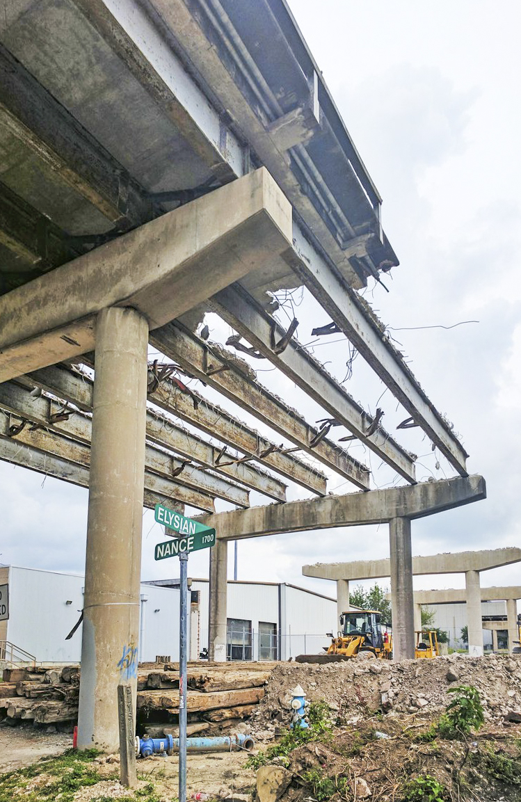 The real value of the long-buried dump uncovered by the ongoing replacement of the Elysian St. bridge over I-10 and Buffalo Bayou, write Doug Boyd and Jason Barrett this week in the Chronicle, is in the opportunity it provides “to document the often-unwritten parts of our industrial heritage.” The dump, apparently built up over the early half of the 1900s in a former gully, serves as a springboard for the authors to talk trash — Houston, they write, was one of the first cities to adopt widespread municipal garbage incineration, and lagged decades behind as most cities chose to stop doing it out of concern for public health. Spots like the one under Elysian St., they add, help fill in the gaps of knowledge of what happened to all the other trash that didn’t end up in a city incinerator or landfill — and who tended to live nearby. [Houston Chronicle; previously on Swamplot]  Photos: Adam J Williams

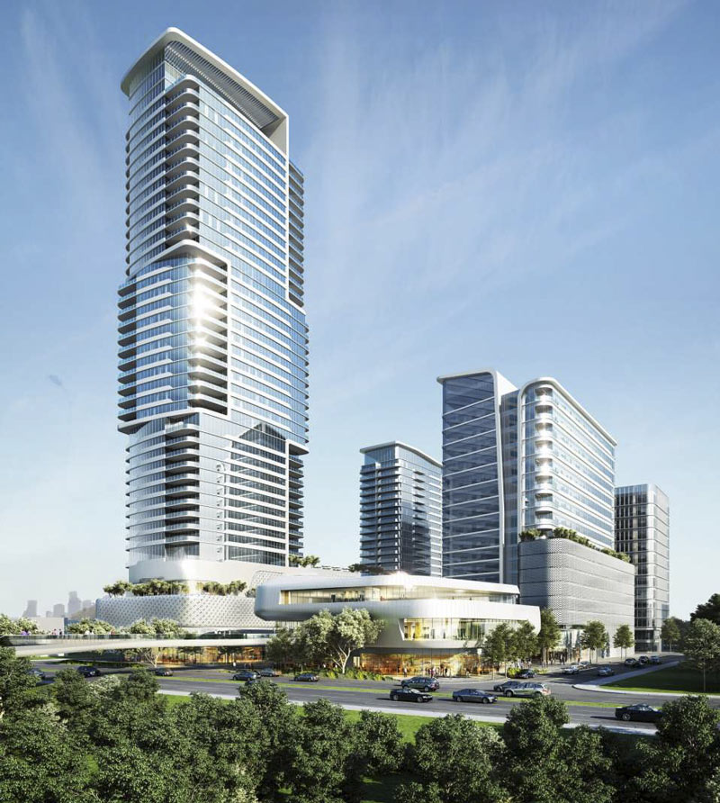
New renderings of the hotel-office-condo-retail hodgepodge in the works on the northern segment of the former city park and waste incinerator site at Allen Pkwy. and Gillette St.  were released into the digital wild by DC Partners this week. The buildings appear smoother and sleeker overall than some of the possible early depictions turned up last August (like the Downtown-facing view shown second above for comparison), though some elements of the cluster also appear a bit shorter and stouter. The main tower along Allen Pkwy. has been given a twist in the middle, with a floorcount appearing to number somewhere in the 40-plus range; the lowrise retail complex next door is shown with a bridge over the parkway leading directly into Buffalo Bayou Park.
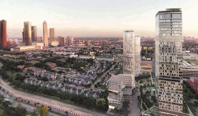
Perennial rendering sleuth Urbannizer also dug up a different view of the new scene over on HAIF, showing how the whole bundle would fit in amid the Federal Reserve complex, the park, and the section of Fourth Ward surrounding what’s left of the Freedman’s Town Historical District:
Like a Bridge Over Allen Pkwy.

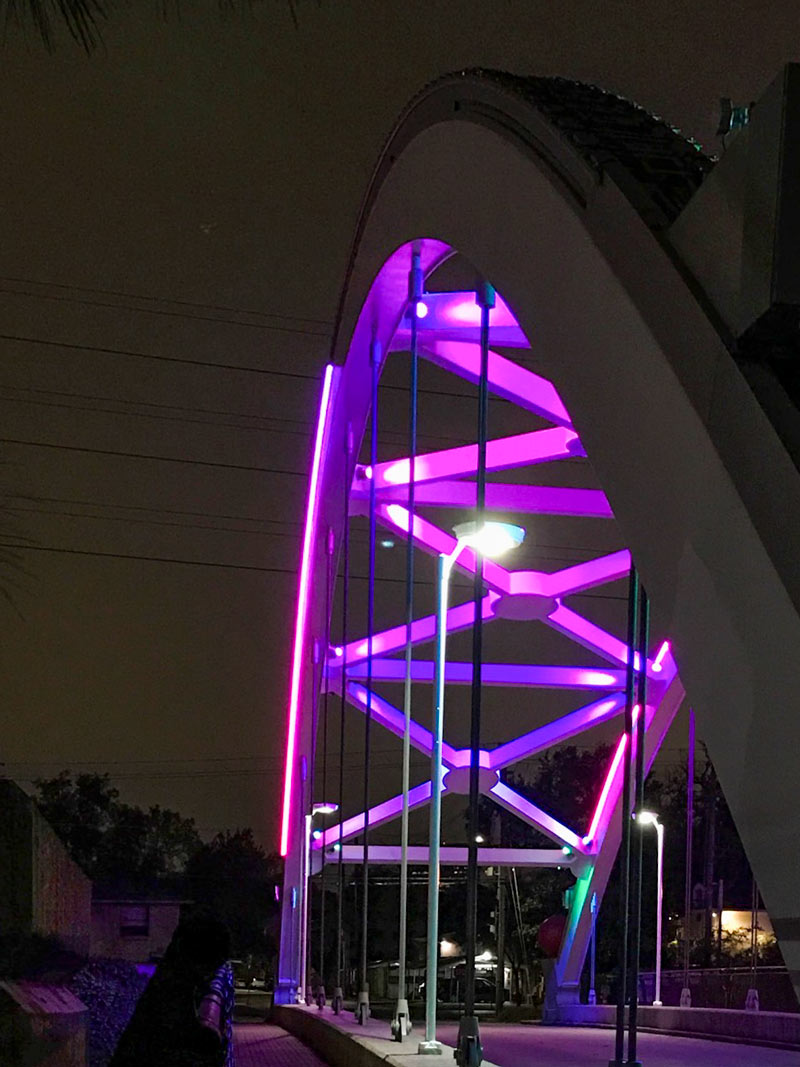
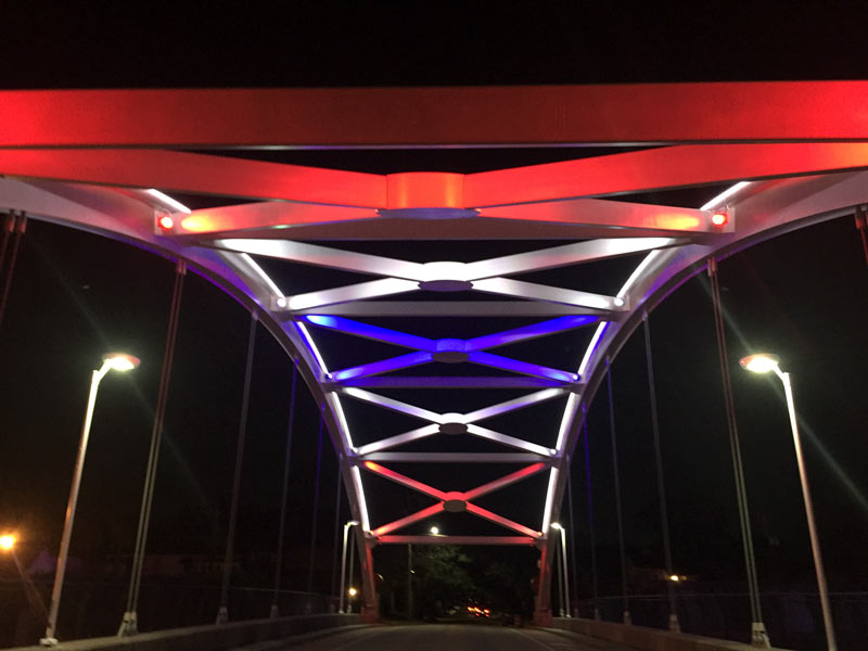 Just because the crossings over US-59 were broadcasting football team colors in time for the Super Bowl last month doesn’t mean they were totally finished, Sarah Gandy from Gandy² Lighting Design tells Swamplot this morning. A number of readers have written in since the game to note bits and pieces of the new lighting going dark (as seen in the top shot), blinking, or appearing to be stuck on mismatched colors on occasion; Gandy says that per pre-game plans, there is still some hardware being installed and tuning being done, and that the contractors on the project aren’t scheduled to be totally wrapped up for a few more months.
The forecast for tonight’s display — minus at least 1 bridge which’ll be getting worked on for the evening — is St. Patrick’s Day green; the bridges also spent some of the leadup to Mardi Gras last month enthusiastically flashing passing drivers with traditional bead colors:
Minor Turnoffs

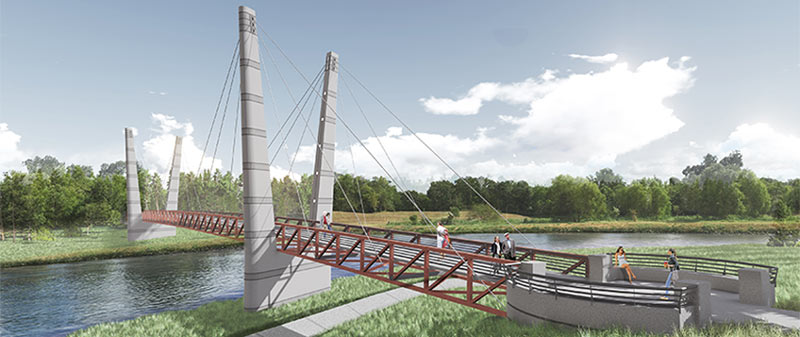
A double-V’d walkin’ and bikin’ bridge like the one shown above will be spanning Brays Bayou before too long, the Houston Parks Board says, linking together the sections of Mason Park separated by the waterway. The agency is planning a short mid-morning party for the planned structure’s construction kickoff next Tuesday, on the southern side of the park (mostly located east of the 75th St. crossing). The whole complex is just downstream of the Gus Wortham Golf Course, for which renovations finally teed off a few weeks ago (trailing much ado a few years back that culminated in the land not getting turned into a botanical garden).
The board says the other, decidedly less suspenseful pedestrian bridge announced earlier this year should be done in the fall as well; that one will will run across Brays alongside the Martin Luther King Blvd. car bridge at the downstream edge of of MacGregor Park, and look kinda like this:
Double Crossing Brays

The newly LED-equipped crossings over US-59 between Shepherd Dr. and Midtown should be getting officially flipped on around 8 pm tomorrow, after a few weeks of on-and-off testing. The 2 Gandys of Gandy² Lighting Design tell Swamplot that the lights will likely run from sunset to sunrise; the tentative plan in the leadup to the Super Bowl is for the bridges to show off the competitors’ team colors. The Patriots’ red-white-and-blue are demoed above, but here are some shots of what else the new fixtures can do, now that all the tuning up is largely finished:
Getting Turned On

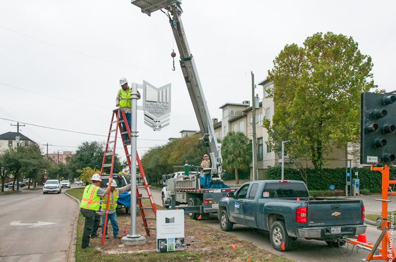
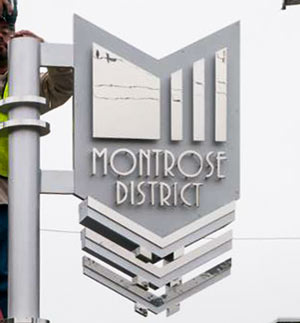 The Montrose Management District reports that the first of its shiny new neighborhood marker signs went up over the weekend at Montrose Blvd. and Dallas St., despite the recent movement in the ongoing lawsuit between the organization and the group of property owners petitioning to dissolve it. The case, which was filed in 2012, is still open, though the judge recently filed a handful of findings and judgment documents stating that not all of the signatures that went into forming the district were valid, and that the agency must pay back the $6.5 million it’s collected since then. The district has said it has no plans to do that any time soon, and intends to keep on keepin’ on until any appeals wrap up, which could be years from now.
The signage is part of the sundry prettification projects the district has planned for the neighborhood, which include redoing the colored lighting on the bridges over US 59 — thanks to a funding assist from the city, TxDOT, and the Houston Galveston Area Council:
Sightings on W. Dallas

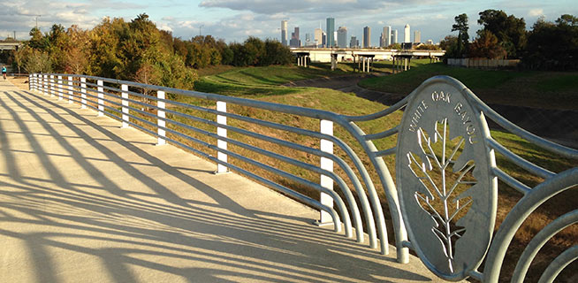
The section of bayou-hugging greenway trail running between Durham St. and Stude Park is getting the official OK tomorrow morning from Harris County Flood Control District and the Houston Parks Board. The photo above is of the pedestrian bridge across White Oak near Durham St. that previously supplanted the area’s “Bridge of Death” route; the segment opening tomorrow runs from that same bridge east along the bayou to the Studemont St. non-pedestrian bridge. The organizers are hoping would-be trail fans will use some means other than car to get to the ceremony location (off Studemont just north of I-10); if you have to drive, however, the invitation says you might be able to get a parking space across the freeway north of  Target.
Further east along the White Oak trail, here’s an updated view of how that link into Near Northside by the Leonel Castillo Community Center is coming along (taken in mid-November, once again from the same spot as that glitzed-up flood photo that made an appearance in Air New Zealand’s recent in-flight feature on Texas):
Greenways Growth Spurts

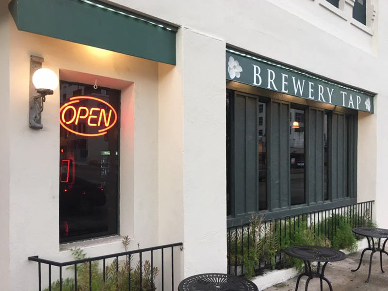
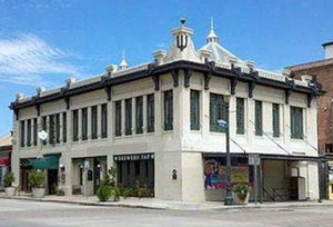 Ghost-story hub and beer bar Brewery Tap reopened this weekend, after about nearly 11 months of remodeling in the wake of a January ownership swap. The bar is located in the building at 717 Franklin St., preivously part of Houston Ice & Brewing Co.’s Magnolia Brewery complex on the edge of Buffalo Bayou. Down the slope beneath the Franklin St. bridge is the mid-1800’s crypt previously occupied by the remains of 3 members of the Donnellan family; the early Houston settler and his wife and son were moved west to Glenwood Cemetery around 1903, after which the crypt was incorporated into the structure of the Franklin St. bridge:
Digging Up Downtown History

COMMENT OF THE DAY: TAKE IN THOSE SCENIC INDUSTRIAL HOUSTON SIGHTS JUST LIKE A LOCAL! 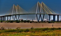 “I’ve got a better business plan when it comes to views from the new Beltway 8 bridge: Since the new one is going to be a suspension bridge much like the Fred Hartman bridge, climbing it like the  [Sydney] Harbor bridge will be out of the question. So here’s what I’ll do: For a fee, I’ll place a hole of strategic size in your back left tire. I’ll calculate the proper size in accordance to your vehicle make, number of passengers, and weight. You then take a leisurely drive up the bridge — and by the time you reach the apex of the bridge you will be forced to pull over as you can no longer drive on your flat back left tire. Then and only then will you have the glorious view of the Ship Channel that you crave as you wait for AAA. Remember, my fee will be very modest and you’ll be experiencing the REAL Houston bridge view experience that only we locals have been blessed with for years.” [DNAGuy, commenting on Houston Home Sales Bounce Back; Calling Brooke Smith as the Next Heights] Photo of Fred Hartman Bridge: Jackson Myers via Swamplot Flickr Pool
