COMMENT OF THE DAY: CURRENT HOUSTON AIR SMELL RATINGS, MINUS THE COFFEE PERFUME  “It seems like it’s getting worse. 4 out of 7 mornings when it used to be maybe 2 out of 7. I wonder if it’s because the east downtown coffee plant has been shutdown, no longer masking the more harsher notes.” [Jeff, commenting on The Houston Hurricane Pollution-Sniffing NASA Flight That Never Took Off] Illustration: Lulu
Sign up for the Newsletter
Pollution

THE HOUSTON HURRICANE POLLUTION-SNIFFING NASA FLIGHT THAT NEVER TOOK OFF  A week and a half after Hurricane Harvey hit Houston, as damage to smokestacks, pipelines, and chemical storage tanks were still being assessed, flooded Superfund sites went unmonitored, and clouds of benzene and other chemicals assembled in the skies over the city, the crew of a California-based airborne NASA chemical lab offered to help figure out the state of affairs — by diverting its specially equipped DC-8 from a planned trip to Oklahoma to take measurements in Houston instead. But EPA and TCEQ officials vehemently passed on the offer. An email response from TCEQ air toxicologist Michael Honeycutt noted that “state data showed no sign for concern,” report the L.A. Times‘s Susanne Rust and Louis Sahagun. “We don’t think your data would be useful for source identification while industry continues to restart their operations,” wrote Honeycutt, who the following month was appointed to head the EPA’s Science Advisory Board by President Trump. David Gray, the EPA official in charge of the Harvey emergency response, agreed. Citing emails from Texas officials “stating unambiguously that they do not want NASA to use the DC-8 for any data acquisition,” Michael Freilich, the director of NASA’s Earth Sciences division, called off the mission. [L.A. Times] Photo of Atmospheric Tomography Mission DC-8 interior, September 2017: NASA

COMMENT OF THE DAY: THE REAL REASON WHY BUFFALO BAYOU SMELLS AND LOOKS THE WAY IT DOES  “If Buffalo Bayou stunk so much, then no one would have built a bunch of expensive homes all along it (west of downtown). Most of the Houston area’s waste water effluent flows into the Bayou east of downtown anyways. The Clinton/69th plant (the largest in the city) is just east of downtown, and the Sims and Braes plants don’t enter until well past downtown. With that said, I don’t think the treatment plants are the big contributors to the overall unpleasantness of the Buffalo Bayou water (flood events not withstanding). Most of the effluent (when the plants are properly operating) is nearly clear and usually only has an ‘earthy’ odor to it if any at all. I think the big issue with the bayou’s water quality is the regular runoff and trash that flows into it and eventually lines the shores of it all along downtown.” [nmj, commenting on The North Canal, a New Downtown Island, and Other Secret Plans for Downtown Houston’s Future] Photo: Swamplot inbox

COMMENT OF THE DAY SECOND RUNNER-UP: THINGS TO THINK ABOUT BEFORE YOU START PLANNING UNDER-FREEWAY DEVELOPMENTS  “One conclusion I’ve made about the U.S., compared to European countries, is that we don’t use space efficiently. We’ve got all these open ditches, grass patches . . . along our roadways. So this Tokyo solution appeals to me.
But while I haven’t traveled extensively, I feel that selling/renting under-highway space to retail smacks of third-world. Would Houston ever go for that?
There is so much filth that washes off roadways and would filter into/onto these shops. A friend has his bike storage cage under the apartment driveway. It’s just a drive! yet the bikes always have a greasy blackness on them. Ever park in an airport garage for more than a couple days? Your car is filthy.
Maybe it’s just me, but I wouldn’t/couldn’t eat a taco made under the Pierce Elevated.” [movocelot, commenting on Midtown Sears Closure Nets Rice 9 Acres near the Wheeler Transit Center] Illustration: Lulu
“One conclusion I’ve made about the U.S., compared to European countries, is that we don’t use space efficiently. We’ve got all these open ditches, grass patches . . . along our roadways. So this Tokyo solution appeals to me.
But while I haven’t traveled extensively, I feel that selling/renting under-highway space to retail smacks of third-world. Would Houston ever go for that?
There is so much filth that washes off roadways and would filter into/onto these shops. A friend has his bike storage cage under the apartment driveway. It’s just a drive! yet the bikes always have a greasy blackness on them. Ever park in an airport garage for more than a couple days? Your car is filthy.
Maybe it’s just me, but I wouldn’t/couldn’t eat a taco made under the Pierce Elevated.” [movocelot, commenting on Midtown Sears Closure Nets Rice 9 Acres near the Wheeler Transit Center] Illustration: Lulu

SMELLING BLIND IN THE EAST END  A possible cause of the nasty smells that caused East End residents headaches, sore and scratchy throats, and itchy eyes as Hurricane Harvey approached and inundated the area? Houston-area industrial plants in the last week released more than 2.25 million pounds of emissions above legal limits, according to an Environment Texas tally of Texas Commission on Environmental Quality data. The reason: plant shutdowns before the onset of the storm and startups after it left. “So far,” writes Emily Atkin, “TCEQ has not indicated these events have triggered health impacts. . . . TCEQ Media Relations Manager Andrea Miller told me the agency or local emergency officials would contact residents if an immediate health threat were to occur. What’s more, Miller said companies were probably reporting higher emissions that what actually occurred, ‘since underreporting can result in higher penalties.‘ It’s unclear, however, how TCEQ would check many of the companies’ reports, since the agency turned off all its air quality monitors in the Houston area before Harvey hit. Miller confirmed as much on Monday, saying devices were either turned off or removed “to protect against damage or loss of these sensitive and expensive instruments.†[The New Republic] Photo of ExxonMobil Baytown refinery: Louis Vest [license]

COMMENT OF THE DAY: MIGHT UPSET HOUSTON’S DELICATE WATERWAY ECOSYSTEM  “. . . I suppose all those cars need to come out of the bayou, but I fear that will really mess up the fishing.” [Txcon, commenting on Comment of the Day: Aside from These 2 Issues, Fishing in Brays Bayou Is Enormously Appealing]

ELYSIAN VIADUCT WORK UNEARTHS HISTORIC HOUSTON HERITAGE TRASH PILE 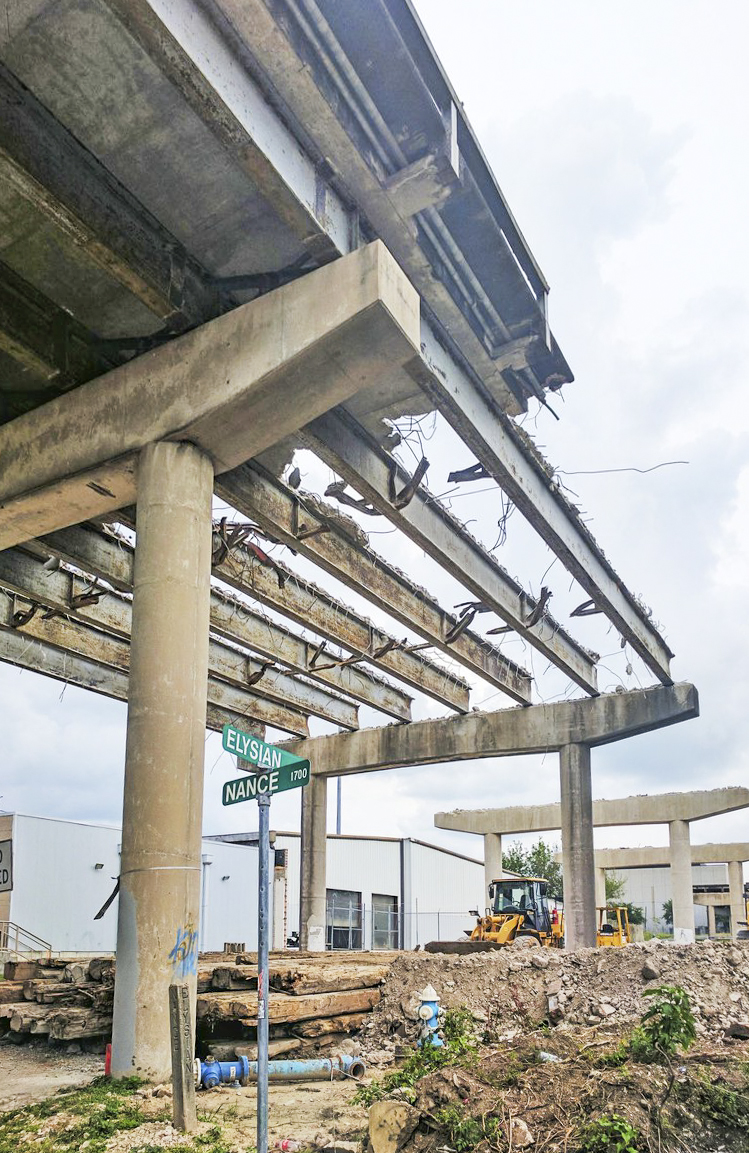 The real value of the long-buried dump uncovered by the ongoing replacement of the Elysian St. bridge over I-10 and Buffalo Bayou, write Doug Boyd and Jason Barrett this week in the Chronicle, is in the opportunity it provides “to document the often-unwritten parts of our industrial heritage.” The dump, apparently built up over the early half of the 1900s in a former gully, serves as a springboard for the authors to talk trash — Houston, they write, was one of the first cities to adopt widespread municipal garbage incineration, and lagged decades behind as most cities chose to stop doing it out of concern for public health. Spots like the one under Elysian St., they add, help fill in the gaps of knowledge of what happened to all the other trash that didn’t end up in a city incinerator or landfill — and who tended to live nearby. [Houston Chronicle; previously on Swamplot]  Photos: Adam J Williams

HARRIS COUNTY GETTING IN ON THE PASADENA REFINERY AIR POLLUTION LAWSUIT ACTION 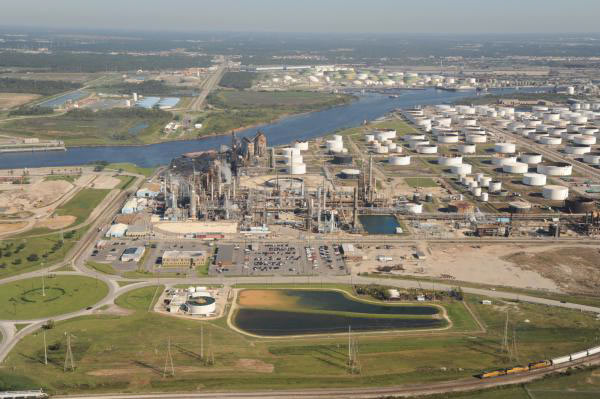 In the wake of the lawsuit the Sierra Club and Environment Texas filed last week alleging that the century-old Pasadena Refining System plant has violated the federal Clean Air Act some thousands of times, Harris County attorney Vince Ryan has filed another suit against the plant.  This one’s to do with the facility allegedly breaking state level environmental laws, Diana Wray writes in this week’s Houston Press; incidents of particular note include last summer’s major sulfur dioxide leak, which briefly shut down both the nearby Washburn Tunnel and the rest of the Ship Channel (while sending Galena Park into duck-and-cover mode). Wray writes that both lawsuits seem mostly geared toward getting the plant to clean up its act; each suit also has the potential to require that some kind of compliance watchdog or overseer be assigned to plant to ensure that it’s doing so. [Houston Press; previously on Swamplot] Photo of Pasadena Refinery Systems, Inc. plant at 111 Red Bluff Rd.: Center for Land Use Interpretation (license)

UNIDENTIFIED CHEMICAL STENCH, HAZE DRIFTING ACROSS TOWN OFFICIALLY NO CAUSE FOR CONCERN 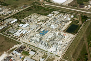 Suggested and mandatory restrictions on hanging around outside were issued by the Memorial Village area’s fire department and by Katy ISD respectively for a while this morning, in response to the acrid odor and haze blowing in some 40 miles across the city from somewhere near the Ship Channel. The Houston emergency response folks say that their monitoring has turned up no air quality red flags, but that anyone who can avoid the stink should probably do so just in case. The particular origin and composition of the odor also still seems to still be up for debate this afternoon: The Albemarle facility at 13000 Bay Park Rd. (shown above) called into the CAER hotline this morning to report that they might be releasing natural gas odorizer throughout the day as their gas facilities got worked on, and LyondellBasell’s Sheldon Rd. facility also sent a message to the CAER line that they would be conducting flaring today in response to a “unit upset,” but no official suspects have been named by the city. The extent of the odor’s inland spread is notably broader than last month’s quickie Valero tank overfill stench incident in Manchester: KHOU reports that some of its viewers on the southeast side of town started calling in about the smell around 10 am, and that “by 11 a.m. the smell and an apparent haze covered most of downtown Houston and the west side, with some reports from as far north as Bush Airport.” [KHOU; previously on Swamplot] Photo of Albemarle facility at 13000 Bay Park Rd.: April R.

Urban wildlife cellphone videographer Christine Wilson sends some footage captured from Allen’s Landing documenting the eons-old nature vs. civilization struggle, which played out earlier this week in the form of tiny ducks dodging their way through the floating trash field where White Oak and Buffalo bayous join up. Wilson caught sight (and sound) of a duck and 4 ducklings struggling across the White Oak outflow toward the Buffalo side of the confluence, which she notes is significantly less debris-spangled. That’s the Harris County Jail in the background for most of the shot, across White Oak from the main building of the University of Houston Downtown. (The footage cuts out mid-scene, but Wilson says the ducks did eventually make it across.)
Video: Christine Wilson
Buffalo Vs. White Oak

WHAT’S SO SPECIAL ABOUT THE PASADENA REFINERY THAT RELEASED 3 MORE TONS OF AIR POLLUTION ON THURSDAY? “We worry about this plant more than we worry about the others,” Air Alliance Houston director Adrian Shelley tells Dylan Baddour after last week’s release of a 6,000-pound cocktail of toxic air contaminants from the Pasadena Refinery System complex, south of Buffalo Bayou just east of the Washburn Tunnel. The release occurred in the wake of a 7-hour power outage at the Petrobras-owned refinery (which played a role in the massive Brazilian corruption scandal that came to light last year); Baddour says this is the 8th contaminant release the company has reported so far this year (and the 65th since 2005). Shelley notes that the plant has a reputation for “large particulate matter (soot) release events that you really don’t see at other Houston refineries,” including the 2 tons of soot released on Thursday with sulfur dioxide gas and other contaminants; Shelley also notes that one of the plant’s key federal permits expired last year, resulting in a $7000 fine from the TCEQ. [Houston Chronicle; previously on Swamplot] Photo of Pasadena Refinery Systems, Inc. plant at 111 Red Bluff Rd.: Center for Land Use Interpretation (license)

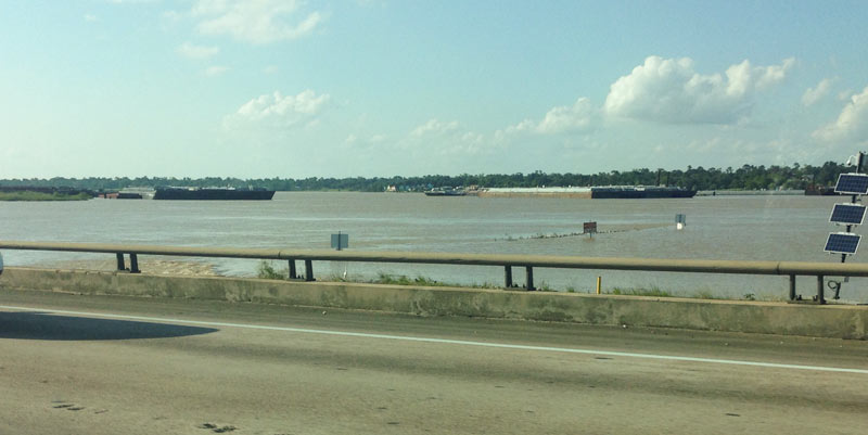
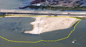 Another effect of the Memorial Day weekend and early June floods: the EPA says it has had to pause some of its latest study efforts near the 1960s industrial waste pits in the San Jacinto river (shown at the top looking a bit more submerged than usual on May 31, facing north from the I-10 bridge). New rounds of sample-taking were triggered by the discovery in December that the Superfund site’s armored cap (which is made of special tarp material held down by a layer of rocks) had a 25-ft.-long hole where the rocks were missing. The EPA also notes that the damage was found within an area of the cap where no tarp was actually initially placed, in light of concerns that the rocks would slide off of it.Â
More Fun With Superfund

GROUP FORMS TO CLEAN UP THE UPPER SAN JACINTO BEFORE IT GETS AS BAD AS BRAYS, BUFFALO, SIMS BAYOUS 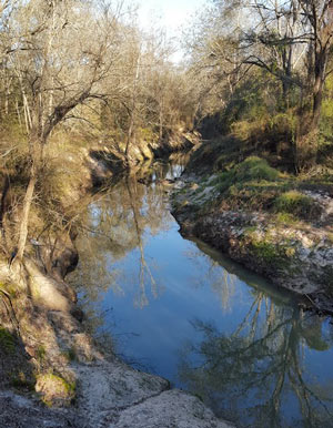 The West Fork of the San Jacinto River (implicated in much of the latest flooding between The Woodlands and Conroe) is in a bacterial “sweet spot”, environmental planner Justin Bower tells Matthew Tresaugue in the Houston Chronicle this week  — more contaminated than is acceptable, Bower says, “but not so much that we can’t do anything about it.” Tresaugue writes that E. coli levels have been trending upward since 2002, in some cases running as high as 10,000 colonies per 100 milliters of water (around 80 times higher than the 126-colony limit recommended by the state of Texas). The river’s water quality problems are multifaceted, but generally boil down to increased development in the watershed causing increased runoff that carries more junk — from human and animals waste to sediment from a nearby gravel mining operation — into the river and ultimately the Lake Houston reservoir (from which the city pulls drinking water). The newly formed West Fork Watershed Partnership has no definite plan yet (other than to work with area stakeholders to develop a plan). But Lisa Gonzalez (VP of the Houston Area Research Council) notes to Tresaugue that not doing anything could allow the West Fork’s water problems to get as bad as those of other major urban waterways in Houston. [Houston Chronicle; previously on Swamplot] Photo of West Fork of the San Jacinto: West Fork Watershed Partnership

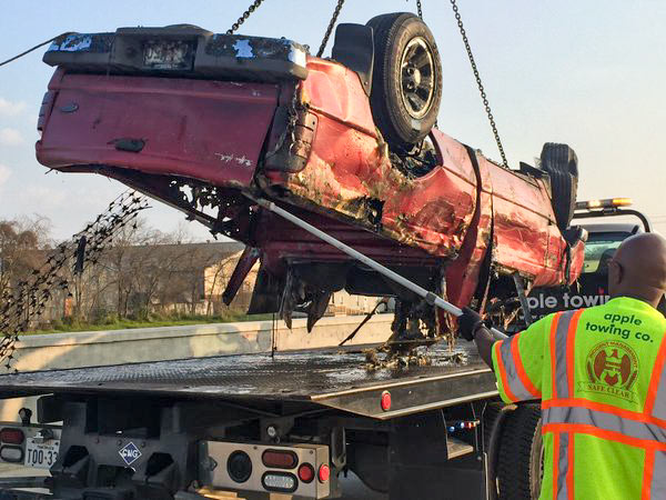
If you are the owner of the bottom half of a red Ford Ranger left in Brays Bayou near Wayside Dr. some time in the last 20 years, your vehicle may be waiting for you in HPD’s impound lot. The pilot program intended to test out a procedure for fishing out the 127-or-so vehicles mapped beneath the surface of a few of Houston’s waterways reeled in its 20th and final car over the weekend before the $49,500 project grant ran out.
The removals started near the Wayside bridge over Brays Bayou in late January, then moved upstream of the crossing of Lidstone St. on the 29th; last Friday, operations jumped down to Sims Bayou to score a few final sets of wheels. Harris County Flood Control District, which oversaw the fishing trips, tweeted that project executives will now meet to discuss future removal plans and compare notes on the process, which involved divers from Saltwater Salvage submerging to attach giant yellow floaties to the sunken vehicles:
Stirring Up Mud in Gulfgate


Some zoomy conceptual renderings of the University of Texas’s coming Houston campus, centered on the largely undeveloped intersection of Buffalo Spdwy. and Willowbend Blvd., made their debut at last month’s Board of Regents meeting, where the intended purchase of land for the project was announced. Buffalo Spdwy. gently winds through the drawings of the new campus to a track and several baseball diamonds along Holmes Rd. (which runs horizontally across the top of the image above).
Although the images are only “concepts”, the pictures do provide a sense of how the campus might unfold: For example, that linear water feature shown at the center of the campus aligns with an existing drainage ditch on the property, and the 3 long, low structures in the foreground are good candidates for parking garages, which will be needed regardless of the new institution’s yet-to-be-decided purpose.
Existing residential communities and industrial parks are here rendered as sparsely-treed fields — the boundary of the land slated for purchase by UT currently houses several apartment complexes on the north side and the Orkin Industrial Surplus facility to the south.
But another conceptual rendering (this one looking northwest across Holmes Rd. towards the distant Williams Tower) shows the campus in place amongst some of its eclectic neighbors:
Welcome to the neighborhood
