03/01/17 1:30pm

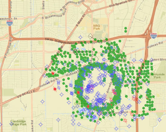
Texas RRC Map of oil wells around Pierce Junction

Update, 6pm: UT announced this afternoon that the Houston campus plans are cancelled — more here.

UT system chancellor Bill McRaven objected in letter form this month to senator and Astrodome scrutinizer John Whitmire’s characterization of the 300 acres UT’s been buying in Houston as “a dump,” the Austin American Statesman’s Ralph K.M. Haurwitz reports. Excerpts from the letter assert that the property, nestled amid the industrial-residential jumble south of the Astrodome, has never in fact been a landfill. Sure, there’s a little bit of contamination from an old polymer facility that needs to be mopped up.  And sure, there may be a healthy smattering of old oil wells from the Pierce Junction boom days, as illustrated by the Rail Road Commission’s map of current and former wells drilled in the area. (UT’s new parcels are just inside the crook of the Holmes Rd.-S. Main St. elbow, to the northwest of the ring of wells drilled around the salt dome’s buried upper reaches.)

But Whitmire’s comments, McRaven’s letter notes, might “lead a listener to conclude that the property and the surrounding area are blighted and unlikely to ever be developed. In fact, the property is adjacent to apartments, neighborhoods, and commercial buildings, and it is highly likely that these adjacent developed lands had similar characteristics.” Meanwhile, the Wildcat Golf Course directly across Holmes Rd. from UT’s campus-to-be actually was a bona fide landfill; the only giveaway is all those rolling hills.

Image: Texas RRC Public GIS Viewer

What Lies Beneath
01/19/16 12:30pm

UT Houston Campus Site, Buffalo Lakes, Houston

The deal is sealed on the University of Texas’s purchase of a 100-acre hunk of land south of South Main St. as of last Friday. The sale marks the first concrete move toward UT’s planned Houston campus, though closings on the parcel patchwork comprising the rest of the 300-ish ac. likely won’t wrap up until early 2017, according to a press release from the school’s Office of Public Affairs.

The sold land is a forested tract northwest of the wiggly intersection of Willowbend Dr. and Buffalo Spdwy.; the property is split along a northwest-southeast diagonal by a linear drainage feature which makes an appearance in those preliminary campus designs (shown from the north in the image above).

That land was owned previously by Buffalo Lakes Ltd., an entity associated with UT grad John Kirksey of Kirksey Architecture. A plan for a Buffalo Lakes master-planned community (see below) was drawn up more than 4 years ago by Kirksey for the same space:

CONTINUE READING THIS STORY

South Main Master Plans
12/14/15 4:15pm

HOUSTON OIL COMPANY WANTS TO BUILD AN ISLAND ON THE ALASKAN COAST Meanwhile, in Prudhoe Bay: Houston-based oil company Hilcorp is seeking permission to construct 23-ac. Liberty Island off the north coast of Alaska by trucking 83,000 cu. yd. of gravel (more than 3 times the volume of the Astrodome) across sea ice to a hole, cut 6 miles offshore above only 19 feet of water. The island would serve as a base for several offshore drilling projects, collectively the first in federal waters off the Alaskan coast. A 5.6-mile undersea pipeline is part of the project. Manmade gravel islands have been in use in the region’s oil fields for decades. [Hilcorp, Associated Press]

12/07/15 4:45pm

PHOTOS OF THE OIL DERRICKS THAT ONCE TOWERED OVER ALL THOSE FAMOUS CALIFORNIA BEACHES Meanwhile, in Los Angeles: Northern California’s redwoods are striking, but the forests of oil derricks that once spread across areas of urban southern California leave a distinct impression as well. The Retronauts at Mashable have pulled together a collection of photos of densely-spaced derricks that loomed over Venice, Long Beach, Signal Hill, and other well-known L.A. areas in the 1920’s and 30’s. The derricks can be seen standing tall in, around, and over urban scenes across the region — between houses, in commercial areas, and at the beach, all the way to the water’s edge. [Mashable]

12/01/15 10:00am

UT Houston Campus Site, Buffalo Lakes, Houston

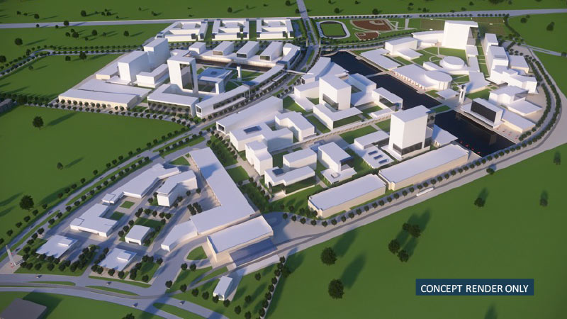
Some zoomy conceptual renderings of the University of Texas’s coming Houston campus, centered on the largely undeveloped intersection of Buffalo Spdwy. and Willowbend Blvd., made their debut at last month’s Board of Regents meeting, where the intended purchase of land for the project was announced. Buffalo Spdwy. gently winds through the drawings of the new campus to a track and several baseball diamonds along Holmes Rd. (which runs horizontally across the top of the image above).

Although the images are only “concepts”, the pictures do provide a sense of how the campus might unfold: For example, that linear water feature shown at the center of the campus aligns with an existing drainage ditch on the property, and the 3 long, low structures in the foreground are good candidates for parking garages, which will be needed regardless of the new institution’s yet-to-be-decided purpose.

Existing residential communities and industrial parks are here rendered as sparsely-treed fields — the boundary of the land slated for purchase by UT currently houses several apartment complexes on the north side and the Orkin Industrial Surplus facility to the south.

But another conceptual rendering (this one looking northwest across Holmes Rd. towards the distant Williams Tower) shows the campus in place amongst some of its eclectic neighbors:

CONTINUE READING THIS STORY

Welcome to the neighborhood