COMMENT OF THE DAY: THE BRIO LATENCY EFFECT ![]() “I moved to Sageglen in 1981 during kindergarten and went to Weber all the way through 6th grade and onto Webster. We played in the ditches catching crawdads, waded through flood waters, and drank the water freely. So many friends lived in Southbend so plenty of time was spent there as well playing throughout the neighborhood on what we thought were playgrounds and neighborhood pools. During the notification process of the contamination, my mother (Chinese and unable to read English at the time) was never aware of any class action suit. I, being a child, only knew we weren’t allowed to drink from the water fountains and didn’t even know what a class action suit or toxic contamination was at the time. Thus, we never signed up for it, nor received any compensation whatsoever. . . After reading all the accounts of vague health issues, I am realizing more and more that my own health issues are pretty much parallel. This cannot be a coincidence. Does anyone know of any sort of data collection on former residents to track the health implications? Or is there a class action suit still available to join; or has anyone filed another considering a lot of these issues are not presenting until adulthood? My biggest concern is: Will these issues be passed down and affect my own child? I just don’t feel this catastrophe and crime against so many people’s health/lives that we are all still/now finding out about should be a ‘closed’ case. We were oblivious kids back then without any idea of how this would affect us in our lives and well-being as adults.” [Marie, commenting on My Toxic Houston Childhood] Photo of Clear Creek near Brio Superfund site: Allyn West
“I moved to Sageglen in 1981 during kindergarten and went to Weber all the way through 6th grade and onto Webster. We played in the ditches catching crawdads, waded through flood waters, and drank the water freely. So many friends lived in Southbend so plenty of time was spent there as well playing throughout the neighborhood on what we thought were playgrounds and neighborhood pools. During the notification process of the contamination, my mother (Chinese and unable to read English at the time) was never aware of any class action suit. I, being a child, only knew we weren’t allowed to drink from the water fountains and didn’t even know what a class action suit or toxic contamination was at the time. Thus, we never signed up for it, nor received any compensation whatsoever. . . After reading all the accounts of vague health issues, I am realizing more and more that my own health issues are pretty much parallel. This cannot be a coincidence. Does anyone know of any sort of data collection on former residents to track the health implications? Or is there a class action suit still available to join; or has anyone filed another considering a lot of these issues are not presenting until adulthood? My biggest concern is: Will these issues be passed down and affect my own child? I just don’t feel this catastrophe and crime against so many people’s health/lives that we are all still/now finding out about should be a ‘closed’ case. We were oblivious kids back then without any idea of how this would affect us in our lives and well-being as adults.” [Marie, commenting on My Toxic Houston Childhood] Photo of Clear Creek near Brio Superfund site: Allyn West
Sign up for the Newsletter
Tag: Water Quality

COMMENT OF THE DAY: THE REAL REASON WHY BUFFALO BAYOU SMELLS AND LOOKS THE WAY IT DOES  “If Buffalo Bayou stunk so much, then no one would have built a bunch of expensive homes all along it (west of downtown). Most of the Houston area’s waste water effluent flows into the Bayou east of downtown anyways. The Clinton/69th plant (the largest in the city) is just east of downtown, and the Sims and Braes plants don’t enter until well past downtown. With that said, I don’t think the treatment plants are the big contributors to the overall unpleasantness of the Buffalo Bayou water (flood events not withstanding). Most of the effluent (when the plants are properly operating) is nearly clear and usually only has an ‘earthy’ odor to it if any at all. I think the big issue with the bayou’s water quality is the regular runoff and trash that flows into it and eventually lines the shores of it all along downtown.” [nmj, commenting on The North Canal, a New Downtown Island, and Other Secret Plans for Downtown Houston’s Future] Photo: Swamplot inbox

Yes, there are spots where Harris County public health officials have determined it’s still not safe to drink the water. And here they are: Areas still under drinking-water advisories are marked in red in the above interactive map; areas where advisories issued after flooding resulting from Hurricane Harvey have already been lifted are marked in green. Click on each area and a popup or panel will provide details. The county promises to update the map every 24 hours. A full-browser-width version of the map is available here.
- 2017: Hurricane Harvey [Harris County Public Health, via Houston Chronicle]
- Harris County Drinking Water Advisory Areas [Harris County Public Health]
Map: Harris County Public Health
Harvey Maps

COULD HARRIS COUNTY SAVE UP SOME FLOODWATER FOR WHEN IT’S REALLY NEEDED? 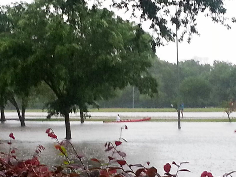 Finding a way to stockpile floodwater during years of plenty, commissioner Jack Cagle tells Mihir Zaveri this week, might not only help to make more water available for use during Houston’s drought years. It might also be a way to check the Houston region’s tendency for subsidence (that slow, permanent sinking that can happen when groundwater is pulled out of Houston’s soft clay layers too quickly). Or maybe, Zaveri adds, it could be used to help keep seawater from being sucked into aquifers as fresh water gets sucked out the other side — as long as doing so didn’t accidentally contaminate those same aquifers with junk from the surface. Who knows? Nobody, yet — but the county commissioners have given the $160,000 okay to a study team to shed light on whether it would be possible, feasible, or advisible for Harris County to pump floodwater underground for storage during major storms. [Houston Chronicle; previously on Swamplot] Photo of Meyerland flooding on Tax Day 2016: Tamara Fish

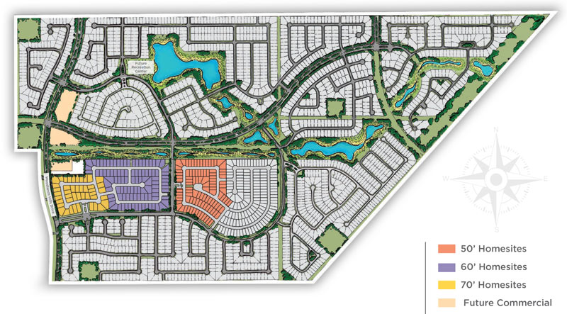
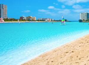 Land Tejas’s Scottish-castle-themed Balmoral development in Humble (sketched out above) is 1 of 2 currently planned Houston-area locations for fake lake maker Crystal Lagoons’s giant outdoor pools, Candace Carlisle reports. The sand-bottomed water feature will be around 1.5 acres, and a similar 8.5-acre pool is planned for a different Land Tejas development (though the actual location of that one hasn’t yet been announced). As it does in the demo lake shown here, the lagoon company plans to keep the water in the pools much clearer than is typical of the area’s bayous and beaches (or even of the stormwater-detaining landscaping lakes typically accompanying such developments) by using a soundwave- and flocculation-based filtration system. Bacteria and algae would also be kept at swimmable levels with a set of sensor-and-Internet-controlled disinfectant injectors.
Humble Lakemakers

RRC: YOUR DRINKING WATER PROBABLY HASN’T BEEN POISONED BY THOSE WELLS WE WEREN’T TRACKING Meanwhile, in Austin: The Texas Rail Road Commission is hiring a geologist to look through the 10,000-or-so permits for oilfield waste disposal wells it’s approved since 1982, in an effort to figure out which ones were drilled into potential drinking water supplies. Kiah Colliers reports this week that the agency (which since 2005 has had nothing to do with railroads) says it’s let through a “handful” of exceptions to the don’t-pump-fracking-liquids-into-water-zones-someone-might-need-later rules, and that they probably aren’t much of a risk, but the agency doesn’t actually know how many times it’s happened (and the EPA doesn’t have records of giving the required OKs). Colliers also notes that even other Texas officials in charge of water quality in frack-heavy areas of the state aren’t necessarily aware that disposal wells are ever allowed near potentially drinkable water supplies, quoting an assistant manager at the Middle Pecos Groundwater Conservation District’s response to a description of the policy as “Now why in the hell would they do that?†[Texas Tribune]
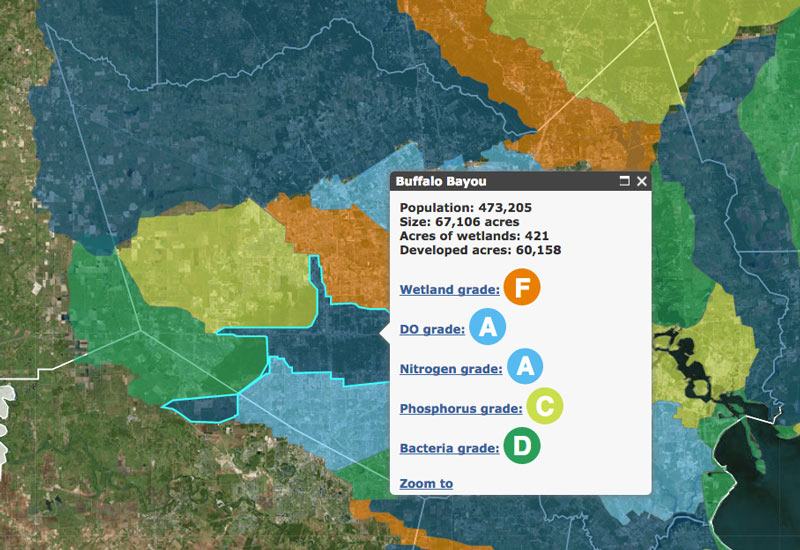
This month the Galveston Bay Foundation and Houston Advanced Research Center released their second annual report card on the health of Galveston Bay, boiling down a wide range of measurements into a series of letter grades. The report card, which looks at the bay itself along with the bayous that drain into it, aims to be easy to understand for folks with or without scientific training. Each of the 6 main categories of grade — including subjects like wildlife population trends, pollution sources, and human health hazards — is broken down with explanations of what specific measurements that rating is based on (and more details in the full report, for those who want them).
The agencies have also put together a Find Your Watershed tool, which lets you check in on how your own part of town is affecting the bay’s GPA. (That’s Buffalo Bayou watershed’s report shown above; the bayou did exceptionally well in dissolved oxygen and nitrogen content this term, but failed wetlands.) You can look up any address and see how the surrounding runoff area measures up in some of the report’s subject categories. (Note that the search tool’s map doesn’t use the same color-by-grade scheme that the rest of the report employs — you’ll have to click on each watershed to see the actual marks).
So how did the bay do this year?
Galveston Bay Schooling

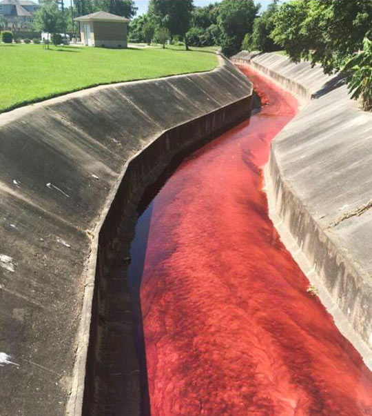
The ditches ran red in the Spring Branch area yesterday as the billowing 4-alarm fire near Laverne St. at Spring Branch Dr. triggered evacuations and shelter-in-place orders across the surrounding areas. The blaze reportedly started in a home-slash-auto-shop on Laverne and spread next door to the A-1 Custom Packaging warehouse (which transfers large quantities of various industrial liquids into smaller bottles for distribution). Some of those stored chemicals (including the bright red petroleum additive visible in the shot above) made their way into drainage ditches and culverts flowing into Spring Branch itself.
The red additive is non-water-soluble and has been getting pushed around by contract clean-up crews downstream to stop the spread. But contractors cannot, the city says, catch the pesticide that also made its way into the same drainage channels, as it dissolves in water. It’s still unclear how much of the 500 gallons or so thought to have been stored at the site made it all the way into Spring Branch (which flows into Buffalo Bayou south of I-10), but some water quality test results are due back later today.
River Running Red

SEWAGE NOW FLOWING PROPERLY UNDER GULF FWY. AGAIN 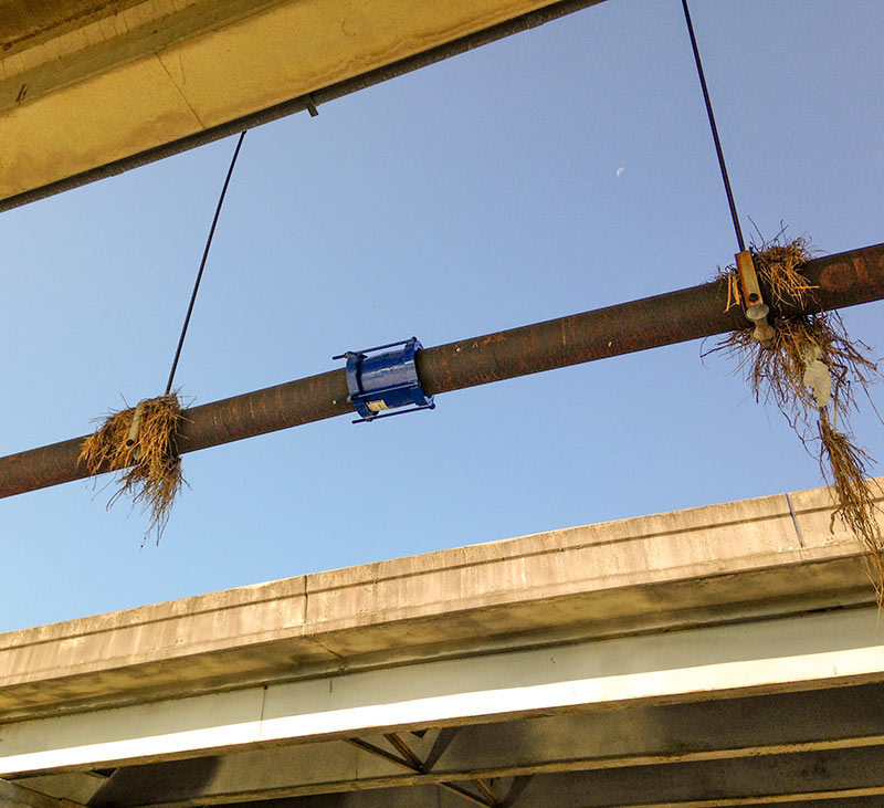 That pipe break spotted underneath an I-45 South overpass leaking what appeared to be raw sewage onto a concrete path adjacent to Brays Bayou last week has now been repaired — or at least covered with a new sleeve. A photo of the fix also shows flood-remnant bouquets still intact along the pipe’s length at the bayou crossing south of Idylwood and just east of Telephone Rd. Photo: Allyn West

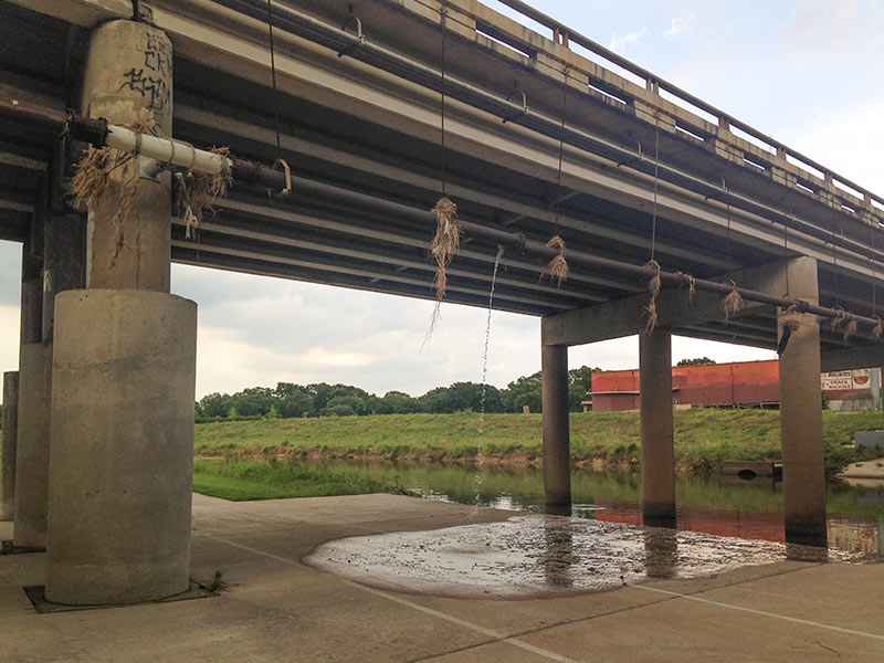
There’s a busted pipe hanging under the Gulf Fwy. overpass as it crosses Brays Bayou, just east of Telephone Rd. and south of Idylwood in the East End. The pics shown here were taken late yesterday afternoon, though some sort of liquid had been seen dripping from the break at various points over the weekend.
Grassy remnants of last week’s high water on Brays Bayou can still be seen hanging from various points along the pipe’s length:
Leftovers

COMMENT OF THE DAY: WHY THE WATER IN YOUR NATURALLY FILTERED BAYOU-SIDE SWIMMING HOLE IS GOING TO BE BROWN  “I’ll bite. Here’s a very simple engineering analysis.
Problems with stream-fed swimming pools in Houston are going to be three-fold:
1) Silt (in engineer-speak, Total-Suspended-Solids or TSS). TSS is treated with sedimentation basins. That can be a large pool (that people don’t swim in) adjacent to the real pool. In water/wastewater treatment plants, a coagulant like alum is usually added to sedimentation basins to make TSS precipitate out quicker. If you’re going to do this with no chemicals, you’ve got to be willing to accept either VERY long treatment times, or only partially successful results. The tiny diameter of the clay particles that make up the TSS in our bayous just flat out won’t come out of suspension without a coagulant, so the water WILL be brown. It’s not necessarily a deal breaker — the water in Galveston’s brown too.
2) Bacteria (in engineer-speak, total coliform count). See here. Usually these are E. Coli, algae, and some protests. ALL streams/lakes/oceans in the entire world have this, even the cleanest and clearest. Realistically, to get an insurance policy to operate, the water’s going to have to be disinfected to some degree. That means chlorination (chemicals), ozonation (chemicals), or UV disinfection. More on UV in a minute.
3) Dissolved oxygen content. You don’t want the water to turn anaerobic. If there’s enough carbon-containing compounds dissolved in the water, the bacteria naturally in the water will eat it rapidly, causing the bacteria to use up all the oxygen that’s already dissolved in the water. This leads to any/all fish in the water suddenly dying off, as well as noxious smells and other really terrible stuff. You can make sure the dissolved oxygen doesn’t drop by filtering out carbon containing compounds (takes chemicals), or using aerators. A dual-way to solve the #2 and #3 issues is by passing the water over a very shallow (less than 6-in. deep) bed of rocks at a fast speed. Think rapids. This lets the water simultaneously re-oxygenate and also absorb huge amounts of UV. This might be the sort of silver bullet that makes this possible in Houston.
So: This is going to be expensive, but it’s probably do-able. However, the water is still going to be brown. Sorry.” [Ornlu, commenting on Bayou Swimming Hole Promoters Jump To Kickstarter To Jumpstart Project] Illustration: Houston Needs a Swimming Hole
“I’ll bite. Here’s a very simple engineering analysis.
Problems with stream-fed swimming pools in Houston are going to be three-fold:
1) Silt (in engineer-speak, Total-Suspended-Solids or TSS). TSS is treated with sedimentation basins. That can be a large pool (that people don’t swim in) adjacent to the real pool. In water/wastewater treatment plants, a coagulant like alum is usually added to sedimentation basins to make TSS precipitate out quicker. If you’re going to do this with no chemicals, you’ve got to be willing to accept either VERY long treatment times, or only partially successful results. The tiny diameter of the clay particles that make up the TSS in our bayous just flat out won’t come out of suspension without a coagulant, so the water WILL be brown. It’s not necessarily a deal breaker — the water in Galveston’s brown too.
2) Bacteria (in engineer-speak, total coliform count). See here. Usually these are E. Coli, algae, and some protests. ALL streams/lakes/oceans in the entire world have this, even the cleanest and clearest. Realistically, to get an insurance policy to operate, the water’s going to have to be disinfected to some degree. That means chlorination (chemicals), ozonation (chemicals), or UV disinfection. More on UV in a minute.
3) Dissolved oxygen content. You don’t want the water to turn anaerobic. If there’s enough carbon-containing compounds dissolved in the water, the bacteria naturally in the water will eat it rapidly, causing the bacteria to use up all the oxygen that’s already dissolved in the water. This leads to any/all fish in the water suddenly dying off, as well as noxious smells and other really terrible stuff. You can make sure the dissolved oxygen doesn’t drop by filtering out carbon containing compounds (takes chemicals), or using aerators. A dual-way to solve the #2 and #3 issues is by passing the water over a very shallow (less than 6-in. deep) bed of rocks at a fast speed. Think rapids. This lets the water simultaneously re-oxygenate and also absorb huge amounts of UV. This might be the sort of silver bullet that makes this possible in Houston.
So: This is going to be expensive, but it’s probably do-able. However, the water is still going to be brown. Sorry.” [Ornlu, commenting on Bayou Swimming Hole Promoters Jump To Kickstarter To Jumpstart Project] Illustration: Houston Needs a Swimming Hole

A LOOK AT SOME OF THE LIQUID POO FLOWING ONTO COLQUITT ST. IN MONTROSE 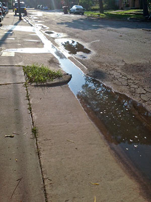 A reader wants to be sure Swamplot readers are alerted — as city inspectors, the HPD’s environmental division, and the property manager have already been, the reader says — to the “recurring” problem of raw sewage flowing out from the Takara-So Apartments at 1919 W. Main St. and into neighboring storm drains. The photo at left, taken on Monday, shows the sewage (“you can smell it”) along Colquitt St., pausing for a bit of sun on its way to lower-lying bayous and waterways. [Previously on Swamplot] Photo: Swamplot inbox

COMMENT OF THE DAY: DON’T YOU DARE TAKE OUR DALLAS SEWAGE AWAY  “More and more cities (recently, San Antonio) are applying for permits to close the loop, and reuse their own treated effluent that their wastewater treatment plants previously discharged into rivers. With most cities in Texas scrambling to find more water sources, and at higher costs, this is the future. The problem is, all of the downstream cities depend on those effluent return flows for their own water systems. In the future, Houston could be going to court to try to force Dallas to keep sending its poop water down the Trinity!” [Semper Fudge, commenting on Yes, You’ve Been Sipping What Dallas Has Been Flushing] Illustration: Lulu

YES, YOU’VE BEEN SIPPING WHAT DALLAS HAS BEEN FLUSHING 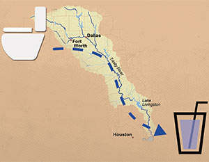 “For the large chunk of population that lives downstream from a big city and whose water supply flows through a river, more than a few drops of the water in their glasses was probably once in someone else’s toilet,” Neena Satija drily notes in her reassuring survey for the Texas Tribune of sewage-treatment projects throughout the state. Her story is worth checking out for the animated image diagramming the flow from a Fort Worth-area toilet to a Houston highball glass alone (excerpted screenshot shown at left, above), but she does stir up some oft-repeated local poop: “Let’s start with Houston, which, as Texas State University professor Andy Sansom says, ‘has been drinking Dallas’ crap for decades,’” she writes. “Wastewater from Dallas and Fort Worth is deposited into the Trinity River, where it flows down into the lakes that supply Houston residents. The wastewater is so clean that it’s credited with helping the Trinity River stay strong during recent years of severe drought.” [Texas Tribune; previously on Swamplot] Illustration: Todd Wiseman/Alessandro Suraci/Luis Prado

WHERE THE POOP IS, IN AND AROUND LAKE HOUSTON  “While some Houston bayous, such as Buffalo and White Oak, have bacteria levels seven times higher than Lake Houston’s watershed, the waters flowing from the San Jacinto River are more vital, said Steve Hupp, Bayou Preservation Association spokesman. . . . Houston’s drinking water is pumped from an area of the lake not contaminated with bacteria.
Only the northwest corner of the lake is impaired, records show. This segment runs from where the river intersects Spring Creek, winds through Humble and past the Kingwood golf course, and ends at the West Lake Houston Parkway bridge.
The bacteria level found in the lake segment exceeds the state standard of 126 E. coli per 100 milliliters of water by 100 percent. Levels on both the river’s west or east forks are lower — exceeding the standard by 25 percent to 56 percent, depending on the segment. Yet a small tributary, Crystal Creek, which feeds into the west fork, has the highest count. It exceeds the state standard by 168 percent.
The communities along the San Jacinto watershed are experiencing a boom in development, especially around the river’s west fork in Montgomery County. Exxon Mobil already has a new 385-acre corporate campus that will be home to 10,000 workers under construction there, while the Boy Scouts recently sold their nearby 2,175-acre camp to a master-planned community developer for a reported $60 million.” [Houston Chronicle ($)] Photo of Lake Houston: Sara Robertson (license)
“While some Houston bayous, such as Buffalo and White Oak, have bacteria levels seven times higher than Lake Houston’s watershed, the waters flowing from the San Jacinto River are more vital, said Steve Hupp, Bayou Preservation Association spokesman. . . . Houston’s drinking water is pumped from an area of the lake not contaminated with bacteria.
Only the northwest corner of the lake is impaired, records show. This segment runs from where the river intersects Spring Creek, winds through Humble and past the Kingwood golf course, and ends at the West Lake Houston Parkway bridge.
The bacteria level found in the lake segment exceeds the state standard of 126 E. coli per 100 milliliters of water by 100 percent. Levels on both the river’s west or east forks are lower — exceeding the standard by 25 percent to 56 percent, depending on the segment. Yet a small tributary, Crystal Creek, which feeds into the west fork, has the highest count. It exceeds the state standard by 168 percent.
The communities along the San Jacinto watershed are experiencing a boom in development, especially around the river’s west fork in Montgomery County. Exxon Mobil already has a new 385-acre corporate campus that will be home to 10,000 workers under construction there, while the Boy Scouts recently sold their nearby 2,175-acre camp to a master-planned community developer for a reported $60 million.” [Houston Chronicle ($)] Photo of Lake Houston: Sara Robertson (license)
