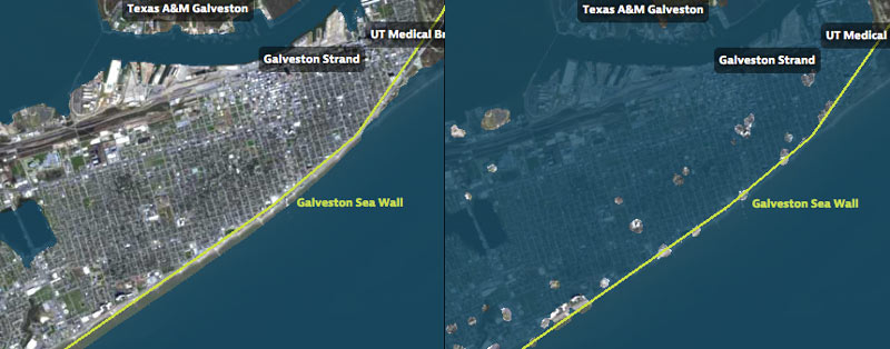
SNEAKING A PEEK AT THE BIG WALLS, BIG GATES ARMY CORPS COULD PROPOSE FOR THE COAST LATER THIS MONTH  On October 26, the agency will single out one of the 4 big proposals it’s been pondering for the Texas coast as the chosen one, reports the Texas Tribune’s Kiah Collier. One of them “calls for the construction of a 17-foot-high levee along the entirety of Galveston Island,” as well as Bolivar Peninsula. Ring any bells? It’s the so-called Ike Dike (also known as the “coastal spine”) that A&M scientists dreamed up about a decade ago in response to the disaster and hypothetically-even-worse disaster that could’ve occurred if Ike had struck 30 miles further west. Another defense against that doomsday scenario that could make it into the proposal: a giant gate structure adapted from Rice’s Jim Blackburn and Philip Bedient’s 2011 idea for a mechanism that’d close before storms to block surge. (They wanted to put it just upstream from the Fred Hartman Bridge; the Corps has number of different spots in mind.) All the plans in the running include a so-called ring levee around Galveston’s bay side to protect it from reverse storm surge, a helping of smaller levees and gates, upgrades to existing flood control structures, and ecosystem restoration projects geared toward creating natural floodwater-fighting barriers. [Texas Tribune; previously on Swamplot] Map indicating proposed Alternative A plan: U.S. Army Corps of Engineers
Sign up for the Newsletter
Tag: Galveston Bay

SCENIC UPPER TEXAS COASTAL SWAMPS, BEACHES, PLANTATIONS A LITTLE CLOSER TO GOING NATIONAL 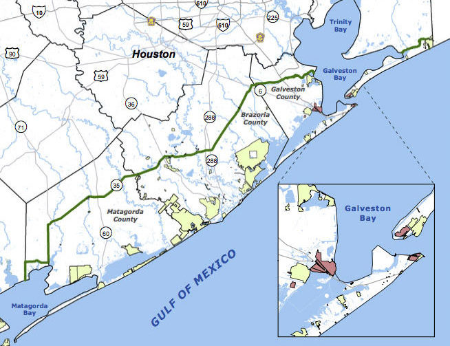 Jefferson County’s commissioners are the latest to give a formal thumbs up to a proposal for the Lone Star Coastal National Recreation Area, which would bundle together a patchwork of parks, historical sites, and variously refinery adjacent nature preserves from the Bolivar peninsula down to Matagorda Bay. The concept for a regional rec zone was developed shortly after Hurricane Ike’s big splash on the Texas coast in 2008: researchers noticed that some of those larger patches of undeveloped wetlands helped buffer storm surge damage, and started looking at whether keeping them around could be profitable in other ways. No new land would be scooped up for inclusion in the 4-county zone, unless it were offered voluntarily — but the whole region would be marketed under the National Parks Service’s banner as a package to birdwatchers, beachgoers, Strand-walkers, and the like. The proposed area would still need some level of National Parks Service staff, and approval from Congress — which is currently considering major cuts to the Department of the Interior’s budget. [Beaumont Enterprise; Houston Chronicle] Map of proposed Lone Star Coastal National Recreation Area: LSCNRAÂ

COMMENT OF THE DAY: YOU CAN LOVE THE BAY YOU’RE WITH AND STILL HARBOR SHIP CHANNEL FANTASIES  “I know that Galveston Bay is the economic engine of the Houston area, but it’s fun to ponder what 42 prime bayside acres could be other than a barge staging area, or what the bay woulda/coulda been had oil not been discovered nearby. Coulda been San Francisco, got Can Cerisco.” [JoeDirt, commenting on Kirby To Lease New Ship Channel Barge Parking Area, Pay for Barge Collision Oil Spill] Illustration: Lulu

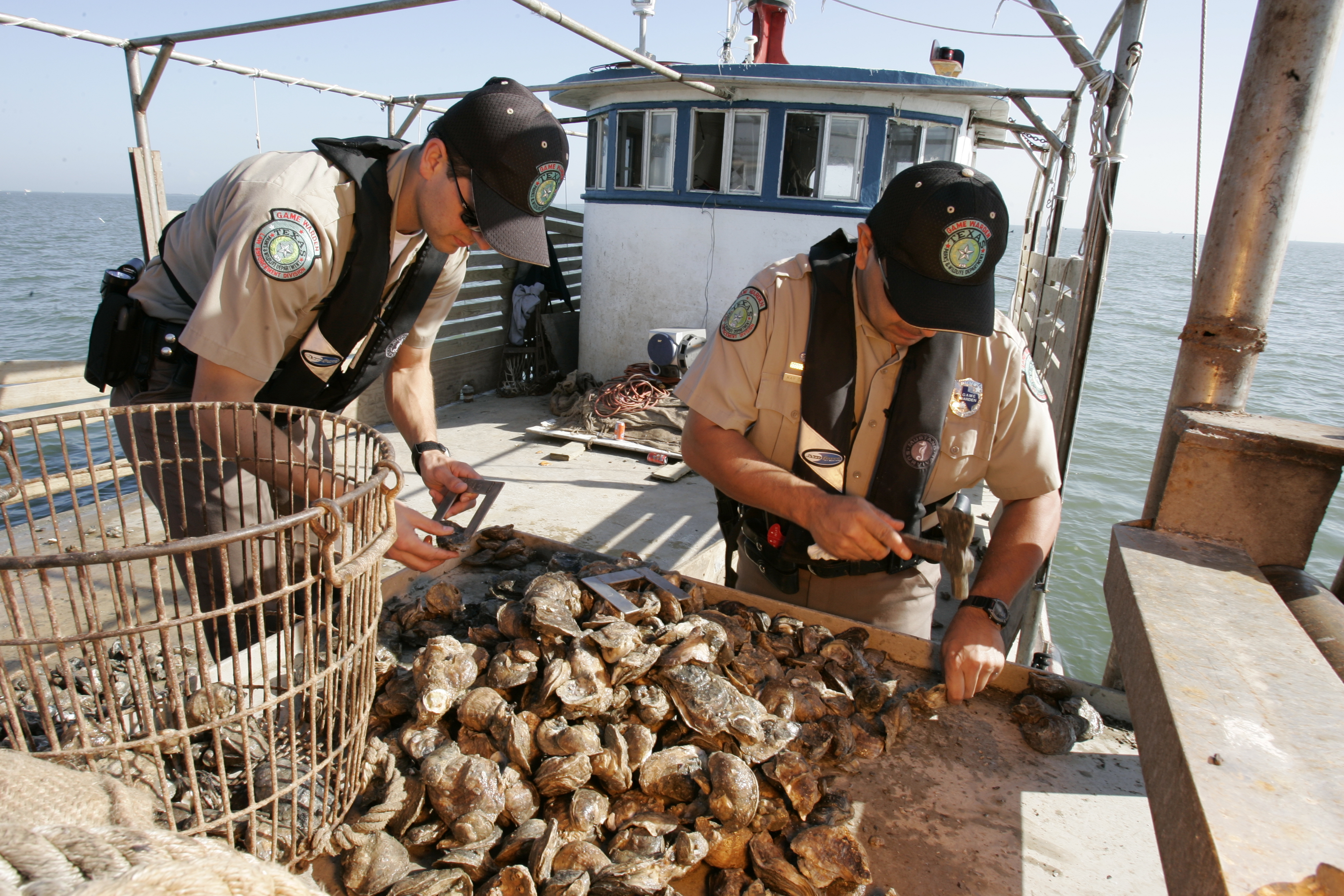
COMMENT OF THE DAY: THE PRICE OF SAVORING THAT MOUTHWATERING HOUSTON INDUSTRIAL FLAVOR  “I always found that Galveston Bay oysters had a slight metallic tinge to them (as compared to oysters from Matagorda or San Antonio Bays) — and actually, I quite like it. Perhaps it could be said that a true appreciation for Galveston Bay’s environs doesn’t come without some carcinogenicity. Oh well — so be it.” [The Niche, commenting on Oyster Tycoons Fight over Baybottom Territory as Reefs Recover from Flooding] Image of state game wardens examining oysters: TPWD

OYSTER TYCOONS FIGHT OVER BAYBOTTOM TERRITORY AS REEFS RECOVER FROM FLOODING 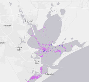 More action is expected next week in the Galveston County courtroom hosting part of the ongoing underwater real estate fight involving some of the biggest names in the local oyster fishing industry, writes Harvey Rice. At stake: oyster rights on 23,000 acres of subsea land leased out in 2014 by the Chambers-Liberty Counties Navigation District — including some areas already leased out to other fishermen by Texas Parks and Wildlife. The move spurred several lawsuits, first from the lessee’s industry competitors and (former) friends, and later from the state of Texas itself; the issue has since worked its way to several appeals courts, one of which stopped the case from being moved to Chambers County. And even the oysters themselves have faced a dramatic few years, Rice notes, between the recent Houston–area flooding (which sent enough freshwater runoff to the coast to drastically alter the bay’s salt levels) and the stretch of drought before that (which let salinity get too high). [Houston Chronicle] Map of oyster habitat in Galveston Bay: General Land Office

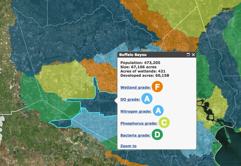
This month the Galveston Bay Foundation and Houston Advanced Research Center released their second annual report card on the health of Galveston Bay, boiling down a wide range of measurements into a series of letter grades. The report card, which looks at the bay itself along with the bayous that drain into it, aims to be easy to understand for folks with or without scientific training. Each of the 6 main categories of grade — including subjects like wildlife population trends, pollution sources, and human health hazards — is broken down with explanations of what specific measurements that rating is based on (and more details in the full report, for those who want them).
The agencies have also put together a Find Your Watershed tool, which lets you check in on how your own part of town is affecting the bay’s GPA. (That’s Buffalo Bayou watershed’s report shown above; the bayou did exceptionally well in dissolved oxygen and nitrogen content this term, but failed wetlands.) You can look up any address and see how the surrounding runoff area measures up in some of the report’s subject categories. (Note that the search tool’s map doesn’t use the same color-by-grade scheme that the rest of the report employs — you’ll have to click on each watershed to see the actual marks).
So how did the bay do this year?
Galveston Bay Schooling


That’s Galveston Island going for a dip in the before-and-after captures above, from a set of interactive timelapse maps released by the Texas Tribune and ProPublica yesterday (along with several articles by authors Kiah Collier and Neena Satija). The new maps model flooding across the Houston region during Hurricane Ike — as well as what would have happened if Ike had actually hit just south of Houston, as meteorologists initially expected.
The maps are your chance to relive an old disaster, or to see how many of your neighbors you can take out with a hypothetical-but-not-unrealistic future storm: users can pick between Ike, south-er Ike, a storm 15% stronger than Ike (nicknamed Mighty Ike), and a modeled 500-year storm (which the article suggests may actually be a concern on the every-few-decades-or-so level; ‘500-year’ has always meant ‘a low probability in any year’, and climate change is shaking up old modeling assumptions). The graphics also include a few dramatic face-offs:Â Mighty Ike and the 500-year storm VS. 2 of the miles-long multi-billion-dollar coastal protection projects being studied for the upper Texas coast.
You can even search for your home address in the map system to see what flood levels might look like in your own back yard. Here’s what the maps show happening to the Clear Lake, Seabrook, and League City areas at the peak of the 500-year storm model’s storm surge, which the article says is a “not if, but when” event:
Hell and High Water

BUILDING A MONUMENT TO GATED FLOOD CONTROL AND TOURISM  Protecting the Ship Channel during an Ike-like (or worse) storm surge has led some to propose a big dike, others a big gate. But UH professor of urban planning Tom Colbert doesn’t see why we couldn’t trouble ourselves to make such protection a real sight to see too: “Colbert likes the idea of . . . connecting the Centennial Gate and its levees to the proposed Lone Star National Recreation Area, undeveloped land that would both attract ecotourists and slow floodwaters,” reports the Houston Chronicle’s Lisa Gray: “I remembered one drawing I’d seen in [Colbert’s] PowerPoint show: Happy tourists, paddling kayaks past the Hartman Bridge, on one of the byways out of the big ships’ path, waterbirds and wetlands all around. Colbert motioned southeast, toward the Ship Channel’s mouth, toward Barbours Cut, the other possible location for the floodgate. There, he said, the levees would cross the channel’s water, connecting the Ship Channel’s artificial islands — made from dirt dredged from the channel — to the shore. Enough room could be left on top of the levee for a hiking path or even for car access; for the first time, it would be possible for people to get to the Atkinson Island Wildlife Management Area — a bird mecca on manmade land — without a boat. You could even, he notes, build a tourist destination atop one of those islands: He proposes a monument to Houston, the gateway to North America, the place where nature meets industry. In some drawings, just to give people the idea, he plunks the Statue of Liberty atop a Ship Channel island.” [Houston Chronicle ($); previously on Swamplot] Photo of Fred Hartman Bridge: Chuck Wilkson


What could possibly have been worse than Hurricane Ike? Super Ike, a stronger hurricane aimed 30 miles further west, causing a larger storm surge, more deaths, and significantly greater damage to Houston’s industrial infrastructure. To protect against that hypothetical $100 billion threat, a Rice University team is recommending some bolstered defenses for the region. Included among the suggestions: a “moveable gate structure” just upstream from Baytown’s Fred Hartman Bridge, to block the Ship Channel and San Jacinto River from rising waters in Galveston Bay (pictured above); elevating Hwy. 146 along the west edge of Galveston Bay so that it forms a levee protecting much of La Marque, Dickinson, League City, Clear Lake, and La Porte; a “baywall” to protect Galveston Island’s backside from sneaky storm surge waters; and preserving a 130-mile-long stretch of existing coastal wetlands between High Island and Matagorda as a recreation area and when-needed storm barrier.

GALVESTON BAY OIL SPILL: JUST A LITTLE TOPPING-OFF ACCIDENT According to the Coast Guard, the three-quarter-mile-long oil slick that made a few residents of San Leon feel a bit queasy, then washed up on the rocks at April Fool Point a week ago came from a spill caused by a Liberian-flag oil tanker — almost a week and a half earlier. The Omega Emmanuel reported a 50-gallon spill on February 8th as it was docked off Bolivar and taking on fuel from a barge. But the Coast Guard only tied the fuel oil to the tanker after environmental testing was completed this past Wednesday. “The cleanup ‘is complicated because the oil is embedded in the rocks,’ [Coast Guard petty officer Prentice] Danner said. ‘It takes slushing (agitation) to get it out, so I can’t speculate on how long it will take.'” Is that the same goo off the coast of Bacliff too? [Ultimate Clear Lake; previously on Swamplot]

Update, 2/24: Oh, just 50 gallons, they’re saying now.
Coast Guard officials have yet to determine the cause of the “oily sheen” that appeared in Galveston Bay last week, but the cleanup has continued for several days and workers have still not identified the source. A three-quarter-mile-long sheen off the coast at Sixth St. in San Leon “was making some residents feel ill” when it appeared last Thursday, according to a report in the Galveston County Daily News. About 30 workers from Phoenix Pollution Control and Environmental Services were still cleaning up oily goo from a mile-long stretch of shoreline near April Fool Point at San Leon’s southern tip, a Coast Guard official told the Chronicle‘s Robert Stanton today. But the photo above, showing the slick on rocks at Bacliff — on the far northwestern side of the same peninsula — was sent to abc13 earlier today by a photographer who comments that workers didn’t want pictures taken. Another photo submitted by the same person appears to show boom deployed in the water off Grand Ave.:

HIGHER POWERS OF THE HOUSTON-GALVESTON REGION Environmental attorney Jim Blackburn gets religion: “At AA, they told me that that I had to admit that I was powerless over alcohol. They also told me that I needed to acknowledge a ‘higher power’ which was described as a power greater than myself that would provide me with spiritual strength sufficient to give me the ability to change. Well – I fought both concepts, particularly that of a higher power. It seemed like capitulation, that I had to return to the religion within which I was raised and from which I had fled. And then at a meeting one day, a young man said that his higher power was a METRO bus. The METRO bus as a higher power made me smile and it allowed me to loosen up and think more creatively. At this time, I was doing work on Galveston Bay and had a good feeling about the bay, so I chose Galveston Bay as my higher power, a truly life-changing event.” [Blackburn & Carter, via OffCite]