
WEIGHING THE OPTIONS ON KEEPING HOUSTON RELATIVELY DEVASTATING-STORM-SURGE-FREE 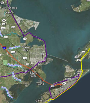 A quick key to this map of Galveston Island and southwest Galveston Bay: (1) The yellow line shows the path of the ‘coastal spine’, a 60-mile seawall that would run along Galveston Island to Bolivar peninsula, with an enormous set of floodgates between the landmasses. The spine is a much-argued-over proposal to combat freakout-worthy flooding from future hurricane storm surges that could threaten the nation’s tennis ball supply. (2) The purple line shows an alternate plan proposed by the Gulf Coast Community Protection & Recovery District: put a ring around the city of Galveston (not the island itself), and place or expand levees along the mainland. Kiah Collier writes in the Texas Tribune yesterday that the GCCPRD’s recently released report makes a regional consensus on what to build way less likely any time soon: The study group says that the levee plan “would provide a nearly equivalent level of protection while costing several billion dollars less [than the coastal spine]. The catch: several Houston-area communities on the west side of Galveston Bay, including Kemah, La Porte, Seabrook, Morgan’s Point and San Leon, would be left outside the dike.” Public meetings with the GCCPRD are planned for the end of the month in Galveston, League City, Lake Jackson, and Orange. [Texas Tribune; previously on Swamplot] Map of coastal protection alternatives: Gulf Coast Community Protection & Recovery District report
Tiki Island is like, “I vote for the yellow one.”
Well, there is already a levee system for Texas City and at some point SH 146 really ought to get rebuilt, providing an opportunity to make it fulfill a dual purpose both as transportation and flood control. Moreover, a strong hurricane is still going to blow the water already in Galveston Bay ashore so the coastal spine may prevent catastrophic scenarios but it does not provide 100% protection. Neither does the GCCPRD plan, which leaves the most exposed areas totaly unprotected rather than modestly protected, but at first glance it may appear to be the most cost-effective solution.
All the same, If the right storm hits the bay in the right spot, the Houston Ship Channel and various other channels may very well become silted in. Its not exactly an easy channel to navigate even as it is; there are massive anomalies between its authorized depth and its true depth in many places and the port pilots are really a very remarkable set of mariners for coping with that. But if its blocked outright, that is a big problem that cannot quickly be overcome. Meanwhile, if Texas City is to be protected from that storm then its levees must be rebuilt completely. Galveston needs both a new seawall and new levees which mar its wharf-side landscape. Gates have to be built along Galveston’s wharves, at Dollar Bay, at Dickinson Bayou, at Clear Creek, and at the Ship Channel entrance.
If the coastal spine is built then Texas City’s levees and the levees around private refineries are adequate, Galveston and Tiki Island are protected, and any reasonable rebuild of SH 146 can be done at a modest elevation and provide complete protection for communities behind it. If additional protection would be warranted anywhere, it would be to Clear Lake. I can easily envision that; but it would not need to entail as substantial a project with the coastal spine in place as if it were not.