ARMY CORPS’ FIRST PUBLIC IKE DIKE DISCUSSION IS TOMORROW  Tomorrow, the Army Corps will hold a public meeting in Port Lavaca about the Ike Dike it proposed last month. The meeting — the first of 6 planned between now and April — will give the agency an in-person opportunity to defend the modeling system underlying its $30 billion recommendations, which took some heat earlier this month from Rice U. scientists who claimed it didn’t take into account all those 100-year events that keep happening every few years. Since then, the Corps has told the Chronicle’s Nick Powell that isn’t true, adding that numerous key tweaks have brought the system up to date from FEMA’s earlier model, used in flood insurance mapping projects. The public comment period for the proposal remains open until mid-January. [Houston Chronicle ($); previously on Swamplot]
Sign up for the Newsletter
Tag: Army Corps of Engineers

SNEAKING A PEEK AT THE BIG WALLS, BIG GATES ARMY CORPS COULD PROPOSE FOR THE COAST LATER THIS MONTH
On October 26, the agency will single out one of the 4 big proposals it’s been pondering for the Texas coast as the chosen one, reports the Texas Tribune’s Kiah Collier. One of them “calls for the construction of a 17-foot-high levee along the entirety of Galveston Island,” as well as Bolivar Peninsula. Ring any bells? It’s the so-called Ike Dike (also known as the “coastal spine”) that A&M scientists dreamed up about a decade ago in response to the disaster and hypothetically-even-worse disaster that could’ve occurred if Ike had struck 30 miles further west. Another defense against that doomsday scenario that could make it into the proposal: a giant gate structure adapted from Rice’s Jim Blackburn and Philip Bedient’s 2011 idea for a mechanism that’d close before storms to block surge. (They wanted to put it just upstream from the Fred Hartman Bridge; the Corps has number of different spots in mind.) All the plans in the running include a so-called ring levee around Galveston’s bay side to protect it from reverse storm surge, a helping of smaller levees and gates, upgrades to existing flood control structures, and ecosystem restoration projects geared toward creating natural floodwater-fighting barriers. [Texas Tribune; previously on Swamplot] Map indicating proposed Alternative A plan: U.S. Army Corps of Engineers

DIGGING UP THE LATEST ADDICKS AND BARKER RESERVOIR DIRT  The Army Corps of Engineers is exploring the possibility of deepening the Addicks and Barker reservoirs in order to increase their floodwater capacities. The Chronicle’s Mihir Zaveri digs up a request the Corps posted online quietly in January for specifics on how to remove soil from the reservoirs. The notice says the Corps is “evaluating the level of interest” from contractors, government agencies, and others “to allow for the beneficial use of material by interested parties while increasing capacity of the Government project.” Respondents are asked how much how much soil they would remove from the reservoirs, what methods they’d use to collect and transport it, where they’d deposit it, and how long the work would take. The deadline for responding to the agency was last Thursday. [Houston Chronicle; posting] Photo of American Shooting Centers and Millie Bush Dog Park off Westheimer Pkwy. in Barker Reservoir, flooded after Memorial Day, 2015: U.S. Army Corps of Engineers [license]

THE ARMY CORPS SAW ALL YOUR ADDICKS AND BARKER LAWSUITS COMING — 23 YEARS AGO  A 1995 Army Corps of Engineers memo obtained by the Chronicle shows that the agency considered the possibility that dozens of lawsuits could be filed against it by flooded homeowners both upstream and downstream from the Addicks and Barker dams. “Given the nature of the expensive homes that would be flooded and the quality of legal representation these owners could afford, there is always the possibility of an adverse ruling,” but the likelihood of such an outcome would be low, it concluded. Those downstream from the reservoirs would have a weak case, the memo argued, because their home values benefit from the dams in the first place. And those upstream — inside the Addicks and Barker flood pools — would have to prove that flooding wasn’t just sporadic, but “frequent and inevitably recurring to amount to a taking of interest in property.” Regardless, says the document, “it would be prudent for Harris County to make sure owners, future developers, and future buyers are put on notice that they are in a reservoir.” That didn’t happen. [Houston Chronicle; memo] Photo of Barker Reservoir Near Addicks Clodine Rd. after Harvey: Kyle Steck

TERRY HERSHEY, 1922-2017 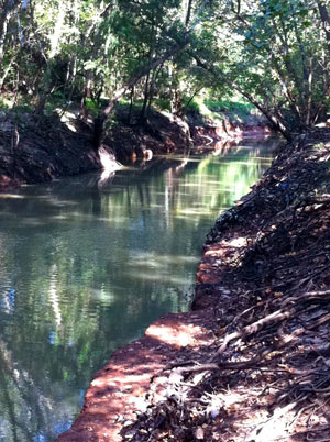 The stretch of Buffalo Bayou running between the Addicks and Barker reservoirs and Shepherd Dr. looks the way it does today in large part because Terry Hershey and some friends spotted the unannounced work to pave and reroute the bayou — and raised some hell about it with the county, the Corps of Engineers, and others. The early actions of Hershey and her associates stopped the pave-over, led to the founding of what became the Bayou Preservation Association, aided the passage of the National Environmental Policy Act (which requires public involvement in projects that could impact the environment), and helped to catalyze Houston’s environmental movement. Hershey’s legacy includes founding, laying groundwork for, and participating in many other organizations to protect green space and environmental quality in Houston and throughout the state, many of which are still active today; the 6-mile park along Buffalo Bayou between Hwy. 6 and Beltway 8 is named for her. Hershey passed away today at age 94. [Houston History, Houston Chronicle] Photo of Terry Hershey Park: Save Buffalo Bayou

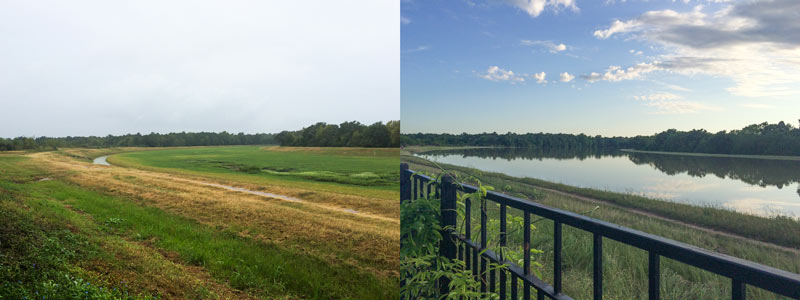
A water-watching reader sends some south-facing photos from yesterday evening (right) and last October, comparing views over the fenceline of the 400-ft.-wide diversion channel at the northern edge of the Addicks reservoir. The channel picks up most of the flow from Langham and Horsepen creeks where they join up as they flow south into Addicks. The 400-ft.-wide floodway was dug in the 1980s; the flow usually lurks down in the narrow channel seen in the shot on the left.
The scene above is less than a mile east of Bear Creek Village, where water is now moseying into neighborhoods from the western edge of the reservoir (and washing some wildife and livestock around). The Army Corps of Engineers has been releasing water from both Addicks and Barker dams to minimize the pooling (and relieve stress on the dam structures themselves) — but those releases have to be done slowly enough to avoid causing additional flooding downstream along Buffalo Bayou. Meanwhile, water is still flowing into the reservoirs from western watersheds; the measured levels behind the 2 dams topped all previous water level records and normally allowed pooling limits in the reservoir by Tuesday, and has been rising since. Here’s a shot of water gushing out through some of the gates of the Barker dam this afternoon:
Drinking It In, Spitting It Out

The Army Corps of Engineers is holding a public meeting amid this evening’s predicted thunderstorms to chat about the recently begun replacement work on the Addicks and Barker dams, which have each won the rare and highly distinguished label ‘extremely high risk’ through a combination of structural issues and close proximity to Houston. For those not planning to flood the Corps with questions and comments in person, there’s a somewhat-outdated online survey, as well as an online map of updates on the project’s progress. Work to replace the outlet structures of the dams began in February, and is expected to take about 4 years.Â
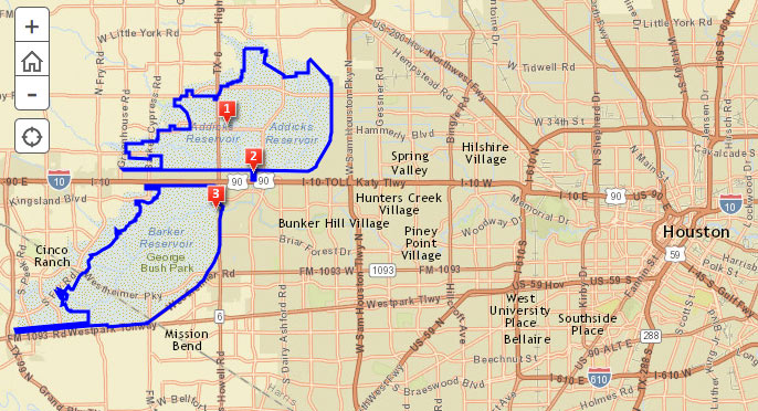
The 2 reservoirs, spread out across 26,000 acres on either side of the Katy Fwy. near Highway 6, starred in the Sierra Club’s 2011 lawsuit over the construction of Segment E of the Grand Parkway through the reservoirs’ catchment area. The club claimed development spurred by the road could send major additional runoff to the reservoirs, increasing the chance of dam failure, which Dave Fehling of Houston Public Media reports “could do an estimated $60 billion dollars in damage to downtown Houston, to industries along the Houston Ship Channel, [and] even to the Texas Medical Center.” The judge didn’t stop construction of Segment E, but did order new studies on its potential flooding impacts.
Addicks and Barker Reservoirs
