ALL THE DAMS AND MAGIC WETLANDS CAN DO  Big, fat, cleared floodplains are the best way to handle a very large storm, explains wetlands scientist John Jacob — because nothing else is going to: “An average rainfall of 35 inches over all of Harris County (Harvey) is just over 1 trillion gallons. At most, there are about 50 billion gallons of stormwater detention capacity in Harris County wetlands (no one has measured this — I had to make some very broad assumptions). So that means that the wetlands at best could handle about 5% of the total volume of Harvey rainfall. In the large scheme of things, it’s not much. And the scheme of things in Harvey is indeed very large.
So much for the magic wetlands. But what about our engineered drainage system? I calculate a somewhat larger detention capacity — between our large US Army Corps of Engineers Katy Prairie reservoirs (~400,000 acre-ft) and Harris County Flood Control District detention (about 34,000 acre-feet), we have about 130 billion gallons of detention volume. More than what we have for wetlands, but still only about 14% of Harvey. As we painfully saw, also overwhelmed.
And what of green stormwater infrastructure — rain gardens, bioswales, green roofs, etc.? We don’t have any good numbers here, but you can be sure that even if these practices were widespread, the volume would be very small relative to wetlands and detention basins. These practices are designed to capture at best a 2 inch storm.” [Watershed Texas] Photo of Willow Waterhole Greenspace: Luz (license)
Big, fat, cleared floodplains are the best way to handle a very large storm, explains wetlands scientist John Jacob — because nothing else is going to: “An average rainfall of 35 inches over all of Harris County (Harvey) is just over 1 trillion gallons. At most, there are about 50 billion gallons of stormwater detention capacity in Harris County wetlands (no one has measured this — I had to make some very broad assumptions). So that means that the wetlands at best could handle about 5% of the total volume of Harvey rainfall. In the large scheme of things, it’s not much. And the scheme of things in Harvey is indeed very large.
So much for the magic wetlands. But what about our engineered drainage system? I calculate a somewhat larger detention capacity — between our large US Army Corps of Engineers Katy Prairie reservoirs (~400,000 acre-ft) and Harris County Flood Control District detention (about 34,000 acre-feet), we have about 130 billion gallons of detention volume. More than what we have for wetlands, but still only about 14% of Harvey. As we painfully saw, also overwhelmed.
And what of green stormwater infrastructure — rain gardens, bioswales, green roofs, etc.? We don’t have any good numbers here, but you can be sure that even if these practices were widespread, the volume would be very small relative to wetlands and detention basins. These practices are designed to capture at best a 2 inch storm.” [Watershed Texas] Photo of Willow Waterhole Greenspace: Luz (license)
Sign up for the Newsletter
Tag: Dams

COMMENT OF THE DAY: THE MORE WEST HOUSTON FLOODS, THE MORE IT STAYS THE SAME  “Why does it matter? Even after the flood, I am okay with them building there on private land. Flood risk is just one of a million things that you should look at when buying a home. Heck, even knowing what we know now, I might still buy there in the right situation. If I was looking to buy a home in that general area, and the only way I can get one is to build one on the far back end of the reservoir, I would still do it today. Even after we calibrate the models to include the recent rainfall events, we will still find that this is an outlier.” [Rex, commenting on How It Came To Pass That Hundreds of Families Purchased Homes Inside Houston’s Reservoirs; previously on Swamplot] Map of subdivisions in or along the edge of the Addicks and Barker reservoirs: ProPublica

WAIT, DID THE 2008 RECESSION UP THE CHANCES OF A FUTURE HOUSTON CHEMICAL CATASTROPHE? 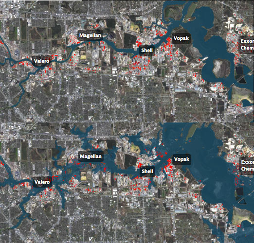 Roy Scranton imagines “a wave of water sweeping toxic waste into playgrounds, shops and houses” in Magnolia Park in his op-ed this morning, written after touring the Ship Channel and speaking with the local A&M and Rice research teams pushing for variations on a series of region-scale coastal barriers to hunker down behind whenever the next gigantic hurricane hits the Houston region, in hopes of avoiding deadly flooding and catastrophic chemical spills. But the researchers tell Scranton that pushing for federal and state funding for a response is a slow endeavor; Jim Blackburn (a main player on the Rice team) tells Scranton that he’s “heard more than one person say our plan is to wait until the next hurricane comes, then depend on guilt money from Washington to fix the problem.” Scranton writes that the best chance for that guilt money so far might have been in 2008, when Hurricane Ike landed just 30 miles northeast of the zone that modelers say could have caused thousands of deaths and irreparable ecological devastation to the area, on September 13th — 2 days before the Lehman Brothers filed for bankruptcy, pulling global attention and national funds to other issues as markets began to crash. [NY Times; previously on Swamplot] Model maps of potential storm surge flooding along the ship channel, with chemical storage marked in red: Texas Tribune

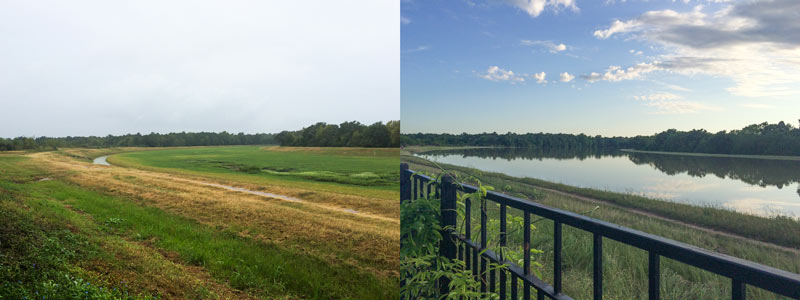
A water-watching reader sends some south-facing photos from yesterday evening (right) and last October, comparing views over the fenceline of the 400-ft.-wide diversion channel at the northern edge of the Addicks reservoir. The channel picks up most of the flow from Langham and Horsepen creeks where they join up as they flow south into Addicks. The 400-ft.-wide floodway was dug in the 1980s; the flow usually lurks down in the narrow channel seen in the shot on the left.
The scene above is less than a mile east of Bear Creek Village, where water is now moseying into neighborhoods from the western edge of the reservoir (and washing some wildife and livestock around). The Army Corps of Engineers has been releasing water from both Addicks and Barker dams to minimize the pooling (and relieve stress on the dam structures themselves) — but those releases have to be done slowly enough to avoid causing additional flooding downstream along Buffalo Bayou. Meanwhile, water is still flowing into the reservoirs from western watersheds; the measured levels behind the 2 dams topped all previous water level records and normally allowed pooling limits in the reservoir by Tuesday, and has been rising since. Here’s a shot of water gushing out through some of the gates of the Barker dam this afternoon:
Drinking It In, Spitting It Out
