10/31/16 12:00pm

Houston Map of risk management plan facilities from UCS/tejas

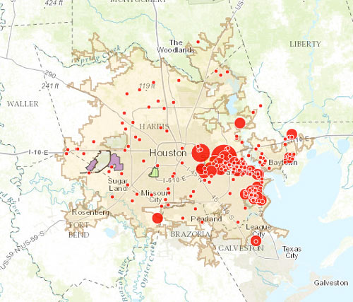
The little and not-so-little red dots on the map above show off sites on the EPA’s list of plants and refineries required to have a Risk Management Plan due to their potential for accidental hazardous chemical releases — with the larger dots showing the places that have already had an accident (or, in some cases, as many as 43). Clicking each dot will tell you what the facility’s name is, as well as how much toxic or flammable material it stores on site (to the nearest thousand pounds or so).

The Union of Concerned Scientists and t.e.j.a.s. put together the interactive map as part of a report released late last week, which compares the EPA’s data on air quality and cancer rates in a few neighborhoods on the west side of town (specifically in Bellaire and in the West Oaks and Eldridge area, just inside Hwy.6 near the Barker reservoir) with the same data in a couple of east side spots (Galena Park and Manchester).

CONTINUE READING THIS STORY

Sniffing It Out
10/07/16 10:30am

WAIT, DID THE 2008 RECESSION UP THE CHANCES OF A FUTURE HOUSTON CHEMICAL CATASTROPHE? Predicted Before and After Flood Map, 500 Year Flood EventRoy Scranton imagines “a wave of water sweeping toxic waste into playgrounds, shops and houses” in Magnolia Park in his op-ed this morning, written after touring the Ship Channel and speaking with the local A&M and Rice research teams pushing for variations on a series of region-scale coastal barriers to hunker down behind whenever the next gigantic hurricane hits the Houston region, in hopes of avoiding deadly flooding and catastrophic chemical spills. But the researchers tell Scranton that pushing for federal and state funding for a response is a slow endeavor; Jim Blackburn (a main player on the Rice team) tells Scranton that he’s “heard more than one person say our plan is to wait until the next hurricane comes, then depend on guilt money from Washington to fix the problem.” Scranton writes that the best chance for that guilt money so far might have been in 2008, when Hurricane Ike landed just 30 miles northeast of the zone that modelers say could have caused thousands of deaths and irreparable ecological devastation to the area, on September 13th — 2 days before the Lehman Brothers filed for bankruptcy, pulling global attention and national funds to other issues as markets began to crash. [NY Times; previously on Swamplot] Model maps of potential storm surge flooding along the ship channel, with chemical storage marked in red: Texas Tribune

08/19/16 1:15pm

LyondellBasell flare plume on August 18, 12000 Lawndale St., Pasadena, Houston, 77017

Yesterday’s entry in Houston’s recurring game of what’s-that-mysterious-black-cloud was brought to you by LyondellBasell’s Pasadena refinery at 12000 Lawndale St. (the same one that caught fire back in early April). The shot above was taken from an overpass near the junction of Loop 610 with Hwy. 225, though for parts of the afternoon the trail was visible from at least 7 miles away at the Hilton Americas building downtown. A LyondellBasell spokesperson tells Swamplot that flaring was triggered just before noon after a Calpine facility sending steam to the refinery lost power, reportedly due to a lightning strike. The company sent a message to the East Harris County Manufacturer’s Association’s emergency response info hotline stating that observers “may notice a bright orange flame, black smoke or a rumbling noise,” but that it was no big deal, and no one in nextdoor Manchester or Deer Park needed to do anything like leave or tape their windows shut this time.

Photo: Michael Muguerza via t.e.j.a.s.

Pasadena Smoke Signals
04/08/16 3:15pm

Fire at LyondellBassell Refinery, 12000 Lawndale St., Houston, 77017

News choppers milling around the LyondellBasell refinery at 12000 Lawndale St. this morning, just west of the 610 bridge over the Ship Channel, caught some shots of billowing black smoke and flames at the facility, which have since been put out. The company reports that heavy fuel oil and cleaning fluids burned after a Coker unit caught fire around 10AM for reasons yet unknown.  The Houston fire department suggested until about 11:15 that folks please stay indoors and try not to let in any fumes in nextdoor Manchester, as well as south and west as far as Park Place Blvd. and Broadway St.; students at nearby Chavez High, Deady Middle School, and Rucker Elementary were also included in the shelter-in-place fun.

After burning for about 2 hours, the fire was put out just before noon — not nearly as speedily as yesterday’s fire at the ExxonMobil refinery in Baytown, which started around 4:40PM and was out by just after 5. That fire’s cause is also unknown; no injuries were reported in either incident.

CONTINUE READING THIS STORY

Booming on the Ship Channel
12/19/14 3:30pm

COMMENT OF THE DAY: WHY IS ANYONE LIVING THAT CLOSE TO A REFINERY? Refined Homes Near Refinery“Tax policy should probably discourage residential habitation in neighborhoods near the Houston Ship Channel and encourage people to move away from them. As such, giving existing residents or residential property owners a tax cut in order to reward them for residing there or maintaining and leasing housing to other people would be extraordinarily counterproductive and stupid. Manchester in particular is a neighborhood where the City or State government should seriously consider its options with respect to eminent domain. There’s nothing quite like it anywhere else in the region. Even the furthest north residential bits and pieces of Pasadena are better isolated from refinery activities and more integrated into their city than is Manchester.” [TheNiche, commenting on Baytown Buc-ee’s Is Here; Goodbye Mission Burrito, Hello Ãœberrito Mexican Grill] Illustration: Lulu