12/04/17 12:30pm

Included in ProPublica’s effort to identify and map every abandoned munitions facility in the U.S. — especially those that might still harbor toxic waste, residue from chemical weapons, or explosives: Houston’s own San Antonio Ordnance Depot, the original boundaries of which straddle Jacintoport Blvd., just east of Beltway 8 and immediately north of the Houston Ship Channel.

The 4,850-acre former depot and ordnance demolition facility was sold to the Ship Channel’s governing authority in 1964. It counts as one of 62 current or former military installations in Texas still containing hazardous waste, but according to Department of Defense documents is not scheduled to be cleaned up entirely until 2084.

Photos of San Jacinto Ordnance Depot bunkers: arch-ive.org
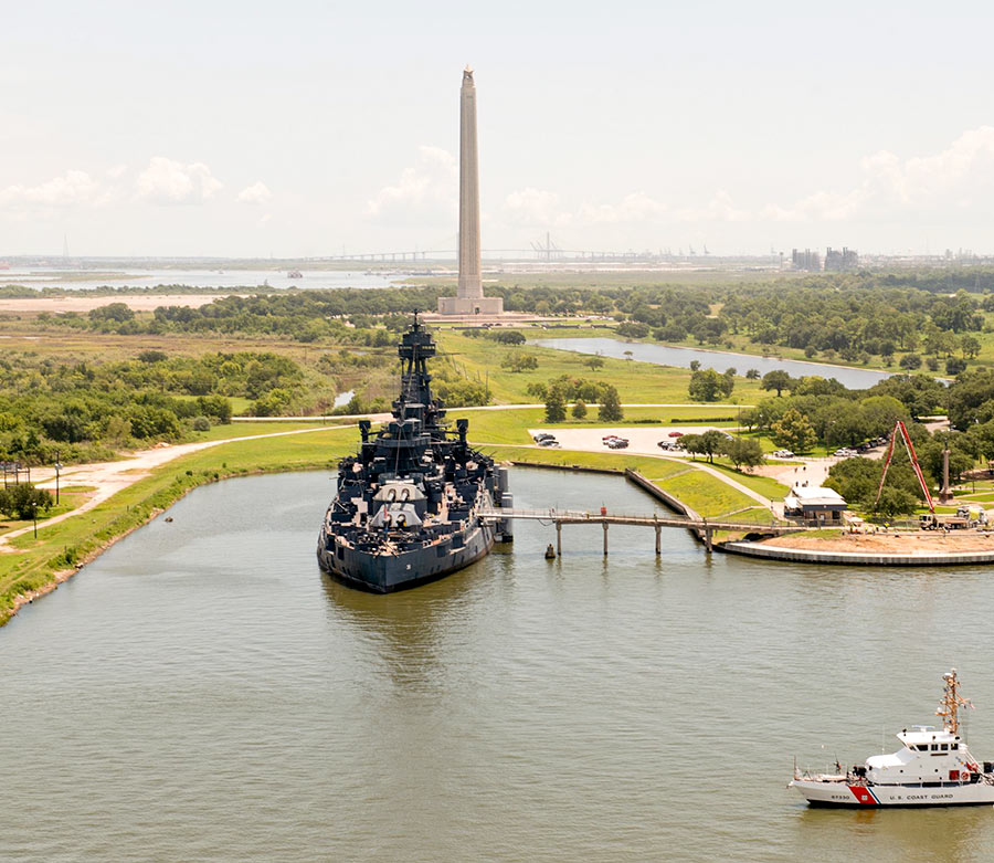
Along the Ship Channel
06/12/17 11:15am

HOUSTON’S PREMIER FLOATING TOURIST ATTRACTION SHUT DOWN AGAIN AFTER MORE LEAKS A 6-by-8-in. hole 15 inches below the water line discovered yesterday on the starboard side of the Battleship Texas caused the San Jacinto Battleground tourist attraction to tilt a “pretty serious” 6 degrees overnight, KPRC’s Cathy Hernandez reports this morning. The battleship — which was built long after the Battle of San Jacinto, but is a veteran of 2 world wars and a whole lot of 21st Century rust — has now been closed to the public until further notice. At last report, approximately 2,000 gallons of water per minute had been pumped out of the ship for more than 15 hours. Funds originally allocated to move the retired sea vessel to a dry berth were used instead to repair previous leaks. [Click2Houston; Texas Parks & Wildlife; previously on Swamplot] Photo: Coast Guard News [license]  

11/07/16 11:00am

WHAT’S SO SPECIAL ABOUT THE PASADENA REFINERY THAT RELEASED 3 MORE TONS OF AIR POLLUTION ON THURSDAY? Pasadena Refinery System plant at 111 Red Bluff Rd., Pasadena, TX 77506
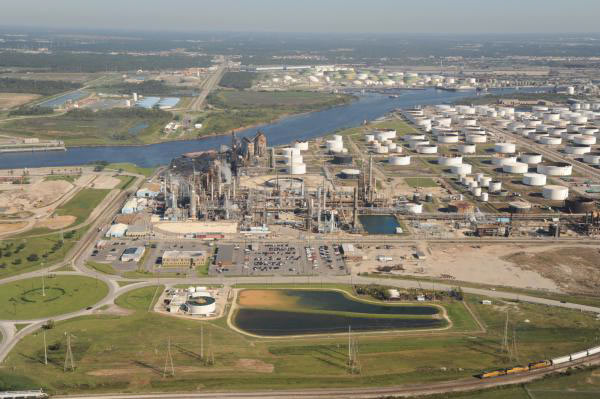
“We worry about this plant more than we worry about the others,” Air Alliance Houston director Adrian Shelley tells Dylan Baddour after last week’s release of a 6,000-pound cocktail of toxic air contaminants from the Pasadena Refinery System complex, south of Buffalo Bayou just east of the Washburn Tunnel. The release occurred in the wake of a 7-hour power outage at the Petrobras-owned refinery (which played a role in the massive Brazilian corruption scandal that came to light last year); Baddour says this is the 8th contaminant release the company has reported so far this year (and the 65th since 2005). Shelley notes that the plant has a reputation for “large particulate matter (soot) release events that you really don’t see at other Houston refineries,” including the 2 tons of soot released on Thursday with sulfur dioxide gas and other contaminants; Shelley also notes that one of the plant’s key federal permits expired last year, resulting in a $7000 fine from the TCEQ. [Houston Chronicle; previously on Swamplot] Photo of Pasadena Refinery Systems, Inc. plant at 111 Red Bluff Rd.: Center for Land Use Interpretation (license)

09/26/16 3:00pm

COMMENT OF THE DAY: THE PRICE OF SAVORING THAT MOUTHWATERING HOUSTON INDUSTRIAL FLAVOR Oyster wardens of TPWD
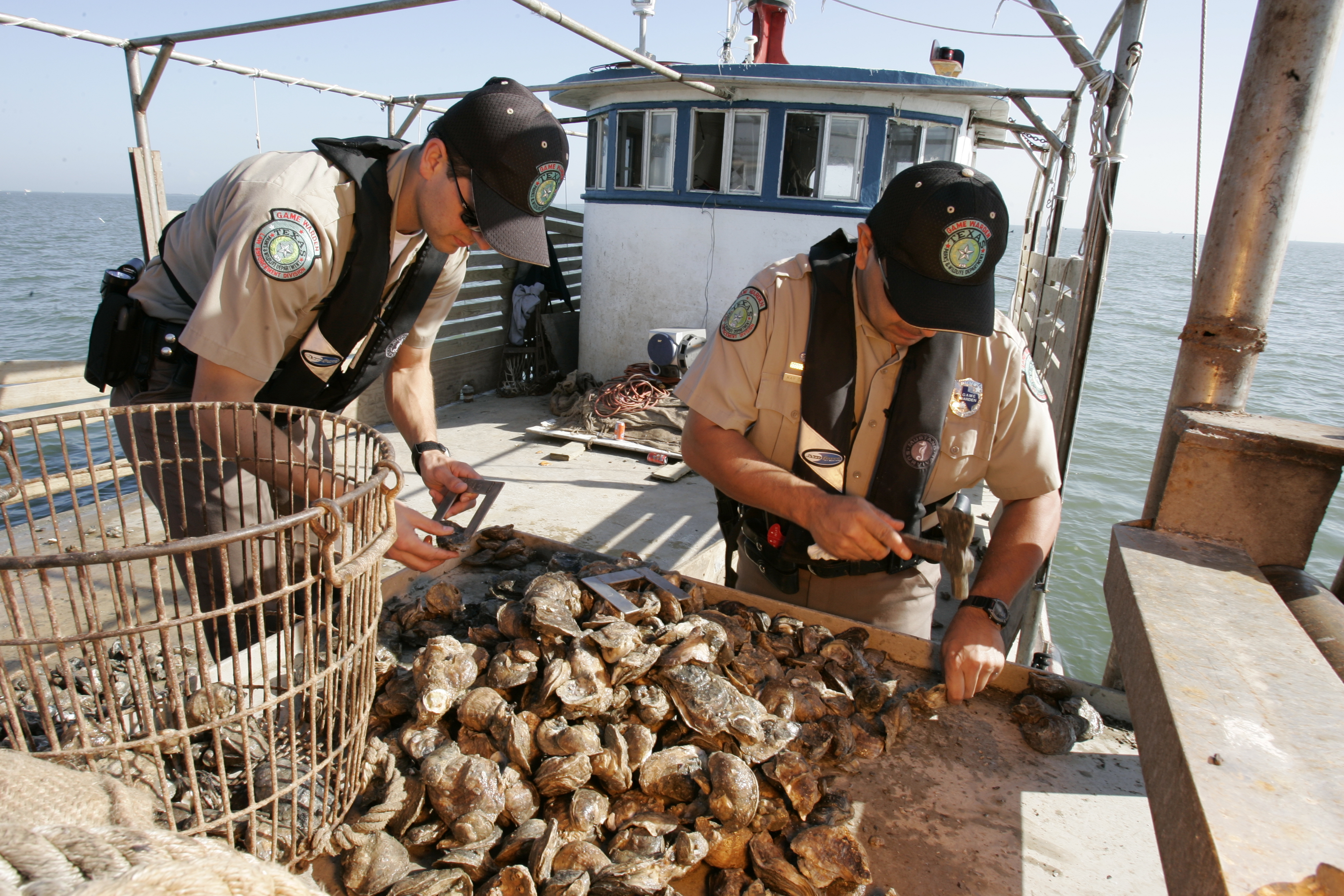
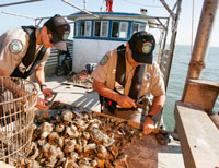
“I always found that Galveston Bay oysters had a slight metallic tinge to them (as compared to oysters from Matagorda or San Antonio Bays) — and actually, I quite like it. Perhaps it could be said that a true appreciation for Galveston Bay’s environs doesn’t come without some carcinogenicity. Oh well — so be it.” [The Niche, commenting on Oyster Tycoons Fight over Baybottom Territory as Reefs Recover from Flooding] Image of state game wardens examining oysters: TPWD

09/06/16 5:00pm

COMMENT OF THE DAY: KEEPING BUFFALO BAYOU IN ITS PLACE Buffalo Bayou at Barker Reservoir, Houston“Sounds nice — but that little part about the bayou being in the middle of the city, that’s why it can’t be left up to nature. . . . I understand the need to conserve and protect, but the Buffalo Bayou we know today is man-made. Ship Channel, Turning Basin, the resevoirs, Allen’s Landing, even the ill-fated Shepherd’s Dam all took a meandering stream and turned it into an industrial workhorse for Houston. Basically the ‘natural flow’ is impossible to get back; for that matter it never was something that the majority of Houstonians wanted. There are other bayous and creeks in the area that can take up the cause that don’t happen to be in one of the most expensive and sought-after flood plains in America. It is a noble battle but it was doomed to be one of beautification, not naturalization the moment the Allen Brothers decided to build a better New York City in Texas.” [SimplySid, commenting on Stop Trying To Fix Buffalo Bayou, Says Save Buffalo Bayou] Photo of Barker Dam outlet structure on Buffalo Bayou: Swamplot inbox

04/08/16 3:15pm

Fire at LyondellBassell Refinery, 12000 Lawndale St., Houston, 77017

News choppers milling around the LyondellBasell refinery at 12000 Lawndale St. this morning, just west of the 610 bridge over the Ship Channel, caught some shots of billowing black smoke and flames at the facility, which have since been put out. The company reports that heavy fuel oil and cleaning fluids burned after a Coker unit caught fire around 10AM for reasons yet unknown.  The Houston fire department suggested until about 11:15 that folks please stay indoors and try not to let in any fumes in nextdoor Manchester, as well as south and west as far as Park Place Blvd. and Broadway St.; students at nearby Chavez High, Deady Middle School, and Rucker Elementary were also included in the shelter-in-place fun.

After burning for about 2 hours, the fire was put out just before noon — not nearly as speedily as yesterday’s fire at the ExxonMobil refinery in Baytown, which started around 4:40PM and was out by just after 5. That fire’s cause is also unknown; no injuries were reported in either incident.

CONTINUE READING THIS STORY

Booming on the Ship Channel
03/06/15 2:30pm

COMMENT OF THE DAY: FOLLOW THE SMOG Map of Ozone Levels Over Houston, August 6, 2012“You do not escape smog in Houston by moving to the burbs. In the summer, Houston has a circular wind pattern that takes ship channel pollutants for a ride out to the suburbs. Go to the Houston Clean Air Network website and set the animation for Aug. 6, 2012. You will see a big area of ozone form over the ship channel that gets blown out to Pearland, then Sugar Land and spends the late afternoon in Cinco Ranch and just east of Katy before starting to drift back east. The worst of the smog slides south of the City and never really gets north of I-10 inside the loop. Ship channel industries account for about 2/3rds of the smog. The rest is motor vehicle emissions. Ship channel industries have made significant progress in reducing and controlling emissions. But more sprawl and more traffic threaten to offset the progress made on the ship channel. Thus, the smog issue is a very real consequence of sprawl that is not escaped by sprawl either.” [Old School, commenting on Holding Back on That Downtown Hotel Push; The Beer Garden, Greenhouse, and Food Court Growing in Prohibition’s Basement] Image: Houston Clean Air Network

12/19/14 3:30pm

COMMENT OF THE DAY: WHY IS ANYONE LIVING THAT CLOSE TO A REFINERY? Refined Homes Near Refinery“Tax policy should probably discourage residential habitation in neighborhoods near the Houston Ship Channel and encourage people to move away from them. As such, giving existing residents or residential property owners a tax cut in order to reward them for residing there or maintaining and leasing housing to other people would be extraordinarily counterproductive and stupid. Manchester in particular is a neighborhood where the City or State government should seriously consider its options with respect to eminent domain. There’s nothing quite like it anywhere else in the region. Even the furthest north residential bits and pieces of Pasadena are better isolated from refinery activities and more integrated into their city than is Manchester.” [TheNiche, commenting on Baytown Buc-ee’s Is Here; Goodbye Mission Burrito, Hello Ãœberrito Mexican Grill] Illustration: Lulu

11/21/14 4:00pm

A LOFTIER VIEW OF THE HOUSTON SHIP CHANNEL Can’t stop celebrating the Houston Ship Channel’s recent centennial, but unable to make it to that exhibit downtown? Do industrially majestic helicopter shots of mighty tankers and container ships hewing their way through brown waters to and from the deep blue sea, between banks lined with tank farms and smoke-belching chemical stacks, and shorelines spanned at intervals by such engineering marvels as the Fred Hartman Bridge leave you weak in the knees? Then check out Houston Ship Channel: Deep Water Centennial, the 56-minute film produced by the Texas Foundation for the Arts. It ran recently on local public teevee, but it’s now available on YouTube (and embedded above). It features lots of stentorian narration of “commerce porn” factoids and stats (“The most foreign ship calls! . . . It’s longer than the Panama Canal! . . . Such huge gross tonnage!”) recited above beds of stirring, vaguely martial music. If you aren’t ready to commit to the full 57 minutes, you can get a sampling via the separately posted trailer. Video: Houston Public Media

11/21/14 2:15pm

THE SHIP CHANNEL’S FOLK HISTORY ON VIEW Vest-photo-boatman-300 Houston Arts Alliance’s Stories of a Workforce: Celebrating the Centennial of the Houston Ship Channel, an exhibit running through January in the Houston Public Library’s Julia Ideson building, focuses on the Houston Ship Channel’s second 50 years, a half-century that saw the port utterly transformed by the advent of the containerization of cargo.  The centerpiece of the exhibit is a John Biggers mural of African-American dockers hoisting cargo, and the room is dotted with the photographs and timelapse films of working Channel pilot and photographer Lou Vest. Newspaper clippings shine a light on the Channel’s occasional outbreaks of labor strife,while in an alcove across the hall, viewers can take in a collage of portraits of typical houses in harborside neighborhoods such as Fifth Ward, Magnolia Park, Clinton Park, and Denver Harbor that many dock workers have called home for generations.  Via overhead speech domes, you hear the pilots, stevedores, and boatmen tell their own stories in their own words. The exhibit is less a standard, top-down institutional retelling of the Ship Channel story than it is a Studs Terkelesque folk history. [Houston Arts Alliance] Photo: Lou Vest.

10/30/14 1:15pm

Finca Tres Robles Farm, 257 N. Greenwood St., East End, Houston

Two brothers who have opened a new agricultural venture in Houston’s East End are billing it as Houston’s “first private farm inside the 610 Loop.” Amid the gritty industrial wilds of N. Greenwood St. between Navigation and Canal — just a few blocks south of Buffalo Bayou’s Turkey Bend —Finca Tres Robles (spelled out and illustrated helpfully in the photo above) now sprouts on land owned by Electro-Coatings, a plating company. Other less bucolic neighbors, such as Baker Oil Tools and the US Zinc Houston Dust Plant, lurk nearby.

Until its 1996 purchase by Electro-Coatings (along with a warehouse owned by Sara Lee), the 1.2-acre plot now occupied by the farm served as a TxDOT service site. It lay vacant for the last 18 years. Beginning 6 or 7 months ago, the new proprietors jackhammered away the vestigial asphalt; they’ve since composted the lot and commenced agricultural operations.

Here’s the plan:

CONTINUE READING THIS STORY

Finca Tres Robles
10/07/13 11:00am

BUILDING A MONUMENT TO GATED FLOOD CONTROL AND TOURISM Protecting the Ship Channel during an Ike-like (or worse) storm surge has led some to propose a big dike, others a big gate. But UH professor of urban planning Tom Colbert doesn’t see why we couldn’t trouble ourselves to make such protection a real sight to see too: “Colbert likes the idea of . . . connecting the Centennial Gate and its levees to the proposed Lone Star National Recreation Area, undeveloped land that would both attract ecotourists and slow floodwaters,” reports the Houston Chronicle’s Lisa Gray: “I remembered one drawing I’d seen in [Colbert’s] PowerPoint show: Happy tourists, paddling kayaks past the Hartman Bridge, on one of the byways out of the big ships’ path, waterbirds and wetlands all around. Colbert motioned southeast, toward the Ship Channel’s mouth, toward Barbours Cut, the other possible location for the floodgate. There, he said, the levees would cross the channel’s water, connecting the Ship Channel’s artificial islands — made from dirt dredged from the channel — to the shore. Enough room could be left on top of the levee for a hiking path or even for car access; for the first time, it would be possible for people to get to the Atkinson Island Wildlife Management Area — a bird mecca on manmade land — without a boat. You could even, he notes, build a tourist destination atop one of those islands: He proposes a monument to Houston, the gateway to North America, the place where nature meets industry. In some drawings, just to give people the idea, he plunks the Statue of Liberty atop a Ship Channel island.” [Houston Chronicle ($); previously on Swamplot] Photo of Fred Hartman Bridge: Chuck Wilkson

09/13/13 10:00am

BATTLESHIP TEXAS BACK IN ACTION The leaky ol’ boat is taking on a new role in national security: This week, it has become the training ground for a 6-ft.-long drug-sniffing robot tuna. A group out of Boston has designed the BIOSwimmer, described in the Sugar Land Sun as a “highly maneuverable, unmanned underwater vehicle that is equipped with a sophisticated suite of sensors.” Already having served dutifully in 2 world wars, the veteran ship is now helping to protect our ports:The test team is planting packages of mock contraband of varying sizes in tight, hard-to-reach spaces on the battleship’s hull and putting the BIOSwimmer through the paces to see if it can successfully detect them.” [Sugar Land Sun; previously on Swamplot] Photo: Candace Garcia

05/30/13 4:35pm

HOW HOUSTON’S AIR GOT BETTER During the past decade, Houston’s notoriously polluted air has become — well, if not quite good, then not quite as bad, says NPR’s Richard Harris. (Pay no attention to what that ozone app may or may not tell you.) How? Well, it seems that pollution regulators in the early aughts had been worrying about all the wrong gases: “They were going all-in against [only] one of the pollutants that create smog, while downplaying the role of other emissions from the petrochemical plants,” reports Harris. “Barges carting chemicals up and down the [Ship Channel] were leaking. . . . And some types of storage tanks were leaking as well. . . . It turns out that routine day-to-day emissions were not the biggest problem.” Since then, regulations targeting those chemicals, like ethylene — as well as the use of infrared cameras that can spot them — appear to have made a difference: Port of Houston Authority employee Dana Blume tells Harris: “I can look out of my office window now and almost every single day see downtown.” [NPR; previously on Swamplot] Photo: Flickr user stmu_mike

04/18/13 3:40pm

ART GUYS WORKING WITH SHIP CHANNEL IN NEXT ‘EVENT’ At the site shown here in Pasadena near the old Paper Mill and Washburn Tunnel, where General Antonio López de Santa Anna is said to have been captured during that historically succinct Battle of San Jacinto, the Art Guys are planning their next performance: They’ve announced they’ll crack out their batons and “conduct the sounds of the Houston Ship Channel.” (Not sure what that could look like? Go see it for yourself.) Jack Massing and Michael Galbreth, the helmsmen of “12 Events,” a yearlong series of monthly head-scratchers that commemorate their 30 years of Houston mischief, have so far in 2013 shrugged off their divorce from the Menil, signed their names for 8 hours at the Julia Ideson Library on National Handwriting Day, and walked all 29.6 miles of Little York Rd., the longest in Houston. Next up, once they’ve conducted the Ship Channel waters? The Art Guys unwind a spool of thread, and then — wait for it — wind it back up again. [The Art Guys; Culturemap; previously on Swamplot] Photo: JimmyEv via Waymarking