NEWLY-PROPOSED STATEWIDE FLOODING FUND WOULD BE SPRINKLED WITH $1.2B FROM TEXAS’S RAINY DAY RESERVES  State Senator Charles Perry filed a trio of bills on Tuesday that aim to create a state-level plan for flood mitigation, to be funded by $1.2 billion drawn from Texas’s $11 billion rainy day fund, reports the Texas Tribune’s Carlos Anchondo. If the House and Senate agree to tap the state’s nest egg by a two-thirds vote — a level of consensus that’s proven difficult to reach in the past, notes Anchondo — the legislation would then divide Texas into regional flood planning groups that trace the outlines not of municipalities, but rather of the state’s watersheds in order to “ensure one community’s plans do not inadvertently negatively impact a neighboring community,” says Perry. (The Texas Water Development Board would oversee the mapping and could choose to deviate from watershed boundaries in exceptional cases.) Within every watershed group, a representative from each county would receive a single vote, which they’d use to hash out a regional flood plan including both physical projects (such as reservoir improvements) and strategies (such as strengthening building codes). Taking a look at each region’s plan, the state would then compile a ranked list of flood mitigation approaches across Texas and kick in portions of the $1.2 billion for them accordingly starting sometime in 2024 . . . at the earliest. [Texas Tribune; press release] Photo of the Texas Senate chamber: Arthur LeBon [license]
Tag: Flood Control
ARMY CORPS’ FIRST PUBLIC IKE DIKE DISCUSSION IS TOMORROW 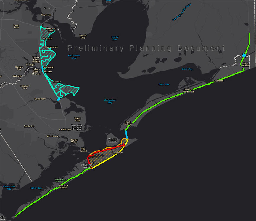 Tomorrow, the Army Corps will hold a public meeting in Port Lavaca about the Ike Dike it proposed last month. The meeting — the first of 6 planned between now and April — will give the agency an in-person opportunity to defend the modeling system underlying its $30 billion recommendations, which took some heat earlier this month from Rice U. scientists who claimed it didn’t take into account all those 100-year events that keep happening every few years. Since then, the Corps has told the Chronicle’s Nick Powell that isn’t true, adding that numerous key tweaks have brought the system up to date from FEMA’s earlier model, used in flood insurance mapping projects. The public comment period for the proposal remains open until mid-January. [Houston Chronicle ($); previously on Swamplot]
COASTAL DEFENSE EXPERTS SAY IKE DIKE WON’T BE ENOUGH WITHOUT A BACKUP WALL  With the public comment period underway on the Ike Dike proposal the Army Corps issued last month, Rice University scientist Jim Blackburn weighs in on the project: “We think that there is too much remaining surge exposure,” he tells the Chronicle‘s Nick Powell on behalf of the research team he heads. Why’s that? “The storms that are being analyzed by the Corps are, in my opinion, too small,†Blackburn says. “They’re just not making landfall at the worst locations, with the type of wind fields and characteristics we’re seeing.” Had the Corps’ methodology accounted for a worst-case storm, says Blackburn, its analysts would’ve seen that the projects they proposed — 70 miles worth of walls and gates between High Island and San Luis Pass — are inadequate without a key addition: an upstream gate that’d run across the middle of Galveston Bay, further shielding the Ship Channel and its adjacencies from floodwaters. “We are going to argue that to any governmental entity that is interested,” says Blackburn, adding, “I think we need options. If all of our eggs are in a $30 billion federal appropriation, that just sounds too risky to me.†One key selling point for the gate: It could be built in about half the time the other proposals would take and at a fraction of their cost, says Blackburn, between $3 billion to $5 billion. [Houston Chronicle ($); previously on Swamplot] Map of Ike Dike proposal: U.S. Army Corps of Engineers
SNEAKING A PEEK AT THE BIG WALLS, BIG GATES ARMY CORPS COULD PROPOSE FOR THE COAST LATER THIS MONTH  On October 26, the agency will single out one of the 4 big proposals it’s been pondering for the Texas coast as the chosen one, reports the Texas Tribune’s Kiah Collier. One of them “calls for the construction of a 17-foot-high levee along the entirety of Galveston Island,” as well as Bolivar Peninsula. Ring any bells? It’s the so-called Ike Dike (also known as the “coastal spine”) that A&M scientists dreamed up about a decade ago in response to the disaster and hypothetically-even-worse disaster that could’ve occurred if Ike had struck 30 miles further west. Another defense against that doomsday scenario that could make it into the proposal: a giant gate structure adapted from Rice’s Jim Blackburn and Philip Bedient’s 2011 idea for a mechanism that’d close before storms to block surge. (They wanted to put it just upstream from the Fred Hartman Bridge; the Corps has number of different spots in mind.) All the plans in the running include a so-called ring levee around Galveston’s bay side to protect it from reverse storm surge, a helping of smaller levees and gates, upgrades to existing flood control structures, and ecosystem restoration projects geared toward creating natural floodwater-fighting barriers. [Texas Tribune; previously on Swamplot] Map indicating proposed Alternative A plan: U.S. Army Corps of Engineers
NEARLY 100 MEYERLAND HOUSES WILL SOON BE UP OFF THE GROUND 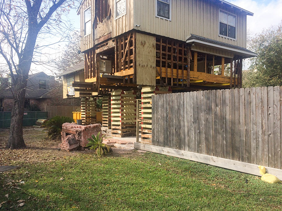 Forty homes total have now been elevated in Meyerland and 57 are currently on the way up, reports Nancy Sarnoff. Their boosters are seeking the same degree of flood protection enjoyed by the 29 percent of Meyerland homeowners whose houses have never flooded in the past. A few elevations have been paid for by the City of Houston; others were self-funded. [Houston Chronicle ($); previously on Swamplot] Photo of 4718 N. Braeswood Blvd.: Christine Gerbode
WHAT’S ON THE TABLE IN HARRIS COUNTY’S FLOOD BOND MEGA VOTE, STARTING TOMORROW 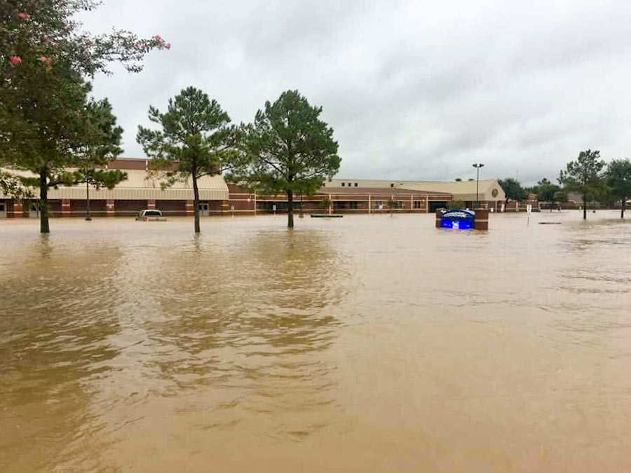 Included in the flood control bond package county residents are about to start voting on: $1.2 billion for channel improvements, $401 million for detention basins, $242 million for floodplain land purchases, $184 million (coupled with $500 million in outside funding) for 3,600 home buyouts, $12.5 million for new floodplain mapping, and $1.25 million for a better flood warning system — according to totals the Chronicle’s Zach Despart summed up from the master list of 237 individual projects. Not included: money for a third reservoir, although $750,000 is on the table to help the Army Corps study the possibility of one. Taken together, the $2.5 billion proposal‘s price tag is more than 20 times the Harris County Flood Control District’s annual budget of $120 million. Voting wraps up on Saturday, August 25, the anniversary of Harvey’s arrival in Houston. [Houston Chronicle ($); full list (PDF); previously on Swamplot] Photo of flooding at Creech Elementary School, 4242 S. Mason Rd., Katy:: Breta Gatlin
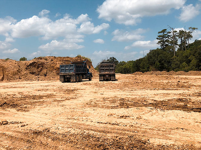
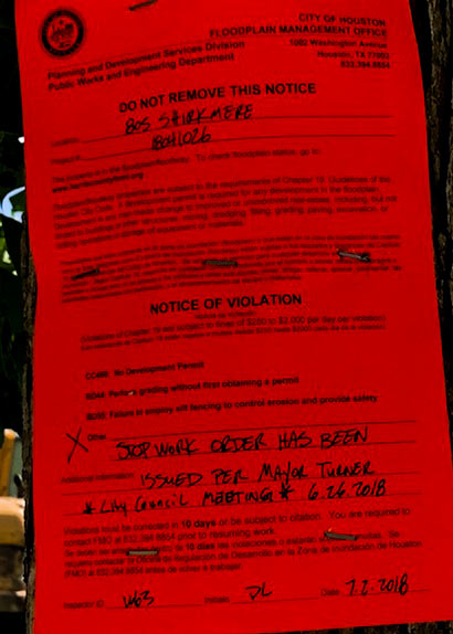
At last week’s city council meeting, Mayor Turner told residents that the Stanley Park subdivision now on the rise in the 100-year floodplain south of Timbergrove Manor “is currently on hold. I know Harris County Flood Control has put a hold on it. We have also put a hold on it to take a look at it.” But as of Monday morning, site work was still continuing on the 12-acre parcel — according to StopStanleyPark, an organization nearby residents set up to oppose the project — until the red tag pictured above was issued for it in the afternoon.
A pair of dump trucks, along with an excavator were the latest visitors to the job site at the end of Shirkmere Dr.:
COMMENT OF THE DAY: THE SLEEPY STREETS HARRIS COUNTY FLOOD BUYOUTS LEFT BEHIND  There is a community close to 290 and Windfern, on Cole Creek Dr. and another near Fairbanks and Hollister on Woodland West. Deep in the flood neighborhoods that were bought back by Harris County Flood [Control District] a while ago. All of the roads, utilities and everything are there. Just no homes or homeowners. Made a great place to take a post-lunch car nap when I worked close by. [bocepus, commenting on The Latest Wave of Harris County Home Buyouts, Mapped] Illustration: Lulu
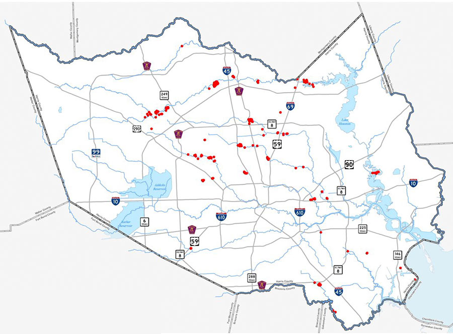
Now that a second, $51 million round of FEMA funding for home buyouts has come through, here’s the map of where the latest government snatch-ups are planned, 294 total. As indicated by the red dots above, they’re all outside the Loop — with a good portion grouped in 3 distinct clusters along Cypress Creek (which drowned out previous flooding records along nearly its entire length during Harvey). Other hotspots include several along White Oak Bayou, as well as a Greens-Bayou-adjacent bunch off Beltway 8 just north of Aldine and a San Jacinto River-side group south of Hwy. 90, near Highlands.
The money Harris County Flood Control District expects to receive for these purchases supplements an earlier $25.6 million FEMA committed to it on June 4. That previous check (along with an $8.6 million match the Harris County Commissioners okayed in order to get it) will be spent on about 169 buyouts, mapped out below:
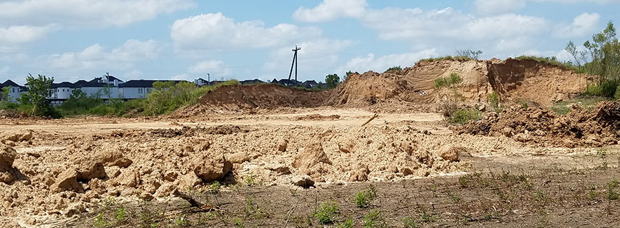
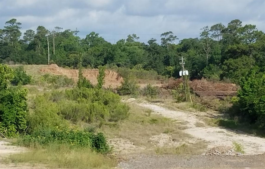
Hillocks of dirt dot the landscape west of T.C. Jester, adjacent to the train tracks near the end of Shirkmere Dr. where Lovett Homes is now elevating some of the 77 lots that’ll make up its new Stanley Park subdivision. Since receiving a commercial fill permit from the city in April, the developer has stacked soil across the site — which lies entirely within White Oak Bayou’s 100-year floodplain and has never before been built on.
Also included in that flood-designated realm: the Timbergrove Manor neighborhood just north of the development. Its southernmost street, Queenswood Ln., had it up to here during Harvey:
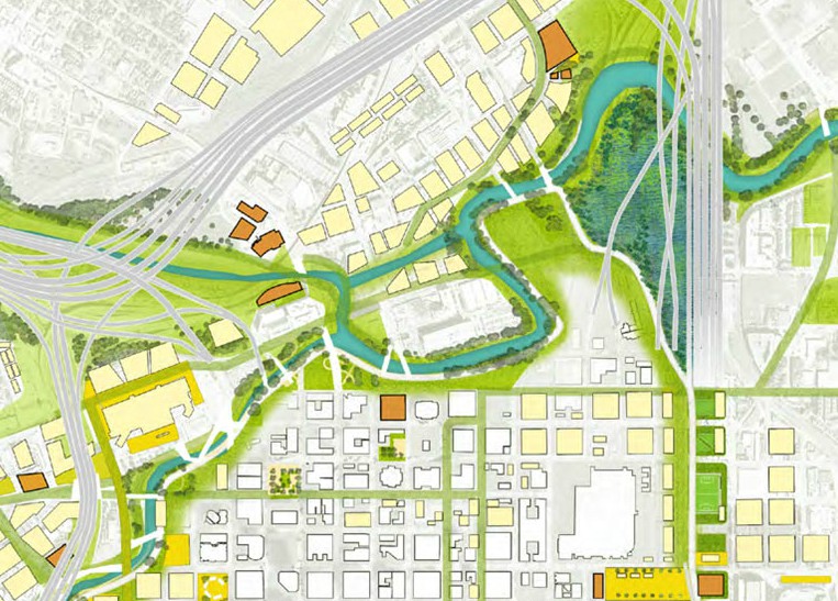
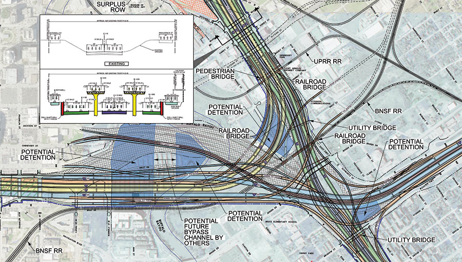
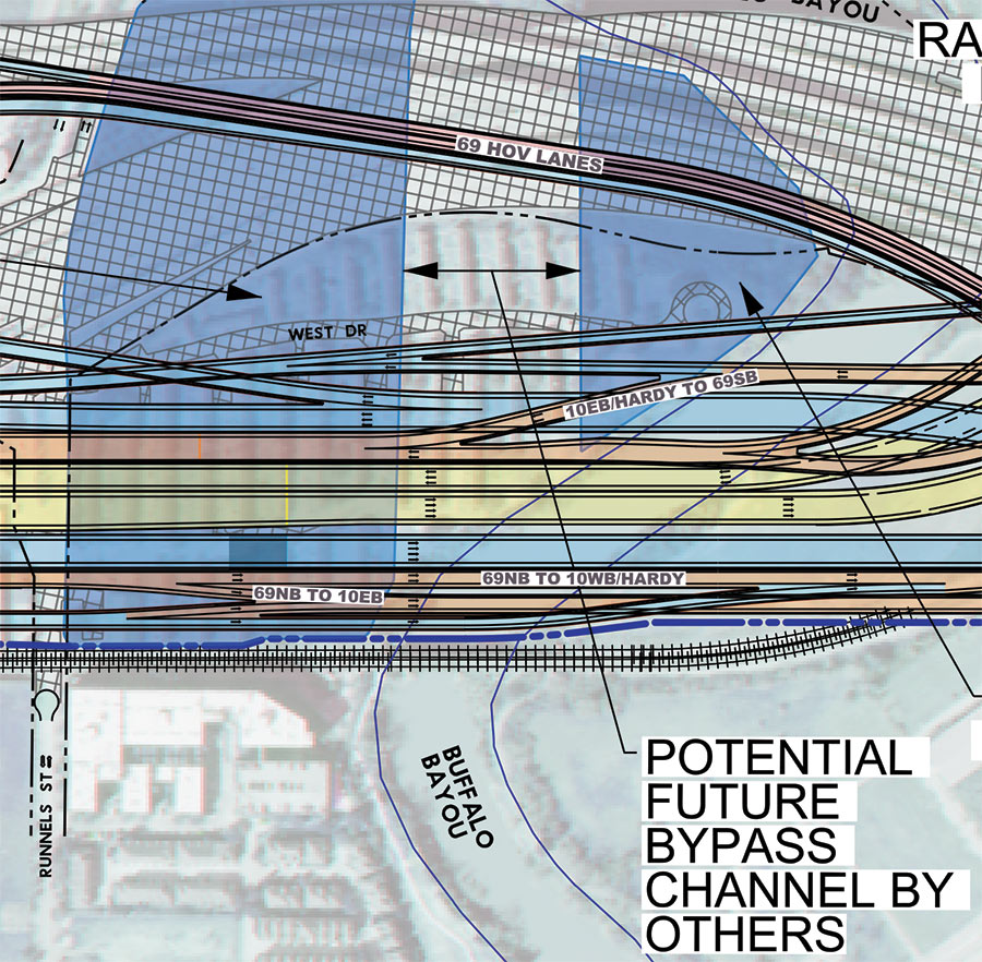
Remember that North Canal that showed up in Plan Downtown’s maps and drawing last year and included a island in Buffalo Bayou? Well, TxDOT’s latest schematics for its planned I-45 reroute include a bypass and island as well — but in an entirely different location. The highway agency’s map above — with west facing up — indicates a new waterway draining into Buffalo Bayou right underneath the section of I-45 it plans to build in place of a portion of the Houston Housing Authority’s Clayton Homes neighborhood. How the canal gets there is obscured, but a straight course northwest appears to shoot the gap between 2 planned detention ponds and cross under the existing section of 59 (shaded gray), before linking up with the bayou again east of Elysian St. Marooned on TxDOT’s version of the make-believe, bayou-banked island the canal would create: a few of the houses in Clayton Homes.
As TxDOT’s caption makes clear, it’d be up to someone else to actually build the waterway. Doing so wouldn’t preclude the previously proposed North Canal from being dug further upstream. Plan Downtown’s less technical map at top shows that waterway beginning at White Oak Bayou and emptying into a bend of Buffalo Bayou just west of Elysian. In doing so, its course creates an exclusive new landmass home to the Harris County jail.
- Conceptual Roadway Layouts and Typical Sections [TxDOT]
- Previously on Swamplot: Funding for Downtown Houston’s New Island; The North Canal, a New Downtown Island, and Other Secret Plans for Downtown Houston’s Future; Latest Mindboggling TxDOT Video Shows Off Rainbow Tangles of Spaghetti-tastic Downtown Freeway Redo Plans in Simulated Drone View; Big I-45 Downtown Rerouting, Grand Parkway Expansion Get Go-Aheads; TxDOT To Pierce Elevated: Your Years Are Numbered, Probably; TxDOT’s Plans for Freeway Expansion Around and Below the Newly Protected Cheek-Neal Coffee Building; Wacky TxDOT I-45 Redo Renderings Now Available in Mind-Boggling Video Format; The 5 Wackiest Images from TxDOT’s Plans To Reroute I-45 and Abandon the Pierce Elevated
Road map: TxDOT. Downtown map: Plan Downtown
COMMENT OF THE DAY: COULD A THIRD RESERVOIR, UP NORTH, HOLD WATER? 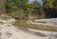 “Make a reservoir or lake north of the city, just west of Humble at the confluence of Spring Creek and Cypress Creek, as well as the San Jacinto River just a bit to the east. This land is still undeveloped. These three major tributaries coming together in short order accentuates the flooding issues. If the water has nowhere to go it’s going to cause flooding. While a reservoir in west Harris County will hold that water back from surging downstream, it does absolutely nothing for the rainfall that falls on the hundreds of square miles of land in the Spring Creek, downstream Cypress Creek and San Jacinto River watersheds. The main intent of the proposed third dam is to keep the water from overflowing into Barker and Addicks. Creating a lake here could serve not only flood control issues, but also provide for another source of drinking water.” [Thomas, commenting on Abbott Signs Off on Harris County’s Harvey Anniversary Flood Bond Vote] Photo of the confluence of Spring and Willow Creeks: Northampton MUD
ABBOTT SIGNS OFF ON HARRIS COUNTY’S HARVEY ANNIVERSARY FLOOD BOND VOTE 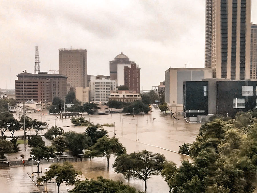 In a letter to the Commissioners Court yesterday, Gov. Abbott approved Harris County’s request to hold an August 25 bond election that would pay for a long, not-yet-finalized lineup of flood control projects. On the short list so far: “the buy-out of all of the county’s high-priority areas at highest-risk of flooding, approximately 5,500 properties,” Judge Emmett tells the Chronicle’s Mihir Zaveri — as well as the financing of “some portions a much-discussed third reservoir northwest of the city,” and “numerous bayou and creek widening projects.” Also included: a handful of detention basins and drainage improvements to waterways in both Houston and the MUDs of unincorporated Harris County, according to the flood control district. The district now has about 4 months to compile the list, during which time Harris County “plans to launch a public outreach campaign to seek input on what to include in the bond package, as well as drum up support for the measure.” [Houston Chronicle ($), previously on Swamplot] Photo of Sesquicentennial Park and Franklin St. during Harvey: Kelsie H. Dos Santos
HARRIS COUNTY OPTS TO SCHEDULE FLOOD BOND VOTE FOR HARVEY’S ANNIVERSARY  The Harris County Commissioners Court voted this morning to move forward with scheduling a multi-billion-dollar flood control bond referendum — to fund property buyouts, bayou widening, and other mitigation efforts — for August 25. “Why August 25?†Judge Ed Emmett asked the room — which included the Chronicle’s Mihir Zaveri — “It’s the 1-year anniversary of Harvey. It’s got a certain sex appeal to it.†Commissioner Rodney Ellis at first opposed the commemorative date, fearing voter turnout could be weak during the summer. “If it is one shot that we have, I just want to make sure we get it right,†he said. (If the referendum fails, the earliest the court could hold another one would be in May 2019.) He argued instead for a date during November’s mid-term elections but changed his mind “for the sake of unity†after an appeal from fellow Commissioner Steve Radack — putting a unanimous finishing touch on the back-and-forth. What’s now needed in order to get it on the calendar? Governor Greg Abbott’s sign-off, followed by a vote from Harris County making the date official. [Houston Chronicle; more] Photo of Buffalo Bayou flooded by Hurricane Harvey: Adam Brackman
HOW THEY’RE AVOIDING FLOODING FAR UPSTREAM FROM DOWNTOWN HOUSTON 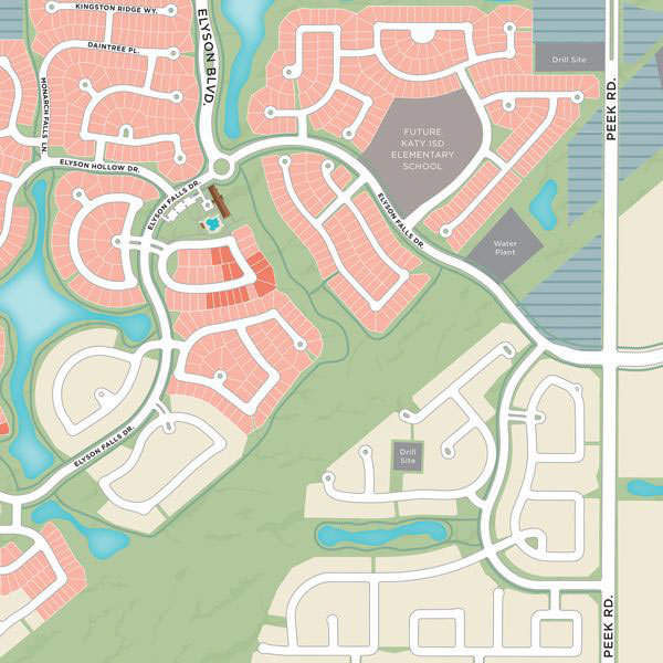 How was developer Newland Communities able to lift the first cohort of 6,200Â planned new homes out of the 100-year floodplain in Elyson, its Katy Prairie development just west of the Grand Pkwy. at FM 529? Easy: by raising the lots 1 ft. with dirt taken from other areas of the site. (An additional 12 to 15 in. of elevation came from the slab foundations on which the houses rest.) The fill allowed the company to obtain letters of map revision for more than 300 home lots in 2016 — and “to tell buyers, accurately, that their homes were not in the 100-year flood plain.” The results: “The company reported in September that Harvey had flooded streets in the development, but no water entered any of the 94 houses occupied at that time. The risk of flooding could increase, however, as more structures are built on the property.” [Houston Chronicle] Partial map of Elyson: Newland Communities

