
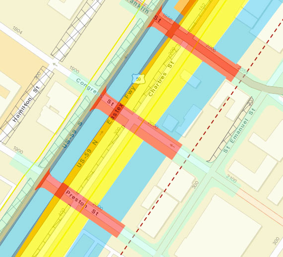
A dotted line runs right along the inside edge of the Cheek-Neal Coffee Company’s former roasting plant at 2017 Preston St. at the corner with St. Emanuel St., which was declared a protected city landmark today after starts to the building’s redevelopment by new owners last year. The line marks the proposed right-of-way for TxDOT’s plans to reroute I-45 alongside 59 and send the Pierce Elevated out to pasture, as shown in update documents released in September. The 1917 building shows up as a beige box at the corner of Preston and St. Emanuel in the above capture from the project’s interactive online map system, and the seafoam green highlighting to the left indicates the newly planned frontage roads that would run to the west of it.
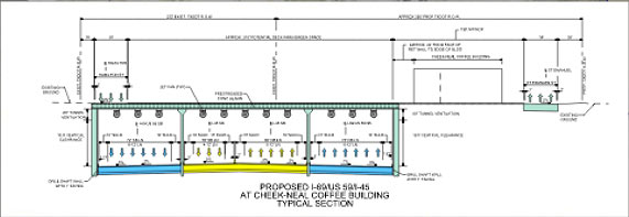
But the Cheek-Neal building itself actually doesn’t appear to be on the chopping block. The blue highlighting indicating the future path of freeway lanes skirt the western edge of the structure (though they appear to engulf the Loaves and Fishes soup kitchen across Congress St. to the north). Moreover, a cross-section through the I-45-59 bundle specifically shows the building in place, with the frontage road to the east and the freeways tucked out of sight below ground level:
***
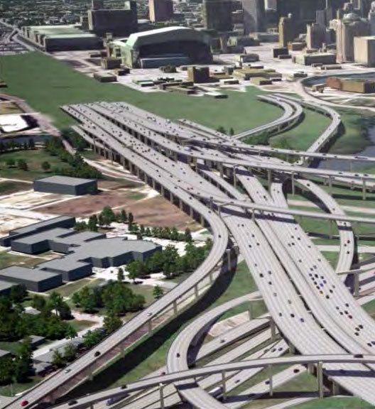
The September updates also include a rendering of the freeway’s many lanes disappearing into the earth beneath a swath of hypothetical greenspace behind Minute Maid Park and the George R. Brown Convention Center — greenspace which, the planning documents repeatedly emphasize, is conceptual only and would only be possible through separate funding and development:
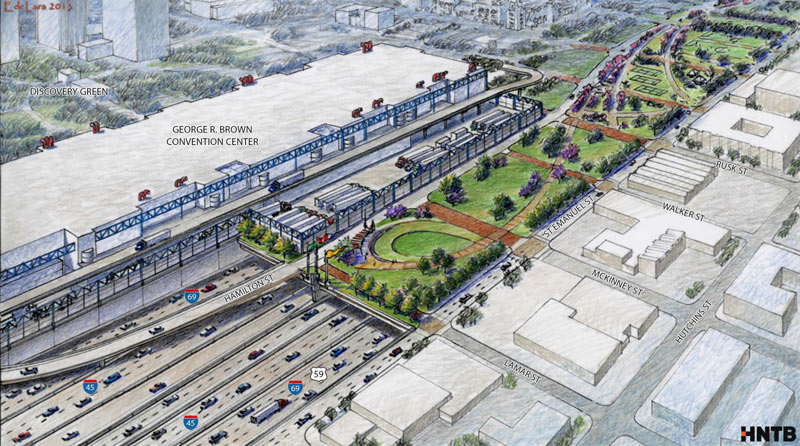
Here’s another sketch of what that greenspace could look like, should it come to be:
- Revised Project Overview Briefing Packet (Sept. 2015) [North Highway Improvement Project]
- Previously on Swamplot: Coffee Coming Back to Long-Vacant Coffee Plant Next to East Downtown Soup Kitchen; The 5 Wackiest Images from TxDOT’s Plans To Reroute I-45 and Abandon the Pierce Elevated
Images: TXDoT (maps), HNTB (renderings of green space)
If Boston can do a big dig that ran many times over budget and killed a poor soul when part or the tunnel ceiling caved in, the so can we!
“Yea, though I drive through the valley of the shadow of George R. Brown, I will fear no congestion, for I am the congestion.”
Is everyone a part of this project getting a kickback or have tons of land investments that will payout once this is done because all these plans are terrible. This has all the epic failings of Boston’s big dig written all over it. And didn’t we just read about how the I-10 expansion made things worse? What normal people want this and how does this make life easier?
I was for this reroute plan early on initially but as time has gone by I’ve grown against it. This massive freeway is going to ruin an up and coming scene happening currently in EaDo all for the sake of meshing Midtown/Downtown. The best alternative is to tunnel the Pierce underneath its current route. It’s the least destructive and will make all parties happiest IMO. And don’t give me this crap excuse that nothing can be underground here because of floods. If everything is supposably so “big” here in Texas, then please think bigger when it comes to this project.
What is the point of this? How does this help the people who commute from the suburbs? They are going to demolish two freeways, build a trench, cap it, and give us a few more lanes? Forgive me for believing that “improving” transportation means helping MORE people get in and out of the city more quickly.
In Houston there is only one solution to all congestion problems. Freeways can’t be improved without completely rebuilding them. Of course! It just feels corrupt somehow.
I refuse to be in a long freeway tunnel so the freeway on the side of the convention center under a park, but not underground or in a tunnel is better.
There are multiple simple practical directly affect how you live benefits here.
For the urbanists(and the other people thinking this hurts eado)
• Eado also gets reconnected, not just midtown, assuming the park actually happens, and the mental barrier of a raised highway between the neighborhoods is no more
• Parks always benefit neighborhoods, and it will help make the area more attractive for more redevelopment
For the car loving suburbanites
• 45 has to be completely redone some how(before it falls down), this plan gives us the ability to redo the highway in a different location without killing the traffic for over a decade as they tear down the existing pierce elevated and redo it while you are supposed to be using it(read as increased speed for you during construction)
• On the other side of downtown, the exit ramps into downtown become their own long piece of highway getting the exiting traffic out of the way for the people staying on 45 and 10 coming from the north and west(read as increased speed for you on going)
I understand everyone hates change but we always seem to be under the assumption that the way it is today is the best and only way for it to be. We have to take into account the benefits for every part of the city.
@Eddie this construction is at least five years in the future. Who knows what the state of EaDo will be at that point? Regardless, this will only take out half a block where most of the development is a full block over… and already near a freeway. Meanwhile, the removal of the 59 elevated will help mesh EaDo with downtown as well, not just Midtown.
.
All the comparisons to the Big Dig are unfounded. They’re not using new, state-of-the-art construction and tunneling techniques here, they’re going to be applying tried-and-true techniques, used most recently on the 635 LBJ reconstruction in Dallas. Cut-and-cover is a 150-year-old technology.
.
This isn’t just about the Pierce. The entire Downtown loop needs to be redone, and doing it piecemeal means design compromises and extended pain. A 5-7 year construction process to get all of this done is easily the least painful way of doing this, and the improvements to the urban environment only serve to make it better.
The I-10 expansion didn’t make things worse, they just didn’t make things much better, but there’s a big difference in those two items. Without the I10 expansion you would have seen an absolutely horrendous state of affairs over there. This goes back to that recent report where they were saying that we need to be spending billions of dollars on highway stuff just to keep up. Forward planning and whatnot is really important.
The section of park abutting the GRB Convention Center loading docks seems like a silly idea. I don’t know who would ever use that space.
The East End will never be able to seamlessly integrate with downtown as long as the Toyota Center, GRB, and Minute Maid Park are there. What’s the point in having Walker, McKinney, and Lamar go over 59 or through the proposed park only to have them dead end into the GRB?
Houston is paying the piper for the refusal 15-20 years ago of Mayor Lanier, Mayor Brown, and the entire METRO board to not consider building heavy, commuter rail into the suburbs. Instead, we did unsegregated street trams that don’t do much to lesson congestion or speed up transit times. So now we have TXDot stepping in and their solution is ever more concrete.
This project reminds me a little of I-5 through central Seattle, with a cut and cover tunnel and park over top. Didn’t Dallas do something similar with Woodall Rodgers through their museum district?
Let’s all ignore that this highway plows right through Clayton Homes! A city housing property home to several hundred minority Houstonians! But watch their voices go unheard!
We do need capacity expansion. The freeway radials were designed to feed downtown, so there’s not enough room for reverse and crosstown commuters. But this plan doesn’t make sense.
.
As near as I can tell, the rationale is as follows:
.
1.) The Pierce Elevated is ugly-looking, and uses up land in Midtown that could be redeveloped into, say, a Target store.
.
2.) Therefore we should demolish the entire EaDo nightlife district to build a highway that acquires more than twice as much land as removing the Pierce gives back.
.
3.) Said highway will “reconnect” EaDo to Downtown by closing Polk Street, which is pretty much the only two-way street connecting EaDo to Downtown.
.
4.) Said highway will “make the area more attractive for redevelopment” by tearing down the Lofts at the Ballpark and other redevelopment from 5-10 years ago.
.
5.) Having obsolesced the Pierce Elevated, we should convert the existing structure into a park. Because putting bicycles and planting strips on top of literally the exact same structure somehow transforms it from “impenetrable psychological barrier” to “urban amenity.”
.
Let me know if I missed anything.
What’s concerning here, aside from the massive expenditure in highway expansion, is that this effectively kills St. Emanuel south of Lamar St. That would give future projects like the Ancorian “East Village” development the kiss of death and turning any notion of a walkable environment into a joke. And that’s hinging on the idea that any portion of this highway project is capped at all. My worst fear is that this whole park concept is just some treat they can dangle over our heads to get everyone on board, knowing full well (and being completely transparent about the fact) that someone else will need to step in and get it funded, which could take several years after the fact. Which again, would suck the life out of St. Emanuel St. Hell, the construction alone will take long enough to make any potential connection between Downtown and Eado a serious headache. I’m starting to question which is the bigger “mental barrier” as @confused by comments points out – an elevated highway like 59, or this massive concrete river?
What a mess, what a mess, what a mighty good mess!
If you believe for one minute that this city will bury a freeway and cover it with a park, you are delusional from last summer’s heat! Houston is a concrete covered swamp with 100 degree temperatures and high humidity. There is no funding for burying a freeway… there will be no park… ever… our city leadership does not have the foresight to plan something that large. We do not have the patience either!
What we need is a real rail line between downtown and the burbs.
I cant wait until there is an overturned tanker on this corridor which brings EVERY SINGLE FREEWAY INSIDE THE LOOP to a screeching halt. This project is completely insane.
I hate this project.
You know if TXDOT really wanted to do something useful they could finish the new SH35 which would be a HUGE relief on the 610-45S interchange. This project has been started and stopped so many times it’s ridiculous. Have you ever wondered why the 6 lanes of pavement of Spur 5 off 45S from downtown just stops right past UH? That’s because it was supposed to go all the way to Pearland but they just didnt finish it for whatever reason.
Not really sure the pay-off is there for capping the freeway at the GRB’s rear. It all seems like a boondoggle and hyuge waste of money that could be better spent elsewhere.
** not commenting on any mobility, roads vs transit, highway funding, etc. topic **
@S Suck the life out of EaDo? You mean like the existing elevated freeway already does not?
.
Purple City’s hyperbole notwithstanding, we get both enhanced automotive and pedestrian connectivity out of this plan. And as someone who’s lived all over the country and walked in many cityscapes – an elevated freeway is invariably a more imposing barrier than a wide subterranean highway. Elevated freeways are dimly lit underneath and have columns for nefarious folks to hide behind. And it certainly does make the area more attractive for redevelopment – I wouldn’t be surprised if the Ballpark Lofts folks are enthused that the state is going to cover a big part of financing a new Class A development just as the Lofts are hitting that critical 25 year mark.
This will be a death trap when it floods.
WOW! how much is all that “imminent domain” going cost?
1.) Is rerouting I-45 and straightening 59 really going to improve traffic downtown? At the expense of a few billion, no. The plans indicate little added capacity, it seems more about straightening the highways and “reconnecting” midtown and EaDo. It would be nice to see express lanes for those who are bypassing downtown.
2.) Didn’t TxDOT completely reconstruct the Pierce Elevated in the early 2000’s? And didn’t they do the same for the I-10/ 59 interchange, and adding a plethora of ramps the south? It’s a shame to demo significant infrastructure that’s not even two decades old. Just the “tea party” mentality coming out of me.
3.) As radical as this proposal is, it’s not as insane as Boston’s Big Dig. There’s no tunneling involved, just depressing the highways underground. Note; the covering with the parks are to be paid by others. Also, note the Big Dig has a complete interchanged underground…in tunnels. Also, they have tunnels underneath the Boston Harbor and a stunning cable stay bridge.
4.) Converting the Pierce Elevated into a park is not going to happen. TxDOT has said they’ll sell the land in order to afford the new ROW. Also, the city expressed no interest in acquiring the land. An elevated park would just be mimicking New York’s High Line, but not as unique or extensive.
@TMR fundamentally I don’t disagree with you at all. Elevated highways have done far greater damage in segregating communities and creating ugly and uninviting barriers in cities everywhere. I actually like the idea putting it below grade, and completely support capping and creating a beautiful park above. I guess for me, it’s a question of scale. The uncovered portion to the south of GRB would be extremely uncomfortable to cross as a pedestrian, and just as uninviting.
It’s hard to say how this project will affect Eado, but St. Emanuel St. and the businesses it supports is an important asset to the area, I would argue, and this project will most definitely have an impact.
I fully support tearing down the Pierce Elevated asap. I don’t give a damn about putting 50 below grade. A “concrete river” is the last thing we need. Leave 59 as is, and when it starts to wear badly, tear it down too. These freeways only enable the exodus from our downtown. Commuters will realize inside the loop is an even better place to live than they ever dreamed.
I keep working this thing out in my head and coming to expensive conclusions.
Bidirectional circular traffic distributions certainly have their advantages, and I suppose that if land area is not a constraint then that is what you’d want. If land area is a constraint, and certainly that is the case here in a number of places (although critically, not as much along the northeast arc around downtown), then you have the option of both building into a trench AND also building up onto elevated viaducts. Thats the option that I keep coming back to because without doing that the current plan places too many inbound lanes through too tight a bottleneck, and a bottleneck which cannot otherwise be resolved without taking more land than is already proposed. There is simply too much thru-traffic.
I actually can’t think myself out of an over-under arrangement of some kind, and even then with substantial additional takings for lengthy spurs or ramps which might receive a similar treatment. I also can’t think my way into a smaller project thats especially worth bothering with, superior to a no-build option.
An alternative that I would heartily recommend would be to work on nearby crosstown routes that may serve to relieve pressure on downtown-area freeways. Those would also be expensive and controversial, but also they are the low-hanging fruit; for example running a toll facility along the north-south Union Pacific ROW. Or completing SH 35 and then creating individually-tolled grade separations from there up Scott Street or Lockwood. OST is a very good candidate for this, as is the N. Shepard/Durham corridor. Do anything possible to speed up thru-traffic along Bayous by removing signalized intersections, especially along the Braeswoods, the TC Jesters, and of course Memorial Drive and Allen Parkway.
These are all things that we would want to have around later on during the course of construction, anyway, but also decentralized improvements have the advantage of being less subject to economic obsolecense resulting from…say driverless cars and rideshares…which place a big question mark on the near-term utility of mega-projects that required perhaps a decade to finish.
solution: widen 610 from gulf freeway all the way around to 45 north. 7 lanes in each direction. 5 main lanes, 1 hov, 1 toll. direct through traffic to use 610.
.
knock down some of the more silly connections in downtown (from 59sb to 45nb, is it really necessary?), smooth the flow out as best you can in the ROW that’s there (make 45 go over Dallas st instead of under), add lights, beautify, make attractions (other than parking) under the elevated portions of freeway around downtown.
.
turn the burden into an asset, and provide a better method for allowing people to bypass downtown other than just realigning a freeway.
Glenn how in the would do you think most people will be able to afford living in the inner loop? Do you really think people enjoy spending 3 hours a day in the car? Do you have any idea how expensive it is to live in the inner loop?
This project is insane. I’m all about neighborhood connectivity but this feels forced and cost prohibitive. The DOT needs to look at other forms of transportation. Projects like the Katy freeway expansion prove that freeway expansion projects do not improve traffic congestion.