COMMENT OF THE DAY: NO NEED FOR A TRAIN ON I-10 WHEN YOU CAN JUST PARK-AND-BUS  “. . . The train isn’t going to travel that much faster than buses, if at all. Also, buses in the Katy corridor make just one stop at most between the burbs and Downtown (the major route is express from the Park-and-Ride lot direct to Downtown). And people play on their phones on the bus (have you never been on one? the park-and-ride vehicles have nice cushy seats and baggage racks). And unless one’s destination is outside the CBD, no transfers are required; you are likely dropped off within a few blocks of your destination, an easy walk. Furthermore, on the highly used Park-and-Ride routes the buses leave every several minutes; you don’t have to time your arrival, the wait time to depart is minimal. Commuter rail never works like that (though light rail can).
The assumption that rail is going to provide superior service simply isn’t true. In fact, it’s likely to be worse service for the patrons than what we have now with the Park-and-Ride buses. Especially since most everyone will have to drive to the station anyway, so no difference there.” [Local Planner, commenting on Was It a Good Idea To Derail I-10?] Photo: Energy Corridor
“. . . The train isn’t going to travel that much faster than buses, if at all. Also, buses in the Katy corridor make just one stop at most between the burbs and Downtown (the major route is express from the Park-and-Ride lot direct to Downtown). And people play on their phones on the bus (have you never been on one? the park-and-ride vehicles have nice cushy seats and baggage racks). And unless one’s destination is outside the CBD, no transfers are required; you are likely dropped off within a few blocks of your destination, an easy walk. Furthermore, on the highly used Park-and-Ride routes the buses leave every several minutes; you don’t have to time your arrival, the wait time to depart is minimal. Commuter rail never works like that (though light rail can).
The assumption that rail is going to provide superior service simply isn’t true. In fact, it’s likely to be worse service for the patrons than what we have now with the Park-and-Ride buses. Especially since most everyone will have to drive to the station anyway, so no difference there.” [Local Planner, commenting on Was It a Good Idea To Derail I-10?] Photo: Energy Corridor
Sign up for the Newsletter
Tag: I-10

EPA: YEAH, BETTER CLEAN OUT THE DIOXIN PITS FROM THE SAN JACINTO RIVER NOW THAT THEY’VE LEAKED A bit later than had been urged by those alarmed by the longterm presence of pits full of toxic waste sealed only with a tarp on top hanging out in the San Jacinto River, the EPA has now approved a plan to remove most of the dioxin stored within them. “As exemplified today, EPA is prioritizing Superfund clean-up by making decisions in a decisive, timely manner,” reads a statement from administrator Scott Pruitt released this afternoon. “The San Jacinto Waste Pits site was added to the National Priority List nearly a decade ago.” What’s the rush? As predicted by EPA studies and many a casual observer, the pits appeared to have leaked extensively after Hurricane Harvey flooding. Under the new $115 million plan, cofferdams will be installed around the pits and almost 212,000 cubic yards of dioxin-contaminated material will be excavated — leaving just enough behind that the agency can, it says, ensure controls that will “prevent access, eliminate off-site migration, and monitor the natural recovery into the future.” [EPA; more info; Houston Chronicle; previously on Swamplot] Video of waste pits after Harvey flooding: Greg Moss

Weather permitting, an area along the edge of the San Jacinto Waste Pits Superfund site under the I-10 East bridge should be getting around 800 cubic feet of new rocks piled onto it this week and next, according to this month’s EPA update on the project. The agency asked International Paper and McGinnis (which might be on the hook financially for much of the final cleanup) to cover up some recently-discovered areas of the nearby riverbed that were scoured as deep as 8 feet in some places by this spring‘s torrential flooding; the tarp-with-rocks-on-it armored cap itself doesn’t appear to have been damaged, but the EPA says the extra rocks will help ensure its continued protectiveness.
Armor Under I-10

 Yesterday the EPA released their recommendations for what to do about the toxic muck in the San Jacinto Waste Pits, after more than a decade of local and federal agencies poking and fishing around in the area (on either side of the I-10 crossing of the river). So far the Superfund site has been temporarily dealt with by the 2011 placement of a pretty-much-just-a-tarp-with-rocks-over-it armored cap, which the EPA says has already been repaired at least 7 times; the document released yesterday notes, however, that disturbances at the site caused by weather and previous nearby sand mining operations “could cause a catastrophic release of the highly toxic waste materials from the impoundments, if they remain in place.”
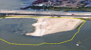
The EPA wants to remove about 202,000 cubic yards of contaminated material (roughly enough to fill the floor of the Astrodome with a 13-foot-deep layer) but says it’ll have to be done carefully so as not to accidentally stir up the waste into the surrounding river while trying to get it out; the removal would also probably take place in stages to avoid potentially exposing too much of the waste at a time to storms or flooding. Here’s the EPA’s map of the 2 sites where the paper sludge was originally dumped in the 1960s — the (capped) northern area is outlined in blue and labeled Cap Site, while the southern site (outlined in yellow and labled Southern Impoundment) is covered in part by the Glendale Boatworks building, next to Southwest Shipyard:
Not Keeping a Lid on It

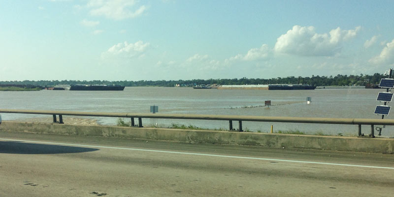
Another effect of the Memorial Day weekend and early June floods: the EPA says it has had to pause some of its latest study efforts near the 1960s industrial waste pits in the San Jacinto river (shown at the top looking a bit more submerged than usual on May 31, facing north from the I-10 bridge). New rounds of sample-taking were triggered by the discovery in December that the Superfund site’s armored cap (which is made of special tarp material held down by a layer of rocks) had a 25-ft.-long hole where the rocks were missing. The EPA also notes that the damage was found within an area of the cap where no tarp was actually initially placed, in light of concerns that the rocks would slide off of it.Â
More Fun With Superfund

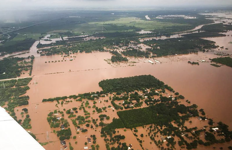
TxDOT has been doing some circling around over the thoroughly soaked Brazos River valley this week grabbing a few snapshots, including some taken yesterday morning as 31 East and Central Texas counties picked up flood-related disaster declarations from the governor’s office. Running north-to-south (right-to-left) under the murky waters shown above is FM 723 in Rosenberg, TX; you can spot the bridge rising up to cross the river’s normal channel on the left side of the photo, while SH 36 stretches away to the northwest.
Flash- and non-flash flood warnings are in effect around the region through at least Friday night, depending on how intense the rest of this week’s predicted downpours turn out to be. Meanwhile, the already-feet-past-the-previous-record flood gauge at nearby Richmond, TX, is still creeping upward this morning toward 55 ft.:
Water Under the Bridges

COMMENT OF THE DAY: THOSE I-45 EXPRESS LANE PLANS ARE CUTE NOW BUT JUST WAIT UNTIL THEY GROW UP  “Fine with these updates, provided the Pierce [Elevated] still gets torn down. Express lanes might seem like a good idea, but they’ll most likely be hindered by limited ingress/egress and often shunpiked. I’d imagine they’ll also be pretty expensive owing to the proposed modifications to the design. It’s a good design if you’re trying to center transportation around private auto use, but at some point, that can’t be the primary design consideration anymore.” [TMR, commenting on What Happens When You Decide To Redo That Downtown Freeway Plan in Your Spare Time] Photo of Pierce Elevated: Russell Hancock

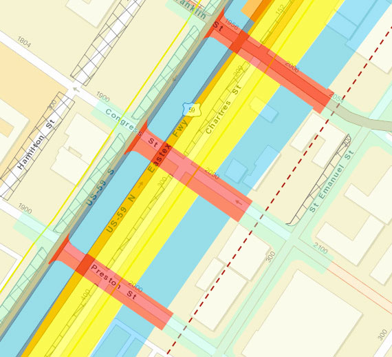
A dotted line runs right along the inside edge of the Cheek-Neal Coffee Company’s former roasting plant at 2017 Preston St. at the corner with St. Emanuel St., which was declared a protected city landmark today after starts to the building’s redevelopment by new owners last year. The line marks the proposed right-of-way for TxDOT’s plans to reroute I-45 alongside 59 and send the Pierce Elevated out to pasture, as shown in update documents released in September. The 1917 building shows up as a beige box at the corner of Preston and St. Emanuel in the above capture from the project’s interactive online map system, and the seafoam green highlighting to the left indicates the newly planned frontage roads that would run to the west of it.
But the Cheek-Neal building itself actually doesn’t appear to be on the chopping block. The blue highlighting indicating the future path of freeway lanes skirt the western edge of the structure (though they appear to engulf the Loaves and Fishes soup kitchen across Congress St. to the north). Moreover, a cross-section through the I-45-59 bundle specifically shows the building in place, with the frontage road to the east and the freeways tucked out of sight below ground level:
Preservation on Preston

COMMENT OF THE DAY: VISIONS OF A FREEWAY LINED WITH OFFICE BUILDINGS  “I live in the area and I think it’s a big improvement on a used car lot. I would love to see the remaining car dealerships gradually moved away and a continuous strip of mid/high rises from Memorial City to Hwy 6. Now that would be a true ‘Energy Corridor.’†[outwest, commenting on A New 17-Story Office Tower Just Like the Others in the Energy Corridor] Illustration: Lulu


 Sharing Benignus Plaza with Jason’s Deli, Texas State Optical, and a salon, this 2,500-sq.-ft. suite at 10321 Katy Freeway will be the first Club Champion store in Texas. The Chicago-based company sells custom golf clubs built to fit, and it provides a demo space for practice. Sitting just east of Town & Country Village, the Benignus Plaza store will be almost directly across I-10 from Hicks Ventures’ proposed Block 10 West Office Park.
- Previously on Swamplot:Â Great New Indoors Replacing The Old Great Indoors
Photos: Swamplot inbox


If you like intensely cinematic video renderings of former housewares stores set to a really rocking soundtrack, you’re going to love this one: It’s Block 10 West Office Park! This screenshot from the video shows how developer Hicks Ventures plans to maintain fidelity to the original I-10 site near Beltway 8, retaining the parking lot that used to front the former Great Indoors, which Sears sold along with 9 other stores about a year ago.

MANAGING THE NEW KATY FREEWAY MANAGED LANES Those new center sorta-HOV lanes on the new Katy Freeway will go toll starting this weekend. Here’s a little primer to help you make intelligent purchase decisions at 65 mph or more: “The lanes will now be open 24 hours a day, 7 days a week. Outside of rush hours, they’re a toll road: every car, regardless of how many people are in it, pays $1.10 to go the full length of the lanes. During rush hour, in the rush hour direction, single occupant cars pay between $2.00 and $4.00 and 2+ carpools are free. Those rates will need to be adjusted if the lanes are too popular, because HCTRA (who operates the lanes) has promised METRO (who gave up the HOV lane to make room for them) that buses will keep moving at full speed. Single occupant vehicles and carpools will be sorted out by a three-lane toll plaza: left lane for carpools, right two lanes for SOVs.” [Intermodality; details]

In this episode: Katy Freeway anthill mover, moon-unit coffee, and that robot on the porch.
What’s this special delivery rushing down I-10?

KATY FREEWAY REPORT “Has anyone else noticed that traffic on I-10 is still not great? I have a ‘reverse’ commute on I-10 every day. Before the expansion traffic was fine inside the loop outbound in the morning, slow outside the loop. Inbound in the evening it was slow outside the loop, fine inside, except near the 10-45 interchange. Now things are much smoother outbound, no delay at all. Inbound, however, is a nightmare. Traffic comes to nearly a complete stop approaching the 10-45 interchange, and is usually very slow all the way back to Shepherd / Durham. Observing the ‘regular’ commuters across the median, things are of course worse. In the mornings the backup to get onto the loop or through the 10-45 interchange is insane, it’s bad in the evenings as well.” [NeoHouston]
KATY FREEWAY TOLL LANES: PAY AS YOU GO Those new HOV-ish lanes in the center of the new Katy Freeway will have a price tag attached to them by around May or so — but Harris County commissioners haven’t yet decided what it’ll be: “The county intends to use a flexible-rate system based on congestion, called dynamic pricing. Initially, certain rates will be set for rush-hour commutes, and different prices may be set for other periods. After about 90-days, the prices may change based on traffic observations. Signs near the entrances to the Katy Freeway lanes will announce the rates. Carpoolers and other high-occupancy vehicles will be able to access the Katy toll road for free during peak hours through designated lanes along the freeway. They will not be required to use toll tags — an electronic toll collection system that drivers display on their windshields — or to register with the county’s toll authority. The Katy Freeway carpool drivers must use the left-lanes only.” [Houston Chronicle, via Off the Kuff]