
- 1901 Southwood Dr. [HAR]
EPA: YEAH, BETTER CLEAN OUT THE DIOXIN PITS FROM THE SAN JACINTO RIVER NOW THAT THEY’VE LEAKED A bit later than had been urged by those alarmed by the longterm presence of pits full of toxic waste sealed only with a tarp on top hanging out in the San Jacinto River, the EPA has now approved a plan to remove most of the dioxin stored within them. “As exemplified today, EPA is prioritizing Superfund clean-up by making decisions in a decisive, timely manner,” reads a statement from administrator Scott Pruitt released this afternoon. “The San Jacinto Waste Pits site was added to the National Priority List nearly a decade ago.” What’s the rush? As predicted by EPA studies and many a casual observer, the pits appeared to have leaked extensively after Hurricane Harvey flooding. Under the new $115 million plan, cofferdams will be installed around the pits and almost 212,000 cubic yards of dioxin-contaminated material will be excavated — leaving just enough behind that the agency can, it says, ensure controls that will “prevent access, eliminate off-site migration, and monitor the natural recovery into the future.” [EPA; more info; Houston Chronicle; previously on Swamplot] Video of waste pits after Harvey flooding: Greg Moss
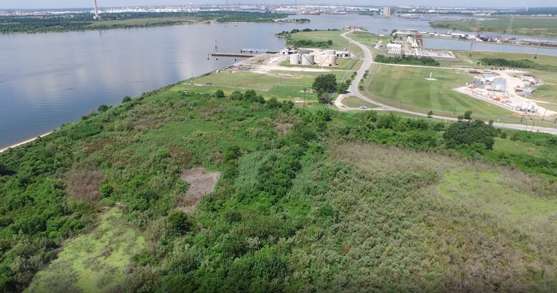
Some of the 42 acres of land just purchased for development by Avera Companies are shown here from above, east across the Ship Channel from the San Jacinto Battleground (that’s the bottom half of the star-topped obelisk visible toward the top left).  The property is on a peninsula of land about 2 miles downstream from the I-10 bridge and the San Jacinto Waste Pits. The eastern terminal of the Lynchburg Ferry can be seen here at the end of Independence Highway, with the Lynchburg reservoir lying  to the north.
The company says Kirby Inland Marine is set to be the first tenant for the property, and will use a section of the property to let up to 76 barges tie up and hang out as necessary. Kirby just agreed last month to a $4.9-million settlement with the Department of Justice over its role in that March 2014 barge-meets-carrier oil spill that shut down the Port for a few days and spread oil along roughly 160 miles of Texas coast between Galveston Bay and Padre Island National Seashore. (Kirby Offshore Marine, another of the corporation’s subdivisions, is currently dealing with fallout from last week’s tugboat-meets-shore fuel spill off the coast of British Columbia.)
Here’s a view of the rest of the property, showing a bit of Burnet Bay on the left and the San Jacinto River upstream toward I-10 on the right:
Here’s some raw footage from a camera-wielding drone flight landscape artist and researcher Steve Rowell piloted earlier this year over portions of the Baytown Nature Center, the Crystal, Scott, and Burnet Bay peninsula that not too long ago was the home of the tony Brownwood subdivision — before it got all sinky and decided to subside 10 or so feet into the water. In some portions of the video, you can still spot the occasional home or garage slab from a fifties- or sixties-era rancher or 2, not to mention concrete broken up from other foundations and driveways and recycled on-site into surge barriers that now control the more recent, court-ordered wetlands environment.

There had to have been a pretty good view of the developing oil business from the back windows of this home. It was built in 1843 on the eastern bank of Goose Creek in what’s now Baytown, and probably enjoyed those first quiet 60 years before anyone suspected there’d be any oil back there. A little after 1916, though, it must have smelled pretty nasty, backing up to the state’s first offshore oil field.
It went on the market as an estate sale in August: first at $89,000, then lower after a $10K price cut in November. Someone put a contract on it late last week.
ANOTHER BAYTOWN DROP City council members in Baytown are meeting this morning to try to figure out what to do about a sinkhole that’s opened up next to a sewer line that runs adjacent to a bend in Goose Creek. abc13 reported last night that the sinkhole was caused by a rupture in the line, but that repair work had already begun. [abc13]
HOW TO PREPARE SAN JAC RIVER STEW What’s the local recipe for that San Jacinto River fishin’ favorite, toxic redfish? “The dioxins come from submerged waste pits north of the Interstate 10 bridge. McGinnes Industrial Maintenance Corp., which is no longer in business, owned and operated the pits in the 1960s, filling a 20-acre site on dry land with waste from a now-closed paper mill near the Washburn Tunnel. In the bleaching process, paper mills generated large amounts of dioxins, a family of compounds so toxic that scientists measure them in trillionths of a gram. The EPA says there is no safe level of exposure to the chemicals, which are known to cause cancer and disrupt immune and reproductive systems. The San Jacinto River began to run through the waste pits by the early 1970s because of subsidence — the sinking of soft soils as water is pumped from underground. With the McGinnes pits under water, the dioxins spread into the river and worked their way through the ecosystem, becoming more concentrated at each step in the food chain. For more than a decade, the Texas Department of Health has warned that fish and crab caught along this stretch of water, north of the Lynchburg Ferry, are tainted with cancer-causing dioxin, pesticides and PCBs. . . . In July, the EPA identified the International Paper Co. and McGinnes, which became part of Waste Management through a series of mergers and acquisitions, as the firms responsible for the dioxins problem. Under the Superfund law, the two companies will be required to evaluate and clean up the contamination. They paid about $65,000 for the fencing and roughly 50 warning signs in English, Spanish and Vietnamese, a McGinnes spokesman said.” [Houston Chronicle]
TODAY’S ODOR IN BAYTOWN IS BROUGHT TO YOU BY EXXONMOBIL The most recent smell, of rotten eggs, has been claimed by the folks at ExxonMobil’s Baytown Refinery. Fortunately, local news outlet Reuters UK is on the story, filing one of the few reports on the incident, which we quote here in full: “Exxon Mobil said Wednesday there was an operational issue at its 562,500 barrel-per-day refinery in Baytown, Texas but gave no details as to the scope and units involved. ‘I can tell you there was no impact to production,’ said Kevin Allexon, a spokesman for the company.” [Reuters UK]

So much new stuff going on it’s impossible to keep track of it all!
a bright and refreshing dining room, festive bar and side street patio. We will eventually offer curbside “to go” service.
And yet even more new stuff:
ANOTHER RIVER RUNS THROUGH BAYTOWN Oil spill on the bayou: “The spill spread from an oil storage tank in the Mont Belvieu area, leaking into Smith Gully then on to Cedar Bayou. Mont Belvieu’s Emergency Management Chief Bruce Oliphant said best estimates put the spilled oil at 200 to 300 gallons but said a reason for the leak had not been determined by Tuesday afternoon. ‘We’re not sure why it leaked,’ Oliphant said. ‘We couldn’t see where it was coming from the tank and maybe it was coming from somewhere underground.’†[Baytown Sun]

Where is this house?
Two of you guessed River Oaks and 2 more guessed Old Town Spring. And here were the rest of your guesses: Shady Acres, Nottingham, “one of the Villages out in Memorial,” “an early Memorial development,” “close to or on Kimberley, Barryknoll, Kirkwood, or Wilcrest,” Ashford Forest, Woodcreek off Aldine-Westfield, “between Shepherd and Montrose, Westheimer and Gray,” Bellaire, “somewhere on the bay,” Bellville, Brookshire, Columbus, Brenham, “Tomball-ish,” Wilchester, Wilchester West, on Chimney Rock near Memorial, Cypress, “along 1960 areas that are older,” “older parts of Deer Park or somewhere over there,” Galveston, “off Westview across the freeway from Memorial,” Friendswood, “the oldest part of Kingwood off Northpark,” Porter, “up high on a bluff in Morgan’s Point,” “in the vicinity of Holcombe and Greenbriar,” Braes Heights, and “somewhere around Braeswood.”
This week’s Neighborhood Guessing Game was just for the glory. And the winner? Glory, glory, it’s elnina, who caps off a remarkable streak of dead-on entries with a third win this year. (There were a couple of second-places in there too.) Here’s the vague but closer-than-anybody-else winning entry:
This looks like a country, two-story house, with large floor plan on a lot with a pool.
The spacious rooms downstairs have brick floors and upstairs bedrooms – wood floors. Nice stencils accents throughout the house.
No clocks, radios or TV’s, except a small unit in the bedroom (lol).
I can spot few recent updates – like windows, kitchen appliances, nice marble counter in the bathroom, plantation shutters. But when I look at the brick floors, the condition of the wood on the floors and stairs, the fireplace and the painted paneling, I would say that this house is probably 40-50 years old.
I guess it is sitting in a flood zone, close to bayou or the coast. The picture with the ship makes me think that big water is not far away. Maybe somewhere on the bay?
Congratulations, elnina! You’ve won . . . first prize!
Our runners-up this week are Miz Brooke Smith, with a close-but-wrong-bank Morgan’s Point guess, and Jessica1, who wrote this:
I don’t know what y’all are thinking with the nottingham, wilchester, etc. guesses – I grew up out there and never saw anything quite like this. The wood floors are too old, at least for my part of the neighborhood. And those furnishings! Not energy corridor. I’m saying older parts of Deer Park or somewhere over there, only because I think I saw identical stuff in an antique store in LaPorte.
Ready for the real answer? Here it is:
IKE TURNS HERE Apparently, some sort of storm is headed this way. If you live in the 77507, 77058, 77059, 77062, 77520, 77546, 77571, 77586, or 77598 zip codes, here’s a little advice: Surfing Swamplot for real-estate news is probably not the best use of your time right now. How about a little gettin’-out-of-town-ing instead? There’ll be plenty of time to gawk at photos of soggy homes right here — after we’ve been soaked and the power comes back on. On the other hand, all you shelter-in-place people: How’s the installation coming along on those foundation bolts and jacks? Got any tips for turning decorative shutters into something . . . useful? And who’s been buying up all the toilet paper? [Houston Chronicle]
BAYTOWN MOSQUITO REPORT, IN LANDINGS PER MINUTE “. . . while Baytonians might feel like the mosquitoes are out in droves, Director of the Baytown Health Department, Mike Lester, said what we’re really seeing is a return to ‘normal.’ ‘For the last couple of years we’ve been really fortunate that the weather has been good to us,’ he said. ‘Even though people might think it’s bad right now, the pest rate is between five and 20 landings per minute, which is average for this time of year.’ Lester explained that there are generally three peak ‘hatch-outs’ during the 11-month Gulf Coast mosquito season: May, August and November. During those months, mosquitoes hatch and mature, infesting Baytonian air for a few weeks before they give way to the next generation of larvae.” Why isn’t this kind of report a regular feature? [Baytown Sun]


