A FLOOD OF CHRISTMAS DINERS AT VIETOPIA An impromptu performance surrounding a centerpiece aquarium greeted Christmas dinner diners at Vietopia yesterday. Loud screams accompanied the appearance of twin streams springing from a leak in the glass on the dining side of freestanding structure at the Vietnamese restaurant in the Plaza in the Park (better known as the Kroger shopping center just south of the Southwest Fwy. on Buffalo Spdwy.) As a steady fountain of fishwater aimed itself at a nearby table or 2, the restaurant’s staff sprung into action: Large plastic garbage cans were deployed quickly to catch the water, and waiters used nets to collect the fish and transport them to new homes. [Wendy G Young Lightwalker, via abc13] Video: Wendy G Young LightWalker
Hazards
OCCASIONAL HAZARDS OF A FEEDER ROAD STRIP CENTER 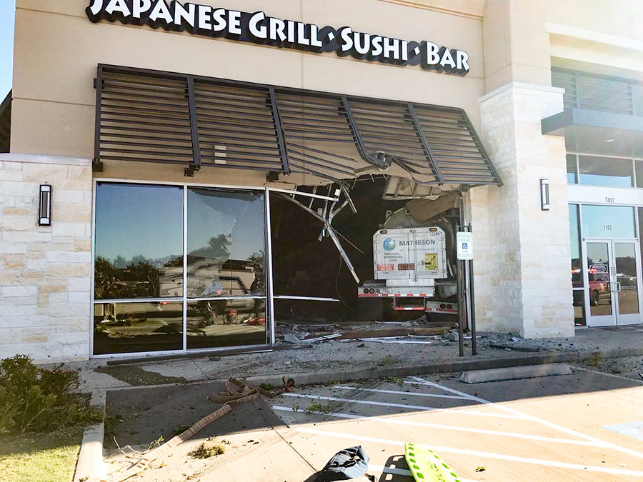 The Shogun Japanese Grill and Sushi Bar in a strip center fronting the northbound feeder of the Grand Parkway in Richmond opened its storefront involuntarily this morning to accept an oncoming 18-wheeler. The Fort Bend County Sheriff’s office has sent out the photo shown here of the restaurant at 7417 W. Grand Parkway South, showing the truck swallowed completely by the restaurant. The adjacent Gossip nail salon was also damaged after the truck broke through the interior wall separating the 2 businesses. According to the Sheriff’s office, the truck was carrying hazmat gasses; the words “nitrogen refrigerated liquid” are visible on the back of the trailer in the photo. The driver is in critical condition, and 3 people who were in the building suffered “minor injuries,” according to the report. The building has been evacuated. Update, 11:45 am: More from the Sheriff’s office: “The driver of the 18-wheeler has passed. We believe the crash was caused by a medical issue he was experiencing.” [FBCSO] Photo: Fort Bend County Sheriff’s Office.
COMMENT OF THE DAY: BEHIND THE ‘EVERYBODY OUT’ ORDER AT 2100 MEMORIAL 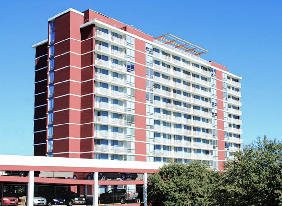 “I’ve volunteered there and can tell you the entire ‘sub-basement’ electrical/fire control room was completely submerged. I assume that entities receiving government rent subsidies must meet current NEC (nat’l elect code) standards on renovations/repairs. . . . Thus, if entire elect/fire control room is gutted/replaced then all rooms’ receptacles, fixtures, elevators, laundries . . . etc. must be replaced to meet current NEC also. I doubt you can ‘scab on’ new equipment to decades old equipment on a major renovations. Would you trust it?
You can’t make this type of systemic overhaul while residents stay in their unflooded upper floor apts. Unfortunately, for their safety they must be moved ASAP. The existing lights and limited A/C are being run off of generators. You can’t run a hi-rise indefinitely on generators.
God forbid a fire breaks out or an elevator fails due to faulty electrical system. Help is needed now finding affordable & safe housing, transport, and followup assistance. Hard enough in ‘normal’ times but that much more difficult post-Harvey.” [Steve, commenting on Residents of 2100 Memorial Senior Highrise Now Have 5 Days To Move Out of Their ‘Uninhabitable’ Apartments] Photo: 2100 Memorial
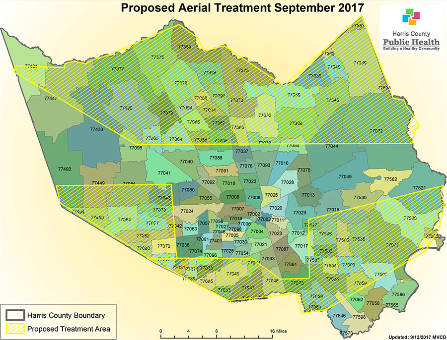
Here’s a map showing the 600,000 acres in Harris County over which the Air Force Reserve’s 910th Airlift Wing will be flying modified C-130 cargo planes staged from Kelly Air Force Base in San Antonio in order to conduct an aerial spray operation beginning Thursday evening. The marked zones to the north, south, east, and west of inside-the-Beltway Houston will be graced with a mist of Dibrom, an insecticide meant to reduce the threats posed by millions of mosquitoes arising from thousands of impromptu pools formed in Harvey’s wake. Harris County public health officials suggest persons “concerned about the exposure” — and area bees — remain indoors during the nighttime insecticide-disbursement procedure, which might take a second evening to complete.
- Aerial Mosquito Spray Operation Scheduled in Wake of Flooding [Harris County OHSEM]
Map: Harris County Public Health
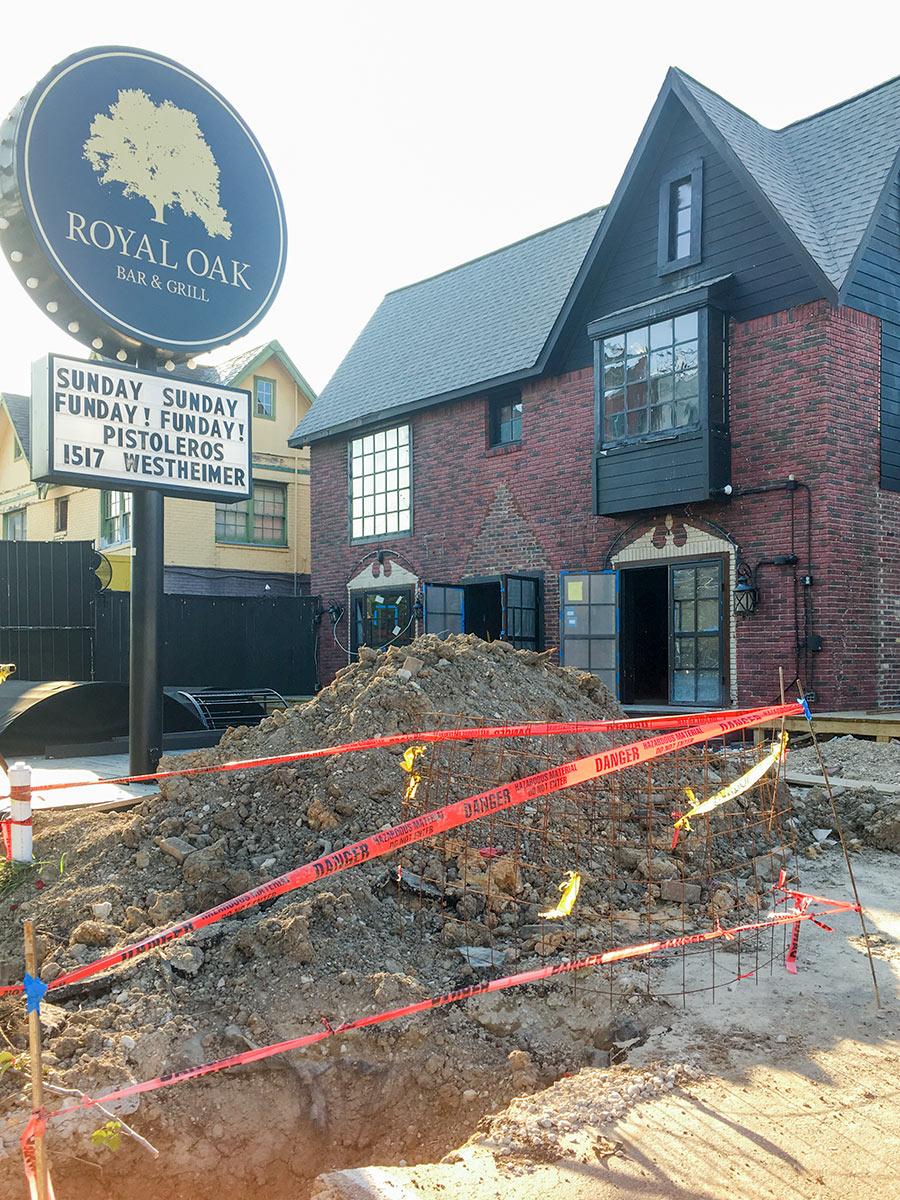

Here, courtesy of a Swamplot reader, are a few exterior views of the building at 1318 Westheimer after its weekend fire. “The damage is pretty severe,” Shawn Bermudez wrote on Facebook Saturday evening. The owner of Royal Oak Bar & Grill, which shut down in this location last September, had been renovating the property in order to reopen it as a bar named Present Company. That work was a month from completion, Bermudez estimates. Among the additions to the former 1950s home: new steel doors and windows. And here’s a view showing the current state of the new piggyback patio added in back:
 The headline suggestion in a 6-page policy paper published last week under the banner of Rice University’s Baker Institute comes in item 2 of a helpfully numbered list of 15 things Houston might want to do or think about to make future never-seen-this-before flooding events a little less catastrophic: Author Jim Blackburn, an environmental attorney, pioneering Houston-area naturalist, and longtime let’s-not-flood advocate, proposes a “fair but extensive home buyout and removal program” targeted at homes that have been flooded 3 or more times since Tropical Storm Allison in 2001: “It is unlikely we can develop strategies to protect them from severe rainfall events that are much more frequent than labels such as ‘100-year’ or even ‘500-year’ rainfall events suggest,’ he writes.
Among the less radical proposals put forward in his list is the suggestion to map and categorize the Houston region by its propensity to flood: “safe” areas that didn’t flood — and should therefore become “the backbone of the Houston of Tomorrow” — “transitional” areas (only “single-event” flooding); and “buyout” areas — which can be targeted for parks and “future green infrastructure.”
Other ideas and issues from the paper that Blackburn hopes will “initiate a conversation” are summarized here:
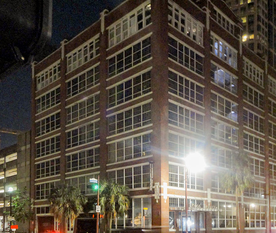
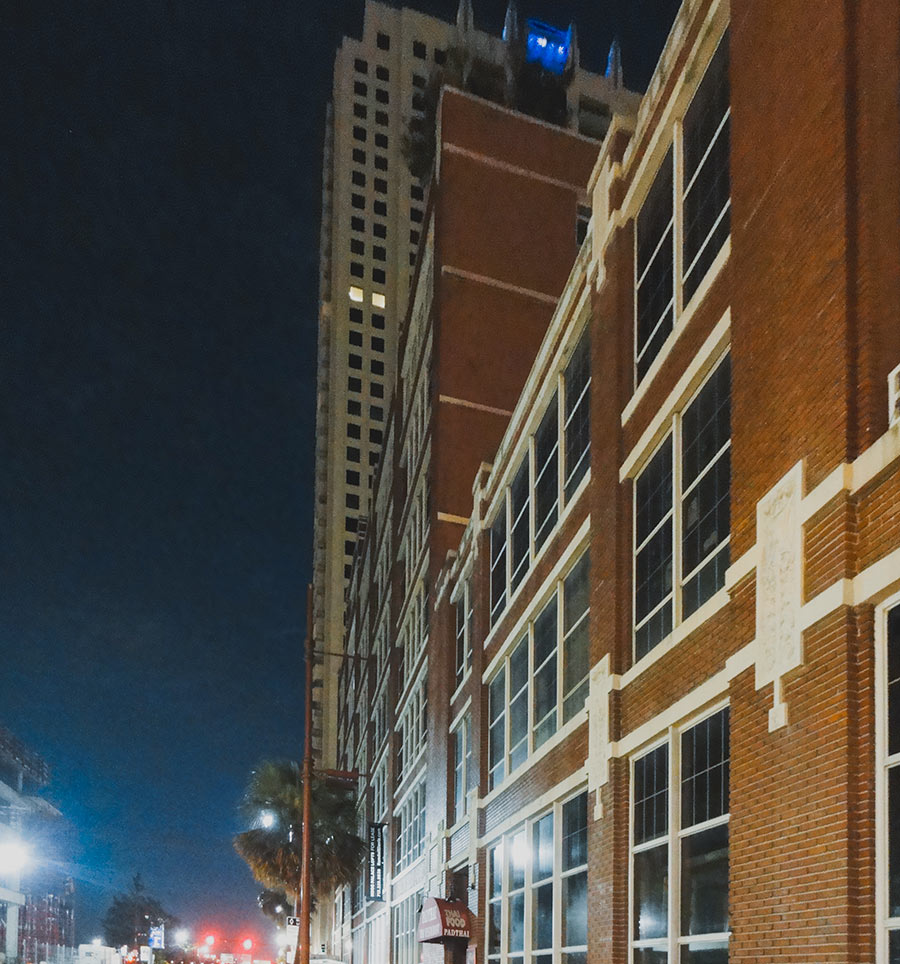
Today’s the day a 48-ft.-long trailer-mounted 1MW Aggreko generator is expected to park on the Louisiana St. side of the Hogg Palace Lofts, a Randall Davis Companies rep tells residents. The goal: Power restored in all 79 units by the end of the day. But generator power won’t be going to elevators, corridors, or the building’s retail tenants (which include the Pad Thai restaurant on Louisiana). Those areas will have to wait until replacement electrical equipment arrives and is installed to restore permanent power in the building. References to a series of so-far-unsuccessful efforts to repair existing equipment are included in a series of emails sent to residents by the building’s management over the last 2 weeks.
The 8-story building at the corner of Louisiana and Preston has been without power since around 8 am on August 27th. “What we as tenants have been able to piece together is sub-level parking levels of the Lyric Center and the new Lyric Center garage became flooded as the bayou took a short cut down Prairie and took a left on Louisiana,” a tenant tells Swamplot. Water coursed into those parking garages down entrance ramps, then “made it under the street through vaults or conduits or whatever into the basement of the Hogg where it shorted out the electrical equipment.”
SOMETHING POWERFUL IN THE CROSBY AIR 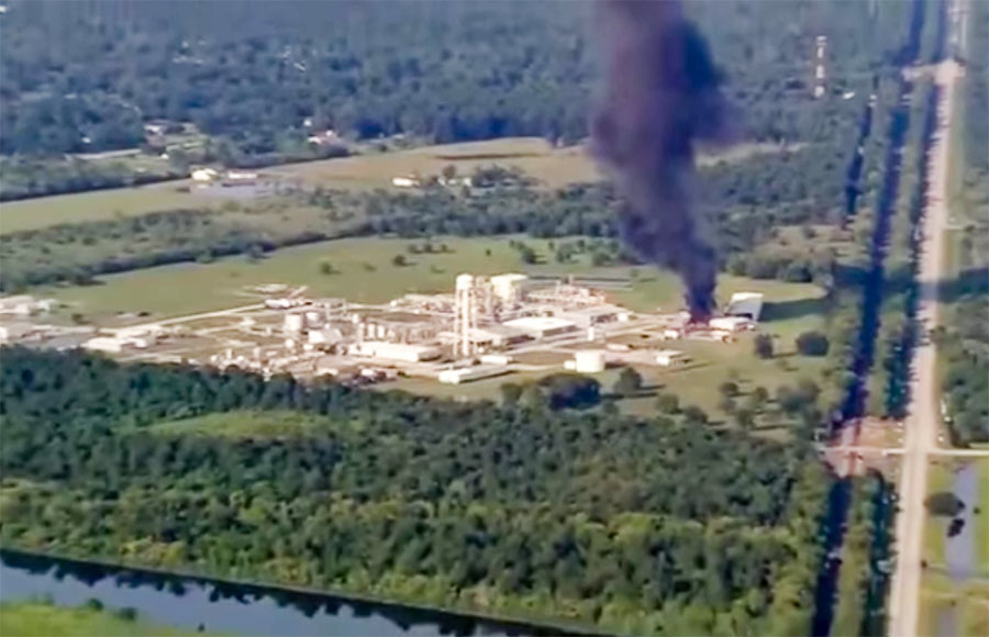 This vivid description is included in the original petition of a lawsuit filed today against Arkema, operators of the chemical plant off the Beaumont Hwy. in Crosby — by 7 first responders injured after incidents there last week: “In the early morning hours of August 31, 2017, the first of several explosions occurred as a result of the abandoned chemicals heating up and igniting. Although the explosions had occurred, no one from Arkema alerted the first responders who were manning the perimeter of the arbitrary mandatory evacuation area. Immediately upon being exposed to the fumes from the explosion. and one by one. the police officers and first responders began to fall ill in the middle of the road. Calls for medics were made, but still no one from Arkema warned of the toxic fumes in the air. Emergency medical personnel arrived on scene. and even before exiting their vehicle, they became overcome by the fumes as well. The scene was nothing less than chaos. Police officers were doubled over vomiting, unable to breathe. Medical personnel, in their attempts to provide assistance to the officers became overwhelmed and they too began to vomit and gasp for air. Some of the police officers. unable to abandon their vehicles due to their weapons being present, jumped in their vehicles and drove themselves to the nearest hospital. The other officers and medical personnel were all placed in an ambulance, and were driven to the hospital.†[Houston Chronicle; International Business Times] Still image of smoke from fire after Thursday’s explosion: abc13
By late afternoon on Sunday, August 27th, there were 2 ways out of several of the 3-story buildings at the Meyergrove Apartments at 4605 N. Braeswood — which back up to Brays Bayou in the southwest corner of the 610 Loop. There was rescue by boat (above) — from which you’d arrive to safety on a dry portion of the freeway:
The map above outlines the actual locations of neighborhoods designated by officials yesterday as being at risk from flooding over the back sides of Houston’s dual Buffalo Bayou reservoirs — in advance of actual spillovers, which began last night and continued this morning. The map was put together by Chronicle data reporter John D. Harden, using information from the Harris County Flood Control District. Zoom in and you can identify specific streets and neighborhoods on the upstream side of Addicks (in red) and Barker (in blue) reservoirs.
Names of the affected neighborhoods are listed on the map’s fly-out panel, available by clicking on the icon at the top left corner of the map. Click on the icon at the top right corner to enlarge the map if you need to.
To lessen the risk of flooding to these areas, officials have been releasing water out the other end, through the Addicks and Barker dams into Buffalo Bayou — possibly (depending on bayou water levels) endangering neighborhoods and structures downstream.
- A weary Houston likely to endure catastrophic flooding through Wednesday [Houston Chronicle]
- Officials fear rising rivers, failing levees [Houston Chronicle]
Map: Houston Chronicle
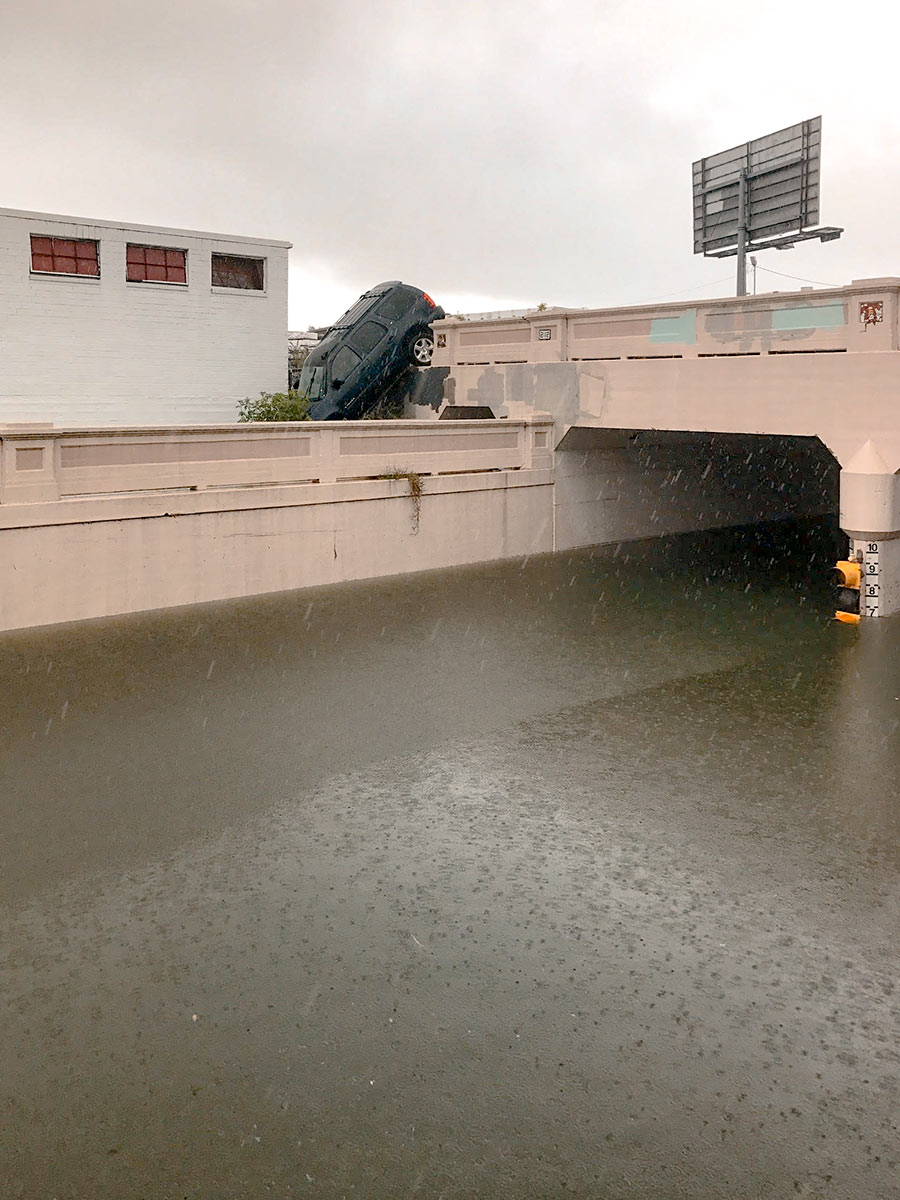
Water levels from Harvey have made the underpass just north of Center St., where Houston Ave. tucks under the rail lines, impassable. But there are consequences to trying to drive around the underpass structure, as this photo taken yesterday afternoon by a Swamplot reader attests: The ground drops off sharply on the south side of the tracks to the west of the street, and that’s not so easy to see if you’re driving south.
Photo: Kelsie H. Dos Santos
HARVEY NOW PREPPING FOR SOME SERIOUS GULF COAST HUNKERING OF ITS OWN 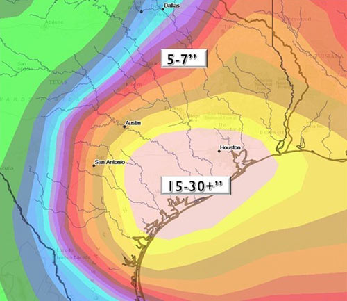 The “most likely scenario” now predicted for Hurricane Harvey is a 5-day-long visit to southeast Texas, during which the storm will spend its time sucking up moisture from the Gulf of Mexico and heaving it landward. “Expect floods. Lots of flooding,” writes Eric Berger in this afternoon’s Space City Weather update: “Like widespread 10 to 25 inches of rain over the next five or six days. Or maybe more. That means you, Pearland. Take a bow, Katy. You’re on deck too, Baytown. Have some water, League City. Looking at you up there in The Woodlands, too.” [Space City Weather] Graphic: National Weather Service
SANDBAGGING IN MEYERLAND 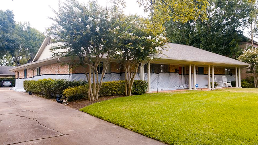 What kind of person would pay close to $5,000 to have 18,000 pounds of sandbags delivered and installed in a low stack in front of a 5-ft.-high waterproofing barrier surrounding her home? The owner of a Meyerland single-story 4-bedroom (pictured above) 1 block south of Brays Bayou that flooded “for the first time” in the Memorial Day deluge of 2015 (according to a real estate listing of that year) and then twice more in the past year or so. “This may not even work,” Kristin Massey tells Houston Public Media’s Marissa Cummings. “It’s just an effort to hope that it will.†Massey says she would have installed more sandbags if more had been available: “I would have liked to have gone higher than 11 inches, but I have about half or a third of what I need.” [Houston Public Media] Photo: Houston Public Media
SWAMPLOT WANTS YOUR PRE-FLOODING, FLOODING, AND POST-FLOODING PHOTOS 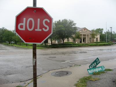 Houston’s first hurricane of the smartphone-carry era is almost upon us. Plus, at least a few of you will have drones at the ready this time (once the winds subside, of course). It all adds up to a grand possibility: Houston’s best-documented storm aftermath ever. Whichever direction you end up hunkering this long weekend, stay safe! But when the hazards recede and you venture out to see what’s up in or around your neighborhood, snap some pics or vids of notable sights and send them to Swamplot! Our tips line is always open. You can also upload photos or short videos to the Swamplot Flickr pool — or send us a link to videos you’ve uploaded to YouTube. We want to see images you’ve taken yourself. Please let us know where they were taken, and whether you’d like to be credited if we publish any of them. What we’d all like to see: high-water marks, low points, sequences; scenes you wouldn’t see unless you were in the middle of a famously flat, low-lying city after a big storm. Tell us a story! Photo of Kirby Dr. after Hurricane Ike: Swamplot inbox
THE BIG WET PICTURE FOR A POSSIBLE HARVEY HANGOUT 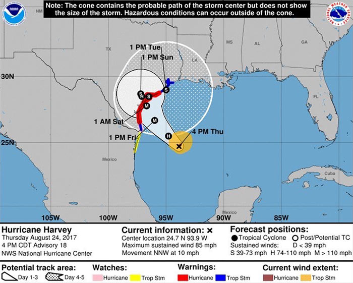 A Hurricane Harvey shown veering slightly further to the east than previous reports suggested is now expected to reach the Texas coast late Friday night or early Saturday morning as close as 125 miles southwest of Houston — with a rating at the high end of Category 3. But heavy rainfall could continue for days if the storm stalls or retreats instead of moving inland and clings to the coastline as it travels east. The National Weather Service now expects flooding in the Greater Houston area and points east to continue through Tuesday, with rainfall ranging from 15 to 25 in. [Space City Weather; National Weather Service] Image: National Weather Service

