CITY: WE OWN THE BROADACRES ESPLANADES; HOA PREZ: NEIGHBORHOOD TRUST OWNS THE GRASS  The Houston Public Works department confirms in a press release that the esplanades and streets on North, South, and West boulevards in Broadacres are in the public right-of-way. But lookie here what Diane Cowen at the Chronicle reports: “Cece Fowler, president of the Broadacres HOA, said that it’s been determined that while the city owns the streets on North, South and West boulevards as well as the brick sidewalks that run down the middle of the esplanades, the Broadacres Trust owns the grass.” Also, according to Cowen, the park along Parkway Dr. is owned by the trust. The HOA placed NO PHOTO SHOOTS signs along the esplanades and in the park last Thursday, but removed some of them over the weekend. The rest were taken down on Monday, ahead of the city’s statement that “The public ROW is available for anyone in the community to use for legal activities, including personal photography. Signs and blocking the public ROW are not allowed without specific permission from the City of Houston.” The signs — 13 total according to Cowen — cost the HOA $1,300. [Houston Chronicle; previously on Swamplot] Photo: Swamplot inbox
Sign up for the Newsletter
Tag: Photography

BROADACRES HOA TAKES DOWN ITS ESPLANADE NO-PHOTOSHOOT SIGNS  The Broadacres Homeowners Association has removed all signs posted on the esplanades along North, South, and West boulevards welcoming visitors and telling them photoshoots are prohibited. As to whether the esplanades are public or private property — that’s still up in the air: “The homeowners association said the property was deeded to the group in the 1920s, and is looking for the documentation to enforce its ban.” The HOA initially placed the 11 signs on the esplanades last Thursday. [abc13; Previously on Swamplot]Â Photo: Swamplot inbox

COMMENT OF THE DAY: THE NORTH AND SOUTH BLVD. PHOTOSHOOT BATTLE IS JUST WARMING UP  “As a close relative of a Broadacres resident I will report what I know. Yes, the esplanades are privately owned and maintained by the homeowners and the signs are legal. The reason for the signs was the volume of people taking pictures. I have lived there for 15+ years and it has never been this bad. In the evenings you will have 2, 3, or 4 groups of people on each block taking pictures and it’s not just people that are the problem, it’s all of the props (sofa, chairs, tables, GLITTER, lighting) that they bring with them too. As some commenters have pointed out, some homeowners have approached those taking pictures and gotten back a lot of attitude and some form of “This is public property.†Err, well, no it isn’t actually. The signs were a compromise to discourage further pictures and serve as an initial educational campaign. If it backfires or the signs are ignored there will most likely be some sort of security enforced permitting in place or, the nuclear option, buying out the streets from the city and gating the neighborhood.” [BroadAcres Brat, commenting on New Signs Declare Photo Shoots Will No Longer Be Allowed on North and South Boulevards] Photo: Swamplot inbox


Quick, name your Top 10 quintessential images of Houston. The Water Wall, maybe? Buffalo Bayou Park looking toward downtown? And how about one of those aerial views of flooded neighborhoods? But what about a view more likely to spur real estate sales, like the double rows of coastal live oaks lining North and South boulevards in Broadacres?
A new set of signs erected this week in the boulevards’ iconic esplanades have something to say about that often seen scene: “WELCOME TO BROADACRES,” they read, “NO PHOTO SHOOTS.” The signs go on to describe other local menaces such as unleashed dogs and their residue, and note that the esplanades as well as the park on the east side of Parkway Dr. are privately owned.
Brides Be Gone

Here’s a commandeerable after-and-before flooding shot, taken from a drone hovering 300 ft. above Hwy. 6 just north of the Barker Reservoir spillway. Move the slider at the bottom of the image to toggle slowly between the 2 views, taken Thursday, August 24th (on the right, not long before the arrival of Hurricane Harvey) and Tuesday, August 29th (on the left, after stormwater filled the reservoir and the flooded the area). You can also rotate and zoom the image with your pointing device or finger.
In the initial view, the camera is facing straight down Addicks-Howell Rd.; the wider Hwy. 6 appears to veer off to the left. Addicks-Howell marks the entrance to Fleetwood, the adjacent neighborhood. Rotate the view 180 degrees to see the spillway.
Houston visualization firm Reality Imaging & Mapping Technologies took the panoramic images and stitched them together to create the immersive and zoomable view, which can also be experienced as a VR image. Click here to view the image in its own browser window.
Image: Reality Imaging & Mapping Technologies
Harvey Media

SWAMPLOT WANTS YOUR PRE-FLOODING, FLOODING, AND POST-FLOODING PHOTOS  Houston’s first hurricane of the smartphone-carry era is almost upon us. Plus, at least a few of you will have drones at the ready this time (once the winds subside, of course). It all adds up to a grand possibility: Houston’s best-documented storm aftermath ever. Whichever direction you end up hunkering this long weekend, stay safe! But when the hazards recede and you venture out to see what’s up in or around your neighborhood, snap some pics or vids of notable sights and send them to Swamplot! Our tips line is always open. You can also upload photos or short videos to the Swamplot Flickr pool — or send us a link to videos you’ve uploaded to YouTube. We want to see images you’ve taken yourself. Please let us know where they were taken, and whether you’d like to be credited if we publish any of them. What we’d all like to see: high-water marks, low points, sequences; scenes you wouldn’t see unless you were in the middle of a famously flat, low-lying city after a big storm. Tell us a story! Photo of Kirby Dr. after Hurricane Ike: Swamplot inbox

Some of the bloggers and photographers at clothing and trendy-places-to-go blog Wear+Where+Well (based in but not exclusively on Houston) have pulled together a long list of the mural walls found around town, complete with titles, artist names, photos, and the interactive map above. The list is annotated with an eye for photography conditions, as well as info on parking and on the likelihood of “indigents asking for spare change” nearby. The authors say the list will be updated frequently; info on how to submit new spots you think should be included can be found at the bottom of the document.
Map of Houston murals: Wear+Where+Well
Mural Mapping

HOW A FORMER ENRON TRADER BROUGHT HI-RES AERIAL SURVEILLANCE TO BALTIMORE 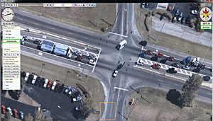 A report from Monte Reel this week reveals that the Baltimore police department has been running a secret surveillance-by-Cessna program since January, with funding from the Houston-based Laura and John Arnold Foundation, the philanthropic organization owned by former Enron trader and Centaurus Advisors founder John Arnold and his wife. The couple, which has put funding toward causes ranging from pension reform to the KIPP charter schools to police body camera use studies, contacted Ross McNutt, whose company Persistent Surveillance Systems developed out of his plane-based surveillance projects intended to investigate roadside bombings in mid-2000s Iraq. After the company was featured by Radiolab, McNutt “got an e-mail on behalf of [the Arnolds, who] told McNutt that if he could find a city that would allow the company to fly for several months, they would donate the money to keep the plane in the air.  . . . ‘We settled in on Baltimore because it was ready, it was willing, and it was just post-Freddie Gray,’ McNutt says.” The plane, which can grab images over a 30-square-mile area, has been secretly flying over Baltimore for up to 10 hours per day, sending back photos at a rate of 1 shot per second. [Bloomberg] Capture of PSS law enforcement support system: Persistent Surveillance Systems

- 4813 Palmetto St. [HAR]

DEPT. OF PUBLIC SAFETY TO UT: PLEASE DITCH THE PHOTOS OF FLOOD-RELATED CHEMICAL SPILLS WE DIDN’T NOTICE Meanwhile, in Austin: Texas Department of Public Safety officials have recently asked the University of Texas to remove an online collection of aerial photos taken by the Texas Civil Air Patrol during major flooding events, Marty Schladen writes in this weekend’s El Paso Times. The request comes after the Times reported earlier this spring on what appeared to be photos in the database showing a number of chemical spills not captured in any other state monitoring records, including spills along the Trinity river north of Galveston Bay; other photo sets previously on the site reportedly included shots of Houston sewage treatment plants being flooded on Tax Day, as well as possible unreported spills along the Colorado, Sabine, Red, and Pecos rivers since 2014. DPS Spokesman Tom Vinger tells the Times that pulling the photos is a matter of protecting privacy — “for example, there could be pictures of deceased individuals prior to family members being appropriately notified first,” says Vinger. Non-emergency-responders can still ask for the photos via Public Information Act request. [El Paso Times]
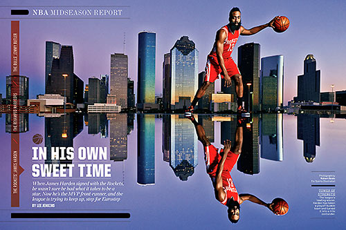
How’d the photographer get Houston Rocket star shooting guard James Harden to tower over Downtown Houston’s skyline in that Sports Illustrated spread from February (above)? Careful site selection — plus a plexiglas stage, to deal with the parapet wall:
“The editor already had a specific view in mind,” writes photographer Robert Seale, “and we referenced a rooftop fashion shot I had taken a few years earlier from that same spot. On the plus side when using a parking garage roof, you can control access which is a plus when working with a pro athlete. If we had done this out in the park, we might have gathered a crowd and needed more security guys.”
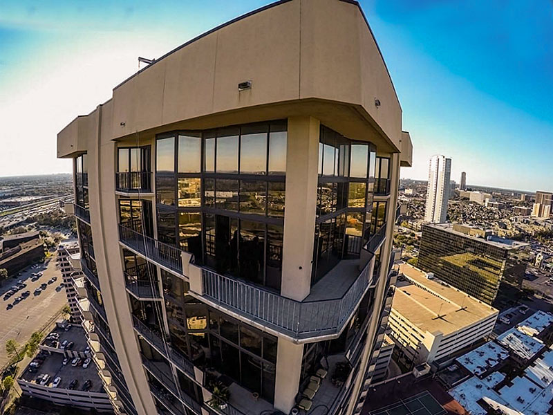
Here’s a view of the roof at the Marquis Lofts on Sabine at 150 Sabine St. just south of the Old Sixth Ward, where Seale set up the shoot:
Houston Rockets and Towers

- 3350 McCue Rd. Unit 2604 [HAR]

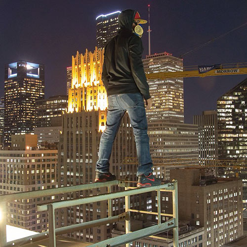
Alice Barr and her KHOU camera crew spend an authorized-by-building-management evening on top of an unnamed Downtown hotel to feature the photography and highrise hijinx of the “rooftopper” who goes by the name of Visual Contrabrand. The photographer (pictured above) tells Barr he’s afraid of heights, and that even after climbing down, glances at some of the images he’s taken “still make my palms sweaty.” But that doesn’t stop him from finding a way to access various tall structures around town (“without destroying any property,” he says) and snapping daredevil pix with his Canon 70D.
Night Pix

COMMENT OF THE DAY: HOW YOUR PHOTOS TOO CAN OOZE THAT SLICK BUT OTHER-WORLD-Y REAL ESTATE LOOK  “1.) Get a wide lens
2.) Shoot with a 7 stop bracket
3.) Comp exposures and tone in 8 bit
4.) Crank up to 32 floating point because you read somewhere that was good
5.) Boost your shadows as far as the dial will take you
6.) Compress, no, demolish your highlights
7.) Huff on nails and polish on thy hairy chest. . . . You’re now a big time real estate photographer.” [Toby, commenting on Catch All the Angles on a $1.1 Million House on a St. George Place Corner]
“1.) Get a wide lens
2.) Shoot with a 7 stop bracket
3.) Comp exposures and tone in 8 bit
4.) Crank up to 32 floating point because you read somewhere that was good
5.) Boost your shadows as far as the dial will take you
6.) Compress, no, demolish your highlights
7.) Huff on nails and polish on thy hairy chest. . . . You’re now a big time real estate photographer.” [Toby, commenting on Catch All the Angles on a $1.1 Million House on a St. George Place Corner]

COURTLANDT MANOR SITE PHOTOGRAPHER: GOOGLE PLUS ATE YOUR ‘G’ 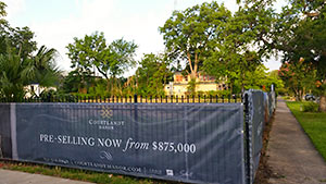 The reader who sent in pics that Swamplot posted yesterday showing a banner announcing the new 14-townhome Courtlandt Manor development at 411 Lovett Blvd. — where developer Croix Custom Homes had a 1906 mansion in fine condition torn down earlier this year — writes in to apologize and explain why they inadvertently made it look like the developer’s sign had a prominent typo. Having examined the originals and discussed the issue with one of the firms marketing the project, Swamplot can now confirm that Courtlandt Manor is indeed “pre-selling,” not “pre-sellin” units for $875K and up, and that the actual sign spells this out accurately. “I feel really bad about this,” writes the photographer, who didn’t notice anything wrong with the photo until it was posted. “My phone automatically uploads all the photos I take to Google+ for backup. When it sees several images taken side by side, it ‘auto-enhances’ them into a panorama.” That’s more of an explanation for a missing letter than Croix had provided publicly for the site’s now-missing mansion, but the spelling-oblivious auto-panorama mechanism in Google+, apparently, is a little more complicated. Original, unstitched photo of sign at Lovett Blvd. and Taft: Swamplot inbox
