COMMENT OF THE DAY: THE NORTH AND SOUTH BLVD. PHOTOSHOOT BATTLE IS JUST WARMING UP  “As a close relative of a Broadacres resident I will report what I know. Yes, the esplanades are privately owned and maintained by the homeowners and the signs are legal. The reason for the signs was the volume of people taking pictures. I have lived there for 15+ years and it has never been this bad. In the evenings you will have 2, 3, or 4 groups of people on each block taking pictures and it’s not just people that are the problem, it’s all of the props (sofa, chairs, tables, GLITTER, lighting) that they bring with them too. As some commenters have pointed out, some homeowners have approached those taking pictures and gotten back a lot of attitude and some form of “This is public property.†Err, well, no it isn’t actually. The signs were a compromise to discourage further pictures and serve as an initial educational campaign. If it backfires or the signs are ignored there will most likely be some sort of security enforced permitting in place or, the nuclear option, buying out the streets from the city and gating the neighborhood.” [BroadAcres Brat, commenting on New Signs Declare Photo Shoots Will No Longer Be Allowed on North and South Boulevards] Photo: Swamplot inbox
Sign up for the Newsletter
Photography


Quick, name your Top 10 quintessential images of Houston. The Water Wall, maybe? Buffalo Bayou Park looking toward downtown? And how about one of those aerial views of flooded neighborhoods? But what about a view more likely to spur real estate sales, like the double rows of coastal live oaks lining North and South boulevards in Broadacres?
A new set of signs erected this week in the boulevards’ iconic esplanades have something to say about that often seen scene: “WELCOME TO BROADACRES,” they read, “NO PHOTO SHOOTS.” The signs go on to describe other local menaces such as unleashed dogs and their residue, and note that the esplanades as well as the park on the east side of Parkway Dr. are privately owned.
Brides Be Gone

Here’s a commandeerable after-and-before flooding shot, taken from a drone hovering 300 ft. above Hwy. 6 just north of the Barker Reservoir spillway. Move the slider at the bottom of the image to toggle slowly between the 2 views, taken Thursday, August 24th (on the right, not long before the arrival of Hurricane Harvey) and Tuesday, August 29th (on the left, after stormwater filled the reservoir and the flooded the area). You can also rotate and zoom the image with your pointing device or finger.
In the initial view, the camera is facing straight down Addicks-Howell Rd.; the wider Hwy. 6 appears to veer off to the left. Addicks-Howell marks the entrance to Fleetwood, the adjacent neighborhood. Rotate the view 180 degrees to see the spillway.
Houston visualization firm Reality Imaging & Mapping Technologies took the panoramic images and stitched them together to create the immersive and zoomable view, which can also be experienced as a VR image. Click here to view the image in its own browser window.
Image: Reality Imaging & Mapping Technologies
Harvey Media

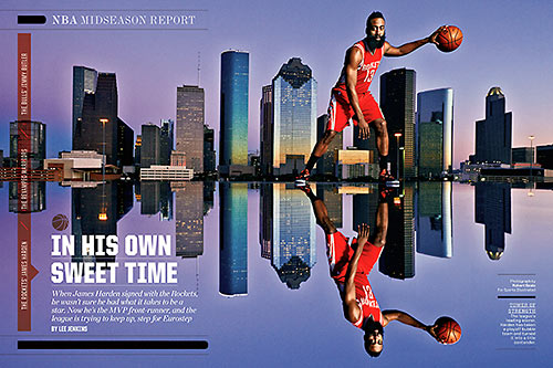
How’d the photographer get Houston Rocket star shooting guard James Harden to tower over Downtown Houston’s skyline in that Sports Illustrated spread from February (above)? Careful site selection — plus a plexiglas stage, to deal with the parapet wall:
“The editor already had a specific view in mind,” writes photographer Robert Seale, “and we referenced a rooftop fashion shot I had taken a few years earlier from that same spot. On the plus side when using a parking garage roof, you can control access which is a plus when working with a pro athlete. If we had done this out in the park, we might have gathered a crowd and needed more security guys.”
Here’s a view of the roof at the Marquis Lofts on Sabine at 150 Sabine St. just south of the Old Sixth Ward, where Seale set up the shoot:
Houston Rockets and Towers

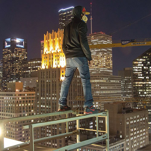
Alice Barr and her KHOU camera crew spend an authorized-by-building-management evening on top of an unnamed Downtown hotel to feature the photography and highrise hijinx of the “rooftopper” who goes by the name of Visual Contrabrand. The photographer (pictured above) tells Barr he’s afraid of heights, and that even after climbing down, glances at some of the images he’s taken “still make my palms sweaty.” But that doesn’t stop him from finding a way to access various tall structures around town (“without destroying any property,” he says) and snapping daredevil pix with his Canon 70D.
Night Pix

Who says Houston isn’t fast-paced and funky when the sun goes down? If you’ve got a minute, check out this time-lapse video made by Spenser Harrison. It takes in all the lit-up hotspots in H-Town: Main St., the Galleria, Reliant Stadium — heck, even the Pierce Elevated!
Video: Spenser Harrison
")
")
An intrepid Redditor recently explored the vacant Oakbrook Apartments and snuck away with these photos. The 222-unit complex, currently for sale, sits on 7.3 acres at 5353 De Soto St., east of Antoine and north of W. Tidwell, right up against White Oak Bayou. Writes the creative trespasser: “The majority of [the apartments] are unsecured at this point. There really didn’t seem to be much of anything left in any of the apartments, and I went in a lot of them. Most of the drywall is crumbling and you can smell the mildew from 20 yards away. Wiring and other appliances have been torn out in most of them.”


This year’s Terrain Denali, shown here in Iridium Metallic, seems to have been redesigned with a towing capacity that borders on the seismic: Apparently, it can bring the lake in along with the speed boat and dock right into the middle of the city! A vehicle that can manipulate geography according to your desires? What will they think of next? And it’s just $34,925!
- 2013 Terrain Denali [GMC]
Image: GMC


Looks like this mile and a half extension of a hike and bike trail leading north out of Terry Hershey Park is ready to go. Photos popped up on HAIF yesterday that follow the trail as it dives beneath the Katy Fwy. and banks west between Highway 6 and Eldridge Pkwy. along the Addicks Dam.
According to the Terry Hershey Park website, this extension now makes a continuous ride possible from neighborhoods around Wilcrest, Kirkwood, and Dairy Ashford to the Addicks Park and Ride to the northwest.
Here are a few more photos of what you’ll see:

")
And the celebratory stunt that the Art Guys pulled this month was walking the entire length of Little York Rd. Moving on, apparently, from their uprooting in early January at the Menil Collection, the shadowy figures Michael Galbreth and Jack Massing completed “The Longest Street in Houston” last Tuesday, walking the 29.6 miles of Little York from Mesa Road to where the concrete ends at Jasmine Crest Lane in Settlers Village.
This is some of what they saw:


The old Warwick — now Hotel ZaZa — provided one of the most beautiful views in the world, as far as Bob Hope was concerned, but that was long before photos of the Main St. hotel’s Room 322 showed up on Reddit. User joelikesmusic started a thread on Monday in which the room — booked for a colleague by mistake, apparently — is described as a “goth dungeon closet.” And the photos do reveal the room’s peculiar decor:


Ah, Friday: Why not take a stroll down Binz St. in the Museum District and have a look at what’s going on? Let’s head east from here: the corner of La Branch and Binz, near the Children’s Museum.
Our guide, Swamplot reader David Hollas, provides the photos and the observations:

")
From the Austin company that sends those little camera-wielding drones into the East Downtown sky, here are the latest views of construction progress on what you’re now supposed to call BBVA Compass Stadium. Expected completion date: sometime next May.

The scene captured last Saturday by that drone videocamera flight, showing excavation on the site of the East Downtown stadium at Texas and Dowling, plus a high-end view of Downtown’s back side . . . and a very round earth. Like a more steady ride? Here’s a still:


Got an answer to either of these reader questions? Or just want to be a sleuth for Swamplot? Here’s your chance! Add your report in a comment, or send a note to our tipline.
- Montrose: A reader wants to know if anyone has heard of any plans for the site of Mary’s Lounge at the corner of Westheimer and Yoakum — as well as the parking lot between it and Burger King. The famous Montrose club shut down last year.
- Riverside Terrace and beyond: When strangers just love your style!
My partner and I are renovating our house in Riverside Terrace, and the other day a well-mannered gentleman rang our doorbell requesting our permission to photograph our house. While we’d like to presume that his request was a compliment that our hard work is paying off, we didn’t feel comfortable with the idea of a stranger snapping photos of our house. Not knowing his true intentions, we politely declined.
Otherwise who knows where your stuff would show up?! So . . . what’s the question?
However, I know that applications such as Google Street View capture images from the public domain and make them readily available via the internet. Are there any restrictions to what we can or cannot photograph in Houston?
Photo of 1022 Westheimer Rd.: Swamplot inbox
