COMMENT OF THE DAY: MORE LOOPS FOR HOUSTON  Houston loops, 2113:
1.) 610.
2.) Beltway 8.
3.) 1960/Highway 6.
4.) Grand Parkway.
5.) Uber loop: Angelton to Rosenberg to Fulshear to Katy/Brookshire to Waller to Magnolia to Conroe to Cleveland to Liberty.
6.) Mega loop: Freeport to Bay City to El Campo / Wharton to Columbus to Brenham to Navasota to Huntsville to Liberty to Beaumont.
7.) GIGA LOOP: Port Lavaca to Victoria to Schulenberg to La Grange to Giddings to College Station to Madisonville to Crockett to Lufkin to Jasper to Orange.
8.) I-35. [DNAguy, commenting on Headlines: Astrodome Yard Sale Sellout; St. Thomas Wins Law Enforcement High; previously on Swamplot] Illustration: Lulu
Geography
COMMENTS OF THE DAY: THE CENTERS OF THE CITY  “CityCentreâ„¢ is not the center of the city. Not by a long shot.
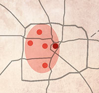
The center of population for the the city of Houston is at Kirby Drive in River Oaks. This is as close to downtown as it is to Uptown, and it is further east than Greenway Plaza. It makes sense that it’s slightly west because the COH’s annexed land is to the west. Other populated cities to the east — Pasadena, Jacinto City, Deer Park, Channelview, and La Porte — are incorporated separately.
The center of population of Harris County is basically in the Heights. It makes sense that it’s further north since Houston is located in the southern part of the county.
This is all based on 2010 Census data. . . . I just calculated the center of population for the metro area (Greater Houston MSA). It’s . . . in the rail yard just west of TC Jester about 1/3 mile north of I-10.
Interesting how by any measure — COH, Harris County, or metro area –– the population all seems to be centered inside the loop.” [eiioi, commenting on Comment of the Day: The Diluted Center City]
COMMENT OF THE DAY: DOWNTOWN IS ON THE EDGE  “It is a common misconception that downtown Houston is the ‘center’ or ‘core’ of this great City. Downtown is IN the core of the city, but downtown is in fact the farthest east PORTION of the core.
Draw a ring around Downtown, the Med Center, Uptown, Memorial Park and (maybe) the Heights. THIS entire area is the core of Houston. Downtown is the eastern edge of the core. Just like Downtown Manhattan is the southern edge of Manhattan. Downtown is a very important part of the City, but is not the core. It hasn’t been the core for decades. It will not be the core in the future.” [Bernard, commenting on Comment of the Day: The Diluted Center City] Illustration: Lulu

This year’s Terrain Denali, shown here in Iridium Metallic, seems to have been redesigned with a towing capacity that borders on the seismic: Apparently, it can bring the lake in along with the speed boat and dock right into the middle of the city! A vehicle that can manipulate geography according to your desires? What will they think of next? And it’s just $34,925!
- 2013 Terrain Denali [GMC]
Image: GMC

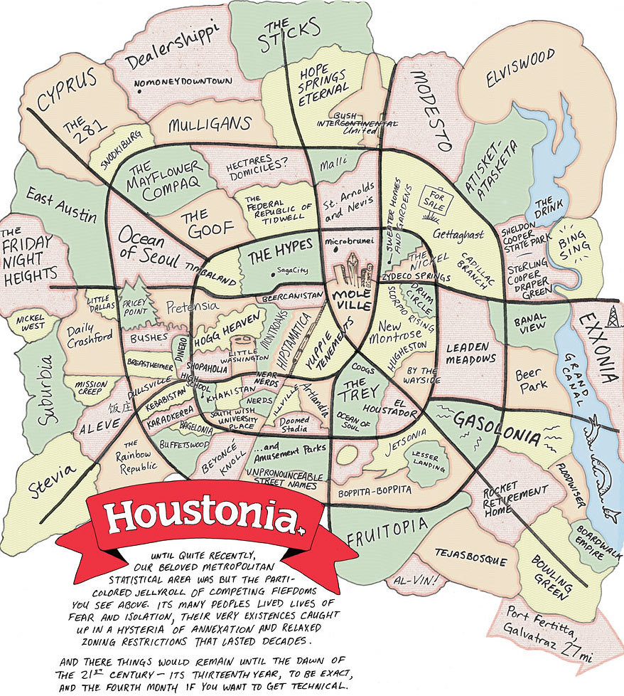
This is a Houston that no one’s ever seen: The lines in the swamp have been drawn for new monthly magazine Houstonia’s inaugural issue, which landed on newsstands last Thursday. This map’s “competing fiefdoms” suggest what’s really happening here: Those of you north of I-10 are now making a home in “The Hypes.” And that up-and-coming former industrial wasteland east of Downtown’s been dubbed “New Montrose.” West of the Galleria? That’s “Breastheimer.” South of I-10 near Memorial Park and the Loop is “Hogg Heaven” and “Pretensia,” just east, of course, of the mansions in “Pricey Point.” And Midtown’s been divided by the light rail, split into West “Hipstamatica” and East “Yuppie Tenements.”
- Fiefs to Watch Out For [Houstonia]
- Previously on Swamplot: Heights Blvd. House of Houstonia
Drawing: Dan Derozier

Where’s all the new office space in Houston? Here, reports Metrostudy’s David Jarvis. The lemming-like red dots cramming together on the Beltway and Katy Fwy. out toward the Grand Parkway denote locations that are already under construction, totaling 12.5 million square feet of new office space. The green dots denote planned locations that would add 6 million more. The ExxonMobil campus up near the Woodlands, reports Jarvis, accounts for almost half of the new construction.
- Boom in office construction [Metrostudy]
- Previously on Swamplot: Welcome to the Land of ExxonMobil: A Tour of the Company’s New North Houston Campus
Map: Metro Study Report

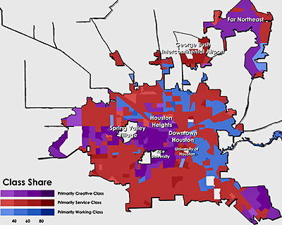
This map from Rise of the Creative Class author Richard Florida’s series at The Atlantic on “class-divided cities” shows where Houston’s working, service, and creative classes live.
Denoted here in purple, what Florida considers the creative class — that is, he writes, “people who work in science and technology, business and management, arts and culture, media and entertainment, and law and healthcare professions” — makes up 33 percent of Houston’s workers; that’s just a little bit larger than the national average, according to Florida, of 32.6 percent.
And what about the service and working classes?
COMMENT OF THE DAY: DELINEATING THE HOUSTON-KATY BORDER DMZ “I always thought George Bush Park was an appropriate boundary between what should be called ‘Houston’ and what should be called ‘Katy.’ However, this requires suffering a weird ‘interzone’ considering the feeder roads and Park Ten. Still, Park Ten has a feel of neutrality to it. Might still work.” [Katied, commenting on A Peek Inside Houston’s New J. Crew No. 2]
COMMENT OF THE DAY: WESTERN AIR “. . . in cities old enough to predate water systems it was common for the favored side to grow upstream. Even after city sanitation, flood control, and car ownership that makes it possible to live ‘way up a hill without having to have the leisure to live so far from things – and even where that legacy doesn’t hold over in property investment – air quality is generally better higher up, nevermind views: so that in North America, where our water often flows to the east and south, even newer cities often favor west and north. Especially north. Nashville, Monterrey, East Bay, Memphis, and others where the east or south is higher ground, or cities where race riots took place after city sanitation came around, prove the rule by suggesting how much it takes to buck it and confirming why. Think about it and see why else you can come up with!” [Austin, commenting on Comment of the Day: The Common Divide]
COMMENT OF THE DAY: THE COMMON DIVIDE “. . . regarding the splitting of houston into east/west, is there any city in the US where the east side has higher average incomes and more infrastructure spending? seems that with most every city i can think of the east side is generally much more destitute than the west.” [joel, commenting on This Week, Houston Begins Slicing What’s Left of the Katy Prairie in Two]
LOOKING FOR HOUSTON ON THE MUSIC MAP “The amazing thing about Houston is that geographically it’s located at the southernmost end of the blues belt, the westernmost part of the Cajun music culture and northernmost part of Norteño musical culture.” — Former Blaster and X guitarist Dave Alvin [Houston Press]

