THE HOUSTON HURRICANE POLLUTION-SNIFFING NASA FLIGHT THAT NEVER TOOK OFF  A week and a half after Hurricane Harvey hit Houston, as damage to smokestacks, pipelines, and chemical storage tanks were still being assessed, flooded Superfund sites went unmonitored, and clouds of benzene and other chemicals assembled in the skies over the city, the crew of a California-based airborne NASA chemical lab offered to help figure out the state of affairs — by diverting its specially equipped DC-8 from a planned trip to Oklahoma to take measurements in Houston instead. But EPA and TCEQ officials vehemently passed on the offer. An email response from TCEQ air toxicologist Michael Honeycutt noted that “state data showed no sign for concern,” report the L.A. Times‘s Susanne Rust and Louis Sahagun. “We don’t think your data would be useful for source identification while industry continues to restart their operations,” wrote Honeycutt, who the following month was appointed to head the EPA’s Science Advisory Board by President Trump. David Gray, the EPA official in charge of the Harvey emergency response, agreed. Citing emails from Texas officials “stating unambiguously that they do not want NASA to use the DC-8 for any data acquisition,” Michael Freilich, the director of NASA’s Earth Sciences division, called off the mission. [L.A. Times] Photo of Atmospheric Tomography Mission DC-8 interior, September 2017: NASA
Sign up for the Newsletter
Tag: Air Pollution

The U.S. Chemical Safety Board’s animated video (above) on the explosions at the Arkema Chemical Plant in Crosby recounts the steps taken by the brave workers stuck in charge of the facility in the aftermath of Hurricane Harvey. But a few angles less charitable to the company’s emergency planning effort aren’t included — possibly because they’d be a little more involved to animate. For example, the noxious fumes that emanated from the first fire, on the night of August 31, which according to a lawsuit filed later Arkema gave no warning about — and sent 23 people to the hospital, many of them vomiting and gasping for cleaner air.
And another detail: The remote detonations of 6 trailers containing unrefrigerated organic peroxides were carried out by the Houston Police Department’s bomb squad. “The entire police operation was conducted without warning the public,” write the Houston Chronicle‘s Matt Dempsey and Jacob Carpenter. “Until the documents were released earlier this month by the EPA, the public didn’t know who performed the controlled burn, or how it was done.”
Reefer Madness

SOMETHING POWERFUL IN THE CROSBY AIR  This vivid description is included in the original petition of a lawsuit filed today against Arkema, operators of the chemical plant off the Beaumont Hwy. in Crosby — by 7 first responders injured after incidents there last week: “In the early morning hours of August 31, 2017, the first of several explosions occurred as a result of the abandoned chemicals heating up and igniting. Although the explosions had occurred, no one from Arkema alerted the first responders who were manning the perimeter of the arbitrary mandatory evacuation area. Immediately upon being exposed to the fumes from the explosion. and one by one. the police officers and first responders began to fall ill in the middle of the road. Calls for medics were made, but still no one from Arkema warned of the toxic fumes in the air. Emergency medical personnel arrived on scene. and even before exiting their vehicle, they became overcome by the fumes as well. The scene was nothing less than chaos. Police officers were doubled over vomiting, unable to breathe. Medical personnel, in their attempts to provide assistance to the officers became overwhelmed and they too began to vomit and gasp for air. Some of the police officers. unable to abandon their vehicles due to their weapons being present, jumped in their vehicles and drove themselves to the nearest hospital. The other officers and medical personnel were all placed in an ambulance, and were driven to the hospital.†[Houston Chronicle; International Business Times] Still image of smoke from fire after Thursday’s explosion: abc13

COMING OFF THE STATE WATCHLIST DOESN’T MEAN HOUSTON’S POLLUTION HOTSPOTS DON’T STILL NEED TO BE WATCHED 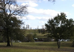 Of the 14 sites pulled off the Texas Commission for Environmental Quality’s special pollution watchlist since 2007, Elena Craft writes in the Chronicle’s Gray Matters column today, some 8 of them have since had new noteworthy upticks of various chemicals linked to health issues like breathing problems, nerve problems, or cancer, according to the Environmental Defense Fund’s recent study. Craft dives into some of the sticky aspects of trying to keep track of whether chemical levels are above normal for visitors and residents near spots like Milby Park (above) and the Lynchburg Ferry area, including the fact that the data collected by on-site monitors isn’t always available to the public right away, and that short-term high levels of problem chemicals don’t usually get investigated. “The absence of information about these seemingly random pollution spikes is troubling,” Craft writes, “because it suggests that TCEQ has stopped paying attention before its work is truly complete.” [Houston Chronicle; previously on Swamplot] Photo of Milby Park: Ric F.

The fire that started late yesterday afternoon at the Holmes Road Recycling Center (just west of 288 south of 610) is still on the Houston Fire Department’s list of active incidents at the moment, after about 19 hours.  KHOU reports that the firefighting has been complicated by the need to cool off the heat-retaining piles of burning scrap metal on the scene, as well as a lack of water supply in the industrial patchwork around Pierce Junction. Hazmat crews reportedly say there’s no out-of-the-ordinary chemical concerns related to the smoke this time, though HFD captain Ruy Lozana did note to KHOU last night that the smoke’s strong smell and darker color is probably from leftover fluids in crushed cars catching fire.
Wind coming primarily from the south and southeast pushed smoke and haze from the fire across 610 all the way to the Texas Medical Center, some 3 miles north. Nearby Rice University sent out an alert around 4:45 warning folks with respiratory issues to stay indoors for a bit — below is a view (from several hours after that warning) of the haze from the Rice campus parking lot on Greenbriar, east of the stadium:
Blowing In the Wind

WHAT’S SO SPECIAL ABOUT THE PASADENA REFINERY THAT RELEASED 3 MORE TONS OF AIR POLLUTION ON THURSDAY?  “We worry about this plant more than we worry about the others,” Air Alliance Houston director Adrian Shelley tells Dylan Baddour after last week’s release of a 6,000-pound cocktail of toxic air contaminants from the Pasadena Refinery System complex, south of Buffalo Bayou just east of the Washburn Tunnel. The release occurred in the wake of a 7-hour power outage at the Petrobras-owned refinery (which played a role in the massive Brazilian corruption scandal that came to light last year); Baddour says this is the 8th contaminant release the company has reported so far this year (and the 65th since 2005). Shelley notes that the plant has a reputation for “large particulate matter (soot) release events that you really don’t see at other Houston refineries,” including the 2 tons of soot released on Thursday with sulfur dioxide gas and other contaminants; Shelley also notes that one of the plant’s key federal permits expired last year, resulting in a $7000 fine from the TCEQ. [Houston Chronicle; previously on Swamplot] Photo of Pasadena Refinery Systems, Inc. plant at 111 Red Bluff Rd.: Center for Land Use Interpretation (license)

MAPPING URBAN METHANE LEAKS BY DRIVING GOOGLE’S STREETVIEW CARS THROUGH THEM Meanwhile, in Los Angeles: Researchers are teaming up with Google to outfit Streetview camera vehicles with sensors to detect methane gas leaks in urban settings. The project, coordinated by the Environmental Defense Fund, found an average of 1 leak per every 4 miles driven around Pasadena, CA, and 1 leak per 5 miles in Chino and Inglewood. Drives through Boston and Staten Island registered as many as 1 leak per mile. The project is expanding to map more cities; no maps of Texas or Gulf Coast cities have yet been published. Researchers connected to the mapping initiative have also turned similar methane sensors on the neighborhood near the ongoing methane plume in Aliso Canyon, which has been uncontrollably leaking thousands of tons of natural gas since late October. [EDF via 538; Atlas Obscura]
COMMENT OF THE DAY: FOLLOW THE SMOG 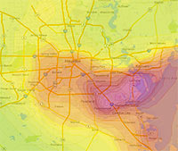 “You do not escape smog in Houston by moving to the burbs. In the summer, Houston has a circular wind pattern that takes ship channel pollutants for a ride out to the suburbs. Go to the Houston Clean Air Network website and set the animation for Aug. 6, 2012. You will see a big area of ozone form over the ship channel that gets blown out to Pearland, then Sugar Land and spends the late afternoon in Cinco Ranch and just east of Katy before starting to drift back east. The worst of the smog slides south of the City and never really gets north of I-10 inside the loop. Ship channel industries account for about 2/3rds of the smog. The rest is motor vehicle emissions. Ship channel industries have made significant progress in reducing and controlling emissions. But more sprawl and more traffic threaten to offset the progress made on the ship channel. Thus, the smog issue is a very real consequence of sprawl that is not escaped by sprawl either.” [Old School, commenting on Holding Back on That Downtown Hotel Push; The Beer Garden, Greenhouse, and Food Court Growing in Prohibition’s Basement] Image: Houston Clean Air Network

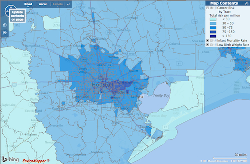
How do you feel about Houston’s airborne cancer hotspots? That’s easy! Just pick up a copy of the latest issue of Cite magazine and run your fingers over the top of it: Cite 93‘s front cover has been embossed with a map diagramming the area’s cancer risk. The places where airborne toxins mapped by the EPA are most prevalent are in the pits.
The mapped information here isn’t exactly fresh — it’s from the 2005 National-Scale Air Toxics Assessment, and the data only account for airborne known-cancer-causing toxins that are tracked by the EPA. Though it’s posted online, the map version isn’t exactly easy to find. But bravely thumbing his nose at Houston’s proud and longstanding tradition of hush-hushing location-based cancer hazards, Cite editor Raj Mankad gives Swamplot readers the secret recipe for finding the browsable map:
Air Toxics, Online

W. A. PARISH PLANT ONE OF THE WORST POLLUTERS IN THE COUNTRY, FINDS REPORT  According to a new study published by Environment America, NRG Energy’s coal-firing W. A. Parish Electric Generating Plant, on Smithers Lake outside of Richmond, is really good at being dirty. Though the plant has been messing around with a way to clean itself up in the past year or so, the report, published today, still fingers it as the 5th dirtiest in the country when it comes to carbon emissions. And here, in order, are 1-4: “Georgia Power Co.’s Plant Scherer, Alabama Power Co.’s James H. Miller Jr. Plant, Luminant’s Martin Lake in Texas, [and] Ameren’s Labadie in Missouri.” [StateImpact; Environment America; previously on Swamplot] Photo: Flickr user Joe A.

STUDYING HOUSTON’S ROADSIDE AIR QUALITY  Another source of Houston’s pollution has got the attention of the Texas Commission on Environmental Quality: tailpipes. Starting in January, the agency will place a pair of monitors within 160 ft. of 2 our most heavily used roads — including the Southwest Fwy. near the Westpark Tollway — to record the amount of nitrogen dioxide leaked into the air. Apparently, the stuff can be pretty nasty, writes the Houston Chronicle’s Matthew Tresaugue: “The Environmental Protection Agency said studies have measured concentrations of the gas to be as much as 100 times greater near major roadways than away from them. Scientists, meanwhile, have linked the pollutant to asthma and other lung ailments, especially among children and the elderly.” The results of these monitors, adds Tresaugue, might lead the city to make decisions about preventing schools and residences from being built in and around affected areas. [Houston Chronicle ($); previously on Swamplot] Photo: AA Roads

HOW HOUSTON’S AIR GOT BETTER  During the past decade, Houston’s notoriously polluted air has become — well, if not quite good, then not quite as bad, says NPR’s Richard Harris. (Pay no attention to what that ozone app may or may not tell you.) How? Well, it seems that pollution regulators in the early aughts had been worrying about all the wrong gases: “They were going all-in against [only] one of the pollutants that create smog, while downplaying the role of other emissions from the petrochemical plants,” reports Harris. “Barges carting chemicals up and down the [Ship Channel] were leaking. . . . And some types of storage tanks were leaking as well. . . . It turns out that routine day-to-day emissions were not the biggest problem.” Since then, regulations targeting those chemicals, like ethylene — as well as the use of infrared cameras that can spot them — appear to have made a difference: Port of Houston Authority employee Dana Blume tells Harris: “I can look out of my office window now and almost every single day see downtown.” [NPR; previously on Swamplot] Photo: Flickr user stmu_mike

NOW ON YOUR MOBILE DEVICE: WHY YOU CAN’T BREATHE  A team comprising researchers at UH, Air Alliance Houston, and the American Lung Association have launched OzoneMap, an app that “monitors chemical weather,” reports John Metcalfe of The Atlantic blog Cities. And whether the app helps explain your coughing fit or alerts you to the chance of a really pretty toxic sunset, the best part is that it’s only available in Houston! And why Houston, of all places? Besides the industrial flares, that is? Here’s Metcalfe: “The Houston/Baytown/Huntsville region comes in eighth place for most ozone-polluted cities in America, as ranked by the American Lung Association. Persistently sunny weather, a battalion of petrochemical facilities and scads of fuming cars on the road make Houston a nightmare for anyone who’s chemically sensitive. For these folks, walking outside is like playing a lower-stakes version of Russian roulette, with 30 to 40 days of the year fogged with hazardous levels of ozone.” [Cities; previously on Swamplot] Map: Cities


A new study from the National Center for Atmospheric Research documents how Houston’s vast expanse of paved surfaces allows the city to hold onto locally developed air pollution for longer periods of time, and prevents breezes that would otherwise naturally develop from sending all that nasty smog and stuff to outlying areas. Concrete and asphalt paving helps by soaking up heat during the daytime. This keeps land areas relatively warm overnight, which means there’s a lower contrast between land and sea temperatures during the summer. The result? Much less of those smog-stealing nighttime summer breezes. During the daytime, Houston buildings help to block local winds and keep things more still in the afternoon. Just another way standard development practices allow Houston to be a responsible steward of its own locally produced airborne products.

THE LUNCHTIME RACKET AT BRADY’S LANDING Visiting the Houston Ship Channel on a promotional “toxic tour” of sites where the air will likely be invigorated once nearby refineries get chugging on the Canadian tar sands headed for Houston through the proposed Keystone XL pipeline, Perry Dorrell stops by the scenic Brady’s Landing Restaurant during lunchtime: “During the evening the restaurant is like many others in the city: bustling with patrons and staff, the parking lot busy with diner traffic. During the day, however, the region’s oppressive noise is invasive and obnoxious; right next door a facility is dry-docking barges and a team of several men operating industrial-grade pressure washers removes barnacles from their hulls. Cranes swing containers to and from foreign freighters, crashing and booming. The warehouses directly across the channel are beehives of activity, with stevedores operating forklifts, shifting and stacking and slamming pallets of material. It was amazing how loud it was, a phenomenon I never noticed in my visits at night to dine. On the other side of the restaurant a steamshovel was loading and unloading a smoking, 200-hundred-foot high brown pile of … something, fertilizer-like in appearance. No accompanying aroma, fortunately. Maybe we were upwind.” [Brains and Eggs; previously on Swamplot]