WHEN GOOGLE MAPS REVEALS YOUR HOME’S SOGGY SHAME  “Google Maps has outed us as a city that floods,” laments meteorologist Brooks Garner, giving voice to would-be sellers of flooded homes worried that recent soggy aerial views will remain in the mapping system for years: “It should be said that legally, home owners must disclose if their home has ever flooded (or even if their property has flooded, while their actual house stayed dry). While that’s defeating enough to have to do, words are less influencing to a buyer’s decision than seeing an actual image of the inundated neighborhood. It arguably gives the impression that the water is still that high. . . . KHOU 11 has featured Realtors on our News at 4pm who’ve speculated that once people ‘forget’ about the floods, depressed home values in submerged areas will return to their pre-Harvey prices. (At least one realtor with that opinion was a victim of flooding himself, so I wonder if that fact influenced his statement.) . . . Here are several other ‘unfair’ things: Neighborhoods which experienced short-term flooding, but saw it subside after a day or two, were largely missed by the Google satellite update. They look high and dry. The only ‘tell’ in some is the trash which is piled high along the sidewalks. Drywall, couches, mattresses and furniture making up these walls of debris. It’s so extensive in places like Meyerland you can see [it] from space. In other areas like Hall Rd. off Beamer in southeast Houston, the satellite-update at time of this blog’s publishing apparently ‘missed’ the neighborhood and as a result, things look totally normal despite the huge mounds of refuse still present today.” [KHOU] Screenshot of Cinco Ranch on Google Maps: KHOU
Sign up for the Newsletter
Tag: Online Resources

The Galveston District of the U.S. Army Corps of Engineers has made public a set of interactive maps — normally used by emergency personnel — that show which areas along the length of Buffalo Bayou are predicted to remain under water or emerge from it as officials continue to release water from the Addicks and Barker reservoirs upstream. Individual interactive map panels cover each day from September 5th through the 16th, but as of this date all rely on data developed on Tuesday, when the maps were created.
The embedded version above mimics the view from a mobile browser; you can zoom in to view the projected water line on any street. To switch days, click on one side or the other of the panel at the bottom of the frame — or choose the date directly from the menu that appears after you click on the icon in the top left corner.
To view the map in its own browser window, click here.
- Addicks and Barker Projected Inundation Levels [USACE Galveston]
- Know How High the River Flows [Save Buffalo Bayou]
Inundation Levels, Day by Day

The Houston Association of Realtors’ promised Harvey temporary housing mini-site went live yesterday. Unlike HAR’s main site of MLS listings, the new Harvey site allows anyone to post available properties — or at least to attempt to do so; each one must be approved before it is posted.
The association with Hurricane Harvey relief efforts provides a charitable aura to the site, but that may or may not be reflected in the by-the-week rental listings that show up: There’s no requirement that rents on listed properties be reduced — or not elevated over expected levels. You can sign up to post a property here. They can go up for a week at a time or for up to 90 days.
We’ve embedded a portion of the site above so you can get a quick sense of the locations and pricing of the listings that have populated it already, but the main site is more functional — it includes a sidebar you can use to filter results or show detail on individual properties.
Prior to Harvey’s arrival, Airbnb suggested to property owners that they might want to offer their homes as shelters to those fleeing the storm at little or no cost. The company waived its service fees for the homes, and provided a section of its website to list them.
- Harvey Temporary Housing [HAR]
- Urgent Accommodations [Airbnb]
Weekly Rates

If you or someone you’re helping has been accepted into FEMA’s Transitional Shelter Assistance program — meant to clear out shelters by providing people who can’t return to their homes a hotel or motel room for a limited period of time — you may want to use the map shown here. It marks the locations of every eligible hotel or motel in the Houston area approved by the program. Using the map should make it easier to find an acceptable one nearby. To view the map in its own browser window, click here.
This map is yet another whipped-up-by-volunteers-in-a-jiffy product of Sketch City — this one created by the civic hacking group’s founder, Jeff Reichman. Sketch City volunteer and college sophomore Nile Dixon (who earlier created a similar tool to help people find nearby shelters) has created a simplified text-it-to-me version of it as well: Just text your ZIP Code to 832-981-4926 and a bot will send back contact info for the nearest verified accommodations in the program.
You can find out more about U.S. government Harvey assistance, including the TSA program, from the FEMA Harvey website.
- Map of FEMA-Approved Transitional Shelter Assistance Sites in the Houston Area [Sketch City]
- Texas Hurricane Harvey [FEMA]
- Sheltering And Immediate Assistance Available After Hurricane Harvey [DHS]
- Previously on Swamplot:Â How To Find Volunteers To Clear Out Your Flooded Home, and How To Volunteer To Help Clear Out Flooded Homes;Â The Best Way To Find Out Which Hurricane Harvey Shelters Near You Need Help, and What They Need;Â The Quickest Way To Find the Nearest Hurricane Harvey Shelter That Isn’t Already Full
Map: Sketch City
Harvey Maps

Here’s the latest publicly available high-resolution aerial imagery of Houston-area flooding, in an interactive map you can use to zoom in and examine in detail and by address. The imagery in the map above comes from the National Oceanic and Atmospheric Administration, and was taken this past Wednesday and Thursday, August 29th and 30th — as floodwaters subsided in many areas of the city but continued to build in a few parts west.
Included in the portions of the city photographed by NOAA: the sections of Memorial south of I-10, west of Gessner Rd., north of Briar Forest Dr. (that’s below Buffalo Bayou), and east of the Addicks and Barker reservoirs. That’s the area where Mayor Turner earlier today said residents who already have water in their homes should probably leave their homes now if they haven’t already — because water is likely to remain in them for the next 10 to 15 days as releases from the dams continue.
To zoom in on the latest aerial imagery from that area, you can click on the search box in the map above and type “Memorial, Houston,” then click on the first option that appears below where you’re typing. Then zoom in further to see where the floodwaters are and aren’t. You can identify the date of the imagery and turn on and off various layers if you click on the lower of the 2 icons on the top right of the map. To view the map larger in your browser window, navigate directly to NOAA’s Harvey site.
Harvey Flooding from Above

This just-launched map tool from civic-minded hacking co-op Sketch City is meant to help homeowners who could use help clearing out soggy carpet and other materials from their flooded homes connect with people willing to volunteer their time and effort to help with that work. It’s called the Texas Muck Map — muck being a useful term in Houston these days. Mucking, in this context (and context truly is everything), means removing carpet or flooring, stripping drywall that was exposed to moisture and is at risk of growing mold, clearing out dirt, furniture, and other junk, and generally getting a flooded home ready to dry out.
Harvey has made sure a lot of homes around these parts will need mucking — over the next several weeks at least. Is that work you or someone you’re helping needs doing? Or work you or people you know are able to help with? The map above identifies the locations of homes people have added to it that need mucking — and the approximate locations of would-be volunteer mucker teams or individuals. (The map might appear sparsely populated now, but if you spread word about it it’s likely to fill up quickly.) Click on any of the icons to see details and contact info, which you can use to make your own connections.
To add your ready-to-be-mucked home to the map, click here and fill out the form. If you’d like to volunteer to muck homes, click here and fill out the form. To see the map in its own browser window, click here, or just go to muckmap.harveyneeds.org. Also on that site: some guidelines for using the map, a disclaimer, and links to several helpful resources about mucking and related issues.
A Harvey Muck Map

Here’s another helpful online tool from the civic hackers at Sketch City, this one for would-be volunteers: a crowdsourced, interactive map showing which shelters near you are in need of what resources — and which ones might need people to come over and help out. Each icon on the map represents a shelter or providing organization that’s helping evacuees who’ve been put out of their homes by Harvey flooding. Click on one and a panel on the left will indicate any supply needs or volunteer needs identified by the site. (A larger, full-browser-width version of the map is here.)
The map was put together by Amanda Shih, Dr. Neeraj Tandon, and Chris Ertel, and is linked to data assembled and continually updated by a group of dozens of local and not-so-local volunteers hooked up to the project by Sketch City, a Houston nonprofit technology group. (The same bank of is behind Sketch City’s other new mapping project — one that simply identifies available Harvey shelters to people seeking them.) The volunteers have been making regular phone calls to update the information in a shared Google Doc. (If that kind of call-and-type-from-home work is your preferred method of volunteering, go ahead — you’ll find a direct link to the underlying spreadsheet in the map.)
- Harvey Needs [Sketch City on Github]
- Previously on Swamplot: The Quickest Way To Find the Nearest Hurricane Harvey Shelter That Isn’t Already Full
How and Where To Volunteer

Here’s a crowdsourced, interactive map showing more than 180 shelters and shelter-ish locations set up in the last few days to take in evacuees separated from soggy homes as a result of Harvey flooding. Most of the indicated locations are in the Houston area, but others farther afield have been added (and are welcome) as well.
To use the map, you’ll first want to click on the icon just below the top left corner to toggle off the legend. Then you can zoom in or out or pan around, and click directly on each location to read details — such as the address, phone number, whether there’s room for more people, and how recently the information has been updated. You can access a larger version of the map directly by going to houstonsheltermap.com.
If the map provides more info than you need right now, there’s an easier way to find the closest shelter to you that’s still accepting newcomers: Just text your Zip Code (the one where you are; it doesn’t have to be your home address) to 346-214-0739. It’s set up to text you back the location of the nearest open hurricane shelter.
Data Rescue Ops


The newly opened stationary location of former food truck Pi Pizza got a huge boost in business this weekend after pro-gun-carry groups began leaving hundreds of negative online reviews of the restaurant, Eric Sandler reports this morning. Owner Anthony Calleo tells Sandler that Pi’s sales at the strip center spot south of I-10 where Funky Chicken used to roost were up nearly 20 percent on Saturday and 40 percent on Sunday.
What exactly triggered waves of gun activists (and counter-protesting pizza-supporters) to take to the restaurant’s Facebook and Yelp pages en masse? A casually dismissive and — sure — less-than-completely-diplomatic response to an initial 1-star review of the restaurant, by a user who had never visited, based solely on Pi’s decision to opt out of open and concealed carry. Sandler notes that Pi’s Facebook review page has been temporarily taken down, as the hundreds of negative reviews (and even larger numbers of positive comments and counterreviews, at least some of which also appear to be from people who have never visited the restaurant) eventually escalated to public searches for Calleo’s home address by some of the more enthusiastic pro-carriers; the pizza joint’s Yelp page was still in lockdown as of this afternoon.
Booming on Heights Blvd.

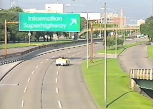
Sure, you might vaguely recognize the Houston street scene shown above, but maybe you’re unclear about what kind of modem you need to make the hard right turn from Memorial Dr. onto the information superhighway? “Maybe you’ve read or heard about the internet, but you’re still not exactly sure what it is? Well if that’s the case, don’t worry. In no time at all you’ll be able to impress everyone with your amazing techno-savvy.” Just by watching this hour-long 1995 PBS program sponsored by Compaq (and Viewers Like You) all about this crazy new Internet thing:
Houston in the Early Internet Era

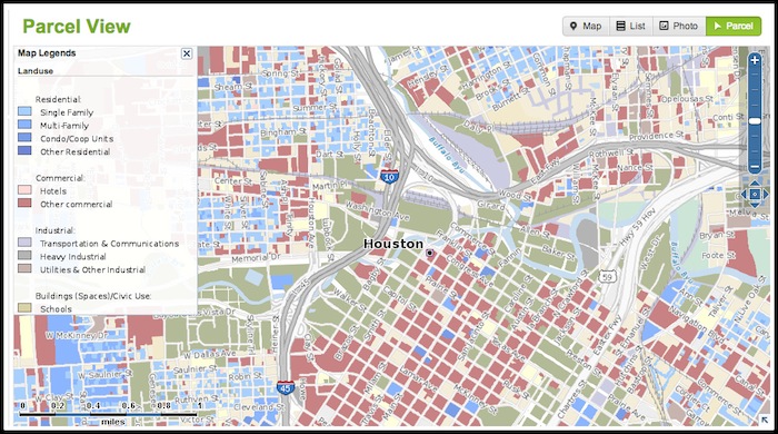
NUHABITAT’S ASKING-PRICE HISTORIES ARE BACK IN ACTION ![]() Home listing sleuths who’d been relying on historical asking-price data from NuHabitat (when most other consumer-facing MLS sources keep that info hidden) will be relieved to hear that the feature has been restored. Company founder Jeff Burke tells Swamplot the disappearance of the data from NuHabitat’s Price Tracker, which users began noticing last week, was inadvertent; an update pushed out earlier today brings it back. For logged-in users (only), NuHabitat’s Price Tracker provides histories of sales prices as well as details of former asking prices for properties currently on the market, in most cases even if they’ve been yanked over to a new MLS number. (Click on the dollar-sign logo underneath a property listing to see it; the screenshot above shows data for this Cambridge Green property featured on Swamplot last week.) A better dashboard for tagging and setting up alerts on multiple properties should be available to consumer users within a week or so, says Burke, following improvements in the “swipeability” of property images on mobile devices, which went live last month. [NuHabitat; previously on Swamplot]
Home listing sleuths who’d been relying on historical asking-price data from NuHabitat (when most other consumer-facing MLS sources keep that info hidden) will be relieved to hear that the feature has been restored. Company founder Jeff Burke tells Swamplot the disappearance of the data from NuHabitat’s Price Tracker, which users began noticing last week, was inadvertent; an update pushed out earlier today brings it back. For logged-in users (only), NuHabitat’s Price Tracker provides histories of sales prices as well as details of former asking prices for properties currently on the market, in most cases even if they’ve been yanked over to a new MLS number. (Click on the dollar-sign logo underneath a property listing to see it; the screenshot above shows data for this Cambridge Green property featured on Swamplot last week.) A better dashboard for tagging and setting up alerts on multiple properties should be available to consumer users within a week or so, says Burke, following improvements in the “swipeability” of property images on mobile devices, which went live last month. [NuHabitat; previously on Swamplot]


Why are so many of the men featured in the Tinder Guys Posing with Art Tumblr posing with art that’s in Houston? Maybe it’s because the website’s creator and curator, Sally Glass, is based here. Scroll through the entries Glass has been posting since April and you’ll not only find available men on Tinder who’ve staked out positions in and around some of the city’s more prominent sculptures and paintings, you’ll also find a handy guide to the works they favor:
Local Screenshots

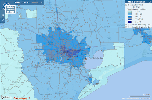
How do you feel about Houston’s airborne cancer hotspots? That’s easy! Just pick up a copy of the latest issue of Cite magazine and run your fingers over the top of it: Cite 93‘s front cover has been embossed with a map diagramming the area’s cancer risk. The places where airborne toxins mapped by the EPA are most prevalent are in the pits.
The mapped information here isn’t exactly fresh — it’s from the 2005 National-Scale Air Toxics Assessment, and the data only account for airborne known-cancer-causing toxins that are tracked by the EPA. Though it’s posted online, the map version isn’t exactly easy to find. But bravely thumbing his nose at Houston’s proud and longstanding tradition of hush-hushing location-based cancer hazards, Cite editor Raj Mankad gives Swamplot readers the secret recipe for finding the browsable map:
Air Toxics, Online


According to a recent study by the National Association of Realtors, 90% of homebuyers search online and shoppers perform an average of 11 searches before taking action on a real estate site. In addition to sites like Zillow and Trulia, Point2 Homes is a site you should consider when doing your Houston searching. It’s got some features that can have you staring at the computer late into the evening.
Sponsored Post

CALCULATING THE GREEN FOR THIS WEEKEND’S FREE TREE GIVEAWAY  Hmmmm . . . what’ll it be for your yard? Live Oak, Bald Cypress, Burr Oak, Cedar Elm, Chinkapin Oak, Drummond’s Maple, Loblolly Pine, Mexican White Oak, Nuttall Oak, Overcup Oak, Pecan, Shumard Oak or Water Oak? Come to the remote Rodeo Houston parking lot at 2030 Reed Rd. with your electric bill in hand this Saturday, October 26, between 8:30 and 3:30 and you’ll have your pick — of whatever’s left. Trees for Houston, CenterPoint Energy, and the Arbor Day Foundation will be giving away a total of 2,500 specimens in 5-gallon containers this weekend (a couple thou are still unclaimed). You can reserve yours online. A handy satellite-photo-equipped web app is meant to help you decide where to plant your tree and which species to plant; it estimates annual energy-cost savings for each type of tree, depending on where you place it on your property. [Arbor Day Foundation]
