COMMENT OF THE DAY: THE DELMAN THEATER LIVES ON, ON GOOGLE MAPS  “If you look at Google Maps satellite view, you can still see the patterned terrazzo floor of the theater.” [Benjy Compson, commenting on How the Marriage of Richmond and Wheeler Came Too Late to the Midtown Sears Building’s South Side]
Sign up for the Newsletter
Tag: Google Maps

WHEN GOOGLE MAPS REVEALS YOUR HOME’S SOGGY SHAME  “Google Maps has outed us as a city that floods,” laments meteorologist Brooks Garner, giving voice to would-be sellers of flooded homes worried that recent soggy aerial views will remain in the mapping system for years: “It should be said that legally, home owners must disclose if their home has ever flooded (or even if their property has flooded, while their actual house stayed dry). While that’s defeating enough to have to do, words are less influencing to a buyer’s decision than seeing an actual image of the inundated neighborhood. It arguably gives the impression that the water is still that high. . . . KHOU 11 has featured Realtors on our News at 4pm who’ve speculated that once people ‘forget’ about the floods, depressed home values in submerged areas will return to their pre-Harvey prices. (At least one realtor with that opinion was a victim of flooding himself, so I wonder if that fact influenced his statement.) . . . Here are several other ‘unfair’ things: Neighborhoods which experienced short-term flooding, but saw it subside after a day or two, were largely missed by the Google satellite update. They look high and dry. The only ‘tell’ in some is the trash which is piled high along the sidewalks. Drywall, couches, mattresses and furniture making up these walls of debris. It’s so extensive in places like Meyerland you can see [it] from space. In other areas like Hall Rd. off Beamer in southeast Houston, the satellite-update at time of this blog’s publishing apparently ‘missed’ the neighborhood and as a result, things look totally normal despite the huge mounds of refuse still present today.” [KHOU] Screenshot of Cinco Ranch on Google Maps: KHOU

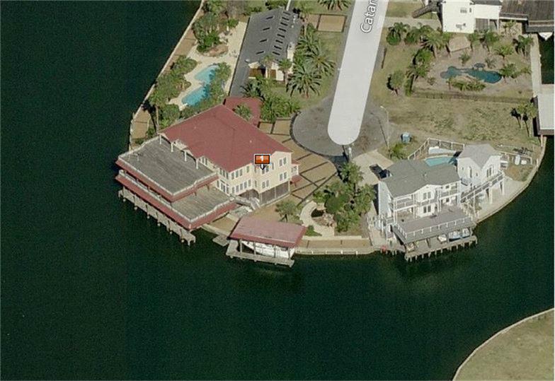
- 202 Catamaran Dr. [HAR]

DOCUMENTING HOUSTON’S TOWNHOUSIFICATION, ONE TWEET AT A TIME 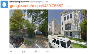 While you’re waiting for Kuukibot’s polite but insistent stream of air toxics tweets to come back, another Houston-obsessed account has just hit the Twittersphere — this one documenting the city’s infill development, as evidenced by daily before-and-after shots pulled from Google Streetview (like the 2-house-t0-7-townhome transition shown above, from near the intersection of Gibson and Snover streets in Brunner).  The account’s Philadelphia-based author (who’s looking for submissions, by the way) points to the 1999 changes in minimum lot size requirements as the catalyst for the subsequent waves of tightly-packed townhouse do-overs in previously large-lot neighborhoods around town, as explained by Daniel Hertz earlier this summer: Hertz writes that  the decision to allow lots as small as 1,400 sq.ft. within the Inner Loop (a decree later expanded city-wide in 2013) allowed the building of way more housing stock in the city’s core without a switch to multifamily-style buildings. “An important research project in the coming years ,” Hertz notes, “will be to see if Houston’s willingness to allow more housing—and especially missing middle housing—in the center of a growing metropolitan area can reduce the growth of housing prices and keep neighborhoods more diverse and affordable than they would otherwise be.” [City Observatory] Screenshot of Densifying Houston tweet: @densifyingHOU

‘TAMPICO HEIGHTS’ IS NOW A THING ON GOOGLE MAPS 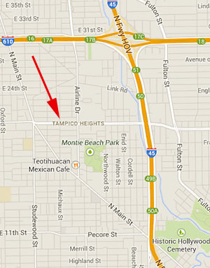 Near Northside residents who didn’t want their neighborhood to be called Tampico Heights have been successful in their campaign to keep the new name out. But it looks like Tampico Heights may be settling in as a new neighbor. A reader reports — and a quick online search confirms (see screen capture at left) — that Google Maps has now begun applying the new name Tampico Heights to area maps. Northside Village has been spared the Heights creep: The Tampico Heights name appears to have been applied to inner-loop neighborhoods Brooke Smith, East Sunset Heights, and portions of Sunset Heights west of I-45 and east of North Main, and not to Northside Village or the Near Northside, which lie east of I-45. That’s a more reasonable spot for a Tampico Heights to land anyway, since it incorporates the Tampico Refresqueria at 4520 N. Main St. and Tampico Seafood & Cocina Mexicana, at 2115 Airline Dr. [Previously on Swamplot]

")
It’s certainly not the first aircraft to show up in a Google Maps satellite view, but this Southwest Airlines Boeing 737 found lounging on Broken Bough St. just east of Gessner may be the first to be found through a real estate listing. A reader came across a portion of the airplane image in the HAR map view of this 1961 Memorial Forest Ranch listed for sale one street over. The home features 4 bedrooms, 2 baths, a den with fireplace and backyard view, and is conveniently located on the flight path to Hobby Airport.


If you’d ever noticed that Google’s Street View feature is completely blacked out in the northern part of River Oaks and just presumed that your inability to see online images of all those fancy houses in Tall Timbers had something to do with their residents’ wealth, access to lawyers, or private security services, your presumption is wrong — or so says the Chronicle‘s Dwight Silverman, after a Google spokesperson sets him straight. Apparently the River Oaks gap in the Street View map is “just an oversight” on Google’s part:
I asked Google spokesperson Deanna Yick about this, and after checking in with the Street View team, she said this part of River Oaks simply hasn’t been imaged yet. She said Google eventually plans to fill in all the gaps in Street View “as soon as possible”.
She also said Google’s Street View cars will take pictures on any public street, and whole neighborhoods or communities can’t opt out of the process. However, individuals “can ask for images of their house, car or themselves to be removed from Street View,” she said.
Swamplot first noted the Street View black hole north of San Felipe and west of Kirby in 2008. Since then, Google has added a loop of coverage on Willowick and Inwood. But to see street-level images of the rest of that area, you’ll need to drive, pedal, or walk through the neighborhood on your own.
- River Oaks is a black hole on Google Street View [TechBlog]
- Google Maps coverage [Swamplot]


Do you know the way from Cassoulet to Jalapeño Gefilte Fish? With this handy map, navigating your multiple-course progressive dinner-about-town should be no problem. It’s former Houston Press food critic Robb Walsh’s 100 favorite restaurant dishes in Houston, conveniently laid out on a navigable Google map by Press reader Kyle Nielsen. Yep, Fried Mojarra at Taqueria Jesus Maria (#95), Kubideh and Zereshk Polo at Kasra Persian Grill (#89), Frito Pie at the Rio Verde Taco Truck (#50), Chocolate-Peanut Butter Cake Ball at Coffee Groundz (#94) — they’re all here, glistening bits of fat and all. We’re counting 44 dishes inside the Loop, the rest in the great beyond. Not included on account of them being all over the place: the Whataburger Triple Meat, Triple Cheese with Bacon and Jalapeños (#59) and James Coney Island Chili (#80). Burp.
- Robb Walsh’s Top 100 Houston Dishes, Houston Press [Google Maps]
- Local Man Is a Genius; Plots All 100 of Robb Walsh’s Favorite Dishes on Google Maps [Eating Our Words]


Earlier this week, Google greatly expanded the areas covered by its Street View feature. The expansion means street views in areas way outside of Houston and its surrounding areas are now viewable from within Google Maps. In fact, Google’s new coverage map indicates that pretty much all of Texas (or at least areas near its major roads and highways) now has navigable street images available, excepting a few patches here and there and a couple of wide swaths of land near El Paso.
What about the rest of the country? Oh, there’s some expanded coverage out there too:


Google has rolled out another update to its Street View feature, this time allowing simultaneous views of a property from the air and the street — as shown in this view of a familiar Rice Village site. The button labeled “Street View” that used to sit at the top of most maps is gone. In its place: a character named Pegman who stands at the ready above the zoom slider on the left side of each map, and who narrates this video detailing the new Google Map features:

When the Street View feature was first introduced to Houston Google Maps about a year ago, it allowed viewers to follow street-level photos . . . mostly along major thoroughfares. In March, Google added street-level views of residential neighborhoods within a huge swath of West Houston and Pasadena . . . but the update still left out most areas inside the Loop.
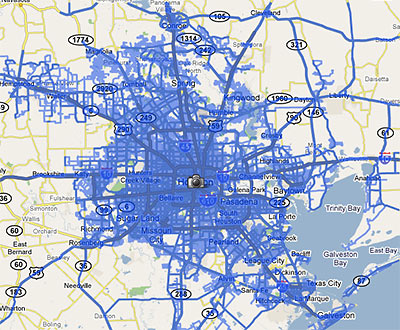
This week, a tipster informs us, Google has expanded Street View again, updating its database with photos taken from almost every street inside the Loop . . . and this time including most areas inside the Beltway and beyond as well. The map above shows the extent of the new coverage.
Smile! Photos of your home are likely now on the internet . . . unless you live in a few special areas in town . . .

Last week Google rolled out a major update of its Street View feature, adding 13 new cities and a national park, and expanding its coverage in 6 cities . . . including Houston. The map above shows the extent of the Houston street-level photos now available through Google Maps.
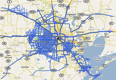
Previously, street views from Google Maps were available only from major thoroughfares in the Houston area. Now, they are available on just about every street . . . within the areas marked in blue. South Houston, plus areas west of 290 and 288 outside the Loop are now mapped street by street. But most inside-the-loop neighborhoods are still left out.
Strangely, this means Google Map addicts can stalk Cypress subdivisions virtually street by street, but views of Southampton are limited to sideways glances from Shepherd and Bissonnet.
After the jump: a sampling of the new street-level views of westside neighborhoods!
