THE STARVING ARTIST GALLERY IS GONE, BUT ITS PARTIES WILL LIVE ON ONLINE 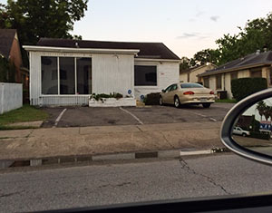 What kind of revelry has Montrose been missing since the end of April, when the Starving Artist Gallery at 2037 West Alabama St. closed up shop? No need to try to imagine, because owner William Loyd and his now legally recognized wife, Nikki Araguz Loyd, documented the mayhem at last year’s blow-out Christmas party at their gallery in the just-released final 2 pretty-much-NSFW episodes of the first season of their web video series, Nikki’s American Dream. They’re called “Bad Santa” (episode 7) and “It’s Only Wednesday” (episode 8). (The gallery maintains an online presence too.) [YouTube] Photo of former Starving Artist Gallery: Swamplot inbox
Sign up for the Newsletter
Tag: Streetlife

")
")
“People are always peeing on my street, so I bought a Q-Beam.” With that informative epigram, blogger Jay Rascoe takes his focus off his usual guns and tacos beat for a wee bit in his new Tumblelog, OneBlockOffWashington. There he catalogs his growing collection of caught-peeing, caught-puking, and caught-in-a-ditch videos shot from his home perch, which is, apparently, a block off Washington Ave. Rascoe’s frequent late-night interactions with would-be sidewalk urinators wandering back from club visits are frequently aided by the million candles’ worth of halogen in a pistol grip he points at perpetrators. But some of his most entertaining street-scene captures use only available light:


Organizer (and Free Press Houston editor) Omar Afra calls it:
This will be the last Westheimer Block Party. However, the next one will be the return of the Westheimer Street Festival. It may take 2 months or it may take 2 years but this festival has outgrown our singular capacity. There can only be a return of the Westheimer Street Festival. The streets must be shut down, the city must get behind the event, and I can no longer personally foot the bill. Our staff can no longer handle the capacity of the growing festival and squeezing all of these people into the same block is becoming hazardous. The streets must be shut down. We have an on camera commitment from Annise Parker, that if elected, she will support street closure if we can find financing for necessary portopotties, police, and clean up. She even shook my hand on it. But we need the community involved. So whoever is elected, we are asking for a big community turnout at the first city council open session the new mayor presides over. We need 500+ people to swamp city hall and show city officials that there is indeed a large constituency that supports arts and music. We will let you know when this transpires but we NEED your support. We love this community so much and want to see WestFest grow but it cannot in it’s current form. We will be forming a non-profit to meet this challenge which will be made up of only Jedi’s who have an unyielding love for arts and music. It is time to take BIG steps and we will do whatever it takes to shut down the streets. . . .
- The Last Westheimer Block Party [Free Press Houston]
Photo of Behind Buildings performing at last weekend’s Westheimer Block Party: Ramon Medina [license]

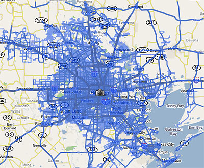
When the Street View feature was first introduced to Houston Google Maps about a year ago, it allowed viewers to follow street-level photos . . . mostly along major thoroughfares. In March, Google added street-level views of residential neighborhoods within a huge swath of West Houston and Pasadena . . . but the update still left out most areas inside the Loop.
This week, a tipster informs us, Google has expanded Street View again, updating its database with photos taken from almost every street inside the Loop . . . and this time including most areas inside the Beltway and beyond as well. The map above shows the extent of the new coverage.
Smile! Photos of your home are likely now on the internet . . . unless you live in a few special areas in town . . .
