01/11/19 2:45pm

Last night Houston’s planning and development department spelled out a proposal to run a new pair of protected bike lanes on Austin St. from Buffalo Bayou to HCC’s main campus in Midtown. South of the college, the officially-designated bike route would continue down to Hermann Park along La Branch and Crawford streets but without anything to buffer it from the rest of the road.

Throughout Downtown and the northern portion of Midtown ending at McGowen St., plans show the bike lanes separated from the street by 2-ft.:

CONTINUE READING THIS STORY

A Fairly Straightforward Route
01/02/19 2:00pm

And people say Houston’s bike lanes don’t get any use! The next time someone gives you that line, there’s no need to bicker. Instead, just invite them out for a beer at Saint Arnold’s new-ish brewing cathedral off I-10. On the way there, you’ll spot the new bike lanes running adjacent to the brewery on both sides of Lyons Ave. And if the conditions in the one on the eastbound side of the street are anything like those shown in the photo above, then congratulations: It should be clear who’s right.

If, however, parked car traffic appears sparse on the day you stop by, there’s only one possible reason why: New signs must have been installed, prohibiting parking in the bike lane. As long as no ordinance exists to ban bike lane parking outright, such signage is the city’s only recourse to outlaw it.

Further east along Lyons, work to add new 6-ft. bike lanes to both sides of the street is underway and — at Jensen Dr. — has already been completed:

CONTINUE READING THIS STORY

Free Parking in the Fifth Ward
12/13/18 4:30pm

COMMENT OF THE DAY: WHAT ELSE LEFT MIDTOWN WHEN RICHMOND AVE MET WHEELER ST. “In addition to the Delman Theater, an adjacent retailer named the Delman Juvenile Shop was also destroyed. The popular 1950s children’s clothing store featured a behemoth machine, the “Shoe-Fitting Fluoroscope,” that zapped the kids’ feet with unshielded x-rays, ostensibly to make sure the new shoes were a correct fit. In reality, it was used as a babysitter while Mom shopped. I couldn’t wait to grow tall enough to actually peer down the metal tube to view my wiggling skeletal toe bones.” [Patsy Schillaci, commenting on Comment of the Day: The Delman Theater Lives On, on Google Maps] Photo of Delman Theater and adjacent retail: Predator [license]

12/11/18 1:45pm

Anyone in the habit of leaving the house knows that Houston’s streets are really best appreciated from a distance. And although he’s not a native, Seattle artist Peter Gorman appears to agree. His recent work, “Intersections of Houston,” shown above, is a series of 20 mini-maps depicting some of the city’s most notably tangled roadway crossings. Some — like the nexus of Scott, Polk, York, and Clay streets (top row, second from the left) — take shape at the borders between Houston’s multiple, incongruous street grids. (The Allen brothers laid out the oldest grid parallel and perpendicular to Buffalo Bayou; later planners favored a more north-south orientation. In both cases, the resulting frameworks are some of the longest-lived legacies of the city. We’ve been stuck with them far longer than most of the buildings they contain.)

Others meander to get around park space: See Lamar, Crawford, and Dallas (third row, third from the left). And then there’s that special subset: intersections that do less to fit into their surroundings than they do to stand out as products of intrepid traffic engineering approaches. Take Lockwood Dr. and Wallisville Rd. (fourth row, third from the lift) for instance; it’s really just a claw-like take on a T-intersection.

CONTINUE READING THIS STORY

Left, Right, Left
12/07/18 2:45pm

Ever notice that the Wheeler-Ave. side of the Midtown Sears (shown above) doesn’t quite jibe with the rest of the building? It’s become even clearer since all that beige metal cladding was stripped off the structure earlier this year. Upon its removal, the biggest revelations were cascading green, red, and blue art-deco tile mosaics (shown here) running from top to bottom on every side of the building, except the Wheeler one, where the array of facade openings pictured at top are a bit less architecturally refined despite their prominent positions overlooking crosstown traffic.

So, what gives? Well, it turns out that Sears’s south side wasn’t all that visible when the building opened in 1939. Back then, Wheeler was just a narrow side street off Main and did not flow directly into Richmond as it does now, explains Preservation Houston’s Jim Parsons. Richmond, a much larger thoroughfare, also dead-ended into Main St., across from the Sears and just north of where Wheeler began. You can see the missed connection in the 1950 street map above.

It wasn’t until the early 1960s that the 2 streets were joined through a partial annexation of the Delman Theater property at 4412 Main, catty-corner southwest of the Sears:

CONTINUE READING THIS STORY

When Roads Collide
11/19/18 11:45am

WESTHEIMER WILL HENCEFORTH NOT BE CALLED UR 1093 ANYMORE, SAYS TXDOT Before last week, TxDOT had an obscure formal name for Westheimer Rd. on the books: UR 1093. The designation — short for “urban road” — was created 23 years ago to distinguish city thoroughfares from farm to market roads, reports the Chronicle‘s Dug Begley. But “No signs were ever erected,” he writes, “and it became clear no one was going to stop calling the roads what they always had, officials said in a written briefing for transportation commissioners. The only place the urban roads ever appeared was in the internal TxDOT roadway inventory.” There, Begley counts 30 Houston-area roads that were set to set to become URs “in theory, at least.” Officials killed the designation on November 15, reinstating Westheimer’s previous pseudonym FM 1093. The only thing that really changes: where funding for those roads can come from. Had the UR designation stuck, says a TxDOT spokeswoman, they would’ve been eligible for some extra federal maintenance money aimed at cities. [Houston Chronicle ($)] Photo of Westheimer Rd. at El Real Tex-Mex Cafe west of Yoakum Blvd.: Bill Barfield via Swamplot Flickr Pool

11/09/18 1:00pm

COMMENT OF THE DAY: SWAPPING OUT MEMORIAL DR.’S SPEEDWAY SETUP FOR SOMETHING WORTH WALKING Remove the freeway configuration of Memorial Dr. from Shepherd to Downtown. An urban street is all that is needed here since this mid-century design was prior to I-10 and was the original route for Katy-bound suburbanites. The bayou is now the destination — not a place to flee at break-neck speeds. Besides, the freeway configuration is useless as it ends prior to Memorial Park. The configuration has exceeded its useful life and is actually in very poor condition. Reasonable thought to an improved alternative is preferred and hopefully includes more park space.” [El Chico, commenting on Plucking the Cloverleafs off Waugh Dr. at Memorial So Extra Park Space Can Take Their Place] Illustration: Lulu

12/13/17 4:45pm

PETER H. BROWN, 1936–2017 Peter Brown, who passed away yesterday, wore many hats — he was an urban planner, architect, neighborhood activist, city council member, and occasional rapper — as well several distinctive long scarves. Amidst other civic legacies, he leaves behind a substantial back catalog of YouTube videos — in which an unseen cameraperson chronicles Brown’s peripatetic musings on various aspects of Houston’s occasionally urban landscape. As “Pedestrian Pete” on both a Facebook page and YouTube channel of the same name, Brown explored “the good, the bad, and the ugly pedestrian conditions of Houston”: He scoured neighborhoods in search of traversable sidewalks, railed against car-centric attributes of the Heights Walmart, and strolled along Lower Westheimer in conversation with Annise Parker, who had defeated him in his 2009 run for mayor. Brown was 81. [Houston Chronicle; previously on Swamplot] Video: Pedestrian Pete

12/13/17 4:15pm

COMMENT OF THE DAY: BROADACRES’ LONG HISTORY OF PUBLIC-PRIVATE PARTNERSHIPS 
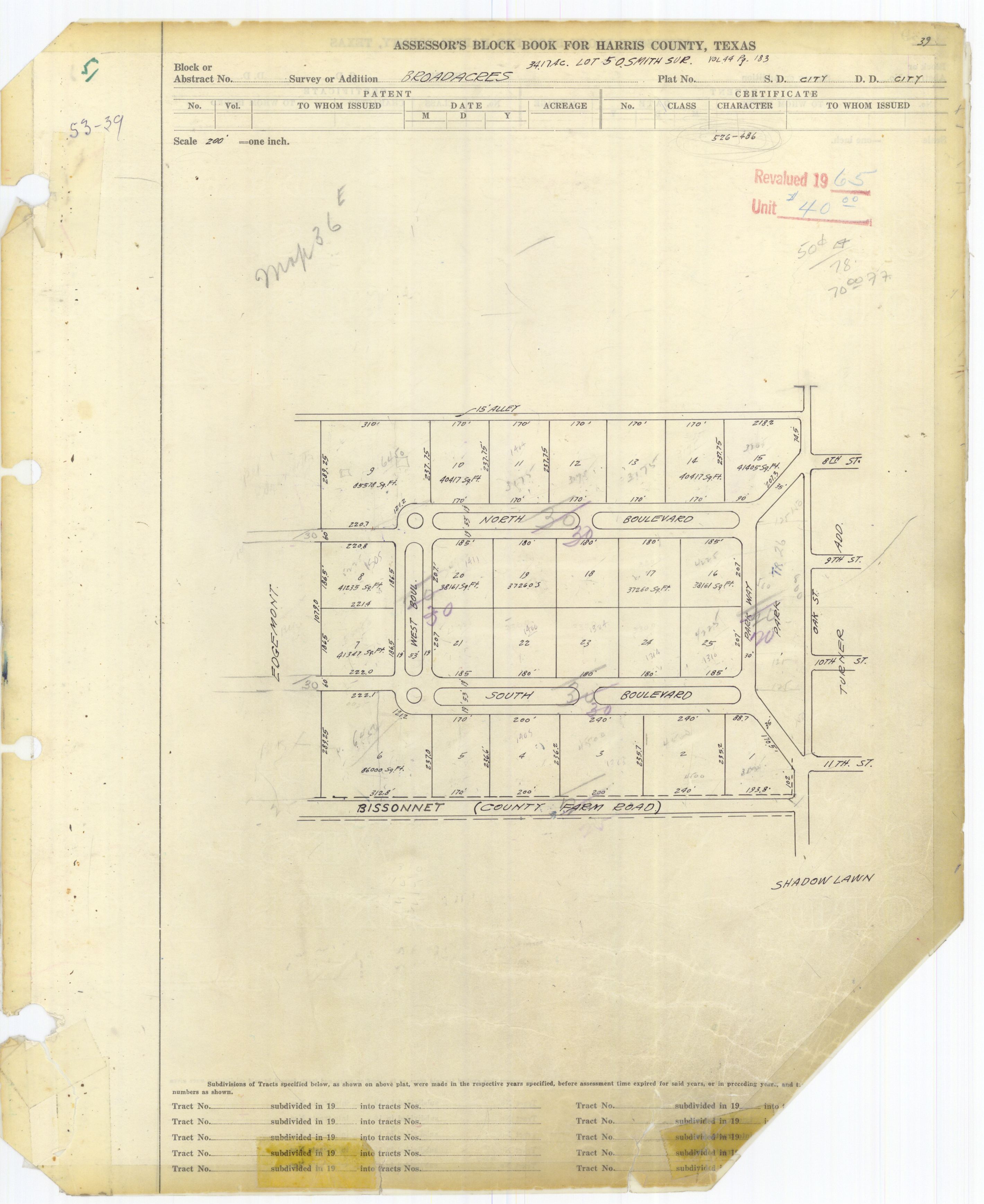
“In a way, this is just the latest battle in a hundred year old fight. On a Preservation Houston tour of Broadacres (where we trespassed all over the esplanades), it was pointed out that the neighborhood was originally designed as a closed loop with the only access to the city via Parkway to the east. Houston, however, viewed the streets as public and forced the developers to cede ROW through the lots on the western side of the loop to connect North and South Blvds to their counterparts in the west. This is why North and South Blvds pinch weirdly right around West Blvd. — when you’re ceding expensive land, you only give the minimum required. . . .” [Cactus, commenting on Who Owns the Esplanades on North and South Boulevards?] Photo of Broadacres assessor’s map: HCAD

06/05/17 12:30pm

WESLAYAN’S CRUEL TWIST SLAYS Reader Adam Goss, who identifies himself as a Houstonian — and a graduate of Wesleyan University in Connecticut — writes that it “drives him insane” that “the street named after our alma mater is misspelled. All the surrounding streets are named after similar universities and colleges (Amherst, Oberlin, Georgetown), yet for some reason the largest of all, Weslayan, is spelled incorrectly. How would Rice grads like it if a major thoroughfare in Chicago was named after the famed Houston university, Rize Avenue. Or if Boston named a major street Longhornes, after a famed UT alum?” Photo of street sign at the corner of Weslayan and W. Alabama St.: Jeremy Hughes

05/25/17 2:00pm

Not to be outdone by last week’s midday plug-up of the Alfred Hernandez Tunnel beneath the railroad tracks and the Burnett TC Red Line stop, another semi making its way through the passage got lodged in the tunnel late this morning — getting torn open end-to-end in the process. But that’s not even the first truck stuckage incident at the underpass in the last 24 hours, according to a reader who’s had both a camera and a Twitter account trained on the recently retooled intersection for at least the last few months.

The reader tells Swamplot that another truck got stuck briefly last night, and that it happens about 6 times a week: “Our camera system auto-wakes when it hears something beyond a certain threshold; most drive away, presumably nervous[ly] on their way to have a talk with the boss.” Some work on the tunnel has been on the city’s docket this spring, and was approved at a mid-April meeting; that’s likely to start around the end of the month. 

Here’s the scene from above as of early this afternoon:

CONTINUE READING THIS STORY

Near-Daily Grind in Near Northside
05/11/17 2:30pm

Here’s your chance to see in first person what the city’s come up with for that under-discussion redo of Westheimer Rd. in Montrose. The video above flies viewers slowly through a flatly rendered Westheimer corridor east of Shepherd Dr. (complete with digital versions of all your favorite ex-clothing shops, storied condo buildings, and paired Mattress Firms) with the new street plan in place. Reality check with the existing state of the roadways happens at a handful of the corridor’s intersections.

The biggest change: A drop down to 2 lanes of car traffic in most places (versus the 4 narrow lanes currently in place), beginning around Huldy St. and moving east. The road would briefly widen back out to 4 lanes around the crossing of Montrose Blvd., then back down to 2 until the name swap to Elgin St. at Bagby St. All that slimming down leaves room for wider sidewalks; the plan also includes some set-aside zones for bus drop-off, some left turn lanes, and a few stretches of parallel parking areas, highlighted in pink.

CONTINUE READING THIS STORY

Montrose Flyby
02/21/17 4:00pm

7200 Main St., TMC, Houston, 77030

The sign above announcing the proposed abandonment of the short dead-end stretch of N. Braeswood Blvd. running east of Main St. was captured in situ by a reader over the weekend. The roadway currently serves as the access road for the remaining Saint Nicholas School campus, though the school is planning to be all moved in at that new facility further south along Main St. in about a year and a half. That’ll free up the landf for whatever might be in the works by shell corporation 7200 Main St., which now owns both the school property and the 8-plus-acre tract north of the N. Braeswood segment, former site of barn-shaped restaurant The Stables.

To the east of the orange-roofed soon-to-be-former Saint Nicholas school, HCC’s  Coleman College for Health Sciences building looks to be just about wrapped up, at least in terms of exterior finishes:

CONTINUE READING THIS STORY

Medical Center Excision
11/21/16 5:15pm

Brick tearup in Freedmen's Town Historic District, Andrews St., Fourth Ward, Houston, 77019Brick tearup in Freedmen's Town Historic District, Andrews St., Fourth Ward, Houston, 77019

Some more friends of historic bricks — this time, specifically, of the bricks in the Freedmen’s Town Historical District in Fourth Ward — caught contractors tearing up part of the brickwork on Andrews St. this morning, reports Jeff Ehling. Mayor Sylvester Turner says via Twitter from Mexico that nobody was supposed to have messed with the bricks, which were put under a protective order last year after another short-lived bout of street tearup; Turner adds that he’ll deal with it when he gets back. A reader on the scene snapped a few photos of the torn up section, at the intersection with Genessee St. east of the Gregory-Lincoln Education Center campus:

CONTINUE READING THIS STORY

Second Stop in Fourth Ward
07/14/15 2:30pm

Burnett St., Near Northside, Houston

With a row of Downtown towers looking on from the south, 2 lanes are being added to Burnett St., along the northern boundary of the 50-acre site formerly known as the Hardy Rail Yards. The thickening runs between N. Main St. and Hardy St. At the western end of that stretch, next to the Burnett Transit Center stop on the Red Line’s northern extension, a new baby intersection has been born at Freeman St. just in front of the rail overpass, just up a ways from the N. Main tunnel:

CONTINUE READING THIS STORY

Grid Growth