05/25/17 2:00pm

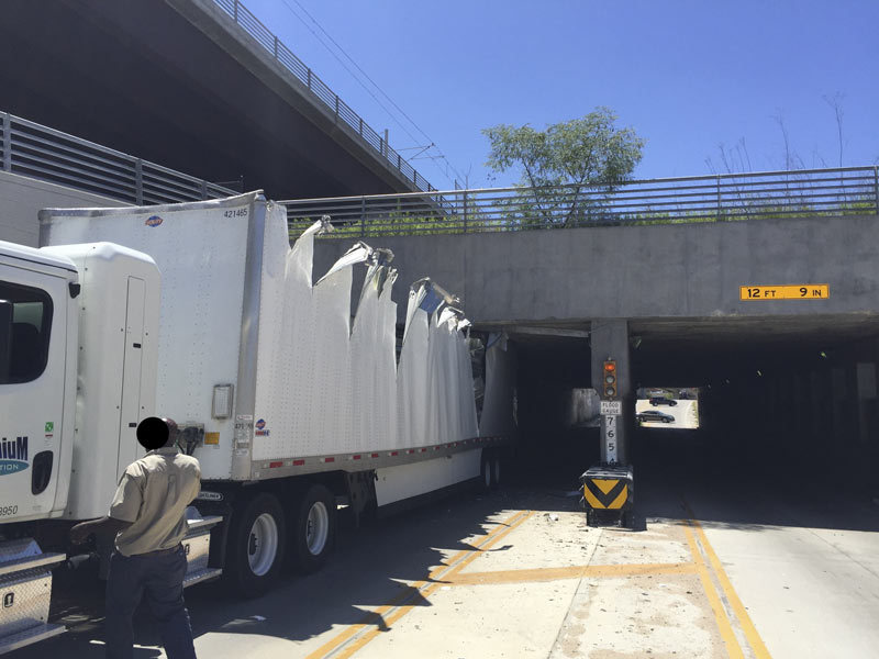
Not to be outdone by last week’s midday plug-up of the Alfred Hernandez Tunnel beneath the railroad tracks and the Burnett TC Red Line stop, another semi making its way through the passage got lodged in the tunnel late this morning — getting torn open end-to-end in the process. But that’s not even the first truck stuckage incident at the underpass in the last 24 hours, according to a reader who’s had both a camera and a Twitter account trained on the recently retooled intersection for at least the last few months.

The reader tells Swamplot that another truck got stuck briefly last night, and that it happens about 6 times a week: “Our camera system auto-wakes when it hears something beyond a certain threshold; most drive away, presumably nervous[ly] on their way to have a talk with the boss.” Some work on the tunnel has been on the city’s docket this spring, and was approved at a mid-April meeting; that’s likely to start around the end of the month. 

Here’s the scene from above as of early this afternoon:

CONTINUE READING THIS STORY

Near-Daily Grind in Near Northside
03/22/17 11:00am

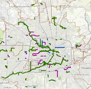
HOUSTON BIKE PLAN UP FOR A VOTE AGAIN THIS MORNING AMID MORE CALIFORNIA-IZATION FEARS Existing High Comfort Bike Lanes, Houston Bike Plan ca. March 2017This morning’s city council meeting has the Houston Bike Plan back on the docket, following the most recent round of public-input-based tweaking to the plan (as well as a delay of the vote, which was initially scheduled for earlier this month). Over in the Chronicle Dug Begley recaps some of the arguments being made for and against the years-in-development guidance plan, which have a bit of a chicken-vs-egg flavor: do only 0.5% of Houstonians bike to work because safe-feeling bike paths are scarce outside of certain Inner Loop neighborhoods? Or are those areas where the active bikers are already clustered the only ones where bike path improvements are warranted? Councilman Greg Travis, one of the folks who pushed back the vote at the last council meeting, told Begley he does see a need for some kind of bike safety improvement plan, but adds that he’s “not sure this is the plan for Houston. We’re not Amsterdam or San Francisco, and we don’t know what’s needed here, really needed.“ [Houston Chronicle; previously on Swamplot] Map of existing ‘high-comfort’ bike paths: Houston Bike Plan Interactive Map
02/10/17 11:00am

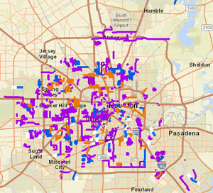
CITY LOSES LATEST APPEAL ON 2010 DRAINAGE FEE ELECTION City of Houston Public Works Project MapThis week the state’s Fourteenth Court of Appeals upheld a 2015 ruling calling for a new election on the ReBuild Houston drainage and road-fixup fee. As in another local case involving charter invalidation and large sums of collected assessment money, the city is mulling over further appeal options, though the case’s last trip to the Texas Supreme Court didn’t go in the city’s favor. The Chronicle‘s Katherine Driessen also writes that the fund’s future is now murky: the decision doesn’t stop the city from collecting the fee for now, since that collection was authorized through another city ordinance — it may, however, remove restrictions on how the money can be used. [Houston Chronicle; previously on Swamplot] Map of past, ongoing, and planned drainage and street projects: ReBuild Houston interactive map
09/06/16 12:00pm

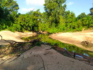
STOP TRYING TO FIX BUFFALO BAYOU, SAYS SAVE BUFFALO BAYOU Buffalo Bayou Bank Shift The waterway enthusiasts at Save Buffalo Bayou just issued their report on their recent tours of the waterway, with an eye toward how the scene has changed in the wake of the Tax Day flooding and the extended high flows from the try-not-to-make-things-worse paced drainage of the Addicks and Barker reservoirs. The photo above, taken during the organization’s scouting, shows an area of the bayou where the river channel dug through a curve and moved over, such that some landmarks previously on the north bank are now on the south side. The authors take issue with a number of current and proposed plans to keep the bayou’s banks in place, and suggest that the best way to end up with a relatively stable channel is to step back and let geology do the job: “When the bayou’s banks slump or collapse, the brush and fallen trees left in place collect sediment during subsequent high waters, gradually rebuilding naturally reinforced banks. These new nature-built banks are better able to withstand subsequent floods as well as the more powerful flows being released from the dams . . . The bayou itself then reseeds these and other sandy areas with the proper succession of plants that first colonize then stabilize the sediment, turning sand into soil, preparing the way for seedlings of trees. It’s part of the natural function of riverine flooding that we rarely have opportunity to observe, especially in the middle of a city where we have dug up and covered in concrete most of our bayous and streams.” [Save Buffalo Bayou; previously on Swamplot] Photo: Save Buffalo Bayou
08/29/16 5:00pm

The larger the dot in the interactive map above, the more frequently the surrounding ZIP code deals with sewage overflows, per to the city’s tally of sewage spills between 2009 and 2014. The map, put together by Rachael Gleason with data prepped by John Harden and Mike Morris, goes along with Morris’s update in the Chronicle this weekend on the city of Houston’s ongoing negotiations with the EPA over what to do about the city’s sewage-related water quality issues, with the estimated cost of required infrastructure upgrades and education programs on the horizon currently hanging out in the neighborhood of $5 billion dollars.

The Chronicle’s analysis also notes that most of the areas with above-average sewage spill rates are home to above-average poverty rates, as well as above-average proportions of black and Hispanic residents than the city as a whole. The map above allows readers to superimpose the spill numbers over each ZIP code’s median income and poverty rate (you’ll have to look elsewhere for maps backing up the other claim, though). Another map released earlier this summer pinpoints more precisely the spots where the sewage flows most freely — areas in purple below have seen a minimum of 45 documented sewage spills in the 5-year data period:

CONTINUE READING THIS STORY

Sniffing Out the Cause
08/29/16 1:30pm

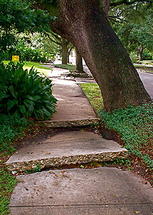
FINDING THE RIGHT WORDS TO TALK THROUGH HOUSTON’S RELATIONSHIP WITH SIDEWALKS Broken Sidewalk, Boulevard Oaks, HoustonTaking together a recent rash of of essays complaining about Houston’s walkability, public transit, and sidewalk situation, Joe Cortwright over at City Observatory offers some thoughts on why it might be harder for city planners to buff up the city’s walking infrastructure than focus on its car standards: planners, both locally and nation-wide, don’t have as many ways to measure unpleasant walking experiences, or sufficient language to describe them. Cortwright writes that the anecdotes and narratives put forth by Houston’s frustrated would-be walkers are “rich and compelling in their detail, but lack the technocratic throw-weight of quantifiable statistics or industry standards to drive different policies and investments in our current planning system. [ . . . But] this isn’t simply a matter of somehow instrumenting bike riders and pedestrians with GPS and communication devices so they are as tech-enabled as vehicles. An exacting count of existing patterns of activity will only further enshrine a status quo where cars are dominant. For example, perfectly instrumented count of pedestrians, bicycles, cars in Houston would show — correctly — little to no bike or pedestrian activity. And no amount of calculation of vehicle flows will reveal whether a city is providing a high quality of life for its residents, much less meeting their desires for the kinds of places they really want to live in.” [City Observatory] Photo: Flickr userbpawlik

08/18/16 3:15pm

DIVINING HERMANN PARK’S FUTURE TRANSIT NEEDS New Hermann Park TrainAnother 20-year master plan for Hermann Park is currently in the works as the last one gets wrapped up, writes Molly Glenzter this morning. Per designer Chris Matthews, who’s working on the project as part of landscape architecture firm Michael Van Valkenburgh Associates, the planning isn’t all “fun things like choosing what tree to plant:” unlike the 1995 master plan redo, the design team this time includes a “consultant for all things mobile, which in the old days used to mean cars. Now it means cars, bikes, transit and pedestrians — how to balance all that stuff.” Matthews notes that the planning is further complicated by the need to predict what mass transit will look like 2 decades from now; Hermann Park Conservancy president Doreen Stoller adds that “with Houston getting ever more dense, each square inch of park space is becoming more precious and will need to be put to its highest and best use.“ [Houston Chronicle; previously on Swamplot] Photo of Hermann Park kiddie train: Lou Minatti
07/14/16 2:30pm

COMMENT OF THE DAY: STRAIGHTENING OUT THE CONCRETE-LINED BAYOU PARADOX white-oak-bayou“While I am no run-off-water-channeling expert, I am under the impression that tossing out the concrete is not just for appearances. The concrete ditch moves the water faster than the natural channel, and can [thereby] actually aggravate flooding rather than cure it. Returning to the natural channel structure may mitigate flooding.” [Al, commenting on Might White Oak Bayou Ditch Its Concrete?] Photo of White Oak Bayou channel: Swamplot inbox
07/13/16 5:15pm

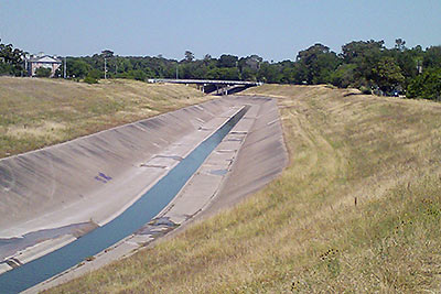
MIGHT WHITE OAK BAYOU DITCH ITS CONCRETE? white-oak-bayouThe Harris County Flood Control District is looking at removing the concrete lining from sections of the White Oak Bayou channel, writes Mihir Zaveri. The agency is conducting a study on redeveloping parts of the waterway along with the Memorial-Heights Redevelopment Authority (a.k.a. TIRZ 5); any future projects to come from the study would be within the TIRZ 5 boundaries, along sections of White Oak between roughly N. 610 and Houston St. Zaveri writes that the push “in part reflects the idea that waterways where flooding must be controlled don’t have to be eyesores, and in fact can become more natural settings for residents to bike, walk and gather. It follows decades-old conversations about how to shape waterways in a flood-prone region like Houston, where the rapidly growing population has increasingly come to demand improvements in quality of life.” With respect to balancing aesthetics against effective flood control practices, TIRZ 5 chairwoman Ann Lents tells Zaveri that “pretty is never going to trump functional . . . But because of new techniques, if we can find a way to do both better, I think that will be a great thing.” [Houston Chronicle] Photo of White Oak Bayou: Swamplot inbox
06/07/16 10:15am

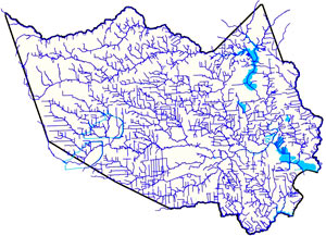
THE ESTIMATED PRICETAG ON A STOP TO HOUSTON FLOODING Harris County Flood Control District channel mapAmid the latest round of area flooding last week, Dylan Baddour traces the roots of Houston’s massive publicly funded drainage projects, which have brought the total length of Harris County waterways up to 2,500 miles (many of those channels widened, lined with concrete, or dug from scratch). Baddour also talks with current county flood control district director Mike Talbott about what it would take to expand and refine the city’s outdated flood infrastructure (which is often locked into place by close surrounding development) up to modern expectations — namely, that the flow of water over land that would otherwise be totally submerged should be totally controlled. Baddour writes that Talbot “has a simple solution: allocate $26 billion, more than a fifth of the state’s 2015 budget, mostly to buy property adjacent to the waterways, bulldoze and expand the canals.” Rice University ecologist Ron Sass tells Baddour he’s surprised the city hasn’t been tearing down old houses to build new bayou channels: “We build freeways. I would think that a bayou would be as important to our infrastructure as a freeway.” [Houston Chronicle] Map of Harris County waterways: Harris County Flood Control District  

05/11/16 11:00am

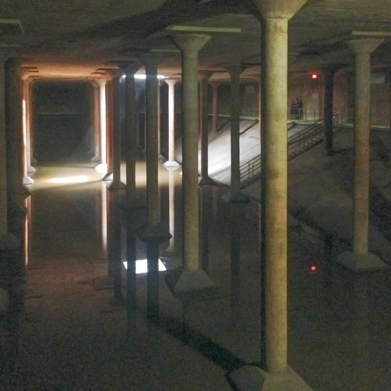
The Cistern, Buffalo Bayou Park near Sabine St. at Memorial Dr., Houston, 77007

Friday’s tours of the 1920s underground water reservoir buried along Buffalo Bayou are already booked up, but the space will be open to the public Thursdays through Sundays from here on out. A 30-minute tour of the Cistern is $2 (except on Thursdays, when access is free), but reservations are required either way.

Can’t wait for the next open timeslots to scope out the space? Artist Donald Lipski’s Down Periscope is already up and running on the lawn above the reservoir, allowing digital spelunkers access to a light, a camera, and a microphone permanently installed in the space below. Off-site viewers can also queue up on the contraption’s website to take remote control of the installation for 5-minute intervals and swivel around in the underground chamber at will:

CONTINUE READING THIS STORY

What’s Down Below
05/04/16 2:45pm

ENTIRE LOUISIANA ISLAND POPULATION TO BE TRANSPLANTED WITH FEDERAL ‘CLIMATE RESILIENCE’ FUNDS Meanwhile, in Isle de Jean Charles: Planning is currently in the works to resettle roughly 60 people following the gradual disappearance of more than 90 percent of their island due to a combination of industrial and climate change factors, including sea level rise, subsidence, erosion along manmade channels, and the blocking of wetland-rebuilding sediments by levees and other flood-control structures. The community, mostly members of the Biloxi-Chitimacha-Chocktaw tribe, is frequently blocked by flooding from jobs and schools on the mainland. In January, the first-ever  federal National Disaster Resilience Competition awarded $92 million dollars to the state of Louisiana, which has lost nearly 1,900 square miles of coastal land since the 1930s. Some of the money will go to the Isle de Jean Charles move, and the rest will seed a state fund to help finance other coastal “resilience” projects anticipated in the coming years. A total of $1 billion dollars for similar projects was awarded through the competition to 13 applicants (8 states and 5 communities); the city of New Orleans received a separate grant for $141 million. [New York Times, U.S. Dept. of Housing and Urban Development]

02/23/16 2:30pm

COMMENT OF THE DAY: TOP WITH ASPHALT, ADD PARKING STRIPES TO TASTE Parking Lot“Amazing how that works – we demolish houses and businesses next to schools to make way for parking, meaning there will be fewer homes and errand stops within walking distance of the school. Meanwhile, the Red Line is only a few blocks away, which could’ve meant fewer employees and students needing to drive there. So now we have HISD paying more money it doesn’t have on acquiring land and building parking infrastructure while simultaneously devaluing a public transit asset and decreasing the school’s user base in the area. Great recipe for success, here!” [Derek, commenting on Former Bakery Razed as Jefferson Davis Claims New Territory in Northside] Illustration: Lulu

02/03/16 4:15pm

COMMENT OF THE DAY: IT’S NOT THE SIZE OF INFRASTRUCTURE, IT’S HOW YOU USE IT Freeways“This is less about the size and population of cities, and more about growth and how it’s handled. . . . Growth has terrible problems; rapid growth makes those problems worse, and poor planning makes them worse. But the alternative of urban decline is far worse than even rapid, poorly planned growth. It’s easy to complain about traffic and overcrowded schools, higher housing costs and overextended public services. But would you really rather live with a decaying, unused infrastructure that local government can’t afford to maintain, and schools that are shutting down and neglected? Would you rather watch as the tax base erodes and the City government goes defunct? Would you want to sell your house at a steep loss? Not me. Look at Chicago. Look at what Detroit went through. Sure, the traffic jams are a thing of the past, but at what cost? One other thing to note is that small cities and rural areas can struggle with growth, too. Look at what happened in Karnes County when the Eagle Ford Shale boom was going on. They had problems with traffic, dangerous roads, a lack of housing and skyrocketing prices, overcrowded schools . . .” [ZAW, commenting on Comment of the Day: Drawing a Line on Urban Expansion] Illustration: Lulu

01/22/16 4:50pm

LARGEST OIL SPILL IN U.S. HISTORY WILL FUND GREENWAYS ON CLEAR CREEK Clear Creek Trash CleanupMoney from the Gulf Coast Restoration Trust Fund, set up with part of the $18.7 billion BP paid last summer to settle with the federal government over the Deepwater Horizon oil spill, is making its way to Houston in the form of a $7.1 million grant supporting the Houston Parks Board’s Bayou Greenways 2020 project. Joe Martin of the HBJ reports that the money will be used to purchase and preserve parkland along the Clear Creek Greenway, which runs along Clear Creek from Missouri City to Clear Lake via Pearland, Friendswood, and League City. The 2020 plan calls for the cleanup and connection of greenspace along all of Houston’s major bayous. The 2012 RESTORE Act channels funds from the BP settlement into ecological restoration, economic development, and promotion of tourism in Texas and the other Gulf Coast states impacted by the spill, as well as scientific research on the Gulf of Mexico. [HBJ] Photo of Clear Creek annual trash cleanup: Clear Creek Environmental Foundation