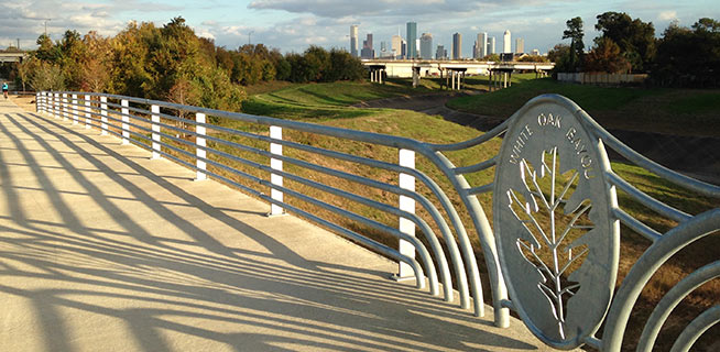
WHAT’S BLOCKING THE BRAYS BAYOU TRAIL  That sign posted just west of Chimney Rock declaring that the Brays Bayou trail “connects 31 miles of uninterrupted, off-street, multi-use trails and greenspace from the Ship Channel to George Bush Park and the Addicks-Barker Reservoir” is more aspirational than accurate at this point, a Houston Parks Board official admits to David Olinger. (“It got ahead of itself, let’s put it that way.”) Olinger set out to walk the supposed marathon-distance-plus continuum, but found it blocked and interrupted by construction zones, an unidentified fork to a neighboring bayou, and dead ends, including some fronting 7-miles-worth of land adjacent to Arthur Storey Park the parks board is still in the process of acquiring: “I tried walking west from Kirkwood and waded into knee-high weeds. I tried walking north on Kirkwood and found no trail. I drove up and down Kirkwood, searching in vain for Arthur Storey Park. Finally I consulted a map — and found the park about 2.5 miles northeast from the westbound Kirkwood dead end.” The Bayou Greenways trail system is expected to connect that length of Brays Bayou by 2020. [Houston Chronicle; previously on Swamplot] Photo of Brays Bayou trail: Jan Buchholtz
Sign up for the Newsletter
Tag: Bayou Greenways 2020

BAYOU-SIDE PSEUDO-ICE-HOUSE IDEA CATCHING ATTENTION OF HOUSTON PARKS BOARD 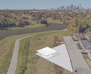 A tidbit tucked away at the bottom of Jen Kinney’s piece for Next City this week on architect and ice-house aficionado David Richmond’s speculative plan to put vaguely-ice-house-esque pavilion structures along Brays Bayou: the Houston Parks Board folks want to hear more about the idea. Richmond confirms to Swamplot that a meeting with some HPB reps did take place on Monday, and that the Bayou Greenways planners are interested in ways to attract more activity along the bayous, eventually — but says that the meetup was mostly to make introductions, and reiterates that there’s “nothing specific or formalized to report” at the moment. [Next City; previously on Swamplot] Rendering showing pavilion structure along Brays Bayou: David Richmond

Don’t feel like hopping on your bike to see how construction on that northern piece of the White Oak Bayou hike-and-bike trail is coming along? The click-and-drag-able digital map released this week by the Bayou Greenways 2020 folks may be a decent substitute for the real thing (depending on how often it ends up getting updated). Zoom in closer on the map above to check out completed trail sections (outlined in green), under construction spots (traced in dark purple), and areas planned for trail-ification at a later date (highlighted in a purple haze).
Here’s the area around Mason Park (where that double-V suspension bridge is under construction at the moment):
Green is for Greenway

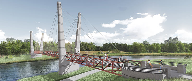
A double-V’d walkin’ and bikin’ bridge like the one shown above will be spanning Brays Bayou before too long, the Houston Parks Board says, linking together the sections of Mason Park separated by the waterway. The agency is planning a short mid-morning party for the planned structure’s construction kickoff next Tuesday, on the southern side of the park (mostly located east of the 75th St. crossing). The whole complex is just downstream of the Gus Wortham Golf Course, for which renovations finally teed off a few weeks ago (trailing much ado a few years back that culminated in the land not getting turned into a botanical garden).
The board says the other, decidedly less suspenseful pedestrian bridge announced earlier this year should be done in the fall as well; that one will will run across Brays alongside the Martin Luther King Blvd. car bridge at the downstream edge of of MacGregor Park, and look kinda like this:
Double Crossing Brays

HOUSTON PARKS BOARD RELEASES FLOCK OF BAYOU GREENWAY SIGHTSEEING SUGGESTIONS 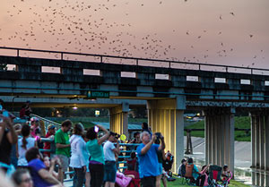 Not to be left out of the Super Bowl LI frenzy, the Houston Parks Board has been publishing weekly additions to what’s now a list of 51 “super” Bayou Greenways-accessible attractions — ranging in scope and scale from Buffalo Bayou Park to the Orange Show to a pair of nesting eagles somebody spotted near Greens Bayou. The list is broken up by watershed, with each bayou getting a separate map of sites along its existing or planned bike trails (though tour by kayak is also recommended in some places). Other entries on the list include the Watonga Blvd. bridge bat colony (on White Oak Bayou, south of Pinemont Dr., shown here), Parkwood Park in Riverside Terrance (off Brays Bayou and these days billed as Beyoncé’s childhood park), David Adickes’ Mount Rush Hour statue grouping in American Statesman Park (fringing the Downtown confluence tangle of I-10, I-45, and White Oak and Buffalo bayous), and NRG stadium itself, with a nod to the nearby Astrodome. [Houston Parks Board; previously on Swamplot] Photo of Watonga Blvd. bats: Houston Parks Board

The section of bayou-hugging greenway trail running between Durham St. and Stude Park is getting the official OK tomorrow morning from Harris County Flood Control District and the Houston Parks Board. The photo above is of the pedestrian bridge across White Oak near Durham St. that previously supplanted the area’s “Bridge of Death” route; the segment opening tomorrow runs from that same bridge east along the bayou to the Studemont St. non-pedestrian bridge. The organizers are hoping would-be trail fans will use some means other than car to get to the ceremony location (off Studemont just north of I-10); if you have to drive, however, the invitation says you might be able to get a parking space across the freeway north of  Target.
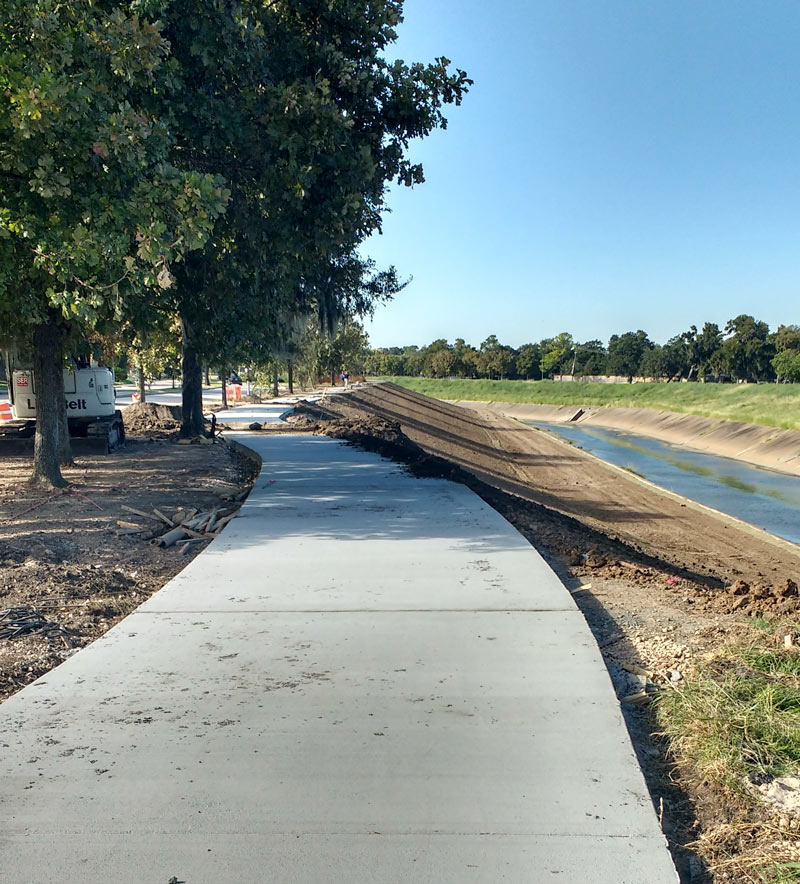
Further east along the White Oak trail, here’s an updated view of how that link into Near Northside by the Leonel Castillo Community Center is coming along (taken in mid-November, once again from the same spot as that glitzed-up flood photo that made an appearance in Air New Zealand’s recent in-flight feature on Texas):
Greenways Growth Spurts

A mobile reader sends some fresh shots of not-quite-green-yet redone greenway along Brays Bayou, looking west from Buffalo Spdway. along S. Braeswood Blvd. The Harris County flood control folks have been widening this section of the channelized stream this fall as they work their way through the Project Brays checklist; the stretch seen above and below is about 2 miles downstream of some of those more submersion-prone areas of Meyerland near the Brays crossing under 610.
The new trail is a fair bit wider and smoother than the one it’s replacing — for some soggy comparison, here’s a view of the trail from around noon on Tax Day, just up past the next bend near where Ilona Ln. meets S. Braeswood:
Widening Greenways and Waterways

COMMENT OF THE DAY: WILL HOUSTON STOP TURNING ITS BACK ON THE BAYOU GREENWAYS? 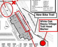 “This is revolutionary…they will make a building FACE the bayou, rather than back up to it with a solid concrete wall lined with putrid dumpsters. I have been waiting for this day for decades! To my knowledge, the only business in Houston that has proudly claimed its bayou-ness is Brenner’s on the Bayou (I’m sure there are others, I just can’t think of them right now). I bike many of the trails in Houston’s bayou network and still marvel at how segregated the trails are from city life. The stretch along Brays through the Med Center is the worst – it is a gallery of the backs of parking garages, 2 sewage plants, security fences, and sheer walls on high rises. It’s so barren and inaccessible that hospital employees go there to secretly smoke their cigarettes (some hospitals fire their employees for smoking now, so it’s a big deal to not get caught).” [Superdave, commenting on Bayou-Side White Oak Village Hopes To Woo Cyclists, Ninja Warriors, Coffee Shop to Antoine Dr.] Proposed siteplan: White Oak Bayou Village

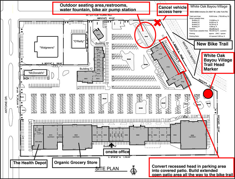
Plans are in the works to give the shopping center at the southwest corner of Antoine Dr. and W. Little York Rd. a thorough redesign and rebranding as White Oak Bayou Village. A spokesperson for Nankani Development tells Swamplot that the group is seeking both tenants and ideas for the center’s redevelopment, which will be geared toward drawing bicycle traffic. So far, plans include an about-face for the bayou-side building in the back of the shopping center (labeled Building B above) by way of new glassy storefronts opening toward the White Oak Bayou greenway now running behind it; the developers claim the center would become the first private development to cater explicitly to the expanding bayou trail system.
Per preliminary plans, car access to the back of the shopping center would be blocked off. Former parking spaces along the back Building B (currently home to Northwest Beauty School) would be made over into a covered patio leading to the bayou trail. For the pad site of the burned-down former restaurant next door, the development group is considering a park-like events plaza that could host a bi-monthly farmer’s market — along with a giant chess board, maybe, or even a bayou-side zip lining station. “We are open to anything at this point,” writes the Nankani rep.
Hoped-for tenants for the center currently include a coffee shop-slash-electric bike rental joint, an ice house-style music venue, and an outdoor obstacle course and adult gym — possibly from Sam Sann of American Ninja Warrior fame, who trains contestants at his Iron Sports gym in Cypress.
Bayou Turnaround

LARGEST OIL SPILL IN U.S. HISTORY WILL FUND GREENWAYS ON CLEAR CREEK  Money from the Gulf Coast Restoration Trust Fund, set up with part of the $18.7 billion BP paid last summer to settle with the federal government over the Deepwater Horizon oil spill, is making its way to Houston in the form of a $7.1 million grant supporting the Houston Parks Board’s Bayou Greenways 2020 project. Joe Martin of the HBJ reports that the money will be used to purchase and preserve parkland along the Clear Creek Greenway, which runs along Clear Creek from Missouri City to Clear Lake via Pearland, Friendswood, and League City. The 2020 plan calls for the cleanup and connection of greenspace along all of Houston’s major bayous. The 2012 RESTORE Act channels funds from the BP settlement into ecological restoration, economic development, and promotion of tourism in Texas and the other Gulf Coast states impacted by the spill, as well as scientific research on the Gulf of Mexico. [HBJ] Photo of Clear Creek annual trash cleanup: Clear Creek Environmental Foundation
