COMMENT OF THE DAY: THE PITS  “Up until the 1930s, most oil taken from the ground was quite simply stored in earthen pits. Oil penetrated the soil to about 30 feet vertically and 100 feet horizontally. Humble by itself had 6,000,000 barrels of earthen pit storage. Note that the world’s largest documented land-based oilspills (not related to the Gulf War) were the Lakeview Gusher in Kern County, California (9 million bbl) and Fergana Valley in Uzbekistan (2 million bbl). Deepwater Horizon was the worst maritime spill (4.1-4.9 million bbl). These pits are not considered spills, but the land around them is far more impacted than a spill site. Back then, when pits failed from flooding or erosion, that was often unreported.” [TheNiche, commenting on An Update on the Leaky Oil Well in Missouri City] Image: Lulu
Sign up for the Newsletter
Tag: Oil Spills

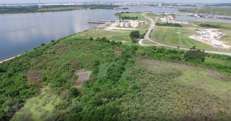
Some of the 42 acres of land just purchased for development by Avera Companies are shown here from above, east across the Ship Channel from the San Jacinto Battleground (that’s the bottom half of the star-topped obelisk visible toward the top left).  The property is on a peninsula of land about 2 miles downstream from the I-10 bridge and the San Jacinto Waste Pits. The eastern terminal of the Lynchburg Ferry can be seen here at the end of Independence Highway, with the Lynchburg reservoir lying  to the north.
The company says Kirby Inland Marine is set to be the first tenant for the property, and will use a section of the property to let up to 76 barges tie up and hang out as necessary. Kirby just agreed last month to a $4.9-million settlement with the Department of Justice over its role in that March 2014 barge-meets-carrier oil spill that shut down the Port for a few days and spread oil along roughly 160 miles of Texas coast between Galveston Bay and Padre Island National Seashore. (Kirby Offshore Marine, another of the corporation’s subdivisions, is currently dealing with fallout from last week’s tugboat-meets-shore fuel spill off the coast of British Columbia.)
Here’s a view of the rest of the property, showing a bit of Burnet Bay on the left and the San Jacinto River upstream toward I-10 on the right:
Floating Around Near Baytown

LARGEST OIL SPILL IN U.S. HISTORY WILL FUND GREENWAYS ON CLEAR CREEK 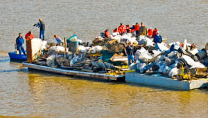 Money from the Gulf Coast Restoration Trust Fund, set up with part of the $18.7 billion BP paid last summer to settle with the federal government over the Deepwater Horizon oil spill, is making its way to Houston in the form of a $7.1 million grant supporting the Houston Parks Board’s Bayou Greenways 2020 project. Joe Martin of the HBJ reports that the money will be used to purchase and preserve parkland along the Clear Creek Greenway, which runs along Clear Creek from Missouri City to Clear Lake via Pearland, Friendswood, and League City. The 2020 plan calls for the cleanup and connection of greenspace along all of Houston’s major bayous. The 2012 RESTORE Act channels funds from the BP settlement into ecological restoration, economic development, and promotion of tourism in Texas and the other Gulf Coast states impacted by the spill, as well as scientific research on the Gulf of Mexico. [HBJ] Photo of Clear Creek annual trash cleanup: Clear Creek Environmental Foundation

GALVESTON BAY OIL SPILL: JUST A LITTLE TOPPING-OFF ACCIDENT According to the Coast Guard, the three-quarter-mile-long oil slick that made a few residents of San Leon feel a bit queasy, then washed up on the rocks at April Fool Point a week ago came from a spill caused by a Liberian-flag oil tanker — almost a week and a half earlier. The Omega Emmanuel reported a 50-gallon spill on February 8th as it was docked off Bolivar and taking on fuel from a barge. But the Coast Guard only tied the fuel oil to the tanker after environmental testing was completed this past Wednesday. “The cleanup ‘is complicated because the oil is embedded in the rocks,’ [Coast Guard petty officer Prentice] Danner said. ‘It takes slushing (agitation) to get it out, so I can’t speculate on how long it will take.'” Is that the same goo off the coast of Bacliff too? [Ultimate Clear Lake; previously on Swamplot]

Update, 2/24: Oh, just 50 gallons, they’re saying now.
Coast Guard officials have yet to determine the cause of the “oily sheen” that appeared in Galveston Bay last week, but the cleanup has continued for several days and workers have still not identified the source. A three-quarter-mile-long sheen off the coast at Sixth St. in San Leon “was making some residents feel ill” when it appeared last Thursday, according to a report in the Galveston County Daily News. About 30 workers from Phoenix Pollution Control and Environmental Services were still cleaning up oily goo from a mile-long stretch of shoreline near April Fool Point at San Leon’s southern tip, a Coast Guard official told the Chronicle‘s Robert Stanton today. But the photo above, showing the slick on rocks at Bacliff — on the far northwestern side of the same peninsula — was sent to abc13 earlier today by a photographer who comments that workers didn’t want pictures taken. Another photo submitted by the same person appears to show boom deployed in the water off Grand Ave.:
