COMING OFF THE STATE WATCHLIST DOESN’T MEAN HOUSTON’S POLLUTION HOTSPOTS DON’T STILL NEED TO BE WATCHED 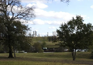 Of the 14 sites pulled off the Texas Commission for Environmental Quality’s special pollution watchlist since 2007, Elena Craft writes in the Chronicle’s Gray Matters column today, some 8 of them have since had new noteworthy upticks of various chemicals linked to health issues like breathing problems, nerve problems, or cancer, according to the Environmental Defense Fund’s recent study. Craft dives into some of the sticky aspects of trying to keep track of whether chemical levels are above normal for visitors and residents near spots like Milby Park (above) and the Lynchburg Ferry area, including the fact that the data collected by on-site monitors isn’t always available to the public right away, and that short-term high levels of problem chemicals don’t usually get investigated. “The absence of information about these seemingly random pollution spikes is troubling,” Craft writes, “because it suggests that TCEQ has stopped paying attention before its work is truly complete.” [Houston Chronicle; previously on Swamplot] Photo of Milby Park: Ric F.
Sign up for the Newsletter
Tag: Lynchburg Ferry

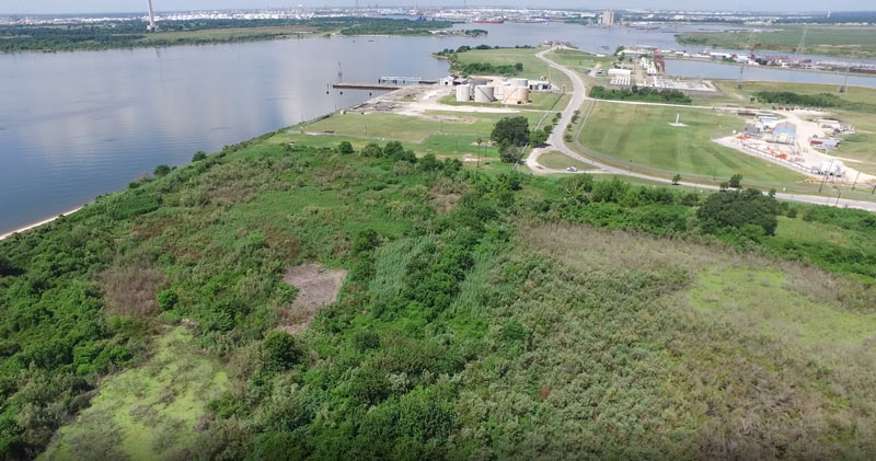
Some of the 42 acres of land just purchased for development by Avera Companies are shown here from above, east across the Ship Channel from the San Jacinto Battleground (that’s the bottom half of the star-topped obelisk visible toward the top left).  The property is on a peninsula of land about 2 miles downstream from the I-10 bridge and the San Jacinto Waste Pits. The eastern terminal of the Lynchburg Ferry can be seen here at the end of Independence Highway, with the Lynchburg reservoir lying  to the north.
The company says Kirby Inland Marine is set to be the first tenant for the property, and will use a section of the property to let up to 76 barges tie up and hang out as necessary. Kirby just agreed last month to a $4.9-million settlement with the Department of Justice over its role in that March 2014 barge-meets-carrier oil spill that shut down the Port for a few days and spread oil along roughly 160 miles of Texas coast between Galveston Bay and Padre Island National Seashore. (Kirby Offshore Marine, another of the corporation’s subdivisions, is currently dealing with fallout from last week’s tugboat-meets-shore fuel spill off the coast of British Columbia.)
Here’s a view of the rest of the property, showing a bit of Burnet Bay on the left and the San Jacinto River upstream toward I-10 on the right:
Floating Around Near Baytown
