
- 3200 Shelldrake Wy. [HAR]
SAN JACINTO MALL ANCHORS CAUSING REDO PLANS TO DRAG 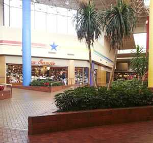 “It’s been slow and tedious — We didn’t count on the myriad problems all the traditional mall department stores are having,” Alan Hassenflu of Fidelis Realty Partners tells Katherine Blunt this week in the Chronicle, while discussing the company’s stagnating attempt to redo Baytown’s San Jacinto Mall. The company’s plans to knock down and rebuild the mall after buying it last summer are running up against drawn-out negotiations with tenants who signed restrictive covenants back in the early 80’s — agreements which can mean developers have to get those tenants to okay changes to the mall, and which can last for decades longer than original operating agreements. “In the case of San Jacinto,” writes Blunt, “the 3 remaining department stores have occupied their buildings for far longer than required under the operating agreements. But the restrictive covenants remain in place, giving them the some control over the mall’s future.” [Houston Chronicle; previously on Swamplot] Photo: Ray D.
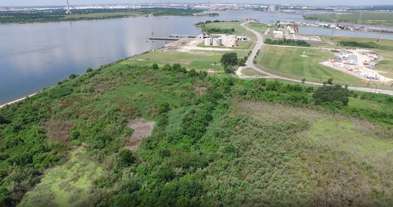
Some of the 42 acres of land just purchased for development by Avera Companies are shown here from above, east across the Ship Channel from the San Jacinto Battleground (that’s the bottom half of the star-topped obelisk visible toward the top left).  The property is on a peninsula of land about 2 miles downstream from the I-10 bridge and the San Jacinto Waste Pits. The eastern terminal of the Lynchburg Ferry can be seen here at the end of Independence Highway, with the Lynchburg reservoir lying  to the north.
The company says Kirby Inland Marine is set to be the first tenant for the property, and will use a section of the property to let up to 76 barges tie up and hang out as necessary. Kirby just agreed last month to a $4.9-million settlement with the Department of Justice over its role in that March 2014 barge-meets-carrier oil spill that shut down the Port for a few days and spread oil along roughly 160 miles of Texas coast between Galveston Bay and Padre Island National Seashore. (Kirby Offshore Marine, another of the corporation’s subdivisions, is currently dealing with fallout from last week’s tugboat-meets-shore fuel spill off the coast of British Columbia.)
Here’s a view of the rest of the property, showing a bit of Burnet Bay on the left and the San Jacinto River upstream toward I-10 on the right:

COMMENT OF THE DAY: THAT SINKING FEELING  “At 13 seconds in, those houses across the water at the top of the frame are at the end of my street, South Burnett Drive, in the Lakewood subdivision. The street rises gradually as you travel away from the water, but the low end of the street lost over 20 houses during Hurricane Ike. Some owners have rebuilt on pilings, some have rebuilt at grade, and others have abandoned the property. (My own house is further up the street, at about 31 feet elevation.) The end of the flood debris field from Ike was about three lots south of my house. So, while the name ‘Swamplot’ is amusing, to some of us it is no joke.” [Reeseman, commenting on Flying High Over the Baytown Subdivision That Sunk] Illustration: Lulu
Here’s some raw footage from a camera-wielding drone flight landscape artist and researcher Steve Rowell piloted earlier this year over portions of the Baytown Nature Center, the Crystal, Scott, and Burnet Bay peninsula that not too long ago was the home of the tony Brownwood subdivision — before it got all sinky and decided to subside 10 or so feet into the water. In some portions of the video, you can still spot the occasional home or garage slab from a fifties- or sixties-era rancher or 2, not to mention concrete broken up from other foundations and driveways and recycled on-site into surge barriers that now control the more recent, court-ordered wetlands environment.

Here come more billboard double entendres: The Baytown Sun reports that Buc-ee’s is building a big ’un on the I-10 feeder and John Martin Rd. later this year. And, apparently, the proposed 60,000-sq.-ft. convenience store, gas station, and jerky trafficker will get top billing: Part of the deal — a Chapter 380 Agreement — involves a waived height restriction for the store’s beaver beacon, so Buc-ee’s can raise one 100 ft. into the air. In return, Baytown will get a bit of room to put its own name up there too. (This will be the first time, the Sun reports, that Buc-ee’s will share its sign.) The store’s planned for about 18 acres on the southwest corner of John Martin Rd. and I-10 near the San Jacinto Mall. The Sun reports that it’s expected to open in 2014.
Photo of Lake Jackson Buc-ee’s: Judy Baxter [license]

FAST FOOD FIRE FOAM FAKE-OUTS Acting on the orders of a prank caller, managers of 2 local Arby’s locations recently ended up spraying foam all over their kitchen and food-prep areas. The caller, claiming to be from the local fire department, said that the system had been turned off, but instructed the manager in each instance to pull the lever that activates the fire suppression equipment — to allow the department to perform a test. At the Arby’s on Garth Rd. in Baytown, the foam caused at least $600 in physical damage and significantly more in loss of business during the cleanup. At an Arby’s in Clear Lake, employees “followed the instructions from the caller even further and broke out the windows of the restaurant, according to [Baytown Detective Lt. Eric] Freed. The Jack-In-The-Box on Decker Drive in Baytown also got a similar call, but did not do anything that the caller said to do, he said.” [Baytown Sun]


