06/26/17 10:45am

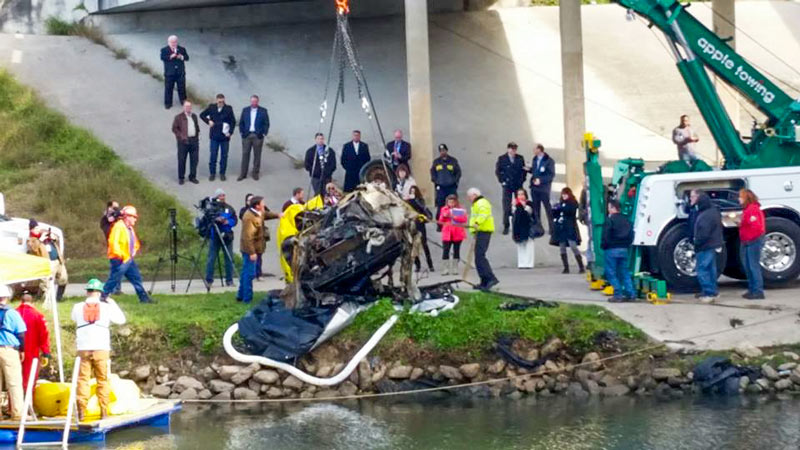
A stolen Dodge Durango was the first car pulled out of Brays Bayou earlier this month as Harris County Flood Control and friends resumed work on removing some of the 100-plus sunken vehicles previously discovered gently rusting below the surface of a few of Houston’s major waterways. (The Nissan Maxima above was next in line.) Last year’s test run of the removal setup snagged a total of 20 cars out of Brays and Sims bayous; the contracts signed earlier this year for a new round of vehicle fishing budget for a catch of around 65 vehicles from the 2 bayous, depending on size and how much of a fight each one puts up. (Texas Equusearch did note back in its 2011 survey that at least one big rig is lurking somewhere in the watery depths, and some of the cars are more filled with mud and debris than others.)

The county says the new car count was up to 13 by the time work crews paused last week to let Cindy pass; a county worker also snapped photos showing off some of the haul, which has so far included a range of more and less easily identifiable makes and models including a Nissan Frontier, a Jaguar, a Ford Mustang, a Ford Bronco, an Eagle Talon, and others:

CONTINUE READING THIS STORY

2,000-Pounders
01/05/17 12:45pm

JUST HOW MUCH FLOODING IS TOO MUCH FLOODING FOR HOUSTON? Flooding around The Halstead 4620 N Braeswood Blvd., Meyerland, Houston, 77096We pretty much know what we would have to do to stop most Houston flooding, writes Dylan Baddour as the calendar flips to 2017.  Potential paths to drier ground for the city include a multitude of complex region-wide tasks, including changes to waterways across the county, adding thousands of acres of detention space, and potentially addressing the cumulative impacts of seemingly minor small-scale building practices.  The cost of upgrading the whole system, including buyouts, bayou widenings, and utility rerouting, is estimated by the county flood control folks at around $27 billion — and that’s just to get protection up to so-called 100-year storm levels; Houston has had 8 such storms in the past 27 years, and the Tax Day flood was fueled by a much larger event. “What needs to be decided,” Baddour writes, “is how far taxpayers are willing to go. Cars don’t have airbags to absorb a hit from a train. Should Houston have a drainage system to contain a biblical storm? Where does the city draw the line?” City flood czar Steve Costello tells Baddour that the city has to do something, however, to avoid passing on a “potentially insurmountable problem” to future Houstonians. [Houston Chronicle] Photo of N. Braeswood Dr. at 610 on April 17, 2016: Chris Klesch

10/13/16 11:00am

Brays Bayou from Buffalo Speedway to Bevelyn, Linkwood, Houston, 77025

A mobile reader sends some fresh shots of not-quite-green-yet redone greenway along Brays Bayou, looking west from Buffalo Spdway. along S. Braeswood Blvd. The Harris County flood control folks have been widening this section of the channelized stream this fall as they work their way through the Project Brays checklist; the stretch seen above and below is about 2 miles downstream of some of those more submersion-prone areas of Meyerland near the Brays crossing under 610.

The new trail is a fair bit wider and smoother than the one it’s replacing — for some soggy comparison, here’s a view of the trail from around noon on Tax Day, just up past the next bend near where Ilona Ln. meets S. Braeswood:

CONTINUE READING THIS STORY

Widening Greenways and Waterways
07/13/16 5:15pm

MIGHT WHITE OAK BAYOU DITCH ITS CONCRETE? white-oak-bayou
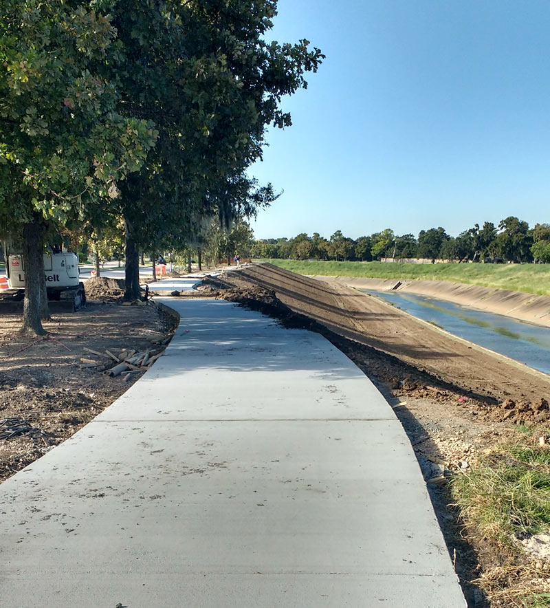
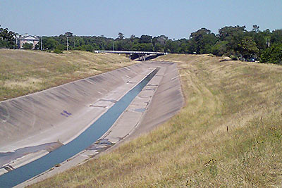
The Harris County Flood Control District is looking at removing the concrete lining from sections of the White Oak Bayou channel, writes Mihir Zaveri. The agency is conducting a study on redeveloping parts of the waterway along with the Memorial-Heights Redevelopment Authority (a.k.a. TIRZ 5); any future projects to come from the study would be within the TIRZ 5 boundaries, along sections of White Oak between roughly N. 610 and Houston St. Zaveri writes that the push “
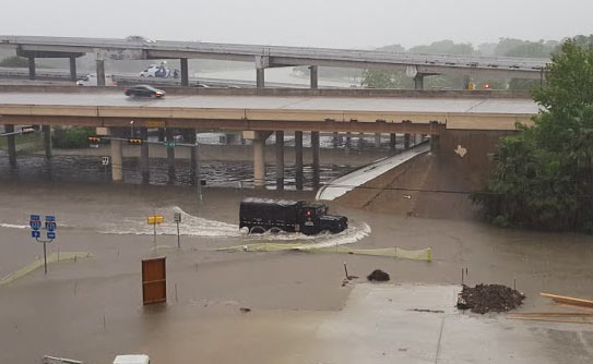
in part reflects the idea that waterways where flooding must be controlled don’t have to be eyesores, and in fact can become more natural settings for residents to bike, walk and gather. It follows decades-old conversations about how to shape waterways in a flood-prone region like Houston, where the rapidly growing population has increasingly come to demand improvements in quality of life.” With respect to balancing aesthetics against effective flood control practices, TIRZ 5 chairwoman Ann Lents tells Zaveri that “pretty is never going to trump functional . . . But because of new techniques, if we can find a way to do both better, I think that will be a great thing.” [Houston Chronicle] Photo of White Oak Bayou: Swamplot inbox

06/07/16 10:15am

THE ESTIMATED PRICETAG ON A STOP TO HOUSTON FLOODING Harris County Flood Control District channel mapAmid the latest round of area flooding last week, Dylan Baddour traces the roots of Houston’s massive publicly funded drainage projects, which have brought the total length of Harris County waterways up to 2,500 miles (many of those channels widened, lined with concrete, or dug from scratch). Baddour also talks with current county flood control district director Mike Talbott about what it would take to expand and refine the city’s outdated flood infrastructure (which is often locked into place by close surrounding development) up to modern expectations — namely, that the flow of water over land that would otherwise be totally submerged should be totally controlled. Baddour writes that Talbot “has a simple solution: allocate $26 billion, more than a fifth of the state’s 2015 budget, mostly to buy property adjacent to the waterways, bulldoze and expand the canals.” Rice University ecologist Ron Sass tells Baddour he’s surprised the city hasn’t been tearing down old houses to build new bayou channels: “We build freeways. I would think that a bayou would be as important to our infrastructure as a freeway.” [Houston Chronicle] Map of Harris County waterways: Harris County Flood Control District  

04/18/16 2:45pm

Harris County FWS channel map, April 18, 2016

The many exclamation points scattered across the map of Harris County above mark spots where stream channels are currently overtopping their banks (in red!) or potentially thinking about it (in yellow!). The capture comes from the Harris County flood warning system interactive map, which automatically updates data from its county-wide network of rain and flood gauges every 5 minutes. Most of the current overtopped locations are concentrated toward the northwest areas of the county, parts of which got more than 17 inches of rain since Sunday morning. The green shapes mark channel gauges that aren’t currently at spillover stage or close to it (whether or not any spillover occurred earlier today).

The county’s online map also shows cumulative rainfall across the area — here’s what the totals look like across town for the last 24 hours:

CONTINUE READING THIS STORY

On and Off the Rise
02/09/16 10:30am

Vehicle Recovery for Operation Submerge, Gulfgate, Houston, 77023

If you are the owner of the bottom half of a red Ford Ranger left in Brays Bayou near Wayside Dr. some time in the last 20 years, your vehicle may be waiting for you in HPD’s impound lot. The pilot program intended to test out a procedure for fishing out the 127-or-so vehicles mapped beneath the surface of a few of Houston’s waterways reeled in its 20th and final car over the weekend before the $49,500 project grant ran out.

The removals started near the Wayside bridge over Brays Bayou in late January, then moved upstream of the crossing of Lidstone St. on the 29th; last Friday, operations jumped down to Sims Bayou to score a few final sets of wheels. Harris County Flood Control District, which oversaw the fishing trips, tweeted that project executives will now meet to discuss future removal plans and compare notes on the process, which involved divers from Saltwater Salvage submerging to attach giant yellow floaties to the sunken vehicles:

CONTINUE READING THIS STORY

Stirring Up Mud in Gulfgate
01/28/16 10:45am

Sunken Vehicle Removal from Brays Bayou at S. Wayside Dr., Gulfgate, Houston, 77023

A 1987 Buick Regal was pulled from Brays Bayou yesterday, as a $49,500 pilot program to remove about 127 vehicles thought to be sunk along the bottom of several of Houston’s major bayous revved up. Divers working at the crossing of S. Wayside Dr. attached bright yellow floaties to the sedan to help it swim to the surface before it was lifted onto the shore, where police identified it as reported stolen in 1998. Mike Talbott of the Harris County Flood Control District expects that crews will be able to remove some 20 to 25 cars before the money runs out.

The Buick is one of the drowned cars mapped by Texas Equusearch in 2011, as the nonprofit used a sonar-equipped boat to look for a missing woman in a Black Dodge Avenger (later found in a retention pond off Old Galveston Rd.). Assistant Chief Mark Curran of HPD told ABC 13 that most of the cars at the bottom of Brays and Sims Bayous were probably joyridden and then dumped. Stolen vehicles have been found in other Houston-area water bodies, including that 1985 Fiero uncovered in 2011 during the extended drought which brought down Lake Houston water levels.

Floating yellow containment booms spanned the waterway downstream of yesterday morning’s operation to catch any oil or gasoline that might leak from the vehicles during the removal process:

CONTINUE READING THIS STORY

Nice Catch Under Wayside Dr.