03/05/19 3:00pm

Here’s one way to make a graphic comparison of the tight-knit electric streetcar routes that crisscrossed tiny 1895 Houston (pop. 44,643) to today’s more spindly 22.7-mile light-rail network: Zoom way in, so that Buffalo and White Oak Bayous, not the more familiar target-like succession of looping freeways, appear as the major urban landscape feature — and stops in the Museum District and at UH line up at the edge of the frame like far-flung commuter suburbs. That’s the approach New York-based serial transit-system cartographer Jake Berman has taken in his latest in a series of now-and-then rail comparisons, also suitable for framing.

Maps: Jake Berman

05/19/17 11:45am

The light at the end of the N. Main St. tunnel beneath the Union Pacific Line was obscured for a bit this morning where the northbound side of the road re-emerges into tossed-coffee-cup range of the Burnett Transit Center light-rail stop (atop the topmost overpass in the shot above.) The semi that briefly plugged the hole looks to have scraped its way through the entire length of the tunnel before getting stuck at the northern exit. Transtar pinned the stopup to about 10:38 this morning; not much had changed as of 40 minutes ago (see below), but the road is now marked by professional traffic-watchers as cleared. 

CONTINUE READING THIS STORY

Yards from Hardy Yards
02/09/17 2:00pm

HOUSTON LIGHT RAIL BEATS THE COMPETITION IN PEDESTRIAN, BICYCLE COLLISIONS PER MILE Metro Red Line, University of Houston Downtown, Downtown, 77002
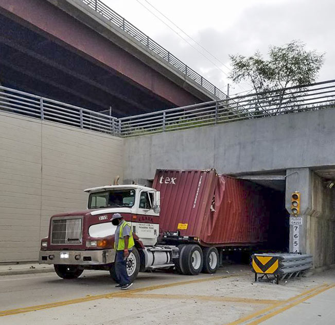
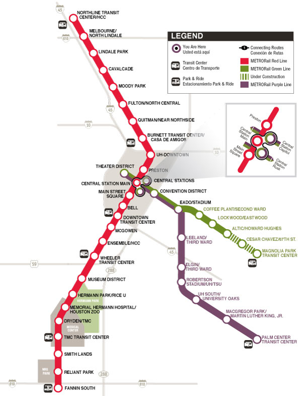
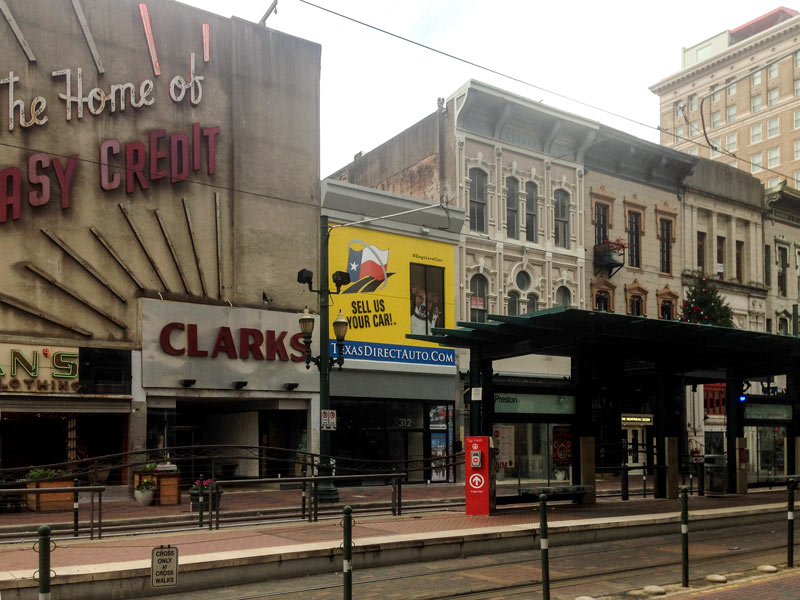
Following 2 deaths over the course of Super Bowl Week and Weekend resulting from cyclist-vs-light-rail collisions, the Chronicle‘s Dug Begley takes a look at how Houston stacks up nationally in terms of train-related accidents. The verdict, after a look through some National Transit Database data: Houston’s rail system has more walker and cyclist hits per mile “than any other major line in the country.” Houston breezes in at less that 100,000 train miles travelled per collision (compared to more than twice as many miles traveled per collision in Dallas, and more than 17 times as many in Boston). Metro CEO Tom Lambert tells Begley it may have to do with Houston’s high number of at-grade crossings and relative lack of barriers to keep people off the tracks. Begley says that the original decision to build the train at-grade isn’t itself unusual given the cost of elevated rail, but notes that “few places outside Houston have built their lines in some of the most congested and pedestrian-heavy areas of their respective urban regions.” [Houston Chronicle; previously on Swamplot] Photo of light-rail train dressed for Super Bowl Week: Christine Wilson

09/02/16 12:45pm

NRG stadium, NRG Park, Houston, 77054

METRO is currently seeking some public input on replacing the Reliant Park light-rail stop’s outdated moniker. The agency’s preface to the poll notes that the naming rights to the station itself were never a part of Reliant’s $300-million park-branding deal back in 2002, and  says any new name “needs to be reflective of the area, but should not include any reference to a corporate entity which might require another change in years to come.”

Setting aside any potential consideration of that plan from a reader to go ahead and get nearly 30 potential future name changes over with at once, the nominated names currently in the running are (drumroll):

CONTINUE READING THIS STORY

Saving NRG
07/25/16 4:00pm

1901 N. Main St., Near Northside, Houston, 77009

Chris Andrews has caught a few snapshots of what appears to be a soil sampling crew at work at 1901 N. Main St., formerly the site of Uncle Johnny’s Good Cars. Most of the 37,679-sq.-ft. property, occupying the block on the east side of N. Main between Hogan and Gargan streets (including the 1950s auto shop and the next door 1930s Beer’s Building), was transferred to a legal entity called Cerveza Four in May of 2015. Shortly thereafter, Keller Williams Realty posted the cheerily-soundtracked video listing below showing the ins and outs of the property, nestled between the Casa De Amigos city health clinic to the south and the former home of Alamo Thrifty Bail Bonds (now bike shop HAM Cycles 2) across Gargan:

CONTINUE READING THIS STORY

Movement on N. Main
07/22/16 4:30pm

METRORail Light-rail Map

In response to word from the Chronicle‘s Dug Begley this week that the Red Line’s Reliant Park light-rail stop might get its station name updated to an even older name, a Swamplot reader jumps on the case with a system-wide list of potential station name changes that might remain unaffected by the sale, rebranding, or demise of any nearby venues or landmarks. Begley notes it could cost Metro around $486,000 to change the Reliant Park stop’s signage. The agency says it would prefer to make the switch at the same time as 2 other station name changes currently under consideration (if they’re approved) — but not until after the Super Bowl, for which a set of cheaper temporary stickers will be deployed to help visitors find NRG Stadium.

The reader, in the spirit of Houston’s budding redesign-it-yourself urban planning scene, suggests that paying up now to swap out all the names that might become a problem later might actually be a long-term cost-saver. The proposed scheme makes sure every station name mentions a cross-street (or maybe a bayou), and keeps some references to existing transit centers, parks, or neighborhoods.

Here’s the full list of suggested switch-outs, separated by rail line, with the current names on the left:

CONTINUE READING THIS STORY

What’s In a Name
07/21/16 1:15pm

Palm Center Redevelopment Conceptual Plans

Like the looks of the conceptual drawing above, showing one of the possible ways to dress up HBDi’s Palm Center on Griggs Rd.? Or think you’ve got a better idea, and the real estate connections to pull it off? Adolfo Pesquera notes a current call for proposals from developers interested in redoing the site — you’ve got until early October to submit your own plan.

The changes wouldn’t happen all at once: HBDi’s documents show that it hopes to split up the work into a few different phases, dependent on how the economy looks. The first order of business would be to pretty up the old buildings on the site; the next phase would include adding a plaza and some office space, followed by the addition of whatever mix of office, retail, residential, and medical space is eventually selected.  Though most of the images included with the proposal guidelines are speculative, HBDi’s conceptual drawings do show some of the more concrete plans for the site, which is the last stop on Metro’s Purple Line:

CONTINUE READING THIS STORY

Rearranging The First Shopping Center
07/15/16 10:15am

METRO SUSPECTS YOU ARE ANNOYED BY TARDY TRAINS main-street-light-rail
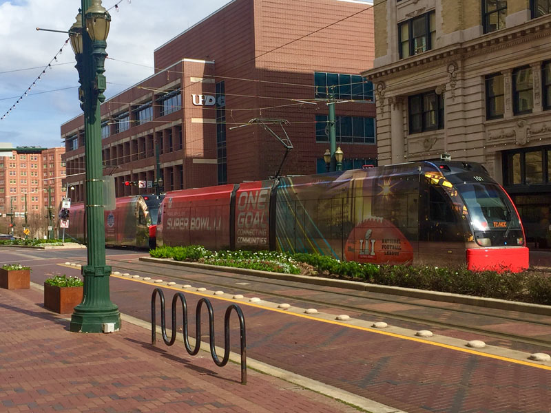
Though they don’t have the numbers to prove it, Metro officials are concerned that regularly late trains may be driving away riders, writes Dug Begley this week; even Metro board member Christof Spieler reportedly called the train’s recent timing stats “abysmal.” Begley writes that the timing problems in the last few years stem mainly from a set of sensors that count the axles of passing trains to help determine when they can be cleared to cross signaled intersections; problems with the devices (which are compounded by heat, humidity, and downtown traffic signal timing) can cause cascading delays through the rest of the train schedule. Siemens, which makes the devices, is still working on a fix at no cost to Metro. Begley notes that the trains haven’t been measured as meeting Metro’s monthly 95-percent on-time benchmark for acceptable performance since late 2013 (before the Red Line expansion opened); punctuality has dropped below 80 percent during at least 4 months in the last 2 years. [Houston Chronicle; previously on Swamplot] Photo of Main Street light rail: elnina via Swamplot Flickr Pool

05/23/16 2:30pm

COMMENT OF THE DAY: WHERE COULD TRAINS GO THAT BUSES COULDN’T? Trains to Office Buildings“Light-rail transit the way METRO has built it is slow, and actually adds somewhat to congestion by taking up a vehicular lane and messing up traffic flows (i.e. no left turns).  . . . Frankly, buses accomplish the job just about as well, even if they aren’t glamorous to some people. DART built grade-separated rail out to the [Dallas] suburbs and to the airport. It does go faster, since it doesn’t contend with stoplights and traffic. It also doesn’t clog up arterial roads. It was a different approach, but I think that it was the correct one.” [ShadyHeightster, commenting on Feds: Unused Richmond Light-Rail Funding Offer Now Expired, Getting Thrown Out]

05/20/16 1:30pm

Proposed University Light-Rail Line

A letter from the Federal Transit Authority released this morning by the office of long-time light-rail derailer US representative John Culberson announces that the comatose plans for rail construction along Richmond Ave. have now lost eligibility for federal funding due to the project’s lack of major progress, reports Dug Begley for the Houston Chronicle.

Previous plans for the University Line show it running from the Wheeler Red Line station along Richmond to Cummins St., where a turn south would take the line down to Westpark Dr. before continuing out to the Hillcroft Transit Center just past 59 — connecting along the way to the also-stalled Uptown rail-turned-bus-line). The Richmond part of the route includes a 1.7 mile stretch west of S. Shepherd Dr. that falls in Culberson’s district; the rest of the route to Hillcroft falls within 7th district territory as well.

CONTINUE READING THIS STORY

Use It Or Lose It
05/13/16 10:15am

This week’s video release from hometown country singer Robert Ellis takes viewers on a forlorn wandering tour of Houston’s downtown and surrounding thoroughfares, sans all of those pesky people and cars. Iconic cameos include the AIA’s future headquarters on the corner of Franklin and Commerce streets, the WALD warehouse sign at Live Oak and Rusk streets, and Bad News Bar on Main St.; the video also includes a hike down a dead-empty I-45 and associated entrance ramps, several frantic light-rail stops, and a dramatic reunion on the pedestrian bridge over Memorial Dr. at Sabine St. 

Video: Robert Ellis

Musical Background
04/04/16 10:00am

Hardy Yards sign, Burnett at Main St., Near Northside, Houston, 77026

The recent restoration of the Hardy Yards district sign’s upright stature and youthful good looks appears to have been short-lived — Christopher Andrews found the H sprawled flat on its back over the weekend, with a few of the other letters also looking less than fully vertical in the late-night shot above (peering east down Burnett St. from the corner with N. Main under the light-rail overpass). Metro says it’s on the case, again.

Photo of Hardy Yards signage: Christopher Andrews

N. Main at Burnett
01/12/16 1:15pm

AND NOW, WATCH THE RED LINE RUSH FROM BELL ST. TO BURNETT STATION AND BACK IN 49 SECONDS Take a break from the Downtown bustle, even if its just for a couple of seconds — frequent Swamplot photo contributor Jackson Myers captured this sped-up video of a light-rail ride from Bell St. up to Burnett Station, and even manages to hop in the conductor’s compartment for the return trip. Video: Jackson Myers via Swamplot inbox

12/03/15 2:15pm

Preston St. Station, Main St., Houston, 77002

Downtown light-rail riders: Your patronage of public transit isn’t enough. A giant billboard covering most of the facade of the 2-story building at 312 Main St. now urges passengers emerging from the northbound Preston stop to get rid of their vehicles altogether. The unassuming Houston Site Acquisitions storefront has scrapped its own above-door signage in favor of a story-high ad for Texas Direct Auto, complete with oversized doggie in the window.

Large-scale advertising for businesses not currently in the building is nothing new for this block of Main St.: Just next door, the sky-high neon above perpetually hungover neighbors Dean’s and Notsuoh still heralds the days of credit clothing retail. But the Texas Direct Auto ad incorporates the structure of the building itself, placing the large image of a small dog behind an actual window visible through a cutout in the wrap:

CONTINUE READING THIS STORY

Sell Your Car! No Money Down!
07/14/15 2:30pm

Burnett St., Near Northside, Houston

With a row of Downtown towers looking on from the south, 2 lanes are being added to Burnett St., along the northern boundary of the 50-acre site formerly known as the Hardy Rail Yards. The thickening runs between N. Main St. and Hardy St. At the western end of that stretch, next to the Burnett Transit Center stop on the Red Line’s northern extension, a new baby intersection has been born at Freeman St. just in front of the rail overpass, just up a ways from the N. Main tunnel:

CONTINUE READING THIS STORY

Grid Growth