02/26/19 12:00pm

Houston’s roadway overlords have begun eyeballing a proposal to swap out 11th St.’s current 4-lane setup between T.C. Jester and Pecore St. for a 3-lane configuration instead, consisting of one lane in each direction plus a center turning lane. The plan, says the city, would help to calm down residents who’ve been particularly frustrated trying to turn off 11th St. “at key intersections, such as Nicholson Street and Heights Boulevard.” It’d also give walkers and bikers less to look out for on their way across the street. And it paves the way for new landscaped barriers to run between the east and westbound sides of the road, offering pedestrians even more protection from oncoming automobiles.

Got an opinion about it? The city will be all ears at the Heights Fire Station at 12th St. and Yale next Tuesday from 6:30 to 8:30pm. There, officials plan to lay out their case for the changes and field some questions from the audience on the proposal.

The Straight and Narrow
10/31/18 1:00pm

Here’s another highlight from the city council’s meeting this morning: Plans to get rid of the cloverleaf interchange that moves traffic between Waugh Dr. and Memorial Dr. got the green-light and will be sent over to the Houston Galveston Area Council as part of an application for funding. The idea first emerged in the Buffalo Bayou Partnership’s 2002 Master Plan as a way to make room for more bayou-side park space at the crossroads. Right now, all the land adjacent to the ramps — shaded gray in the map above — is vacant, except for the portions lassoed by the circular roadways, where 4 isolated tree groves continue to undergo seasonal color changes. You can see they’re gone in the east-facing rendering at top included in the Partnership’s plan — replaced by inlets, islands, stormwater detention, and what looks to be a boathouse at the southeast corner of the 2 roads — all accessible from a network of new walkways that link up to existing bayou-adjacent trails.

In total, 16 new acres are expected to become part of the park — providing a continuous swath of green between Spotts Park and Cleveland Park, shown below on opposite sides of Waugh in a map from the 2002 plan:

CONTINUE READING THIS STORY

Traffic Lights Likely
10/29/18 12:45pm

CITY WISHLIST FOR DAIRY ASHFORD: WIDER ROADWAY, HIGHER BAYOU BRIDGE On city council’s agenda for tomorrow: a vote of support for widening Dairy Ashford Rd. from 2 to 3 lanes on each side between Westheimer and I-10. As part of the roadwork, the existing bridge across Buffalo Bayou would be rebuilt — potentially above 500-year floodplain level, though the city hasn’t decided yet. New, wider sidewalks are on the table, too. With the council’s blessing, Houston’s public works department would next submit an application for the project to the Houston Galveston Area Council, which could choose to help pay for it with state and federal money. [Houston City Council Agenda] Map: Houston City Council

04/17/18 4:30pm

AFTER HARVEY, WILL KINGWOOD PROPERTY TAXES BE ENOUGH TO FUND A NEW EVACUATION ROUTE? 
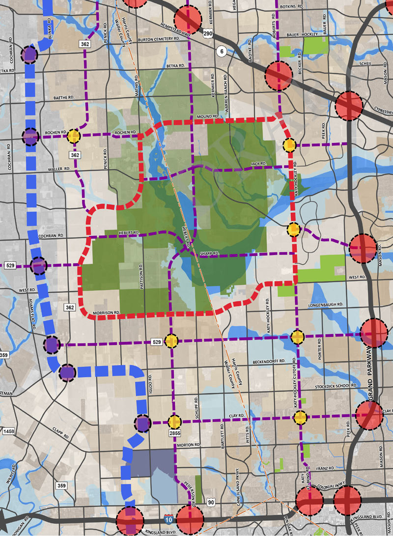
What would it take to turn Northpark Dr. into an all-weather evacuation route for Kingwood? “We’re going to have to bring it up out of that [floodplain],” TIRZ 10 consultant Ralph De Leon tells the Chronicle‘s Melainie Feuk, “which means the road’s going to have to come up.” The goal: “In a Harvey-like event, the road will still be passable and you can move people from the back of Kingwood to 69,” says city councilmember Dave Martin. TIRZ 10 had planned to issue bonds to fund a mile-and-a quarter segment of the project — between Russell Palmer Rd. and the Eastex Fwy. — but hit a snag. “Our big holdup,” TIRZ chairman Stan Sarman now says, “is waiting to see what’s going to happen to the appraised value.” Still in the works: the TIRZ’s funding application for the other portion of the road — east to Woodland Hills Dr. — which it plans to send in to the Houston Galveston Area Council sometime between June and July.  [Houston Chronicle] Map of Northpark Dr. between Eastex Fwy. and Woodland Hills Dr.: Houston City Council

05/19/17 11:45am

The light at the end of the N. Main St. tunnel beneath the Union Pacific Line was obscured for a bit this morning where the northbound side of the road re-emerges into tossed-coffee-cup range of the Burnett Transit Center light-rail stop (atop the topmost overpass in the shot above.) The semi that briefly plugged the hole looks to have scraped its way through the entire length of the tunnel before getting stuck at the northern exit. Transtar pinned the stopup to about 10:38 this morning; not much had changed as of 40 minutes ago (see below), but the road is now marked by professional traffic-watchers as cleared. 

CONTINUE READING THIS STORY

Yards from Hardy Yards
05/19/17 10:30am

ELYSIAN VIADUCT WORK UNEARTHS HISTORIC HOUSTON HERITAGE TRASH PILE The real value of the long-buried dump uncovered by the ongoing replacement of the Elysian St. bridge over I-10 and Buffalo Bayou, write Doug Boyd and Jason Barrett this week in the Chronicle, is in the opportunity it provides “to document the often-unwritten parts of our industrial heritage.” The dump, apparently built up over the early half of the 1900s in a former gully, serves as a springboard for the authors to talk trashHouston, they write, was one of the first cities to adopt widespread municipal garbage incineration, and lagged decades behind as most cities chose to stop doing it out of concern for public health. Spots like the one under Elysian St., they add, help fill in the gaps of knowledge of what happened to all the other trash that didn’t end up in a city incinerator or landfill — and who tended to live nearby. [Houston Chronicle; previously on Swamplot]  Photos: Adam J Williams

02/21/17 4:00pm

7200 Main St., TMC, Houston, 77030

The sign above announcing the proposed abandonment of the short dead-end stretch of N. Braeswood Blvd. running east of Main St. was captured in situ by a reader over the weekend. The roadway currently serves as the access road for the remaining Saint Nicholas School campus, though the school is planning to be all moved in at that new facility further south along Main St. in about a year and a half. That’ll free up the landf for whatever might be in the works by shell corporation 7200 Main St., which now owns both the school property and the 8-plus-acre tract north of the N. Braeswood segment, former site of barn-shaped restaurant The Stables.

To the east of the orange-roofed soon-to-be-former Saint Nicholas school, HCC’s  Coleman College for Health Sciences building looks to be just about wrapped up, at least in terms of exterior finishes:

CONTINUE READING THIS STORY

Medical Center Excision
02/03/17 9:30am

Super Bowl LI Road Closures, Downtown

An essential addition to the growing list of guides for Houstonians on where not to go this weekend: the above map of road closures around the George R. Brown Convention Center district. Both red shading and cross-hatching mark the temporary carless zones, while a dashed black line shows the location of the perimeter fence for area events. Meanwhile, miles away at actual Super Bowl location NRG Stadium, other street closures were planned to go into effect yesterday evening (and are scheduled to last through Monday morning):

CONTINUE READING THIS STORY

Lines of Scrimmage
05/27/16 10:30am

BRYAN POLICE: PLEASE STOP DRIVING INTO FLOODWATER SO WE CAN WORK ON TORNADO PROBLEMS Flood-related Road Closures, 5/27
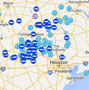
Dozens of roads are still closed this morning following yesterday’s heavy storms to the north and west. The National Weather Service reports that the nearly 17 inches of rain measured over 24 hours at its Brenham station would by itself beat the total for the 3rd-wettest month on station record (and fall less than an inch short of second place). Bryan-College Station’s The Eagle reported yesterday that the Bryan Police Department was urging drivers to stay off the roads, as first responders were getting tied up with sinking vehicle calls while also trying to respond to calls related to the tornado that touched down near Highway 6 and Briarcrest Dr. At least 50 houses were reported damaged and 3 destroyed; other possible tornado-related incidents reported in the area include damage to the Miramont Country Club and to the Wallace Pack Unit prison in Navasota. [National Weather Service, The Eagle] Map of road closures: TxDOT

05/03/16 1:00pm

Proposed Changes to Major Thoroughfare Plan near 290 beyond Grand Pkwy.

If you missed yesterday’s meeting in Hockley, you have until Wednesday to send Harris County your thoughts on the map above, from the official county study of road network expansion proposed between I-10 and 290 west of the Grand Pkwy. The thick red dashes mark a proposed loop road circling around almost the entirety of the Katy Prairie Conservancy‘s land preserve (shown as the darkest green blocks, amid slightly-grayer-green agricultural/undeveloped land and a few kelly-green public parks). Purple dashes show the proposed routes of new or expanded thoroughfares, some of which cut through the preserve and cross through the Cypress Creek floodway (shown as a blue underlay making a rough U through the conservancy’s land).

Further west (marked in blue dashes) is the not-yet-planned-but-still-showing-up-in-planning-maps route of Houston’s proposed outer-outer-outer loop, SH 36A (formerly nicknamed the Prairie Parkway). The map above also includes overlays of Harris County’s future development predictions, with dark taupe showing existing development and slightly lighter taupe showing expected expansion.

For comparison, here’s the Katy Prairie Conservancy’s map of west Houston; currently developed areas are marked in gray, the organization’s protected areas are marked in green, and the dashed green band shows how far the prairie ecosystem used to extend:

CONTINUE READING THIS STORY

Up the Watershed
12/21/15 1:30pm

Solstice Alignment in Montrose

Still hunting for that perfect spot to boil up some fresh eye of newt during tonight’s winter solstice sunset? Github user and mapping fanatic Demeter Sztanko has you covered, a reader tells Swamplot just in time. Sztanko has programmed an interactive map highlighting all the streets aligned with the summer and winter solstices — so you too can get in on the mystical fun from a bit closer to home than Wilshire. Choice picks for an in-line solstice vantage include that entire off-kilter neighborhood north of Westheimer between Waugh and Mandell (pictured above) and certain segments of the South Loop.

CONTINUE READING THIS STORY

G.I.S. for Druids