
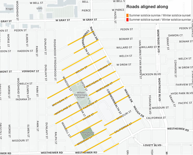
Still hunting for that perfect spot to boil up some fresh eye of newt during tonight’s winter solstice sunset? Github user and mapping fanatic Demeter Sztanko has you covered, a reader tells Swamplot just in time. Sztanko has programmed an interactive map highlighting all the streets aligned with the summer and winter solstices — so you too can get in on the mystical fun from a bit closer to home than Wilshire. Choice picks for an in-line solstice vantage include that entire off-kilter neighborhood north of Westheimer between Waugh and Mandell (pictured above) and certain segments of the South Loop.
***
Other options include a number of streets just west of Hobby Airport, much of Liberty Rd. on its way east to rejoin 90 East, and sporadic stretches of neighborhood roads along the meandering path of Brays Bayou — though the Montrose locale may offer your best chance of finding a wizard hanging around. Sztanko’s map set is adjusted to reflect solar angles in major cities across the globe; check out the lay of the land elsewhere right here.
Third link in this post needs target URL to be fixed — it returns a 404 error as-is.
But once I made it to the webpage, it confirmed that I live in a “solstice neighborhood” too. Yay — I’ll try to catch that sunset tonight!
Thanks, slugline! It’s fixed now.
That’s actually Hyde Park, the former rice farm of one Mirabeau B. Lamar.
I think you misspelled Cherryhurst.