
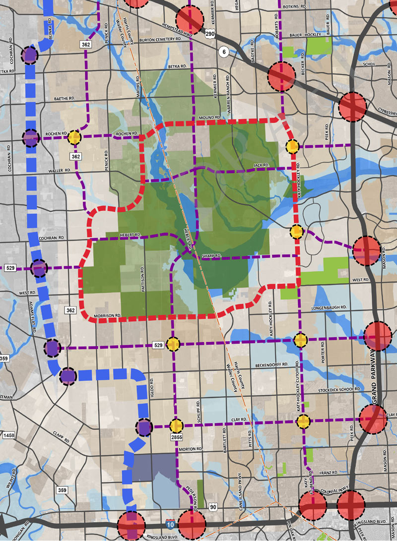
If you missed yesterday’s meeting in Hockley, you have until Wednesday to send Harris County your thoughts on the map above, from the official county study of road network expansion proposed between I-10 and 290 west of the Grand Pkwy. The thick red dashes mark a proposed loop road circling around almost the entirety of the Katy Prairie Conservancy‘s land preserve (shown as the darkest green blocks, amid slightly-grayer-green agricultural/undeveloped land and a few kelly-green public parks). Purple dashes show the proposed routes of new or expanded thoroughfares, some of which cut through the preserve and cross through the Cypress Creek floodway (shown as a blue underlay making a rough U through the conservancy’s land).
Further west (marked in blue dashes) is the not-yet-planned-but-still-showing-up-in-planning-maps route of Houston’s proposed outer-outer-outer loop, SH 36A (formerly nicknamed the Prairie Parkway). The map above also includes overlays of Harris County’s future development predictions, with dark taupe showing existing development and slightly lighter taupe showing expected expansion.
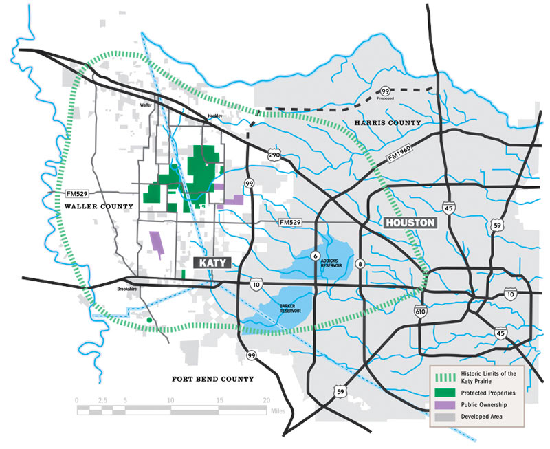
For comparison, here’s the Katy Prairie Conservancy’s map of west Houston; currently developed areas are marked in gray, the organization’s protected areas are marked in green, and the dashed green band shows how far the prairie ecosystem used to extend:
***
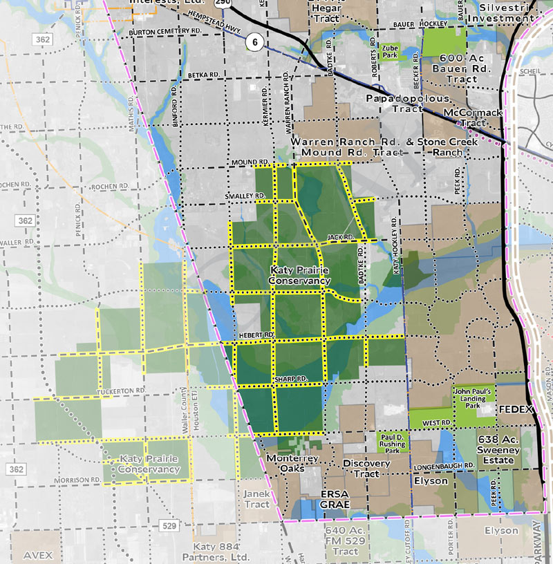
County engineer John Blount tells David Fehling of Houston Public Media that the Katy Prairie Conservancy should be happy with changes already made to the plan, which breaks with Houston’s since-1942-traditional 1-mile-by-1-mile thoroughfare grid pattern. Here’s what that plan originally looked like:
The conservation group says that while some planned roads have been eliminated, others have been added, and that flooding and habitat issues raised at the 1 meeting it was invited to attend back in September are not actually addressed by the current version of the plan (which was released in March).
Meanwhile, the Houston Galveston Area Council’s technical advisory committee heard a presentation last month proposing a feasibility study for the SH36 segment shown on the top map; Jay Crossley of think tank Houston Tomorrow wrote in the Houston Chronicle last week that the committee will vote on funding that study at May’s monthly meeting.
- As Houston Sprawls, New Roads Proposed For Katy Prairie [Houston Public Media]
- US 290 Area Major Thoroughfare Study, March 2016 [HCPID]
- Previously on Swamplot: This Week, Houston Begins Slicing What’s Left of the Katy Prairie in Two
Maps: Harris County Planning and Infrastructure Department (top and bottom), Katy Prairie Conservancy (middle)


You can’t get more Houston than planning the next exurban loop road before the concrete’s even set on the latest exurban loop road.
KPC is a legit org with no anti-development agenda. I know each employee personally and can attest that they are not anti anything. Rather they are trying to preserve a fraction of what once existed out there. In this case, the road can easily be moved around their preserve. Growth can continue and they can keep the preserve intact.
I don’t get it. Why put roads through there anyway? Can’t we just leave this tiny part of the Earth alone. The Katy Prairie represents one of the most endangered ecosystems on Earth. There is so little of the natural beauty of Houston left. Why do people feel like they deserve to have roads to drive on everywhere and the inconvenience of a detour is more important than the plants and animals that live here? The county engineer is basically saying, ‘hey you should be happy that we aren’t going to ruin the area as much as we originally planned.’
Houston makes me sad sometimes… :(
I say we just pave the whole thing and then build whatever grasslands / parks we want on top of it.
That would be a great place for a new Corps of Engineers reservoir. /trolling Its true though.
.
The entire concept itself notwithstanding, that hook in the Prairie Parkway (SH 36A) seems awfully inefficient. I want to know the story behind it being there.
Why in gods name is the government subsidizing all this westward expansion? I guess if the goal is to let the city of Houston fail and create a new conservative city to replace it, then kudos. Job well done. But they need to start building skyscrapers over there or else I-10 and 290 will collapse under the strain of all those commuters going into town.
I can see Harris County leadership and HGAC have made an incredible leap in understanding the need to preserve some open areas to prevent further flooding. “Those who fail to learn from the past are doomed to repeat it” should be our new city/county motto. Since Houston has been successful with the current and past development models, it makes sense, of course, that no change is needed. Never mind we already have proof that we have a problem. Denial ain’t just a river in Egypt.
Speculations on development in that area have to confront the market demand realities of trying to sell single family homes in Waller and Royal ISDs. Not an easy hurdle, since schools are the most important reason folks would choose to live in a subdivision on the urban periphery like that. I have to wonder if Sealy and Bellville might be more the focus of residential development for that reason, no matter the longer commute. In other words, skip out to where the schools are better perceived by educated suburbanites. Of course maybe that just means the western Katy Prairie will become another version of North Katy / South Cy-Fair ISDs, single family havens for the working classes that are avoided like the plague by more discerning suburbanites.
.
Regarding the road pattern, when through roads get restricted so that the grid becomes sparse, like in this plan, the commute traffic brought by whatever development does occur gets congested even quicker. Look at the nightmares created by the Addicks and Barker Reservoirs in this manner – a huge area of traffic is funneled to SH 6 / Clay / Eldridge etc. with predictably nasty results. Urban development needs a pretty granular grid / network (for all travel modes), and more granular than every 1 mile, which as noted is the current standard. I would propose a 1/2 mile grid of thoroughfares and connectors.
.
Niche, the bend in 36A reminds me of a more exaggerated version of the one on the Sam Houston Tollway near US 290.
@Commenter7 – Why is the government subsidizing all this westward expansion? Go look at who many of the major political donors from this region are, and you’ll understand why. All the big developers. They buy cheap land in the middle of nowhere, then pay off the legislators to build major roads to it so they can develop.
If Harris County was anything other than a government arm of Houston’s suburban real estate developers, they would be taking every dollar proposed for building roads out in the Katy Prairie and put it into buying up every piece of farm land they can get their hands on around the preserve and restore it to its original prairie habitat complete with prairie pot holes, wetlands and prairie grasses and create a permanent Harris County flood control preserve to keep the City’s flooding problems from getting any worse before the sprawl builders get their hands on that land.
And yes. That was a spectacular run-on sentence. Thank you for noticing.
I’m flummoxed by that North/South route through the Prairie land.
Pave the prairie? What prairie?
Stories like these are baffling to me. Too much is not enough in Texas. Build more and more, farther and farther away. Enable more sprawl, and more generic commercial development – Chili’s, Whataburger, Subway, Pizza Hut, Applebee’s, Sonic, Mattress Firm, repeat, repeat.
Sure, Local Planner,
A 1/2-mile grid would be better for auto traffic than the existing-ish 1-mile-square plan.
But an 88-yard grid would be more efficient still! (Because we need to assume future development will have Waller looking like Manhattan one day.)
Funny how much forethought is in the expansion of roads but not so much in the provision of services, schools.
This article is everything that’s so, so wrong with the mentality of Houston development. Smh.
On a more serious note than my last comment, the formula to calculate the area of a circle is A=Ï€*r^2. The significance of that in Houston is that if you are aggressive and hold the average density of urbanized area as a constant and push outward from the middle at a constant rate of acreage demand per year, then as the radius of your circle of development expands, that amount of land available to development increases exponentially. Every additional mile outward takes longer to fill up with development. (This is aggressive because we should reasonably expect that the share of infill construction will likely increase over time.)
.
For example, going from a 20-mile circle to a 30-mile circle takes land area from 1,256 sq. mi. to 2,826 sq. mi., a 50% increase in radius but a 125% increase in land area. At 20 miles from the CBD is Spring, the near edge of Cinco Ranch, Manvel, and Baytown. There’s development beyond that in places, yes, but there also are huge swaths to the south and northeast that lack much development. We don’t even have to use the CBD as a centroid, but all the same let’s just go on that model to demonstrate the point. At 30 miles is just beyond the other side of Cinco Ranch, just past Rosenberg, Liverpool, La Marque, Cove, beyond-Eastgate, Patton Village, College Park, and not-quite-Hockley. To get to FM 529 & FM 362 is at about the 36-mile mark (224% more land than 20mi.), and you’re still not outside the “Prairie Parkway”. Praire View is at about 42 miles away (341% more land than 20mi.)
.
Houston’s suburbs won’t get that far, at least not generally, not except for the acreage subdivisions and ranchettes. Maybe south of I-10 and out to the Brazos River (a physical barrier to growth) over the course of 20 or 30 years. Okay I’d maybe buy that one, and also right up along the spoke freeways — but developed land area between the spokes won’t fill out so quickly. Monaville is staying Monaville for a good 40 to 60 years under very aggressive assumptions, but personally I think probably forever. And there’s not going to be a lot of traffic, not for a freeway, certainly for a toll road.
.
All the same, its good to have a plan. That is the point of this. Its good to have contingency strategies in place. Its good to have rules in place that preserve ROWs. That hasn’t been explained adequately to the public, but that’s what this is. Its a long-term non-binding plan, not a groundbreaking ceremony. Take it easy out there.
@ TheNiche… I get what you are saying…but don’t you think our ‘long term’ plan should include preserving the natural heritage of the state? Sure, we could use the line of reasoning that the preservation of this land is for flood control but what about preserving the land for the sake of it being a unique feature of Texas and of the US and Earth in general?
I’m not sure how paving over and ‘developing’ the entire state of Texas should be in anyone’s ‘long term’ plan. The trouble here is that people aren’t thinking ‘long term’, that is; the next 100 plus years. People are thinking ‘long term’ as in the next 30 years. They, and we all (to a certain extent), are trying to attain short term profits at the expense of our long term sustainability (as Houstonians, Texans, Americans, and citizens of Earth).
@ movocelot: The Republic of Texas in 1837 created various categories of immigrants in order to assign land grants. The coastal regions and plots fronting major rivers were for the most part already claimed by settlers that had arrived under Mexican governance, so what was allocated for new settlers was primarily west and north of the coast and between rivers. Most of these grants were made in 640-acre (1-square-mile) increments or double or half that. These were made as geometrically regular as possible given natural features. In the nearly-featureless prairies west of Houston and notably in the Katy Prairie, you had these perfect grids domination much of the plat maps. Roads and fences were built to follow that pattern for obvious reasons. The legacy of this system has shaped policy ever since.
.
When the MFTP was created in the 1940s, proposing 1-mile grids was a de facto strategy. You can hardly blame them. The tightest grid that would’ve been feasible would have been based on 1/2-mile increments. I tend to concur with Planner that 1/2-mile grids would’ve been closer to a spacing that is suggested by a traffic optimization function that utilizes any reasonable calculus, and I also think that doing so would make many subdivisions easier to walk out of (which becomes important after they’re 30 years old, depreciated, full of poor people, and those people can’t walk out to stores, employment, government services, or transit). However, anything tighter than 1/2-mile or between 1- & 1/2-mile grids just isn’t feasible in the Katy Prairie area due to the legacy of land grants.
I heard a representative of the Katy Prairie Conservancy on the radio yesterday saying they opposed the ring road because it would prevent future growth of the prairie. Imagine that. Someone is plotting the future growth of uninhabited space. I mean, we all know that human civilization will fail, and humans may become extinct one day, but to worry about the effect of a road on that post-apocalyptic future seems particularly misanthropic.
.
This will all be prairie again soon enough.
@ Duston: That comment about using the Katy Prairie Conservancy land for flood control was just trolling. I even ended the comment with “/trolling”. Anything like that should be (or have been) a bit further downstream.
Niche, while the math you highlight is obviously true, the complicating factors are: (1) where dense employment has chosen to occur and (2) where the “good schools” are perceived to be. Years of observing Houston suburban development have led me to realize that any area within a 45-minute drive of a significant employment center – such as the Energy Corridor – is market-eligible for conventional suburbanization (as opposed to large-lot exurban/rural subdivisions), especially if it is perceived to offer superior schools than closer-in locations. It’s astonishing the lengths college-educated or otherwise middle class and affluent parents are willing to go to – and the otherwise acceptable housing (in terms of size and yard expectations and distance to employment) they are willing to pass over just so their children can attend school with a preferred demographic profile. In this context, jumping the Brazos to tap into the Energy Corridor / Katy employment market (when it eventually re-energizes) would be newsworthy, and a little bit of a mental leap, but ultimately not a big deal. Just look at the significant growth that’s already planned for Magnolia and Montgomery – Montgomery! – primarily driven by paranoid parents who want to “do it for the kids.”
@Local Planner, you make very valid points. I’d also add that some of that type of migration to ex-urbs is not only school based, but driven by a desire by some folks to “want to live in the country” I’ve seen co-workers move to Magnolia and Fulshear 15 years ago for the “country lifestyle” only to be now surrounded by development and planning their next move even further out.
@ Planner: You’re absolutely right. Houston doesn’t just build out in concentric circles radially from the CBD (although the predictive modeling from H-GAC works from that bizarre assumption). For the purposes of the math here, I wanted to keep it really simple and digestible and the radius math fits the bill to illustrate a general concept. My posts are waaaay the hell too long as it is.
.
But I still say that Monaville will always be Monaville. Maybe Monaville-plus-ranchettes.
Our tax dollars would be better spent subsidizing contraceptives.
Nim takes nimby to a new level.
Nim, That is a wonderful idea.